Tidore
| Tidore | ||
|---|---|---|
| Island and City | ||
|
Tidore Island, as seen from Ternate Island. | ||
| ||
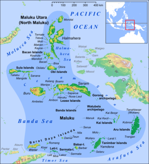 Tidore island in the north of Maluku Islands | ||
 Tidore Location off Halmahera | ||
| Coordinates: 0°41′N 127°24′E / 0.683°N 127.400°E | ||
| Country | Indonesia | |
| Province | North Maluku | |
| Area | ||
| • Total | 9,564.7 km2 (3,693.0 sq mi) | |
| Population (2010) | ||
| • Total | 98,025 | |
| • Density | 10/km2 (27/sq mi) | |
| Time zone | WIT (UTC+9) | |
| Area code(s) | +62 921 | |


Tidore is a city, island, and archipelago in the Maluku Islands of eastern Indonesia, west of the larger island of Halmahera. In the pre-colonial era, the kingdom of Tidore was a major regional political and economic power, and a fierce rival of nearby Ternate, just to the north.
Geography
Tidore Island consists of a large stratovolcano which rises from the seafloor to an elevation of 1,730 m (5,676 ft) above sea level at the conical Kiematabu Peak on the south end of the island. The northern side of the island contains a caldera, Sabale, with two smaller volcanic cones within it.
Soasio is Tidore's capital. It has its own port, Goto, and it lies on the eastern edge of the island. It has a mini bus terminal and a market. The sultan's palace was rebuilt with completion in 2010.[1]
History
Tidore was a spice-funded sultanate that was founded in 1109, and spent much of its history in the shadow of Ternate, another sultanate.[2]
The sultans of Tidore ruled most of southern Halmahera, and, at times, controlled Buru, Ambon and many of the islands off the coast of New Guinea. Tidore established an alliance with the Spanish in the sixteenth century, and Spain had several forts on the island. There was mutual distrust between the Tidorese and the Spaniards but for the Tidorese the Spanish presence was helpful in resisting the incursions of the Ternateans and their ally, the Dutch, who had a fort on Ternate. For the Spanish, backing the Tidore state helped check the expansion of Dutch power that threatened their nearby Asia-Pacific interests, provided a useful base right next to the centre of Dutch power in the region and was a source of spices for trade.
Before the Spanish withdrawal from Tidore and Ternate in 1663, the Tidore sultanate, although nominally part of the Spanish East Indies, established itself as one of the strongest and most independent states in the region. After the Spanish withdrawal it continued to resist direct control by the Dutch East India Company (the VOC). Particularly under Sultan Saifuddin (r. 1657–1689), the Tidore court was skilled at using Dutch payment for spices for gifts to strengthen traditional ties with Tidore's traditional peripheral territories. As a result, he was widely respected by many local populations, and had little need to call on foreign military help for governing the kingdom, unlike Ternate which frequently relied upon Dutch military assistance.
Tidore long remained an independent state, albeit with growing Dutch interference, until the late eighteenth century. Like Ternate, Tidore allowed the Dutch spice eradication program (extirpatie) to proceed in its territories. This program, intended to strengthen the Dutch spice monopoly by limiting production to a few places, impoverished Tidore and weakened its control over its periphery.
In 1781 Prince Nuku left Tidore and declared himself Sultan of the Papuan Islands. This was the beginning of a guerilla war which lasted for many years. The Papuans sided with the rebellious Prince Nuku. The British had sponsored Nuku as part of their campaign against the Dutch in the Moluccas. Captain Thomas Forrest was intimately connected with Nuku and represented the British as ambassador.
The sultanate was abolished in the Sukarno era and re-established in 1999 with the 36th sultan.[2] Tidore was largely spared from the sectarian conflict of 1999 across the Maluku Islands.[2]
Administration

The island constitutes a municipality (kotamadya) within the province of North Maluku. The municipality covered an area of 1,643.5 square kilometres (634.6 sq mi) and had an Census population of 89,506 in 2010, the mainland part (Oba) became the city of Sofifi, the new provincial capital. This leaves 53,309 as the population covering 129 km2 of land.[3]
The municipality includes the island of Tidore, together with two small islands (Maitara and Mare), and the Oba section of Halmahera Island. It is divided into eight districts (kecamatan), namely Oba, Oba Selatan (South Oba), Oba Tengah (Oba Central), Oba Utara (North Oba), Tidore, Tidore Timur (Tidore East), Tidore Selatan (South Tidore), and Tidore Utara (North Tidore). The four Obas cover the parts of the municipality on Halmahera, while the four Tidores cover Tidore Island and the two small islands.
Notes
References
- Andaya, Leonard Y. 1993. The world of Maluku: eastern Indonesia in the early modern period. Honolulu: University of Hawaii Press. ISBN 0-8248-1490-8.
External links
| Wikisource has the text of the 1911 Encyclopædia Britannica article Tidore. |
- The History of the Spanish Presence in the Moluccas (Indonesia): the Spanish Forts in Tidore Island, Maluku, Indonesia by Marco Ramerini
- "Tidore". Global Volcanism Program. Smithsonian Institution.
Coordinates: 0°41′N 127°24′E / 0.683°N 127.400°E
Regencies and cities of North Maluku | ||
|---|---|---|
Capital: Sofifi | ||
| Regencies | ||
| Cities | ||
|  | |||||||||||||||||||||||||||||||||||||||||||||||||||||||||||||||||||||||||
|
| ||||||||||||||||||||||||||||||||||||||||||||||||||||||||||||||||||||||||||
| ||||||||||||||||||||||||||||||||||||||||||||||||||||||||||||||||||||||||||
| ||||||||||||||||||||||||||||||||||||||||||||||||||||||||||||||||||||||||||
| ||||||||||||||||||||||||||||||||||||||||||||||||||||||||||||||||||||||||||
| ||||||||||||||||||||||||||||||||||||||||||||||||||||||||||||||||||||||||||