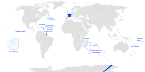
Mascarene Islands
| Native name: <span class="nickname" ">Mascareignes | |
|---|---|
 Topographic map of Mascarene Islands | |
 | |
| Geography | |
| Major islands | Mauritius, Réunion, Rodrigues |
| Administration | |
The Mascarene Islands (or Mascarenhas Archipelago) is a group of islands in the Indian Ocean east of Madagascar consisting of Mauritius, Réunion and Rodrigues. The collective title is derived from the Portuguese navigator Pedro Mascarenhas, who first visited them in the early sixteenth century. The islands share a common geologic origin in the volcanism of the Réunion hotspot beneath the Mascarene Plateau and form a distinct ecoregion with a unique flora and fauna.
Location and description
The archipelago comprises three large islands, Mauritius, Réunion, and Rodrigues, plus a number of volcanic remnants in the tropics of the southwestern Indian Ocean, generally between 700 and 1500 kilometres east of Madagascar. The terrain includes a variety of reefs, atolls, and small islands. They present various topographical and edaphic regions. On the largest islands these gave rise to unusual biodiversity. The climate is oceanic and tropical.
Geology

The islands are volcanic in origin; Saya de Malha (35 mya) was the first of the Mascarene islands to rise out of the Indian Ocean due to the Réunion hotspot, followed by Nazareth Bank (some 2,000 years later), Soudan Bank and Cargados Carajos. The youngest islands to form were Mauritius (7–10 mya), the oldest of the existing islands, created along with the undersea Rodrigues ridge. The islands of Rodrigues and Réunion were created in the last two million years. Réunion is the largest of the islands (2,500 km2), followed by Mauritius (1,900 km2) and Rodrigues (110 km2). Eventually Saya de Malha, Nazareth and Soudan were completely submerged, Cargados Carajos remaining as a coral atoll.[1] The Réunion hotspot was beginning to cool and Rodrigues came out as a tiny island. Had erosion not taken place, Cargados Carajos would have been a large volcanic island, and the Mascarenes would have been an archipelago of seven or more (counting Saya De Malha, Nazareth and Soudan) large, populated islands, rather than the three (Mauritius, Reunion, Rodrigues) that remain today.
Réunion is home to the highest peaks in the Mascarenes, the shield volcanoes Piton des Neiges (3,069 m) and Piton de la Fournaise (2,525 m). Piton de la Fournaise, on the southeastern corner of Réunion, is one of the most active volcanoes in the world, erupting last on 2 January 2010. Piton de la Petite Rivière Noire (828 m) is the highest peak on Mauritius, and the gentle hills of Rodrigues rise to only 390 m.
The Mascarene Plateau is an undersea plateau that extends approximately 2000 km, from the Seychelles to Réunion. The plateau covers an area of over 115,000 km2 of shallow water, with depths ranging from 8 to 150 meters, plunging to 4000 m to the abyssal plain at its edges. The southern part of the plateau, including the Saya de Malha Bank, Nazareth Bank, Soudan Banks and Cargados Carajos Shoals (Saint Brandon) (then one large island), was formed by the Réunion hotspot. These were once volcanic islands, much like Mauritius and Réunion, which have now sunk or eroded to below sea level or, in the case of the Cargados Carajos, to low coral islands. The Saya de Malha Bank formed 35 million years ago, and the Nazareth Bank and the Cargados Carajos shoals after that. Limestone banks found on the plateau are the remnants of coral reefs, indicating that the plateau was a succession of islands. Some of the banks may have been islands as recently as 18,000–6,000 years ago, when sea levels were as much as 130 meters lower during the most recent ice age.
Flora


The habitats of the islands differ in size, topography, age, and in proximity to the nearest major land mass, namely (Madagascar). As is common among remote islands, the Mascarene fauna and flora display a high degree of endemism; they include over a thousand species of which several hundred are endemic. There also are many introduced species but until Europeans first settled the islands in the sixteenth century the Mascarenes are not known to have harboured any human populations, so much of the island's wildlife, which would have gone extinct much earlier had any native people lived there, was still flourishing during the early days of settlement.
In prehistoric times the islands were covered in a diverse range of tropical moist broadleaf forest. At present however, though the Mascarene islands form a distinct ecoregion, known as the Mascarene forests, the ecoregion is not homogeneous, and comprises at least five fairly distinct vegetation zones that reflect variations in altitude and in moisture regime.
The freshwater biota includes coastal wetlands and swamp forests, grading into rainforest to windward and to lowland dry forest to leeward. Dryland areas include palm savannas, montane deciduous forests and heathlands on the highest peaks of Réunion.[2] The dry lowland forests range from sea level to elevations of some 200 metres. They occur in regions with less than 1000 mm average annual rainfall. These dry lowland forests are dominated by palms such as Latania species and Dictyosperma album, and by the palm-like screw-pines (Pandanus species). There also are sclerophyllous trees such as species in the family Combretaceae, for example Terminalia bentzoe [2]
Semi-dry sclerophyllous forests occur between the coastal areas and an altitude of 360 metres on Mauritius and Rodrigues. On Réunion only small relict patches remain at altitudes up to 750 metres on the western slopes. This semi-dry ecosystem occurs where the average annual rainfall is about 1000–1500 mm. Characteristic families of the flora in the include Ebenaceae, with ebony species in the genus Diospyros. Other tree families are occurring such as Pleurostylia spp. (Celastraceae), Foetidia spp. (Lecythidaceae), Olea europea subsp. africana (Oleaceae), Cossinia pinnata (Sapindaceae), Dombeya spp. (Sterculiaceae), and a variety of Sapotaceae species Sideroxylon boutonianum, Sideroxylon borbonicum spp. and Mimusops. The ecosystem is also home to several spectacular endemic species of Hibiscus (Malvaceae) Zanthoxylum spp. (Rutaceae), Obetia ficifolia (Urticaceae), and Scolopia heterophylla (Flacourtiaceae).[2]
The lowland rainforests are characterized by dense evergreen forests, with a canopy exceeding 30 meters. With an average annual rainfall of 1500–6000 mm, occur on Mauritius island above 360 m and all over the eastern lowlands from the coast to 800–900 m and, on the western side. On Réunion island the Lowland rainforests is present from 750 to 1100 m. These forests have a canopy of tall trees up to 30 m high and represent the more diversified plant communities of the Mascarene Islands. Characteristic plants include trees in the plant family Sapotaceae e.g. Mimusops spp. Labourdonnaisia spp., Hernandiaceae Hernandia mascarenensis, Clusiaceae Calophyllum spp., and Myrtaceae Syzygium spp., Eugenia spp., Sideroxylon spp., Monimiastrum spp.; shrubs in the plant family Rubiaceae (Gaertnera spp., Chassalia spp., Bertiera spp., Coffea spp.); bamboos as Nastus borbonicus, numerous species of orchids (e.g., Angraecum spp., Bulbophyllum spp.) and ferns e.g., Asplenium spp., Hymenophyllum spp., Trichomanes spp., Elaphoglossum spp., Marattia fraxinea.[2]
The cloud forests, a dense type of hygrophilous rainforest, occur on Réunion between 800 and 1900 m on eastern slopes with an average annual rainfall 2000–10,000 mm, and between 1100 and 2000 m on western slopes with an average annual rainfall 2000–3000 mm and are also restricted to a small area of Mauritius around the montane area "Montagne Cocotte" above 750 m on Mauritius with an average annual rainfall 4500–5500 mm. These type of forests is present on both islands with a canopy of 6 to 10 m high. They are rich in epiphytes (orchids, ferns, mosses, lichens), emergent tree ferns (Cyathea spp.), and, originally, palms (Acanthophoenix rubra), but these now survive only in areas of Réunion where poaching has not wiped them out. Untransformed cloud forests still cover large areas on Réunion with 44,000 ha in 2005. These forests are characterized by trees such as Dombeya spp., on the Réunion island only, and species in the plant family Monimiaceae (Monimia spp., Tambourissa spp.) as canopy species, with small trees and shrubs sucth as Psiadia spp. (Asteraceae) and Melicope spp. (Rutaceae) in the understory. They also include large areas of three monodominant plant communities, forests with Acacia heterophylla (Fabaceae) as canopy species that are very similar to Acacia koa forests in Hawaii, thickets dominated by Erica reunionensis (Ericaceae), or hyperhumid screw-pine forest (Pandanus montanus).[2]
The subalpine scrub with an average annual rainfall 2000–6000 mm is above the tree line to 1800–2000 m, at elevations where frosts occur regularly in winter, dominated by shrubs in the plant families of Ericaceae (Erica spp.), Asteraceae (Hubertia spp., Psiadia spp., Stoebe passerinoides), and Rhamnaceae (Phylica nitida), with some notable endemic species suchs Heterochaenia rivalsii (Campanulaceae), Eriotrix commersonii (Asteraceae), and Cynoglossum borbonicum (Boraginaceae).[2]
The summits of the volcanoes are covered by large mineral areas with sparse grasslands rich in endemic grasses (Poaceae, e.g., Festuca borbonica, Agrostis salaziensis, Pennisetum caffrum) and orchids (Orchidaceae, e.g., Disa borbonica), ericoid thickets, or thickets of the small tree Sophora denudata (Fabaceae), depending on substrate texture and age.[2]
Finally the Mascarene Islands are surrounded by approximately 750 square km of coral reef. Rodrigues has nearly continuous fringing reefs bounding an extensive lagoon with deep channels, whereas Mauritius is surrounded by a discontinuous fringing reef and a small barrier reef. In contrast, Réunion has very short stretches of narrow fringing reefs along the western and southwestern coasts only. The islets of the Cargados Carajos Shoals, which have a very depauperate terrestrial biota owing to being so low-lying and swamped during cyclones, are bound to the east by an extensive arc of fringing reef, which accounts for ∼30% of the reefs of the Mascarene Islands. Lagoon reefs and reef flats are dominated by scleractinian corals such as branching and tabular Acropora, Porites massives, foliaceous Montipora and Pavona, and sand consolidated with beds of seagrass such Halophila spp. (Hydrocharitaceae). Among coral reef fi shes, wrasses (Labridae), damselfish (Pomacentridae), carnivorous groupers (Serranidae), and surgeonfishes (Acanthuridae) have many species.[2]
Most of the indigenous Mascarene flora and fauna are thought to have descended originally from Madagascan and African ancestors. The Mascarenes are home to many endemic species of Dombeyoideae, the monotypic genus Psiloxylon (Psiloxylon mauritianum), and members of the family Monimiaceae, Escalloniaceae and Foetidia. Indigenous trees for example include species in the genera Ocotea, Erythrina, Sideroxylon and several species of palms in the genus Hyophorbe. Ferns are prominent components of the biotas of the islands, especially in the tropical forest. Most ferns disperse easily via ornithochory of their spores, allowing fairly frequent colonization from Madagascar and exchange among the Mascarene islands.[3]
Other endemic families include the Asteropeiaceae, Sarcolaenaceae and Sphaerosepalaceae (with psiloxylaceae ). The four largest families present in the Mascarene Islands are: Myrtaceae, Rubiaceae, Orchidaceae, and Euphorbiaceae, they comprise between 193 and 223 species each, for a total of 831 species, or 26.9% of the flowering plant flora. Another seven families contain 80 or more species each: Poaceae, Apocynaceae, Cyperaceae, Cunoniaceae, Rutaceae, Araliaceae, and Sapotaceae, representing an additional ca. 660 species in all, 21.3% of the angiosperm flora. Some families that have few species, but are distributed too in the Americas, showing its ancient related origin, are typically in wet areas and occur as relict species in wet Islands wideworld, with several families including Phyllanthaceae, Hernandiaceae, Lauraceae, Ebenaceae with Mauritius ebony, Diospyros tesselaria.
The increasing disappearance of young calvaria trees, is suggested due to Cylindraspis tortoises, fruit bats or the broad-billed parrot could have been dispersing the seeds.
The Tambalacoque (Sideroxylon grandiflorum), often called the dodo tree, is also threatened with extinction, although this is principally as a result of unripened seed destruction by the introduced crab-eating macaque (Macaca fascicularis) rather than any connection to a reliance on the dodo to assist with seed germination after the seeds passed through the extinct bird's digestive tract.
In the Mascarenes, the angiosperms with 22 species have 21 endemic. The endemic Dombeyoideae from the Mascarenes are polyphyletic and split into nine clades. Trochetia appears monophyletic and more closely related to Eriolaena and Helmiopsis than to Dombeya. All Dombeya taxa are included in a clade together with Ruizia and Astiria, this means that Dombeya is paraphyletic. In terms of breeding systems the Malagasy Dombeyoideae are hermaphroditic, whereas those of the Mascarenes are considered dioecious. The polyphyly of the Mascarene Dombeyoideae suggests that dioecy has been acquired several times. At least five colonization events from Madagascar to the Mascarene archipelago were produced. The evolutionary history of two lineages of Mascarene Domeyoideae seems to be related to adaption to xeric habitats.[4]
Fauna
Indeed, much of the Mascarenes' native fauna has become endangered or extinct since the human settlement of the islands in the 17th century. Settlers cleared most of the forests for agriculture and grazing, and introduced many exotic species, including pigs, rats, cats, monkeys, and mongooses.
Many of the Mascarene birds evolved into flightless forms; the most famous of which was the extinct flightless pigeon, the dodo of Mauritius. As well as the dodo thirteen additional species of birds became extinct including the Réunion flightless ibis, broad-billed parrot, red rail, Rodrigues rail, Rodrigues solitaire.[5][5][6] Today sixteen endemic bird species survive on the islands.
Contemporary sources state that the dodo used gizzard stones[7] and could swallow ocotea fruits.[7][8] Seed distribution of at least some Ocotea species is performed by frugivorous birds and there exist a few reports of "solitaires" from the Mascarenes without mention of which island these came from, and the term was also used for other species with "solitary" habits, such as the Réunion blue swamphen and the Réunion sacred ibis. At one point it was even believed that Réunion was the home of not only a white dodo, but also a white solitaire.[9] In 1786, sub-fossil bones were discovered in a cave which confirmed Leguat's descriptions, but at this time no living residents of Rodrigues remembered having seen living birds. The star constellation Turdus Solitarius was named after this bird.
Mauritius, Réunion, and Rodrigues were also once each home to one or more species of giant tortoises, now extinct, which comprised the genus Cylindraspis. There are thirteen living endemic reptile species, including a number of species of day geckoes (genus Phelsuma).
The islands have no native mammals, except for bats such as the Mauritian flying fox.
Wildlife - Threats and preservation
Today Mauritius has one of the highest population densities in the world and on all of the islands, there has been a great loss of habitat and many of the surviving endemic species are still threatened with extinction with little protection. Less than 40 percent of Réunion is covered with natural vegetation, only about 5 percent of Mauritius, and almost none of Rodrigues. On Réunion, forest has been cleared for agriculture and then overtaken by introduced plants. Mauritius was largely converted to sugar cane, tea, and conifer plantations. On Rodrigues the damage has been done by shifting cultivation.
History

The early colonial history of the islands, like that of the Caribbean, is a confusing story of takeovers between the rival Portuguese, Dutch, French and British colonizers, usually separate or in varying combinations, sometimes even with distant other colonies, e.g. in the East Indies.
Around 1507, the explorer Mascarenhas discovered the island group which bears his name. The area remained under nominal Portuguese rule until Étienne de Flacourt arrived with a French naval squadron and took possession in 1649.[10] From 4 June 1735 to 23 March 1746, a single French Mascarene Islands chartered colony under one gouverneur général (governor general) contained Isle de France (now Mauritius), Île Bourbon (Réunion) and Séchelles (Seychelles). On 14 July 1767 this became a French crown colony, still under one governor general. From 3 February 1803 till 2 September 1810 the French colony of Indes-Orientales, under a capitaine général (captain-general), included Réunion and (nominally) the Seychelles.
Mauritius
Mauritius was formed 8–10 million years ago, and is geographically one of the oldest remaining islands in the group. It was discovered in the 10th century by the Arabs and was first named Dina Harobi, but the first permanent settlement was by the Dutch in 1638. It was seized by France in 1715, who remained in control of it until the British took over in 1810. Mauritius gained independence in 1968.
Rodrigues
Rodrigues was formed at around the same time as Reunion. It was first discovered by the Arabs but named after Portuguese navigator Diogo Rodrigues. It was under Dutch control in 1601 and settled by the French in 1691. Britain took possession of Rodrigues in 1809. When Mauritius gained independence in 1968, Rodrigues was forcefully joined to it. Rodrigues remains an autonomous region of Mauritius.
Réunion
Réunion was discovered first by the Arabs then by the Portuguese, who named it Santa Apolónia. It was then occupied by the French as part of Mauritius. It was first inhabited by French mutineers who arrived on the island between 1646 and 1669.[11] It was given its current name in 1793. From 1810 to 1815 it was held by the British, before being returned to France. Réunion became an overseas department of France in 1946.
Cargados Carajos
Cargados Carajos is the remnant of one or more large volcanic islands which sank with the rising tides. Today it is administered by Mauritius.
Saya de Malha
Saya de Malha Bank is a large, submerged bank. Prehistorically it was a group of volcanic islands, and was joined to the Great Chagos Bank until continental drift pushed them apart.
Soudan Banks
Soudan Banks are a group of low-lying banks on the Mascarene Plateau.
Nazareth Bank
Nazareth Bank is located just north of Cargados Carajos, and prehistorically they were a single geological feature. Today it is a large, shallow fishing bank.
Hawkins Bank
Hawkins Bank is located on the northernmost point of the Mascarene Plateau.
References
- ↑ Emmanuel Van Heygen. "Dispersal of the Genus Phelsuma in the Mascarenes". Phelsumania.com. Retrieved 2012-07-09.
- 1 2 3 4 5 6 7 8
- ↑ "MASCARENES FERNS - Investigating the fern diversity of the Mascarene Islands using phylogeographic approaches". Ist-world.org. Retrieved 2012-07-09.
- ↑ "ingentaconnect Systematics of Dombeyoideae (Malvaceae) in the Mascarene archipel". Ingentaconnect.com. 2009-05-01. Retrieved 2012-07-09.
- 1 2 "Rodrigues Solitaire". Internationaldovesociety.com. Retrieved 2012-07-09.
- ↑ "Rodrigues Solitaire". Beautyofbirds.com. Retrieved 2012-07-09.
- 1 2 "Seed Dispersal in Australian Subtropical Rainforest". Tmale.tripod.com. Retrieved 2012-07-09.
- ↑ "Le Musée Du Dodo - Dodo And Solitaires, Myths And Reality". Potomitan.info. Retrieved 2012-07-09.
- ↑ Rothschild, Walter (1907). Extinct Birds (PDF). London: Hutchinson & Co.
- ↑ Moriarty, Cpt. H.A. (1891). Islands in the southern Indian Ocean westward of Longitude 80 degrees east, including Madagascar. London: Great Britain Hydrographic Office. p. 269. OCLC 416495775. Retrieved 11 June 2011.
- ↑ "De Bourbon a la Reunion, L'Historie D'une Ile" (PDF) (in French). Documents.irevues.inist.fr. Retrieved 2013-10-25.
Sources
- Quammen, David, (1996) The Song of the Dodo. Touchstone, New York.
- Diamond, Jared, (1984) "Historic extinctions: A rosetta stone for understanding prehistoric extinctions". In: P. Martin and R. Klein (eds.) (1984) Quaternary Extinctions: A prehistoric revolution. University of Arizona Press, Tucson.
- WorldStatesmen- under Mauritius
External links
| Wikimedia Commons has media related to Mascarene Islands. |
- Scientific research application on the nature reserve of Mare-Longue (Réunion - Mascarene Islands)
- "Mascarene forests". Terrestrial Ecoregions. World Wildlife Fund.
- Dispersal of the Genus Phelsuma in the Mascarenes (Phelsumania)
| Former |
| ||||||||||||||||||||||||||||||||||||||||||||||||||||||||||||||||||||||||||||
|---|---|---|---|---|---|---|---|---|---|---|---|---|---|---|---|---|---|---|---|---|---|---|---|---|---|---|---|---|---|---|---|---|---|---|---|---|---|---|---|---|---|---|---|---|---|---|---|---|---|---|---|---|---|---|---|---|---|---|---|---|---|---|---|---|---|---|---|---|---|---|---|---|---|---|---|---|---|
| Present |
| ||||||||||||||||||||||||||||||||||||||||||||||||||||||||||||||||||||||||||||
|  | |||||||||||||||||||||||||||||||||||||||||||||||||||||||||||||||||||||||||
|
| ||||||||||||||||||||||||||||||||||||||||||||||||||||||||||||||||||||||||||
| ||||||||||||||||||||||||||||||||||||||||||||||||||||||||||||||||||||||||||
| ||||||||||||||||||||||||||||||||||||||||||||||||||||||||||||||||||||||||||
| ||||||||||||||||||||||||||||||||||||||||||||||||||||||||||||||||||||||||||
| ||||||||||||||||||||||||||||||||||||||||||||||||||||||||||||||||||||||||||
Coordinates: 20°43′S 56°37′E / 20.717°S 56.617°E