Khasab
| Khasab خصب | |
|---|---|
| Town | |
|
Central square of Khasab | |
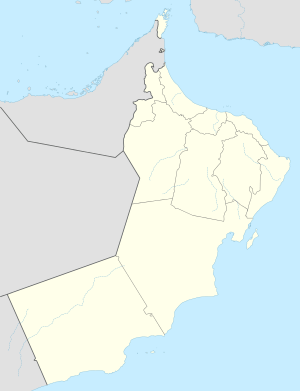 Khasab Location in Oman | |
| Coordinates: 26°11′N 56°15′E / 26.183°N 56.250°E | |
| Country |
|
| Governorate | Musandam Governorate |
| Population (2003) | |
| • Total | 17,730 |
| Time zone | +4 (UTC+4) |

Khasab (Arabic: خصب Ḫaṣab) is a city in an exclave of Oman bordering the United Arab Emirates. It is the local capital of the Musandam peninsula and has frequently been dubbed the "Norway of Arabia" because of its extensive fjord-like craggy inlets and desolate mountainscapes.[1][2][3][4]
History
The Portuguese built Khasab at the beginning of the 17th century, at the height of their naval presence in the region. The natural harbour gave shelter from rough seas. Unlike many forts, which were built on high ground for defensive purposes, Khasab was designed as a supply point for dates and water for Portuguese ships sailing through the strait. Today, Khasab is protected from floods by three large dams.[5]
Economy

Access to the area by land was virtually impossible until a modern coast road was built, which allows fast access from the United Arab Emirates, making Khasab a popular weekend destination for people living in the Emirates. The new road also allows access to the village of Tawi, where prehistoric drawings of boats, animals and warriors can be seen in the rock face.[5] Khasab also has a number of modern shopping areas with imported Irani goods and locally created pottery, and a few hotels, including the Khasab Hotel, Atana Musandam Resort and Atana Khasab Hotel, which sits on a cliff overlooking the Persian Gulf.[4]
Khasab has an interesting trading position, which hinges on its proximity to Iran. Iranians export sheep and goats into the local port, from where the animals are dispatched to the United Arab Emirates and Saudi Arabia in trucks. On their return trip to the Islamic Republic, the sailors load their boats up with electronic goods and American cigarettes, arriving in Khasab after sunrise and leave before sunset to conform with Omani immigration laws. Since the trading is illegal under Iranian law, they must avoid the Islamic Republic's coastguard as well as all other shipping in the busy waters of the Strait of Hormuz. The crossing is hazardous since the vessels, piled high either with livestock or with numerous boxes must avoid the path of the scores of oil-tankers which pass through the Strait in a transverse direction daily.[5] Recent increases of United States sanctions against Iran have increased the amount of smuggling done through Khasab.[6]
Telegraph Island
Boats from Khasab take tourists on trips to view the dolphins common in the waters around the Musandam, as well as to visit Telegraph Island, for a short time (between 1865 and 1868) the site of a manned telegraph repeater station on the cable section between Bahrain and Bombay.
Climate
Khasab has a hot desert climate (Köppen climate classification BWh) with very hot summers and mild winters. Precipitation is low, and mostly falls from December to March.
The Airport of Khasab, located few miles inland from the coast, on 27 June 2011, recorded the world calendar day highest minimum temperature of 41.2 °C (106.2 °F) until Death Valley, California, United States, broke the record by 0.5 °C (about 1 °F) on 12 July 2012.[7]
| Climate data for Khasab | |||||||||||||
|---|---|---|---|---|---|---|---|---|---|---|---|---|---|
| Month | Jan | Feb | Mar | Apr | May | Jun | Jul | Aug | Sep | Oct | Nov | Dec | Year |
| Record high °C (°F) | 30.8 (87.4) |
32.0 (89.6) |
37.5 (99.5) |
43.0 (109.4) |
46.2 (115.2) |
49.0 (120.2) |
47.7 (117.9) |
47.5 (117.5) |
44.0 (111.2) |
41.4 (106.5) |
36.0 (96.8) |
31.0 (87.8) |
49 (120.2) |
| Average high °C (°F) | 24.4 (75.9) |
24.9 (76.8) |
28.0 (82.4) |
33.5 (92.3) |
37.8 (100) |
39.2 (102.6) |
39.8 (103.6) |
38.6 (101.5) |
37.2 (99) |
34.5 (94.1) |
30.2 (86.4) |
25.9 (78.6) |
32.83 (91.1) |
| Daily mean °C (°F) | 20.2 (68.4) |
20.8 (69.4) |
23.8 (74.8) |
28.7 (83.7) |
32.8 (91) |
34.4 (93.9) |
35.3 (95.5) |
34.7 (94.5) |
33.1 (91.6) |
30.1 (86.2) |
25.7 (78.3) |
21.7 (71.1) |
28.44 (83.2) |
| Average low °C (°F) | 15.6 (60.1) |
16.2 (61.2) |
19.4 (66.9) |
23.9 (75) |
27.9 (82.2) |
30.0 (86) |
31.3 (88.3) |
31.1 (88) |
29.3 (84.7) |
25.5 (77.9) |
20.9 (69.6) |
17.3 (63.1) |
24.03 (75.25) |
| Record low °C (°F) | 10.5 (50.9) |
10.0 (50) |
10.0 (50) |
15.5 (59.9) |
21.5 (70.7) |
25.0 (77) |
23.8 (74.8) |
27.0 (80.6) |
22.0 (71.6) |
16.0 (60.8) |
12.0 (53.6) |
8.4 (47.1) |
8.4 (47.1) |
| Average precipitation mm (inches) | 44.8 (1.764) |
49.1 (1.933) |
46.3 (1.823) |
8.8 (0.346) |
1.9 (0.075) |
0.0 (0) |
0.8 (0.031) |
0.0 (0) |
0.0 (0) |
0.0 (0) |
2.9 (0.114) |
32.1 (1.264) |
186.7 (7.35) |
| Average relative humidity (%) | 63 | 66 | 62 | 53 | 60 | 63 | 66 | 70 | 69 | 63 | 61 | 62 | 63.2 |
| Source: NOAA (1961-1990) [8] | |||||||||||||
Gallery


 Indo-Pacific humpbacked dolphin off Khasab
References
| Wikimedia Commons has media related to Khasab. |
| Wikivoyage has a travel guide for Khasab. |
- ↑ Khasab, Oman Air. Retrieved November 11, 2009.
- ↑ Musandam is a glimpse of the real Arabia, Travel Weekly. Published September 28, 2006. Retrieved November 11, 2009.
- ↑ A Mountain Of Thirst, Outlook. Published February 2, 2004. Retrieved November 11, 2009.
- 1 2 Karim, Rose Yasmin. Fjords & flippers, The Star. Published February 21, 2009. Retrieved November 11, 2009.
- 1 2 3 Wells, Rhona. The Norway of Arabia, The Middle East. Published February 1, 2004. Retrieved November 11, 2009.
- ↑ al Shaibany, Saleb. US sanctions help Omani fishermen survive as smugglers, The National. Published November 1, 2009. Retrieved November 11, 2009.
- ↑ June 2011 Global Weather Extremes Summary , Weather Underground. Published September 8, 2011. Retrieved September 8, 2011
- ↑ "Khasab Climate Normals 1961-1990". National Oceanic and Atmospheric Administration. Retrieved January 15, 2013.
See also
|  | |||||||||||||||||||||||||||||||||||||||||||||||||||||||||||||||||||||||||
|
| ||||||||||||||||||||||||||||||||||||||||||||||||||||||||||||||||||||||||||
| ||||||||||||||||||||||||||||||||||||||||||||||||||||||||||||||||||||||||||
| ||||||||||||||||||||||||||||||||||||||||||||||||||||||||||||||||||||||||||
| ||||||||||||||||||||||||||||||||||||||||||||||||||||||||||||||||||||||||||
| ||||||||||||||||||||||||||||||||||||||||||||||||||||||||||||||||||||||||||
Coordinates: 26°11′N 56°15′E / 26.183°N 56.250°E