Kodungallur
| Kodungallur കൊടുങ്ങല്ലൂര് | |
|---|---|
| Municipal town | |
|
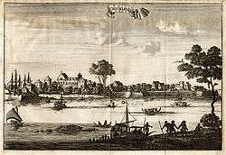
Dutch East India Company ships in Kodungallur (1708) | |
| Nickname(s): Muziris | |
 Kodungallur  Kodungallur | |
| Coordinates: 10°14′02″N 76°11′41″E / 10.233761°N 76.194634°ECoordinates: 10°14′02″N 76°11′41″E / 10.233761°N 76.194634°E | |
| Country | India |
| State | Kerala |
| District | Thrissur |
| Government | |
| • Body | Kodungallur Municipality |
| Area | |
| • Total | 28.96 km2 (11.18 sq mi) |
| Elevation | 9 m (30 ft) |
| Population (2011) | |
| • Total | 94,883 |
| • Density | 3,300/km2 (8,500/sq mi) |
| Languages | |
| • Official | Malayalam · English |
| • Spoken languages | Malayalam |
| Time zone | IST (UTC+5:30) |
| PIN | 680664 |
| Telephone code | 0480 |
| Vehicle registration | KL-8 / KL 47 |
Kodungallur (anglicised name: Cranganore), is a municipality in the South Western border of Thrissur district of Kerala, India. Kodungallur is 29 kilometres (18 mi) northwest of Kochi and 38 kilometres (24 mi) southwest of Thrissur, by National Highway 66 (formerly known as NH 17).
History
It is postulated that the ancient city of Muziris( Muchiripattinam,Mahodayapuram/Vanchi) was devastated by natural calamities—a flood or an earth quake—in 1341, and consequently lost its commercial importance thereafter.[1] Further, it came under military attacks on various occasions: in 1504 by the Portuguese-Kochi allied forces during their movement against Calicut in 1524, by the Mappilas during their attack against the Portuguese, and in 1565 again by the Portuguese.
Notable landmarks
The area contains several historical and religious sites of note:
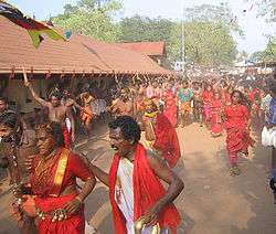
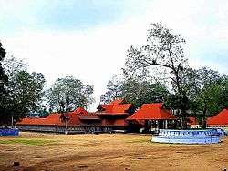
- Kodungallur Bhagavathy Temple is believed to have been constructed during the reign of Chera King, Cheran Senkuttuvan. It is famous for its Bharani and Thalappoli festival. The temple requires the pilgrim to carry pepper and turmeric powder as one of the offerings to the deity. The Bharani festival at the Kodungallur Bhagawati temple is a month of festivities of the Bharani asterism in the month of Aquarius to seven days after the Bharani asterism in the month of Pisces. Traditionally, the temple (especially during the Bharani festival) has been associated with animal sacrifices. The blood of the sacrificed used to be spilled over two stones in the prakaram(closed precincts of a temple), but these customs have been abolished in the 20th century. William Logan, a social historian of Kerala, noted in 1887 that Kodungallur Bharani could have been the most important celebration in Kerala if Onam, the national festival of Kerala, was excused.
- Cheraman Juma Masjid was built around 629 A.D. by Malik Ibn Dinar in the typical local style of architecture and the bodies of some of the original followers are said to have been buried here. This is said to be the first mosque constructed in India.
- The apostle St Thomas is believed to have landed in Kodungallur in 52 A.D. He established Mar Thoma Syro-Malabar Catholic Church, which is believed to be the first Christian church in India. It still houses ancient relics which are displayed to visitors at certain times.[2]
- Thiruvanchikulam Mahadeva Temple is one of the oldest Shiva temples in South India, where Lord Shiva is said to have lived along with his whole family. This temple has a relation to Tamil Nadu's famous Chidambaram temple. This temple has another rare event called "Anayottam" (elephant race) which is part of the annual festival. Lord Shiva of the Thiruvanchikulam temple is the family god of Cochin Royal Family (Perumpadapu Swaroopam). Thiruvanchikulam temple has the oldest reference in history in old Tamil Sangam literature, well before Malayalam was formed.
- Edavilangu sivakrishnapuram Temple is one of the oldest temples in Kodungallur. It is currently under the Cochin Devaswom Board, but is now looked after by the devotees of Edavilangu. Here, Lord Siva and Krishna are the main idols.
- Cranganore Fort, also known as Kodungallur Fort, was built by the Portuguese in 1523. The Dutch took possession of it in 1661 and later it came under the control of Tipu Sultan. The ruin is also known as Tipu Sultan’s fort. The fort is about 2 km from the town of Kodungallur.[3]
- Chirakkal Kovilakam is the palace of Royal Family of Kodungallur. Kodungallur was an autonomous principality subordinate to the Raja of Cochin until India's Independence in 1947. Puthen Kovilakam, a well-known centre of learning, is attached to this palace.
Demographics
As of 2011 India census,[4] Kodungallur municipality had a population of 94,883: males constitute 47% of the population and females 53%, while 10% of the total population was under 6 years of age. The municipality had an average literacy rate of 85%: male literacy is 85.58% and female literacy is 85.00%.
Local government
Kodungallur Municipality was formed in the year 1978. It covers an area of 28.96 km2 and is divided into 44 electoral wards. The Municipality has a total population of 94,883 with a density of 1,806 per km2 as per the 2011 Census. Kodungallur is the headquarters of the Kodungallur Taluk and is a Grade-II Municipality. [5] Kodungallur assembly constituency is part of Chalakudi (Lok Sabha constituency).[6]
References
- ↑ Ashis Nandy (1 January 2002). Time Warps: Silent and Evasive Pasts in Indian Politics and Religion. Hurst. pp. 172–. ISBN 978-1-85065-479-7. Retrieved 28 August 2012.
- ↑ Menachery,Kodungallur...1987, reprint 2000
- ↑ "Kodungallur". Kerala Tourism. Retrieved 2010-10-15.
- ↑ "Census of India 2001: Data from the 2011 Census, including cities, villages and towns (Provisional)". Census Commission of India. Archived from the original on 2004-06-16. Retrieved 2008-11-01.
- ↑ "Profile". Janasevana Kendram. Retrieved 2010-12-07.
- ↑ "Assembly Constituencies – Corresponding Districts and Parliamentary Constituencies" (PDF). Kerala. Election Commission of India. Retrieved 2008-10-19.
![]() This article incorporates text from a publication now in the public domain: Chisholm, Hugh, ed. (1911). "article name needed". Encyclopædia Britannica (11th ed.). Cambridge University Press.
This article incorporates text from a publication now in the public domain: Chisholm, Hugh, ed. (1911). "article name needed". Encyclopædia Britannica (11th ed.). Cambridge University Press.
External links
| Wikimedia Commons has media related to Kodungallur. |
| Wikisource has the text of the 1911 Encyclopædia Britannica article Kodungalur. |
|  | |||||||||||||||||||||||||||||||||||||||||||||||||||||||||||||||||||||||||
|
| ||||||||||||||||||||||||||||||||||||||||||||||||||||||||||||||||||||||||||
| ||||||||||||||||||||||||||||||||||||||||||||||||||||||||||||||||||||||||||
| ||||||||||||||||||||||||||||||||||||||||||||||||||||||||||||||||||||||||||
| ||||||||||||||||||||||||||||||||||||||||||||||||||||||||||||||||||||||||||
| ||||||||||||||||||||||||||||||||||||||||||||||||||||||||||||||||||||||||||