Tangier
| Tangier طنجة / Tingi / ⵜⵉⵏⴳⵉ Ṭanja / Tingis / Tangiers | |||
|---|---|---|---|
| Tanger | |||
|
Tangier | |||
| |||
| Nickname(s): The Blue and White city, Boughaz, The north's bride. | |||
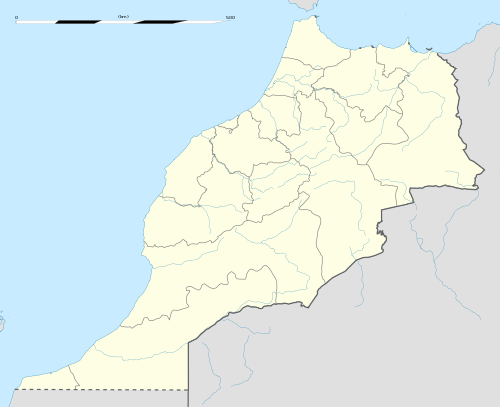 Tangier Location in Morocco | |||
| Coordinates: 35°46′N 5°48′W / 35.767°N 5.800°W | |||
| Country |
| ||
| Region | Tanger-Tetouan-Al Hoceima | ||
| Highest elevation | 230 m (750 ft) | ||
| Lowest elevation | 0 m (0 ft) | ||
| Population (2014) | |||
| • Total | 947,952 | ||
| • Rank | 3rd in Morocco | ||
| Demonym(s) | Tangerian, Tangeriana | ||
| Time zone | GMT 0 | ||
| Postal code | 90000 | ||


.jpg)
Tangier (/tænˈdʒɪər/; Arabic: طنجة Ṭanjah; Berber: Ṭanja; old Berber name: Tingi, ⵜⵉⵏⴳⵉ; adapted to Roman: Tingis; other English name: Tangiers) is a major city in northwestern Morocco. It is located on the Maghreb coast at the western entrance to the Strait of Gibraltar, where the Mediterranean Sea meets the Atlantic Ocean off Cape Spartel. It is the capital of the Tanger-Tetouan-Al Hoceima region, as well as the Tangier-Assilah prefecture of Morocco.
The history of Tangier is very rich, due to the historical presence of many civilizations and cultures starting from before the 5th century BC. Between the period of being a strategic Berber town and then a Phoenician trading center to the independence era around the 1950s, Tangier was a nexus for many cultures. In 1923, it was considered as having international status by foreign colonial powers, and became a destination for many European and American diplomats, spies, writers and businessmen.
The city is currently undergoing rapid development and modernization. Projects include new tourism projects along the bay, a modern business district called Tangier City Center, a new airport terminal and a new football stadium. Tangier's economy is also set to benefit greatly from the new Tanger-Med port.
Etymology
The city's name is said to come from Tingis, the daughter of Atlas, the mythical supporter of the Heavens. However, it more likely derives from the Semitic word tigisis, meaning "harbour".[1] Tangier is also referred to as Boughaz or nicknamed as "the bride of the north" by the Moroccans and "the door of Africa" for its particular location in the peak of the continent.
History

Tangier was founded by in the early 5th century BCE Carthaginian colonists, who were probably the first ones to settle around the coast.
The Greeks ascribed the city's establishment to the giant Antaios, whose tomb and skeleton are pointed out in the vicinity, calling Sufax the son of Hercules by the widow of Antaeus. The cave of Hercules, a few miles from the city, is a major tourist attraction. It is believed that Hercules slept there before attempting one of his twelve labours.
The commercial town of Tingi (Τιγγίς in Ancient Greek) came under Roman rule during the 2nd century BC (146 BC). It was initially autonomous, and then, under Augustus, became a colony (Colonia Julia, under Claudius) and capital of Mauritania Tingitana of Hispania (since 38 BC). It was the scene of the martyrdoms of Saint Marcellus of Tangier. Tingis was the main Roman city of Mauretania Tingitana in the fourth century and enjoyed huge development and importance. In the 5th century AD, Vandals conquered and occupied "Tingi" and from here swept across the Maghreb.
A century later (between 534 and 682), Tangier fell to the Byzantine Empire, before coming under the control of the Umayyad Caliphate in 702. Due to its Christian past, it is still a titular see of the Roman Catholic Church.[2] When the Portuguese, driven in good part by religious fervor, started their colonial expansion by taking Ceuta in 1415,[3] Tangier was always a primary goal. They failed to capture the city in 1437 but finally occupied it in 1471 (see List of colonial heads of Tangier). A partial plan of the original kasbah (Arabic: القصبة al-qaṣbah) was found in 2009–12, in a Portuguese document now preserved in the Military Archives of Sweden in Stockholm (Krigsarkivet (Riksarkivet)).[4] The Portuguese rule lasted until 1662, when it was given to Charles II of England as part of the dowry from the Portuguese Infanta Catherine of Braganza, becoming English Tangier.[5] The English gave the city a garrison and a charter which made it equal to English towns. The English planned to improve the harbour by building a mole. With an improved harbour the town would have played the same role that Gibraltar later played in British naval strategy. The mole cost £340,000 and reached 1,436 feet (438 m) long, before being blown up during the evacuation.[6]
An attempt of Sultan Moulay Ismail of Morocco to seize the town in 1679 was unsuccessful; but a crippling blockade by his Jaysh al-Rifi ultimately forced the English to withdraw. The English destroyed the town and its port facilities prior to their departure in 1684. Under Moulay Ismail the city was reconstructed to some extent, but it gradually declined until, by 1810, the population was no more than 5,000.
The United States dedicated its first consulate in Tangier during the George Washington administration.[7] In 1821, the Legation Building in Tangier became the first piece of property acquired abroad by the U.S. government—a gift to the U.S. from Sultan Moulay Suliman. In 1828, Great Britain blockaded the port in retaliation for piracy.[8] It was bombarded by the French Prince of Joinville in 1844.
Italian revolutionary hero Giuseppe Garibaldi lived in exile at Tangier in late 1849 and the first half of 1850, following the fall of the revolutionary Roman Republic.
Tangier's geographic location made it a centre for European diplomatic and commercial rivalry in Morocco in the late 19th and early 20th centuries.[9] By the opening of the 20th century, it had a population of about 40,000, including 20,000 Muslims, 10,000 Jews, and 9,000 Europeans (of whom 7,500 were Spanish). The city was increasingly coming under French influence, and it was here in 1905 that Kaiser Wilhelm II triggered an international crisis that almost led to war between his country and France by pronouncing himself in favour of Morocco's continued independence.
In 1912, Morocco was effectively partitioned between France and Spain, the latter occupying the country's far north and far south, while France declared a protectorate over the remainder. The last Sultan of independent Morocco, Moulay Hafid, was exiled to the Sultanate Palace in the Tangier Kasbah after his forced abdication in favour of his brother Moulay Yusef. Tangier was made an international zone in 1923 under the joint administration of France, Spain, and Britain under an international convention signed in Paris on December 18, 1923. Ratifications were exchanged in Paris on May 14, 1924. The convention was registered in League of Nations Treaty Series on September 13, 1924.[10] The convention was amended in 1928.[11] The governments of Italy, Portugal and Belgium adhered to the convention in 1928, and the government of the Netherlands in 1929.

The International zone of Tangier had a 373 square kilometer area and, by 1939, a population of about 60,000 inhabitants.[12]
Spanish troops occupied Tangier on June 14, 1940, the same day Paris fell to the Germans. Despite calls by the writer Rafael Sánchez Mazas and other Spanish nationalists to annex "Tánger español", the Franco regime publicly considered the occupation a temporary wartime measure.[13] A diplomatic dispute between Britain and Spain over the latter's abolition of the city's international institutions in November 1940 led to a further guarantee of British rights and a Spanish promise not to fortify the area.[14] The territory was restored to its pre-war status on October 11, 1945.[15] Pre-1956 Tangier had a population of 40,000 Muslims, 31,000 Europeans and 15,000 Jews.[16] Tangier joined with the rest of Morocco following the restoration of full sovereignty in 1956.
Ecclesiastical history
Originally, the city was part of the larger province of Mauretania Caesariensis, which included much of Northern Africa. Later the area was subdivided, with the eastern part keeping the former name and the newer part receiving the name of Mauretania Tingitana. It is not known exactly at what period there may have been an episcopal see at Tangier in ancient times, but in the Middle Ages Tangier was used as a titular see (i.e., an honorific fiction for the appointment of curial and auxiliary bishops), placing it in Mauretania Tingitana. For the historical reasons given above, one official list of the Roman Curia places the see in Mauretania Caesarea.
Towards the end of the 3rd century, Tangier was the scene of the martyrdom of Saint Marcellus of Tangier, mentioned in the Roman Martyrology on 30 October, and of St. Cassian, mentioned on 3 December.
Under the Portuguese domination, there was a Bishop of Tangier who was a suffragan of the diocese of Lisbon but in 1570 the diocese was united to the diocese of Ceuta. Six Bishops of Tangier from this period are known, the first, who did not reside in his see, in 1468. During the era of the protectorate over Morocco, Tangier was the residence of the Prefect Apostolic of Morocco, the mission having been founded on November 28, 1630, and entrusted to the Friars Minor. At the time it had a Catholic church, several chapels, schools, and a hospital. The Prefecture Apostolic was raised to the status of a Vicariate Apostolic of Marocco April 14, 1908, and on November 14, 1956, became the Archdiocese of Tangier.[17]
The city also has the Anglican church of Saint Andrew.
Espionage
Tangier has been reputed as a safe house for international spying activities.[18] Its position during the Cold War and during other spying periods of the 19th and 20th centuries is legendary.
Tangier acquired the reputation of a spying and smuggling centre and attracted foreign capital due to political neutrality and commercial liberty at that time. It was via a British bank in Tangier that the Bank of England in 1943 for the first time obtained samples of the high-quality forged British currency produced by the Nazis in "Operation Bernhard".
The city has also been a subject for many spy fiction books and films (see Tangier in popular culture below).
Climate
Tangier has a mediterranean climate (Köppen Csa) with heavier rainfall than most parts of North Africa and nearby areas on the Iberian Peninsula owing to its exposed location. The summers are relatively hot and sunny and the winters are wet and mild: frost is rare, however in January 2005 a low of −4.2 °C was recorded. [19]
| Climate data for Tangier (Tangier Airport) 1961–1990, extremes 1961–present | |||||||||||||
|---|---|---|---|---|---|---|---|---|---|---|---|---|---|
| Month | Jan | Feb | Mar | Apr | May | Jun | Jul | Aug | Sep | Oct | Nov | Dec | Year |
| Record high °C (°F) | 22.0 (71.6) |
27.0 (80.6) |
25.0 (77) |
27.0 (80.6) |
34.0 (93.2) |
36.0 (96.8) |
41.0 (105.8) |
39.0 (102.2) |
39.5 (103.1) |
30.0 (86) |
27.0 (80.6) |
24.5 (76.1) |
41.0 (105.8) |
| Average high °C (°F) | 16.2 (61.2) |
16.8 (62.2) |
17.9 (64.2) |
19.2 (66.6) |
21.9 (71.4) |
24.9 (76.8) |
28.3 (82.9) |
28.6 (83.5) |
27.3 (81.1) |
23.7 (74.7) |
19.6 (67.3) |
17.0 (62.6) |
21.8 (71.2) |
| Daily mean °C (°F) | 12.5 (54.5) |
13.1 (55.6) |
14.0 (57.2) |
15.2 (59.4) |
17.7 (63.9) |
20.6 (69.1) |
23.5 (74.3) |
23.9 (75) |
22.8 (73) |
19.7 (67.5) |
15.9 (60.6) |
13.3 (55.9) |
17.7 (63.9) |
| Average low °C (°F) | 8.8 (47.8) |
9.4 (48.9) |
10.1 (50.2) |
11.2 (52.2) |
13.4 (56.1) |
16.2 (61.2) |
18.7 (65.7) |
19.1 (66.4) |
18.3 (64.9) |
15.6 (60.1) |
12.2 (54) |
9.7 (49.5) |
13.6 (56.5) |
| Record low °C (°F) | −4.2 (24.4) |
1.0 (33.8) |
3.5 (38.3) |
1.0 (33.8) |
7.0 (44.6) |
10.0 (50) |
11.0 (51.8) |
11.0 (51.8) |
10.0 (50) |
7.0 (44.6) |
3.0 (37.4) |
4.0 (39.2) |
−4.2 (24.4) |
| Average precipitation mm (inches) | 103.5 (4.075) |
98.7 (3.886) |
71.8 (2.827) |
62.2 (2.449) |
37.3 (1.469) |
13.9 (0.547) |
2.1 (0.083) |
2.5 (0.098) |
14.9 (0.587) |
65.1 (2.563) |
134.6 (5.299) |
129.3 (5.091) |
735.9 (28.972) |
| Average precipitation days | 11.2 | 11.4 | 10.1 | 9.3 | 6.1 | 3.7 | 0.8 | 0.8 | 3.1 | 8.0 | 11.1 | 12.0 | 87.6 |
| Average relative humidity (%) | 80 | 81 | 78 | 78 | 76 | 74 | 70 | 72 | 73 | 76 | 79 | 81 | 76 |
| Mean monthly sunshine hours | 169.2 | 166.9 | 231.7 | 251.7 | 298.9 | 306.8 | 344.0 | 330.7 | 275.6 | 238.2 | 180.6 | 166.9 | 2,960.7 |
| Source #1: NOAA[20] | |||||||||||||
| Source #2: Deutscher Wetterdienst (humidity, 1973–1993)[21] Meteo Climat (record highs and lows)[22] | |||||||||||||
Subdivisions
The prefecture is divided administratively into the following:[23]
| Name | Geographic code | Type | Households | Population (2004) | Foreign population | Moroccan population | Notes |
|---|---|---|---|---|---|---|---|
| Assilah | 511.01.01. | Municipality | 6245 | 28217 | 66 | 28151 | |
| Bni Makada | 511.01.03. | Arrondissement | 47384 | 238382 | 74 | 238308 | |
| Charf-Mghogha | 511.01.05. | Arrondissement | 30036 | 141987 | 342 | 141645 | |
| Charf-Souani | 511.01.06. | Arrondissement | 25948 | 115839 | 273 | 115566 | |
| Tanger-Medina | 511.01.07. | Arrondissement | 40929 | 173477 | 2323 | 171154 | |
| Al Manzla | 511.03.01. | Rural commune | 555 | 3031 | 0 | 3031 | |
| Aquouass Briech | 511.03.03. | Rural commune | 787 | 4132 | 3 | 4129 | |
| Azzinate | 511.03.05. | Rural commune | 920 | 4895 | 0 | 4895 | |
| Dar Chaoui | 511.03.07. | Rural commune | 877 | 4495 | 0 | 4495 | 1424 residents live in the center, called Dar Chaoui; 3071 residents live in rural areas. |
| Lkhaloua | 511.03.09. | Rural commune | 2405 | 12946 | 1 | 12945 | |
| Sahel Chamali | 511.03.11. | Rural commune | 1087 | 5588 | 2 | 5586 | |
| Sidi Lyamani | 511.03.13. | Rural commune | 1883 | 10895 | 1 | 10894 | 1101 residents live in the center, called Sidi Lyamani; 9794 residents live in rural areas. |
| Boukhalef | 511.81.03. | Rural commune | 3657 | 18699 | 4 | 18695 | 3187 residents live in the center, called Gueznaia; 15512 residents live in rural areas. |
Culture

The multicultural placement of Muslim, Christian, and Jewish communities and the foreign immigrants attracted writer and composer Paul Bowles, playwright Tennessee Williams, the beat writers William S. Burroughs, Allen Ginsberg and Jack Kerouac, the painter Brion Gysin and the music group the Rolling Stones, who all lived in or visited Tangier during different periods of the 20th century.
The writer George Orwell and his wife (travelling as Mr. & Mrs. Blair) visited Tangier in September, 1938. Orwell reported newspapers on sale: "La Press Morocain, strongly pro-Franco; Le Petite Morocain, impartial; La Dépêche Morocain, somewhat pro-Franco; Le Journal De Tanger, seemingly non-political; Tangier Gazette & Morocco Mail, an English weekly, slightly antifascist and strongly anti-Japanese." He also noted "There are four post offices, one French, one British, and two Spanish – Franco and government. Stamps are British surcharged Tangier. Coinage as in French Morocco."[24]
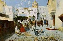
It was after Delacroix that Tangier became an obligatory stop for artists seeking to experience the colors and light he spoke of for themselves—with varying results. Matisse made several sojourns in Tangier, always staying at the Grand Hotel Villa de France. "I have found landscapes in Morocco," he claimed, "exactly as they are described in Delacroix's paintings." The Californian artist Richard Diebenkorn was directly influenced by the haunting colors and rhythmic patterns of Matisse's Morocco paintings.
Antonio Fuentes was born in Tangier in 1905 from a Spanish family. An article in La Gazette du Maroc described Antonio Fuentes as the Picasso of Tangier,[25] and he died in the city 90 years later.[26]
In the 1940s and until 1956 when the city was an International Zone, the city served as a playground for eccentric millionaires, a meeting place for secret agents and all kinds of crooks, and a mecca for speculators and gamblers, an Eldorado for the fun-loving "Haute Volée". During World War II the Office of Strategic Services operated out of Tangier for various operations in North Africa.[27]
Around the same time, a circle of writers emerged which was to have a profound and lasting literary influence. This included Paul Bowles, who lived and wrote for over half a century in the city, Tennessee Williams and Jean Genet as well as Mohamed Choukri (one of North Africa's most controversial and widely read authors), Abdeslam Boulaich, Larbi Layachi, Mohammed Mrabet and Ahmed Yacoubi. Among the best known works from this period is Choukri's For Bread Alone. Originally written in Classical Arabic, the English edition was the result of close collaboration with Bowles (who worked with Choukri to provide the translation and supplied the introduction). Tennessee Williams described it as "a true document of human desperation, shattering in its impact." Independently, William S. Burroughs lived in Tangier for four years and wrote Naked Lunch, whose locale of Interzone is an allusion to the city.
After several years of gradual disentanglement from Spanish and French colonial control, Morocco reintegrated the city of Tangier at the signing of the Tangier Protocol on October 29, 1956. Tangier remains a very popular tourist destination for cruise ships and day visitors from Spain and Gibraltar.
Sport
I.R.T. (or Ittihad Riadi de Tanger) is a football club. Tangier would be one of the host cities for the 2015 Africa Cup of Nations football tournament, which would be played at the new Ibn Batouta Stadium and in other cities across Morocco, until Morocco was banned from participating the Africa Cup of Nations due to their denial.[28]
National Cricket Stadium is the only top-class cricket stadium in Morocco. Stadium hosted its first International Tournament from 12 to 21 August 2002. Pakistan, South Africa and Sri Lanka competed in a 50-overs one day triangular series.
The International Cricket Council has granted international status to the Tangier Cricket Stadium, official approval that will allow it to become North Africa's first international cricket venue.
Economy


Tangier is Morocco's second most important industrial centre after Casablanca. The industrial sectors are diversified: textile, chemical, mechanical, metallurgical and naval. Currently, the city has four industrial parks of which two have the status of free economic zone (see Tangier Free Zone).
Tangier's economy relies heavily on tourism. Seaside resorts have been increasing with projects funded by foreign investments. Real estate and construction companies have been investing heavily in tourist infrastructures. A bay delimiting the city centre extends for more than 7 kilometres (4 miles). The years 2007 and 2008 were particularly important for the city because of the completion of large construction projects; These include the Tangier-Mediterranean port ("Tanger-Med") and its industrial parks, a 45,000-seat sports stadium, an expanded business district, and a renovated tourist infrastructure.
Tangier Med, a new port 40 kilometers outside the traditional Tangier city, began construction in 2004 and become functional in 2007. Its site plays a key role in connecting maritime regions, as it is in a very critical position on the Strait of Gibraltar, which passes between Europe and Africa. The makeup of the new port is 85% transhipment 15% for domestic import and export activities.[29] The port is distinguished by its size, infrastructure, and efficiency in managing the flow of ships. Tangier Med has linked Morocco to Europe’s freight industry. It has also helped connect Morocco to countries in the Mediterranean, Africa, and America. The port has allowed Tangier to become a more globalized city with new international opportunities that will help facilitate economic growth.[30] The construction and operation of the port aimed to create 120,000 new jobs, 20,000 at the port and 100,000 resulting from growing economic activity.
Agriculture in the area of Tangier is tertiary and mainly cereal.
The infrastructure of this city on the strait of Gibraltar consists of a port that manages flows of goods and travellers (more than one million travellers per annum) and integrates a marina with a fishing port.
Artisanal trade in the old medina (old city) specializes mainly in leather working, handicrafts made from wood and silver, traditional clothing, and shoes of Moroccan origin.
The city has seen a fast pace of rural exodus from other small cities and villages. Today's population is more than three-times larger than 32 years ago (850.000 inhabitants in 2014 vs. 250,000 in 1982). This phenomenon has resulted in the appearance of peripheral suburban districts, mainly inhabited by poor people, that often lack sufficient infrastructure.
Notable landmarks


- Dar el Makhzen (Sultan's palace)
- Ancien Palais du Mendoub
- Perdicaris Parc Named after the notable Ion H. Percifaris (Greek-American communitist of Tangiers).
- Sidi Bou Abib Mosque
- Tangier Grand Mosque
- Church of the Immaculate Conception
- Anglican Church of St. Andrew
- Plaza de Toros (bullring arena) on Rue de Tetouan
- Gran Teatro Cervantes
- Tangier American Legation Museum
- Museum of Moroccan Arts and Antiquities
- Museum of Contemporary Art
- Fondation Lorin
- Musée de Carmen-Macein
- Grand Socco souk and square
- Petit Socco souk
- Casabarata souk or giant flea market
- Hotel Continental
- Rue Es-Siaghine
- Rue de la Liberté
- Avenue Pasteur
- Avenue Mohammed VI beach
- Parc de la Mendoubia
- Quartier du Marshan
- Colline du Charf
- Café Hafa
Transport
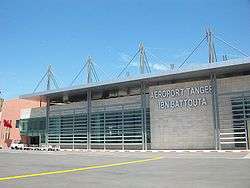
A railway line connects the Tangier area with Rabat, Casablanca and Marrakesh in the south, and with Fes and Oujda in the east. The service is operated by ONCF. The Rabat–Tangier expressway connects Tangier to Fès via Rabat 250 kilometres (155 miles), and Settat via Casablanca 330 km (205 mi) and Tanger-Med port. The Ibn Batouta International Airport (formerly known as Tangier-Boukhalef) is located 15 km (9 mi) south-west of the city centre.
The new Tanger-Med Port is managed by the Danish firm A. P. Moller–Maersk Group and will free up the old port for tourist and recreational development.
Tangier's Ibn Batouta International Airport and the rail tunnel will serve as the gateway to the Moroccan Riviera, the littoral area between Tangier and Oujda. Traditionally, the northern coast was a rural stronghold, with some of the best beaches on the Mediterranean. It is slated for rapid urban development. The Ibn Batouta International Airport has been modernized to accommodate more flights. The biggest airline at the airport is Royal Air Maroc. In addition, a TGV high-speed train system is being built. It will take a few years to complete, and will become the fastest train system in the Maghreb.
Language
Most of the inhabitants of Tangier speak the Darija, mainly influenced by Spanish. About 25% of the city inhabitants speak Berber in their daily lives. Tangerian, as the residents refer to their language, is different from the rest of Morocco, with a lexicon derived from Berber, Spanish, English, and old Tangerian words. Written Arabic is used in government documentation and on road signs together with French. French is used in universities and large businesses. English and Spanish are well understood in all hotels and tourist areas.
Education

Tangier offers four types of education systems: Arabic, French, Spanish and English. Each offers classes starting from pre-Kindergarten up to the 12th grade,as for German in the three last years of high school. The Baccalaureat, or high school diploma are the diplomas offered after clearing the 12 grades.
Many universities are inside and outside the city. Universities like the Institut Superieur International de Tourisme (ISIT), which grants diplomas, offer courses ranging from business administration to hotel management. The institute is one of the most prestigious tourism schools in the country. Other colleges such as the École Nationale de Commerce et de Gestion (ENCG-T) is among the biggest business schools in the country as well as École Nationale des Sciences appliquées (ENSA-T), a rising engineering school for applied sciences. University known as Abdelmaled Essaadi holding many what they mainly known as faculties; Law, Economics and Social sciences (FSJEST) and the FST of Technical Sciences. and the most attended Institut of ISTA of the OFPPT.
Primary education
There are more than a hundred Moroccan primary schools, dispersed across the city. Private and public schools, they offer education in Arabic, French and some school English until the 5th grade. Mathematics, Arts, Science Activities and nonreligious modules are commonly taught in the primary school.
International primary institutions
- The American School of Tangier
- École Adrien Berchet (French primary school)
- Groupe scolaire Le Détroit (French school)
- Colegio Ramón y Cajal (Spanish primary school)
- English College of Tangier
- Tangier Anglo Moroccan School
International high schools
- The American School of Tangier
- Lycée Regnault de Tanger (French high school)
- Groupe scolaire Le Détroit (French school)
- Instituto Español Severo Ochoa (Spanish high school)
- English College of Tangier
- Mohammed Fatih Turkish School of Tangier
- Tangier Anglo Moroccan School
In popular culture
Notable people
- Yasser Harrak – Writer and human rights activist.
- Ibn Battuta – Moroccan scholar and traveler who went on a worldwide quest.
- Ralph Benmergui – Canadian TV and radio host at the Canadian Broadcasting Corporation
- Paul Bowles – American writer, composer and ethnomusicologist
- William S. Burroughs – Beat Generation Writer, wrote Naked Lunch during the 1950s in Tangier.
- Alexandre Rey Colaço – Portuguese pianist
- Ion Perdicaris – Greek-American became the unofficial head of Tangier's foreign community
- Karim Debbagh – Moroccan Film producer
- Roger Elliott – first British Governor of Gibraltar
- Antonio Fuentes – Painter described as the 'Picasso of Tangier'[1]
- Abdullah al-Ghumari – Muslim cleric
- Sanaa Hamri – Moroccan music video director.
- Emmanuel Hocquard – French poet
- Jean-Luc Mélenchon – French politician, currently MEP
- Claude-Jean Philippe – French film critic
- Alexander Spotswood – American Lieutenant-Colonel and Lieutenant Governor of Virginia
- Heinz Tietjen – German music composer
- Abderrahmane Youssoufi – former Prime Minister of Morocco
- Ahmed Yacoubi – international painter extraordinaire
Twin towns – sister cities
Tangier is twinned with:
See also
- History of Morocco
- List of cities in Morocco
- List of Colonial Heads of Tangier
- Mauretania Tingitana
- Tingis
- English Tangier
- Tangier International Zone
Notes
- ↑ "Tangier". Online Etymology Dictionary.
- ↑
 Herbermann, Charles, ed. (1913). "Tingis". Catholic Encyclopedia. New York: Robert Appleton Company.
 - ↑ B. W. Diffie, Prelude to Empire, Portugal Overseas before Henry the Navigator, University of Nebraska Press, Ann Arbor, 1960, pp. 83–90.
- ↑ Martin Malcolm Elbl, "Tangier's Qasba Before the Trace Italienne Citadel of 1558–1566: The 'Virtual' Archaeology of a Vanished Islamic and Portuguese Fortress," Portuguese Studies Review 17 (2) (2009; publ. 2012): 1–44.
- ↑ Winston S. Churchill, Marlborough: His Life and Times, Book I (University of Chicago Press: Chicago, 1933) p. 35.
- ↑ Enid M. G. Routh — Tangier: England's lost Atlantic outpost, 1912; Martin Malcolm Elbl, "(Re)claiming Walls: The Fortified Médina of Tangier under Portuguese Rule (1471–1661) and as a Modern Heritage Artefact," Portuguese Studies Review 15 (1–2) (2007; publ. 2009): 103–192; a long study of the previous Portuguese Breakwater at Tangier, and interesting notes on the English Mole and its contractors are found in Elbl, Portuguese Tangier, Chapter Eight.
- ↑ Power, Faith, and Fantasy: In the beginning, for America, was the Middle East, Matt Buckingham, Wweek, February 14, 2007.
- ↑ "'Abd ar-Rasham". Encyclopædia Britannica. I: A-Ak – Bayes (15th ed.). Chicago, IL: Encyclopædia Britannica, Inc. 2010. p. 17. ISBN 978-1-59339-837-8.
- ↑ Bensoussan, David (2010). Il Était Une Fois Le Maroc: Témoignages Du Passé Judéo-Marocain (in French). Québec: Éditions Du Lys. ISBN 978-2-922505-21-4.
- ↑ League of Nations Treaty Series, vol. 28, pp. 542–631.
- ↑ Text in League on Nations Treaty Series, vol. 87, pp. 212–251.
- ↑ "City states". Retrieved 2008-09-21.
- ↑ Payne, S.G. The Franco Regime, 1936–1975. Madison: University of Wisconsin, 1987. 268.
- ↑ Payne 1987, p. 274, note 28.
- ↑ Benton, Assistant Secretary (October 21, 1945). "Reestablishment of the International Regime in Tangier". Department of State Bulletin. 330. XIII: 613–618.
- ↑ "Tangier(s)". Jewish Virtual Library. Archived from the original on January 18, 2012.
- ↑ Annuario Pontificio 2010, p. 721
- ↑ Pennell, C. R. (1999). "Wars: The second World War in Morocco". Morocco since 1830: A History. New York University Press. p. 257. ISBN 1-85065-426-3.
- ↑ http://ogimet.com/cgi-bin/gsynres?lang=en&ind=60101&ano=2005&mes=1&day=28&hora=18&min=0&ndays=30
- ↑ "Tangier Climate Normals 1961–1990". National Oceanic and Atmospheric Administration. Retrieved October 14, 2016.
- ↑ "Klimatafel von Tanger / Marokko" (PDF). Baseline climate means (1961–1990) from stations all over the world (in German). Deutscher Wetterdienst. Retrieved October 14, 2016.
- ↑ "Station Tangier Airport" (in French). Météo Climat. Retrieved October 14, 2016.
- ↑ "Recensement général de la population et de l'habitat de 2004" (PDF). Haut-commissariat au Plan, Lavieeco.com. Retrieved 27 April 2012.
- ↑ George Orwell Diaries. W.W. Norton & Co. 2012. pp. 93–94. ISBN 978-0-87140-410-7.
- ↑ La Gazette Du Maroc. La Gazette Du Maroc. Retrieved on 2011-06-04.
- ↑ www.antoniofuentes.org. www.antoniofuentes.org. Retrieved on 2011-06-04.
- ↑ The American Legation at Tangier, Morocco Archived January 24, 2008, at the Wayback Machine.
- ↑ Morocco then South Africa to host Cups. FIFA.com (2011-01-29). Retrieved on 2011-06-04.
- ↑ César Ducruet, Fatima Mohamed-Chérif, Najib Cherfaoui. Maghreb Port Cities in Transition: The Case of Tangier (n.d.): n. pag. Web.
- ↑ Ouail El Im Rani Et Al., International Journal Of Research In Management, Economics And Commerce,, and Issn 2250-057X, Impact Factor: 6.384, Vo Lu Me 06 Issue 07, July 2016, Page 73-81. Tangier Med Port: What Role for the Moroccan Economy and the International Trade? (n.d.): n. pag. Web.
- ↑ "Geminações de Cidades e Vilas". Associação Nacional de Municípios Portugueses (in Portuguese). Retrieved 2013-07-20.
External links
| Wikimedia Commons has media related to Tangier. |
| Wikisource has the text of The New Student's Reference Work article Tangier. |
| Wikivoyage has a travel guide for Tangier. |
- Official site of The Tangier American Legation Institute for Moroccan Studies
- Travel article with photos
- History, description, and images of Tangier on Archnet
- Tangier photo gallery
- Navigating Tangier's Labyrinth – slideshow by The New York Times
- "Tangier". Islamic Cultural Heritage Database. Istanbul: Organisation of Islamic Cooperation, Research Centre for Islamic History, Art and Culture.
- Tangier on Archnet – History, sites, photos (historic and contemporary), and media
| History |
|  |
|---|---|---|
| Economy | ||
| Districts and streets |
| |
| Religious buildings | ||
| Palaces and museums | ||
| Other buildings |
| |
| Schools and colleges | ||
| Transport | ||
| Sport and culture | ||
| Geography | ||
Capital: Tangier | ||
| Prefectures and provinces |  | |
| Cities | ||
%2C_Algeria_04966r.jpg)
| Algeria | 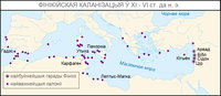 | |
|---|---|---|
| Cyprus | ||
| Greece | ||
| Italy | ||
| Lebanon | ||
| Libya | ||
| Malta |
| |
| Mauritania / Morocco | ||
| Israel | ||
| Portugal | ||
| Spain | ||
| Syria | ||
| Tunisia | ||
| Turkey / others | ||
|  | |||||||||||||||||||||||||||||||||||||||||||||||||||||||||||||||||||||||||
|
| ||||||||||||||||||||||||||||||||||||||||||||||||||||||||||||||||||||||||||
| ||||||||||||||||||||||||||||||||||||||||||||||||||||||||||||||||||||||||||
| ||||||||||||||||||||||||||||||||||||||||||||||||||||||||||||||||||||||||||
| ||||||||||||||||||||||||||||||||||||||||||||||||||||||||||||||||||||||||||
| ||||||||||||||||||||||||||||||||||||||||||||||||||||||||||||||||||||||||||
Coordinates: 35°46′N 5°48′W / 35.767°N 5.800°W