Colonia del Sacramento
| Colonia del Sacramento | |
|---|---|
| Capital city | |
|
| |
 Colonia del Sacramento | |
| Coordinates: 34°28′17″S 57°50′39″W / 34.47139°S 57.84417°WCoordinates: 34°28′17″S 57°50′39″W / 34.47139°S 57.84417°W | |
| Country |
|
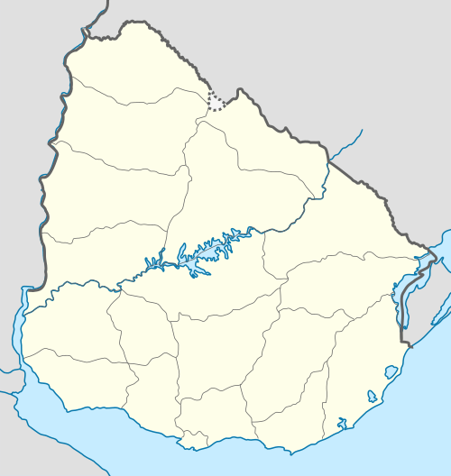
| Department | Colonia |
| Founded | 1680 |
| Founded by | Manuel Lobo |
| Elevation | 27 m (89 ft) |
| Population (2011) | |
| • Total | 26,231 |
| Time zone | UTC -3 |
| Postal code | 70000 |
| Dial plan | +598 452 (+5 digits) |
| Climate | Cfa |
Colonia del Sacramento (Spanish pronunciation: [koˈlonja ðel sakɾaˈmento]; formerly the Portuguese Colónia do Sacramento) is a city in southwestern Uruguay, by the Río de la Plata, facing Buenos Aires, Argentina. It is one of the oldest towns in Uruguay and capital of the Colonia Department. It has a population of around 27,000.
It is renowned for its historic quarter, a UNESCO World Heritage Site.[1] Modern Colonia del Sacramento produces textiles and has a free trade zone, in addition to a polytechnic centre and various government buildings.
History
Founded in 1680 by Portugal as Colónia do Sacramento, the colony was later disputed by the Spanish who settled on the opposite bank of the river at Buenos Aires. The colony was conquered by José de Garro in 1680, but returned to Portugal the next year. It was conquered again by the Spanish in March 1705 after a siege of five months, but given back in the Treaty of Utrecht. Another attack during the Spanish-Portuguese War, 1735-1737, failed.
It kept changing hands from crown to crown due to treaties such as the Treaty of Madrid in 1750 and the Treaty of San Ildefonso in 1777, until it remained with the Spanish. It then transferred to Portuguese control again, being later incorporated into Brazil after 1816, when the entire Banda Oriental (Uruguay) was seized by the government of the United Kingdom of Portugal, Brazil and the Algarves and renamed the Cisplatina province.
On 10 January 1809, before the independence of Uruguay, it was designated as a "Villa" (town) and has since been elevated to the status of "Ciudad" (city).
Since independence, Colonia del Sacramento has expanded to the north and east, but the original Bairro Histórico (historic quarter in Portuguese or Barrio Histórico, current Spanish spelling) retains its irregular, terrain-fitting street plan built by the Portuguese, contrasting with the wider, orthogonal calles in the newer Spanish area.
Timeline of rule
The rule from 1680 to present (with flag of the period) is:
| From | To | Rule | Reason for Handover |
|---|---|---|---|
| 1680 | 1680 | | conquered by José de Garro |
| 1680 | 1681 | | Provisional Treaty of Lisbon |
| 1681 | 1705 | | conquered in the War of Spanish Succession |
| 1705 | 1713 | | Treaty of Utrecht |
| 1714 | 1762 | | First Cevallos expedition |
| 1762 | 1763 | | Treaty of Paris (1763) |
| 1763 | 1777 | | Second Cevallos expedition |
| 1777 | 1811 | | Revolt led by José Gervasio Artigas |
| 1811 | 1817 | | Portuguese conquest |
| 1817 | 1822 | | Brazilian Declaration of Independence |
| 1822 | 1828 | | Cisplatine War |
| 1828 | present | |
Population
In 2011 Colonia del Sacramento had a population of 26,231.[2]
| Year | Population |
|---|---|
| 1908 | 8,021 |
| 1963 | 12,846 |
| 1975 | 17,046 |
| 1985 | 19,102 |
| 1996 | 22,200 |
| 2004 | 21,714 |
| 2011 | 26,231 |
Source: Instituto Nacional de Estadística de Uruguay[3]
Climate
Colonia del Sacramento has a mild humid subtropical climate, described by the Köppen climate classification as Cfa. Summers are warm and winters are cool, with relatively frequent frosts and fog. The precipitation is evenly distributed throughout the year, with an average of 1,039 mm (40.91 in), and the annual average temperature is 17 °C (63 °F).
| Climate data for Colonia del Sacramento , Uruguay | |||||||||||||
|---|---|---|---|---|---|---|---|---|---|---|---|---|---|
| Month | Jan | Feb | Mar | Apr | May | Jun | Jul | Aug | Sep | Oct | Nov | Dec | Year |
| Record high °C (°F) | 39.6 (103.3) |
35.8 (96.4) |
34.9 (94.8) |
31.6 (88.9) |
30.9 (87.6) |
25.8 (78.4) |
30.6 (87.1) |
28.8 (83.8) |
30.6 (87.1) |
32.8 (91) |
36.4 (97.5) |
38.0 (100.4) |
39.6 (103.3) |
| Average high °C (°F) | 27.3 (81.1) |
27.2 (81) |
25.4 (77.7) |
21.7 (71.1) |
18.3 (64.9) |
14.9 (58.8) |
14.6 (58.3) |
16.0 (60.8) |
18.0 (64.4) |
20.9 (69.6) |
23.8 (74.8) |
26.7 (80.1) |
21.2 (70.2) |
| Daily mean °C (°F) | 23.7 (74.7) |
22.9 (73.2) |
21.2 (70.2) |
17.9 (64.2) |
14.8 (58.6) |
11.7 (53.1) |
11.4 (52.5) |
12.2 (54) |
14.1 (57.4) |
16.8 (62.2) |
19.5 (67.1) |
22.3 (72.1) |
17.4 (63.3) |
| Average low °C (°F) | 19.2 (66.6) |
18.8 (65.8) |
17.2 (63) |
14.3 (57.7) |
11.4 (52.5) |
8.7 (47.7) |
8.1 (46.6) |
8.9 (48) |
10.3 (50.5) |
12.8 (55) |
15.0 (59) |
17.6 (63.7) |
13.5 (56.3) |
| Record low °C (°F) | 10.1 (50.2) |
10.3 (50.5) |
8.1 (46.6) |
5.1 (41.2) |
0.2 (32.4) |
0.0 (32) |
−0.7 (30.7) |
0.4 (32.7) |
1.5 (34.7) |
4.7 (40.5) |
4.1 (39.4) |
8.8 (47.8) |
−0.7 (30.7) |
| Average precipitation mm (inches) | 92 (3.62) |
116 (4.57) |
125 (4.92) |
91 (3.58) |
78 (3.07) |
66 (2.6) |
69 (2.72) |
76 (2.99) |
80 (3.15) |
113 (4.45) |
108 (4.25) |
87 (3.43) |
1,099 (43.27) |
| Average precipitation days (≥ 1.0 mm) | 6 | 6 | 6 | 6 | 5 | 5 | 5 | 5 | 6 | 7 | 7 | 6 | 70 |
| Average relative humidity (%) | 70 | 73 | 74 | 77 | 79 | 81 | 79 | 78 | 75 | 74 | 72 | 69 | 75 |
| Mean monthly sunshine hours | 285.6 | 223.1 | 228.5 | 182.9 | 166.1 | 137.0 | 142.6 | 168.1 | 194.6 | 232.2 | 240.9 | 270.0 | 2,471.6 |
| Source: Dirección Nacional de Meteorología[4] | |||||||||||||
Urban fabric
The city was developed on a peninsula that protrudes into the Río de la Plata. The 16 hectare "Barrio Histórico", or Portuguese Old City, was enclosed by a fortification wall across the peninsula in the site of present-day Calle Ituzaingó. Most of the fortification wall was removed in 1777 and the remaining parts in 1859. The Portuguese part of the city has an irregular street network.
Outside the wall, the historical part of the city was planned in Spanish colonial style and in the characteristic checkerboard layout.
Points of interest
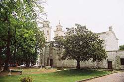
The Barrio Histórico (historic quarter) section of Colonia del Sacramento is designated a World Heritage Site by UNESCO. It is a popular tourist attraction for visitors from Buenos Aires, and there is frequent ferry service across the Río de la Plata between the two cities, with fast ferries completing the journey in just 50 minutes. The historical section of Colonia, which has some cobblestone streets built by the Portuguese in the 17th century, is within walking distance of the ferry terminal. Among the notable tourist attractions around the tree-lined Plaza Mayor (main square) are:
| Historic Quarter of the City of Colonia del Sacramento | |
|---|---|
| Name as inscribed on the World Heritage List | |
| Type | Cultural |
| Criteria | iv |
| Reference | 747 |
| UNESCO region | Latin America and the Caribbean |
| Inscription history | |
| Inscription | 1995 (19th Session) |
- Portón de Campo – the City Gate and wooden drawbridge
- Lighthouse and convent ruins of the 17th century Convent of San Francisco
- Basílica del Santísimo Sacramento – the Basilica of the Holy Sacrament, built of stone by the Portuguese in 1808
- Portuguese Museum – constructed in the 18th century, it exhibits Portuguese furnishings, jewelry, uniforms and old maps of Portuguese naval expeditions
- Casa de Nacarello – an 18th-century Portuguese house
- Municipal Museum – rebuilt by the Spanish in 1835 as the Casa del Almirante Brown, it exhibits artifacts and documents of the city's different periods and cultures
- Viceroy's House – the Casa del Virrey, reconstructed from the original ruins
- Plaza de toros Real de San Carlos, a Bullring included in an old tourist complex now abandoned.
Gallery
- Views of the Barrio Histórico
 Map of the Old City in ceramic tiles
 View of the historic district from the top of the lighthouse
 Portón de Campo, the City Gate
 Another view of the City Gate
 Lighthouse at Colonia del Sacramento
 Calle San Pedro, a typical street in the historic district
 The 1866 Wharf of Colonia
 The water front
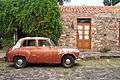 Old car parked on Calle Real in the historic district
 Night at the historic quarter district - "Misiones de los Tapes" Street
 The Buquebus seen from the Paseo San Gabriel
 Wall art in Colonia del Sacramento
 Remains of Portuguese Azulejo
Transportation
Colonia del Sacramento is served by three ferry boat lines from Buenos Aires, Argentina: "Buquebus", "Seacat Colonia" and "Colonia Express".
Two principal highways end in Colonia: Route 1 connects Colonia to Montevideo and points east; Route 21 connects to points north, including the Aarón de Anchorena National Park, 30 kilometres (19 mi) distant, and Fray Bentos. There is also a local airport for small planes. There is a project in process to lengthen the runway and begin commercial flights to Buenos Aires (this was done in the past) and other cities within Uruguay.
The city is served by Laguna de los Patos International Airport located 17 km from Colonia along Route 1.
Consular representation
Argentina and Portugal both maintain a consulate in Colonia del Sacramento.
Twin town/sister city
See also
Bibliography
- Assunção, Fernando O.; Cravotto, Antonio (1996). Colonia del Sacramento, patrimonio mundial. Montevideo: UNESCO. (with prologue by Federico Mayor Zaragoza and introduction by Marta Canessa de Sanguinetti) (Spanish)
References
- ↑ "21 World Heritage Sites you have probably never heard of". The Daily Telegraph. London.
- ↑ "Censos 2011 Cuadros Colonia". INE. 2012. Retrieved 25 August 2012.
- ↑ "Statistics of urban localities (1963–2004)" (PDF). INE. 2012. Retrieved 3 September 2012.
- ↑ "Estadísticas climatológicas" (in Spanish). Dirección Nacional de Meteorología. Retrieved 10 October 2012.
- ↑ (Portuguese) Cidades-irmãs de Pelotas terão espaço na Fenadoce, Prefeitura Municipal de Pelotas - accessed on June 4, 2007.
External links
| Wikimedia Commons has media related to Colonia del Sacramento. |
| Wikivoyage has a travel guide for Colonia. |
- Article on Colonia del Sacramento, Official Portal of the Uruguayan Government
- 360° Virtual Tours of Colonia del Sacramento - Uruguay360.com.uy
- Tourist information about Colonia del Sacramento
- Tourist guide about Colonia del Sacramento – photos, hosting and attractions of Colonia del Sacramento attractions
- Colonia del Sacramento Website
- INE map of Colonia del Sacramento
| Resorts and Landforms |
|
|---|---|
| |
Capital: Colonia del Sacramento | ||
| Towns and villages |  | |
| Sights | ||
|  | |||||||||||||||||||||||||||||||||||||||||||||||||||||||||||||||||||||||||
|
| ||||||||||||||||||||||||||||||||||||||||||||||||||||||||||||||||||||||||||
| ||||||||||||||||||||||||||||||||||||||||||||||||||||||||||||||||||||||||||
| ||||||||||||||||||||||||||||||||||||||||||||||||||||||||||||||||||||||||||
| ||||||||||||||||||||||||||||||||||||||||||||||||||||||||||||||||||||||||||
| ||||||||||||||||||||||||||||||||||||||||||||||||||||||||||||||||||||||||||
| ||