Spanish Florida
| Government of Florida La Florida | |||||
| Territory of New Spain | |||||
| |||||
|
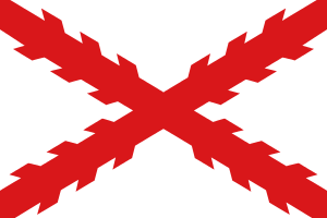
Royal standard of Castile (1503) | |||||
| Motto Plus Ultra (Further Beyond) | |||||
| Anthem Marcha Real (Royal March) | |||||
| Capital | St. Augustine | ||||
| Government | Monarchy | ||||
| History | |||||
| • | Spanish exploration and settlement | 1513–1698 | |||
| • | Transferred to Britain | 1763 | |||
| • | Returned to Spain | 1783 | |||
| • | Pinckney's Treaty | 1795 | |||
| • | Occupation of Pensacola | 1814 | |||
| • | Adams-Onís Treaty signed | 1819 | |||
| • | Treaty ratified. Joined U.S. | 1821 | |||
| Today part of | | ||||
Spanish Florida refers to the Spanish territory of La Florida, which was the first major European land claim and attempted settlement in North America during the European Age of Discovery. La Florida formed part of the Captaincy General of Cuba, the Viceroyalty of New Spain, and the Spanish Empire during Spanish colonization of the Americas. While it had no clearly defined boundaries, the territory was much larger than the present-day state of Florida, extending over much of what is now the southeastern United States, including all of present-day Florida plus portions of Georgia, Alabama, Mississippi, South Carolina, and southeastern Louisiana. Spain's claim to this vast area was based on several wide-ranging expeditions mounted during the 16th century. However, Spain never exercised real control over La Florida much beyond several settlements and forts which were predominantly located in present-day Florida.
Spanish Florida was established in 1513, when Juan Ponce de León claimed peninsular Florida for Spain during the first official European expedition to North America. This claim was enlarged as several explorers (most notably Pánfilo Narváez and Hernando de Soto) landed near Tampa Bay in the mid-1500s and wandered as far north as the Appalachian Mountains and as far west as Texas in largely unsuccessful searches for gold and other riches. The presidio of St. Augustine was founded on Florida's Atlantic coast in 1565; a series of missions were established across the Florida panhandle, Georgia, and South Carolina during the 1600s; and Pensacola was founded on the western Florida panhandle in 1698, strengthening Spanish claims to that section of the territory.
Spanish control of the Florida peninsula was helped made possible by the collapse of native cultures during the 17th century. Several Native American groups (including the Timucua, Calusa, Tequesta, Apalachee. Tocobaga, and the Ais people) had been long-established residents of Florida, and most resisted Spanish incursions onto their land. However, conflict with Spanish expeditions, raids by the English and their native allies, and (especially) diseases brought from Europe resulted in a drastic decline in the population of all of the indigenous peoples of Florida, and the large swaths of peninsula were largely uninhabited by the early 1700s. During the mid-1700s, small bands of Creek and other Native American refugees began moving south into Spanish Florida after having been forced off their lands by English settlements and raids. They were later joined by African-Americans fleeing slavery in nearby colonies. These newcomers - plus perhaps a few surviving descendents of indigenous Florida peoples - eventually coalesced into a new Seminole culture.
The wide expanses of Spanish Florida gradually shrunk beginning in the 1600s. The Spanish mission system was gradually abandoned due to native depopulation, and between disease, poor management, and ill-timed hurricanes, several Spanish attempts to establish additional settlements in La Florida ended in failure. With no gold or silver in the region, Spain regarded Florida (and particularly the heavily fortified town of St. Augustine) primarily as a buffer between its more prosperous colonies to the south and west and several newly established rival European colonies to the north. The establishment of the Province of Carolina by the English in 1639, New Orleans by the French in 1718, and of the Province of Georgia by Great Britain in 1732 limited the boundaries of Florida over Spanish objections. The War of Jenkins' Ear (1739 - 1748) included a British attack on St. Augustine and a Spanish invasion of Georgia, both of which were repulsed. At the conclusion of the war, the northern boundary of Spanish Florida was set near the current northern border of modern day Florida.
Great Britain temporarily gained control of Florida beginning in 1763 as a result of the Anglo-Spanish War, but while Britain occupied the territory, it did not develop it further. Sparsely populated British Florida stayed loyal to Crown during the American Revolutionary War, and by the terms of the Treaty of Paris which ended the war, the territory was returned to Spain in 1783. After a brief diplomatic border dispute with the fledgling United States, the countries set a territorial border and allowed Americans free navigation of the Mississippi River by the terms of Pinckney's Treaty in 1795.
France sold Louisiana to the United States in 1803. The U.S. claimed that the transaction included West Florida, while Spain insisted that the area was not part of Louisiana and was still Spanish territory. In 1810, the United States intervened in a local uprising in West Florida, and by 1812, the Mobile District was absorbed into the U.S. territory of Mississippi, reducing the borders of Spanish Florida to that of modern Florida.
In the early 1800s, tensions rose along the unguarded border between Spanish Florida and the state of Georgia as settlers skirmished with Seminoles over land and American slave-hunters raided Black Seminole villages in Florida. These tensions were exacerbated when the Seminoles aided Great Britain against the United States during the War of 1812 and led to American military incursions into northern Florida beginning in late 1814 during what became known as the First Seminole War. As with earlier American incursions into Florida, Spain protested this invasion but could not defend its territory, and instead opened diplomatic negotiations seeking a peaceful transfer of land. By the terms of the Adams-Onis Treaty of 1819, Spanish Florida ceased to exist in 1821, when control of the territory was officially transferred to the United States.
Discovery and early exploration

Cantino planisphere
Anonymous Portuguese sailors were likely the first Europeans to map the southeastern portion of the future United States. As documented in the Cantino planisphere of 1502, Portugal explored the Atlantic coast and the eastern Gulf of Mexico some time in the decade following Christopher Columbus's first voyage. (Columbus never sighted North America in any of his expeditions.) However, they kept their discoveries secret, and they did not attempt to establish settlements or explore very far inland.[1]
_1.083_JUAN_PONCE_DE_LE%C3%93N.jpg)
Juan Ponce de León
In 1512 Juan Ponce de León, governor of Puerto Rico, received royal permission to search for land north of Cuba. On March 3, 1513, his expedition departed from Punta Aguada, Puerto Rico, sailing north in three ships.[2] In late March, he spotted a small island (almost certainly one of the Bahamas) but did not land. On April 2, Ponce de León spotted the east coast of the Florida peninsula and went ashore the next day at an exact location that has been lost to time.[3] Assuming that he had found a large island, he claimed the land for Spain and named it La Florida, because it was the season of Pascua Florida ("Flowery Easter") and because much of the vegetation was in bloom.[4] After briefly exploring the area around their landing site, the expedition returned to their ships and sailed south to map the coast, encountering the Gulf Stream along the way. The expedition followed Florida's coastline all the way around the Florida Keys and north to map a portion of the Southwest Florida coast before returning to Puerto Rico.
Popular legend has it that Ponce de León was searching for the Fountain of Youth when he discovered Florida. However, the first mention of Ponce de León searching for water to cure his aging came more than twenty years after his voyage of discovery, and the first that placed the Fountain of Youth in Florida was thirty years after that. It is much more likely that Ponce de León, like other Spanish conquistadors in the Americas, was looking for gold, land to colonize and rule for Spain, and Indians to convert to Christianity or enslave.[5]
Ponce de León probably was not the first Spaniard to reach Florida,[6]:107 although he was the first to do so with permission from the Spanish crown. Evidence suggests that Spanish raiders from the Caribbean had conducted small secret expeditions to Florida to capture Indian slaves.[6]:107 The Native Americans encountered by Ponce de León were hostile at first contact, and he met an Indian in Florida who knew some Spanish words.[6]:106–110
Other Spanish voyages to Florida quickly followed Ponce de León's return. Sometime in the period from 1514 to 1516, Pedro de Salazar enslaved as many as 500 Indians along the Atlantic coast of the present-day southeastern United States. Diego Miruelo visited what was probably Tampa Bay in 1516, Francisco Hernández de Cordova reached southwest Florida in 1517, and Alonso Álvarez de Pineda sailed and mapped all of the Gulf of Mexico coast in 1519.
First colonization attempts
In 1521, Ponce de León sailed from Cuba with 200 men in two ships to establish a colony on the southwest coast of the Florida peninsula, probably near Charlotte Harbor. However, attacks by the native Calusa drove the colonists away in July 1521. After the skirmish, Ponce de Leon was wounded as he had an arrow sticking out of his thigh. However, that was not the only injury he had during the battle.[7] Ponce de Leon died of his injuries upon the expedition's return to Havana.[8]
In 1521 Pedro de Quejo and Francisco Gordillo enslaved 60 Indians at Winyah Bay, South Carolina. Quejo, with the backing of Lucas Vázquez de Ayllón, returned to the region in 1525, stopping at several locations between Amelia Island and the Chesapeake Bay. In 1526 de Ayllón led an expedition of some 600 people to the South Carolina coast. After scouting possible locations as far south as Ponce de León Inlet in Florida, the settlement of San Miguel de Gualdape was established in the vicinity of Sapelo Sound, Georgia. Disease, hunger, cold and Indian attacks led to San Miguel being abandoned after only two months. About 150 survivors returned to Spanish settlements.[6]:111–115 Dominican friars Fr. Antonio de Montesinos and Fr. Anthony de Cervantes were among the colonists. Given that at the time priests were obliged to say mass each day, it is historically safe to assert that Catholic Mass was celebrated in what is today the United States for the first time, by these Dominicans, even though the specific date and location remains unclear.[9]
Narváez expedition
In 1527 Pánfilo de Narváez left Spain with five ships and about 600 people on a mission to explore and to settle the coast of the Gulf of Mexico between the existing Spanish settlements in Mexico and Florida. After storms and delays, the expedition landed near Tampa Bay on April 12, 1528, already short on supplies, with about 400 people. Confused as to the location of Tampa Bay (Milanich notes that a navigation guide used by Spanish pilots at the time placed Tampa Bay some 90 miles too far north), Narváez sent his ships in search of it while most of the expedition marched northward, supposedly to meet the ships at the bay.
Intending to find Tampa Bay, Narváez marched close to the coast, through what turned out to be largely uninhabited territory. The expedition was forced to subsist on the rations they had brought with them, until they reached the Withlacoochee River, where they finally encountered Indians. Seizing hostages, the expedition reached the Indians' village, where they found corn. Further north they were met by a chief who led them to his village on the far side of the Suwannee River. The chief, Dulchanchellin, tried to enlist the Spanish as allies against his enemies, the Apalachee.
Seizing Indians as guides, the Spaniards traveled northwest towards the Apalachee territory. Milanich suggests that the guides led the Spanish on a circuitous route through the roughest country they could find. In any case, the expedition did not find the larger Apalachee towns. By the time the expedition reached Aute, a town near the Gulf Coast, it had been under attack by Indian archers for many days. Plagued by illness, short rations, and hostile Indians, Narváez decided to sail to Mexico rather than attempt an overland march. Two hundred and forty two men set sail on five crude rafts. All the rafts were wrecked on the Texas coast. After eight years, four survivors, including Álvar Núñez Cabeza de Vaca, reached New Spain (Mexico). A fifth, Juan Ortiz, escaped from captivity with the Indians after 12 years.
De Soto expedition
Hernando de Soto had been one of Francisco Pizarro's chief lieutenants in the Spanish conquest of the Inca Empire, and had returned to Spain a very wealthy man. He was appointed Adelantado of Florida and governor of Cuba, and assembled a large expedition to 'conquer' Florida. On May 30, 1539, de Soto and his companions landed in Tampa Bay, where they found Juan Ortiz, who had been captured by the local Indians a decade earlier when he was sent ashore from a ship searching for Narváez. Ortiz passed on the Indian reports of riches, including gold, to be found in Apalachee, and de Soto set off with 550 soldiers, 200 horses, and a few priests and friars. De Soto's expedition lived off the land as it marched. De Soto followed a route further inland than that of Narváez's expedition, but the Indians remembered the earlier disruptions caused by the Spanish, and were wary when not outright hostile. De Soto seized Indians to serve as guides and porters.
The expedition reached Apalachee in October, and settled into the chief Apalachee town of Anhaica for the winter, where they found large quantities of stored food, but little gold or other riches. In the spring de Soto set out to the northeast, crossing what is now Georgia and South Carolina into North Carolina, then turned westward, crossed the Great Smoky Mountains into Tennessee, then marched south into Georgia. Turning westward again, the expedition crossed Alabama. They lost all of their baggage in a fight with Indians near Choctaw Bluff on the Alabama River, and spent the winter in Mississippi. In May 1541 the expedition crossed the Mississippi River and wandered through present-day Arkansas, Missouri and possibly Kansas before spending the winter in Oklahoma. In 1542 the expedition headed back to the Mississippi River, where de Soto died. Three hundred and ten survivors returned from the expedition in 1543.
Ochuse and Santa Elena
Although the Spanish had lost hope of finding gold and other riches in Florida, it was seen as vital to the defense of their colonies and territories in Mexico and the Caribbean. In 1559 Tristán de Luna y Arellano left Mexico with 500 soldiers and 1,000 civilians on a mission to establish colonies at Ochuse (Pensacola Bay) and Santa Elena (Port Royal Sound). The plan was to land everybody at Ochuse, with most of the colonists marching overland to Santa Elena. A tropical storm struck five days after the fleet's arrival at the Bay of Ochuse, sinking ten of the thirteen ships along with the supplies that had not yet been unloaded. Expeditions into the interior failed to find adequate supplies of food. Most of the colony moved inland to Nanicapana, renamed Santa Cruz, where some food had been found, but it could not support the colony and the Spanish returned to Pensacola Bay. In response to a royal order to immediately occupy Santa Elena, Luna sent three small ships, but they were damaged in a storm and returned to Mexico. Angel de Villafañe replaced the discredited Luna in 1561, with orders to withdraw most of the colonists from Ochuse and occupy Santa Elena. Villafañe led 75 men to Santa Elena, but a tropical storm damaged his ships before they could land, forcing the expedition to return to Mexico.
Settlement and fortification
The establishment of permanent settlements and fortifications in Florida by Spain was in response to the challenge posed by French Florida: French captain Jean Ribault led an expedition to Florida, and established Charlesfort on what is now Parris Island, South Carolina in 1562. However, the French Wars of Religion prevented Ribault from returning to resupply the fort, and the men abandoned it.[10]:196–199 Two years later, René Goulaine de Laudonnière, Ribault's lieutenant on the previous voyage, set out to found a haven for Protestant Huguenot colonists in Florida. He founded Fort Caroline at what is now Jacksonville in July 1564. Once again, however, a resupplying mission by Ribault failed to arrive, threatening the colony. Some mutineers fled Fort Caroline to engage in piracy against Spanish colonies, causing alarm among the Spanish government. Laudonnière nearly abandoned the colony in 1565, but Jean Ribault finally arrived with supplies and new settlers in August.[10]:199–200
At the same time, in response to French activities, King Philip II of Spain appointed Pedro Menéndez de Avilés Adelantado of Florida, with a commission to drive non-Spanish adventurers from all of the land from Newfoundland to St. Joseph Bay (on the north coast of the Gulf of Mexico).[11] Menéndez de Avilés reached Florida at the same time as Ribault in 1565, and established a base at San Agustín (St. Augustine in English), the oldest continuously inhabited European-established settlement in what is now the continental United States.[12] Menéndez de Avilés quickly set out to attack Fort Caroline, traveling overland from St. Augustine. At the same time, Ribault sailed from Fort Caroline, intending to attack St. Augustine from the sea. The French fleet, however, was pushed out to sea and decimated by a squall. Meanwhile, the Spanish overwhelmed the lightly defended Fort Caroline, sparing only the women and children.[10]:200–202[13] Some 25 men were able to escape. When the Spanish returned south and found the French shipwreck survivors, Menéndez de Avilés ordered all of the Huguenots executed.[13]:94 The location became known as Matanzas.[10]:202
Following the expulsion of the French, the Spanish renamed Fort Caroline Fort San Mateo (Saint Matthew).[13] Two years later, Dominique de Gourgues recaptured the fort from the Spanish and slaughtered all of the Spanish defenders.[14]
Missions and conflicts
In 1549 Father Luis de Cancer and three other Dominicans attempted the first solely missionary expedition in la Florida. Following decades of native contact with Spanish laymen who had ignored a 1537 Papal Bull which condemned slavery in no uncertain terms, the religious order's effort was abandoned after only 6 weeks with de Cancer's brutal martyrdom by Tocobaga natives. His death sent shock waves through the Dominican missionary community in New Spain for many years.
In 1566, the Spanish established the colony of Santa Elena on what is now Parris Island, South Carolina.[13]:95 Juan Pardo led two expeditions (1566-7 and 1567-8) from Santa Elena as far as eastern Tennessee, establishing six temporary forts in interior. The Spanish abandoned Santa Elena and the surrounding area in 1587.[15]
In 1586, English sea captain Francis Drake plundered and burned St. Augustine, including a fortification that was under construction, while returning from raiding Santo Domingo and Cartagena in the Caribbean.[16]:429[17] His raids exposed Spain's inability to properly defend her settlements.[17]
The Jesuits had begun establishing missions to the Native Americans in Florida in 1567, but withdrew in 1572 after hostile encounters with the natives.[16]:311 In 1573 Franciscans assumed responsibility for missions to the Native Americans, eventually operating dozens of missions to the Guale, Timucua and Apalachee tribes.[18] The missions were not without conflict and the Guale first rebelled on October 4, 1597 in what is now present-day coastal Georgia.[19]:954
The extension of the mission system also provided a military strategic advantage from British troops arriving from the North.[16]:311 During the hundred-plus year span of missionary expansion, disease from the Europeans had a significant impact on the natives, along with the rising power of the French and British.[20] During the Queen Anne's War, the British dismantled much of the missions.[20] By 1706, the missionaries retracted from their mission outposts and returned to St. Augustine.
Period of friendship

Spanish Governor Pedro de lbarra worked at establishing peace with the native cultures to the South of St. Augustine. An account is recorded of his meeting with great Indian caciques (chiefs).[21] Ybarra (Ibarra) in 1605 sent Alvaro Mexia, a cartographer, on a mission further South to meet and develop diplomatic ties with the Ais Indian nation, and to make a map of the region. His mission was successful.
In February 1647, the Apalachee revolted.[19]:27 The revolt changed the relationship between Spanish authorities and the Apalachee. Following the revolt, Apalachee men were forced to work on public projects in St. Augustine or on Spanish-owned ranches.[22] In 1656, the Timucua rebelled, disrupting the Spanish missions in Florida. This also affected the ranches and food supplies for St. Augustine.
Throughout the 17th century, English and Scottish colonists from the Carolina and Virginia colonies gradually pushed the frontier of Spanish territory south. In the early 18th century, French settlements along the Mississippi River and Gulf Coast encroached on the western borders of the Spanish claim.
Starting in 1680, English and Scottish soldiers from Carolina and their Native American allies repeatedly attacked Spanish mission villages and St. Augustine, burning missions and killing and enslaving Indians. In 1702, James Moore led an army of colonists and a Native American force of Yamasee, Tallapoosa, Alabama, and other Creek warriors under the Yamasee chief Arratommakaw. The army attacked and razed the town of St. Augustine, but could not gain control of the fort. Moore in 1704 made a series of raids into the Apalachee Province of Florida, looting and destroying most of the remaining Spanish missions and killing or enslaving most of the Indian population. By 1707 the few surviving Indians had fled to Spanish St. Augustine and Pensacola, or French Mobile. Some of the Native Americans captured by Moore's army were resettled along the Savannah and the Ocmulgee rivers in Georgia.
In 1696 the Spanish had founded Pensacola near the former site of Ochuse. In 1719, the French captured the Spanish settlement at Pensacola.
During the 18th century, the Native American peoples who would become the Seminoles began their migration to Florida, which had been largely depopulated by Carolinian and Yamasee slave raids. British Carolina's power was damaged and the colony nearly destroyed during the Yamasee War of 1715–1717, after which the Native American slave trade was radically reformed.
Possession by Britain
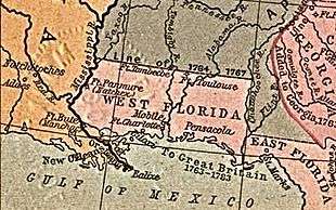
In 1763, Spain traded Florida to Great Britain in exchange for control of Havana, Cuba, which had been captured by the British during the Seven Years' War. As Britain had defeated France in the war, it took over all of French Louisiana east of the Mississippi River, except for New Orleans. Finding this new territory too vast to govern as a single unit, Britain divided the southernmost areas into two territories separated by the Apalachicola River: East Florida (the peninsula) and West Florida (the panhandle).
The British soon began aggressive recruiting to attract colonists to the area, offering free land and backing for export-oriented businesses. In 1764, the British moved the northern boundary of West Florida to a line extending from the mouth of the Yazoo River east to the Chattahoochee River (32° 22′ north latitude), consisting of approximately the lower third of the present states of Mississippi and Alabama, including the valuable Natchez District.
During this time, Creek Indians began to migrate into Florida, leading to the formation of the Seminole tribe. The aboriginal peoples of Florida had been devastated by war and disease, and it is thought most of the survivors accompanied the Spanish settlers when they left for other colonies (mostly French) in 1763. This left wide expanses of territory open to the Lower Creeks, who had been in conflict with the Upper Creeks of Alabama for years. The Seminole originally occupied the wooded areas of northern Florida. Under pressure from colonists and the United States Army in the Seminole Wars, they migrated into central and southern Florida, to the Everglades. Many of their descendants live in this area today as one of the two federally recognized Seminole tribes in the state.
Britain retained control over East Florida during the American Revolutionary War, but the Spanish, by that time allied with the French who were at war with Britain, recaptured most of West Florida. At the end of the war, the Peace of Paris (1783) between the Kingdoms of Great Britain and Spain ceded all of East and West Florida to Spanish control, but without specifying the boundaries.
Second Spanish period

Spain gained possession of West Florida and regained East Florida from Britain in the Peace of Paris of 1783, and continued the British practice of governing the Floridas as separate territories: West Florida and East Florida. When Spain acquired West Florida in 1783, the eastern British boundary was the Apalachicola River, but Spain in 1785 moved it eastward to the Suwannee River.[23][24] The purpose was to transfer San Marcos and the district of Apalachee from East Florida to West Florida.[25][26]
After American independence, the lack of specified boundaries led to a border dispute with the newly formed United States, known as the West Florida Controversy. The two 1783 treaties that ended the American Revolutionary War had differences in boundaries. The Treaty of Paris between Britain and the United States specified the boundary between West Florida and the newly independent U.S. at 31°.[27] However, in the companion Peace of Paris between Britain and Spain, West Florida was ceded to Spain without its boundaries being specified. The Spanish government assumed that the boundary was the same as in the 1763 agreement by which they had first given their territory in Florida to Britain, claiming that the northern boundary of West Florida was at the 32° 22′ boundary established by Britain in 1764 after the Seven Years' War. The British line at 32° 22′ was close to Spain's old claim of 32° 30′, which dated to the 1670 Treaty of Madrid.[28] The now independent United States insisted that the boundary was at 31°, as specified in its Treaty of Paris with Britain.
After American independence, Spain claimed far more land than the old British West Florida, including the east side of the Mississippi River north to the Ohio and Tennessee rivers.[29] This expanded claim was based on Spain's successful military operations against the British in the region during the war. Spain occupied or built several forts north of the old British West Florida border, including Fort Confederación, Fort Nogales (at present-day Vicksburg), and Fort San Fernando (at present-day Memphis).[30][31] Spain tried to settle the dispute quickly, but the U.S. delayed, knowing that time was on its side.[29] By Pinckney's Treaty of 1795 with the United States, Spain recognized the 31st parallel as the border, ending the first West Florida Controversy. Andrew Ellicott surveyed this parallel in 1797, as the border between the United States and Spanish territories.
In 1798, Ellicott reported to the government that four American generals were receiving pensions from Spain, including General James Wilkinson.
In the early 19th century, Spain offered generous land packages in Florida as a means of attracting settlers, and attracted substantial numbers, both from Spain and from the United States. After settler attacks on Indian towns, Indians based in Florida began raiding Georgian settlements, purportedly at the behest of the Spanish. The United States Army led increasingly frequent incursions into Spanish territory, including an 1810–1812 filibuster campaign by George Mathews (with participation by the U.S. Navy) that became known as the Patriot War of East Florida, and an 1817–1818 campaign against the Seminole by Andrew Jackson that became known as the First Seminole War. Following the war, the United States effectively controlled East Florida. By this time, the United States was also concerned about the armed blacks in Spanish Florida, who became known as the Black Seminoles. Slaveholders wanted to reclaim fugitive slaves, and slave raiders entered the territory.
The Adams-Onís Treaty was signed between the United States and Spain on February 22, 1819, and took effect on July 17, 1821. According to the terms of the treaty, the United States acquired Florida, and, in exchange, renounced all its claims to Texas. Hundreds of Black Seminoles escaped from Cape Florida to the Bahamas in the early 1820s, to avoid US slave raiders.
See also
- List of colonial governors of Florida
- European colonization of the Americas
- History of Florida
- Spanish Louisiana
- Spanish West Florida
- West Florida
- Florida Territory
References
- Specific
- ↑ "Exhibit maps Florida history". StAugustine.com. Retrieved 5 April 2015.
- ↑ PROCLAMATION presented by Dennis O. Freytes, MPA, MHR, BBA, Chair/Facilitator, 500TH Florida Discovery Council Round Table, American Veteran, Community Servant, VP NAUS SE Region; Chair Hispanic Achievers Grant Council
- ↑ "Court tries, fails to determine Ponce de Leon's landing site". palmbeachpost.com. Retrieved 5 April 2015.
- ↑ Jonathan D. Steigman (25 September 2005). La Florida Del Inca and the Struggle for Social Equality in Colonial Spanish America. University of Alabama Press. p. 33. ISBN 978-0-8173-5257-8.
- ↑ "The Myth of Ponce de León and the Fountain of Youth". History.com. Retrieved 5 April 2015.
- 1 2 3 4 Milanich, Jerald T. (1995). Florida Indians and the Invasion from Europe. Gainesville, Florida, U.S.: University Press of Florida. ISBN 0-8130-1360-7.
- ↑ "Juan Ponce de Leon Biography". Biography.com website. A&E Television Networks. Retrieved March 3, 2016.
- ↑ "Juan Ponce de Leon – biography – Spanish explorer". Encyclopedia Britannica. Retrieved 5 April 2015.
- ↑ "CATHOLIC ENCYCLOPEDIA: Antonio Montesino". newadvent.org. Retrieved 5 April 2015.
- 1 2 3 4 Sauer, Carl Ortwin (1975). Sixteenth Century North America: The Land and the People As Seen by Europeans. University of California Press. ISBN 0-520-02777-9. Retrieved July 27, 2012.
- ↑ Bushnell:2–3. In 1573 Menéndez de Avilés' territory was extended to the Pánuco River, in New Spain.
- ↑ National Historic Landmarks Program – St. Augustine Town Plan Historic District
- 1 2 3 4 Marley, David (2008). Wars of the Americas: A Chronology of Armed Conflict in the Western Hemisphere (2 Volumes). ABC-CLIO. ISBN 978-1-59884-100-8.
- ↑ Brevard, Caroline Mays (1904). A History of Florida. Harvard University Press. p. 97. Retrieved 8 July 2012.
- ↑ Map showing Spanish Missions in the 1500s
- 1 2 3 M. McAlister, Lyle Spain and Portugal in the New World, 1492–1700. University of Minnesota Press, 1984.
- 1 2 A. Burkholder, Mark; L. Johnson, Lyman Colonial Latin America. Oxford University Press, 1990. p. 145.
- ↑ Middleton, Richard; Lombard, Anne Colonial America: A History to 1763. Wiley-Blackwell 4th Edition, 2007. Chap 15, sec 1.
- 1 2 Spencer C. Tucker; James R. Arnold; Roberta Wiener (30 September 2011). The Encyclopedia of North American Indian Wars, 1607–1890: A Political, Social, and Military History. ABC-CLIO. ISBN 978-1-85109-697-8. Retrieved 13 April 2013.
- 1 2 M. A. Young, Gloria The Expedition of Hernando De Soto West of the Mississippi, 1541–1543. University of Arkansas Press, 1999. p. 24.
- ↑ Rouse, Irving. Survey of Indian River Archaeology. Yale University Publications in Anthropology 45. ISBN 978-0-404-15668-8.
- ↑ McEwan, Bonnie. "San Luis de Talimali (or Mission San Luis)". Florida Humanities Council. Retrieved April 13, 2013.
- ↑ Wright, J. Leitch (1972). "Research Opportunities in the Spanish Borderlands: West Florida, 1781–1821". Latin American Research Review. Latin American Studies Association. 7 (2): 24–34. JSTOR 2502623.
- ↑ Weber, David J. (1992). The Spanish Frontier in North America. New Haven, Connecticut, USA: Yale University Press. p. 275. ISBN 978-0-300-05917-5.
Spain never drew a clear line to separate the two Floridas, but West Florida extended easterly to include Apalachee Bay, which Spain shifted from the jurisdiction of St. Augustine to more accessible Pensacola.
- ↑ "The Evolution of a State, Map of Florida Counties – 1820". 10th Circuit Court of Florida. Retrieved 2016-01-26.
Under Spanish rule, Florida was divided by the natural separation of the Suwanee River into West Florida and East Florida.
- ↑ Klein, Hank. "History Mystery: Was Destin Once in Walton County?". The Destin Log. Retrieved 2016-01-26.
On July 21, 1821 all of what had been West Florida was named Escambia County, after the Escambia River. It stretched from the Perdido River to the Suwanee River with its county seat at Pensacola.
- ↑ Article 2, Treaty of Paris (1783).
- ↑ Meyers, Christopher C. (April 2008). The empire state of the South: Georgia history in documents and essays. Mercer University Press. pp. 14–15. ISBN 978-0-88146-111-4. Retrieved 21 March 2011.
- 1 2 Weber, David J. (1992). The Spanish frontier in North America. New Haven, Connecticut, USA: Yale University Press. pp. 277–279. ISBN 978-0-300-05917-5. Retrieved 21 March 2011.
- ↑ Fort Tombécbe, Alabama Forts
- ↑ "Fort San Fernando De Las Barrancas", The Tennessee Encyclopedia of History and Culture
- General
| Library resources about Spanish Florida |
- Bushnell, Amy Turner. (1981). "Chapter 1: The Florida Provinces and Their Treasury." The King's Coffer: Proprietors of the Spanish Florida Treasury 1565–1702. University of Florida Press. Reprinted in David Hurst Thomas. (1991). Spanish Borderlands Sourcebooks 23: The missions of Spanish Florida. Garland Publishing.
- Milanich, Jerald T. (1995) Florida Indians and the Invasion from Europe. University Press of Florida. ISBN 0-8130-1360-7
- Tebeau, Charlton. (1980) A History of Florida. Rev. Ed. University of Miami Press. ISBN 0-87024-303-9
- Burkholder, Mark A. ; Johnson, Lyman L. Colonial Latin America. Oxford University Press ISBN 0-19-504542-4
- McAlister, Lyle M. Spain and Portugal in the New World, 1492–1700. University of Minnesota Press. ISBN 0-8166-1216-1
- Young, Gloria A. The Expedition of Hernando De Soto West of the Mississippi, 1541–1543. University of Arkansas Press. ISBN 978-1-55728-580-5
- Brevard, Caroline Mays. A History of Florida. Harvard University Press.
- Marley, David. Wars of the Americas: A Chronology of Armed Conflict in the Western Hemisphere (2 Volumes). ABC-CLIO.
- Clark, Larry. (2010) "Spanish Attempts to Colonize Southeast North America, 1513-1587." McFarland & Company. ISBN 978-0-7864-5909-4