List of Alberta provincial highways
The Canadian province of Alberta has provincial highway network that was nearly 31,000 km (19,000 mi) in length as of 2009, of which 24,851 km (15,442 mi) were paved.[1]
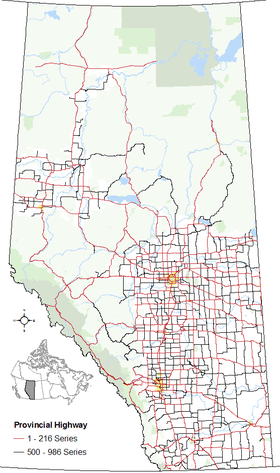
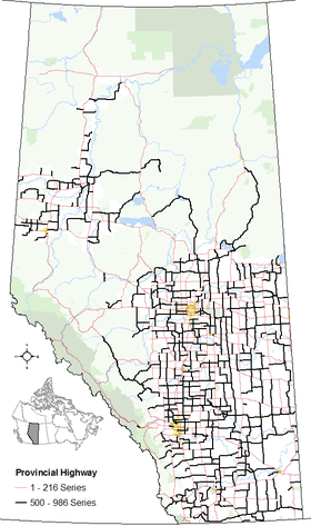
All of Alberta's provincial highways are maintained by Alberta Transportation (AT), a department of the Government of Alberta. The network includes two distinct series of highways. The "1 - 216" series of numbered provincial highways, formerly known as primary highways, makes up Alberta's core highway network. Highways within this series typically have the highest traffic volume and are mostly paved. The "500 - 986" series of numbered provincial highways provide more local access and include a higher proportion of gravel highways.
History
The province of Alberta abandoned its system of marking highways by different colours in 1926 in favour of a numbering system.[2] By 1928, the year a gravel road stretched from Edmonton to the United States border, Alberta's provincial highway network comprised 2,310 km (1,440 mi).[2]
Prior to 1973, the expanding provincial highway system in the province comprised one-digit and two-digit highways with some highway numbers having letter suffixes (e.g., Highway 1X, Highway 26A).[3] In 1973, a second highway system emerged. They were numbered using three digits starting in the 500s and referred to as secondary roads, while the pre-existing highway system continued to be referred to as provincial highways.[4] The following year, in 1974, the provincial highways were rebranded as primary highways,[5] while the secondary roads were rebranded as secondary highways in 1990.[6]
Secondary highways were abolished in 2000 with most of them becoming primary highways.[7] The expanded primary highway system was organized into two subsets – the former primary highways were organized into the 1 - 216 series[8] while the former secondaries were organized into the 500 - 986 series.[9] The primary highway terminology was subsequently abandoned in 2010 in favour of referring to all highways as provincial highways instead while maintaining the two series established a decade earlier.[10][11] Despite the changes in nomenclature in 2000 and 2010, the 1 - 216 series and the 500 - 986 series of highways are often still referred to as primary and secondary highways respectively.
1 - 216 series
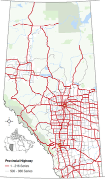

Alberta’s 1 to 216 series of provincial highways are Alberta’s main highways. They are numbered from 1 to 100, with the exception of the ring roads around Calgary and Edmonton, which are numbered 201 and 216 respectively. The numbers applied to these highways are derived from compounding the assigned numbers of the core north/south and east/west highways that intersect with the rings roads. In Calgary, Highway 201 is derived from the north/south Highway 2 and the east/west Highway 1. In Edmonton, Highway 216 is derived from the same north/south Highway 2 and the east/west Highway 16.
Within this series, all or portions of highways 1, 2, 3, 4, 9, 15, 16, 28, 28A, 35, 43, 49, 63, 201 and 216 are designated core routes of Canada’s National Highway System (NHS).[12] Highway 28 from Highway 63 to Cold Lake is designated a NHS feeder route and Highway 58 between Rainbow Lake and Highway 88 is designated a NHS northern/remote route.[12]
Highways 1, 2, 3, 4, 16, and 43 are considered Alberta’s most important interprovincial and international highways and are divided highways (expressways) or freeways for much or all of their length. Speed limits are generally 100 km/h (62 mph) except on some divided highways and freeways that are 110 kilometres per hour (68 mph) or segments of Highway 1 and Highway 16 through the national parks within Alberta's Rockies that can be 90 km/h (56 mph) or 70 km/h (43 mph).
The Highway 15/28A/28/63 corridor between Edmonton and Fort McMurray is considered one of Alberta’s most important intraprovincial highways. A twinning program is currently underway between Boyle and Fort McMurray. Highway 63 from Fort McMurray north to the Suncor and Syncrude oil sands operations is also twinned.
Although only Highways 1, 2, 3, 4, 15, 16, 43, 63, 100, 201, and 216 are twinned (expressways) for most of their length, the vast majority of Alberta's 1 to 216 series of highways are two-laned and paved. Only four highways within the series have segments that remained graveled. These include segments of Highways 40, 58, and 68 and a short segment near the northern terminus of Highway 63.[13]
| Contents |
|---|
X series
The roads in the X series are typically highways that are planned realignments or spurs of existing highways. The numbers applied to each highway in the X series are derived from the highway that is planned for realignment or spurred from (e.g. Highway 16X will be a realignment of Highway 16, and Highway 10X is spur from Highway 10).
| Marker | Hwy # | Status | Description | Length (km) |
|---|---|---|---|---|
| 1X | Proposed realignment |
A proposed Hwy 1 southwest bypass of Dunmore, Medicine Hat and Redcliff crossing Hwy 3, Hwy 523, the South Saskatchewan River and Hwy 524.[15] | 42.0[16] | |
2X |
2X | Proposed realignment |
A proposed Hwy 2 west bypass of Fort Macleod from Hwy 3 to Hwy 3X.[15] | unknown |
| Proposed realignment |
A proposed Hwy 2 east bypass of Nanton.[17] | unknown | ||
3X |
3X | Proposed realignment |
A proposed south bypass of Crowsnest Pass. From Hwy 3 at Crowsnest Lake to Hwy 3 near Blairmore passing south of Coleman.[18] | 17.0 |
| Proposed realignment |
A proposed realignment of Hwy 3, bringing it further south between Hwy 6 & Hwy 785, north of Pincher Creek.[17] | 6.1 | ||
| Proposed realignment |
A proposed south bypass of Fort Macleod.[15] | unknown | ||
| Proposed realignment |
A proposed north bypass of Lethbridge. From Hwy 3 & Range Road 230 west of Lethbridge, along Township Road 95, to Hwy 3 & Hwy 512.[17] | 38 | ||
4X |
4X | Proposed extension |
A proposed east bypass of Lethbridge. From Hwy 4 & Range Road 205 east of Lethbridge, along between Range Roads 205 & 210, to Hwy 3X east of Lethbridge.[17] | 15.3 |
6X |
6X | Proposed realignment |
A proposed east bypass of Pincher Creek. From Hwy 6 & Township Road 62 south of Pincher Creek, along Range Road 301 (Hwy 507), to Hwy 3X north of Pincher Creek.[17] | 6.1 |
11X |
11X | Proposed realignment |
A proposed north bypass of a portion of east Red Deer. From Hwy 11 (67 Street) & Range Road 272 (30 Avenue) in Red Deer, to Hwy 11 & Range Road 264 east of Red Deer.[17] | 7.4 |
16X |
16X | Proposed realignment |
A proposed south bypass of Hinton. From Hwy 16 & Hwy 40 west of Hinton, passing south of Hinton, to Hwy 16 east of Hinton.[17] | 12.0 |
| Proposed realignment |
A proposed south bypass of Edson. From Hwy 16 & 72 Street in Edson, passing south of Edson, to Hwy 16 east of Edson.[17] | 7.6 | ||
| Proposed realignment |
A proposed south bypass of Lloydminster. From Hwy 16 west of Lloydminster, along Township Road 491, to Hwy 17 (Saskatchewan border) south of Lloydminster.[17] | 12.6 | ||
| 22X | Constructed (potential realignment) |
A spur of Highway 22, Highway 22X (also Spruce Meadows Trail & Marquis of Lorne Trail) runs through south Calgary from Priddis east through Indus to Hwy 24. It is anticipated that this highway, along with Highway 901, will be renumbered either after the 22X/901 corridor is fully twinned, or after Calgary's ring road (Hwy 201) is completed. The Province is currently considering Highway 22X/901 as a potential realignment of Highway 1 between Calgary and Gleichen.[19] | 54 | |
40X |
40X | Proposed realignment |
A proposed southwest bypass of Grande Prairie from Hwy 43 west of Grande Prairie to Hwy 40 south of Grande Prairie interchange.[17] | unknown |
| 43X | Partially constructed (proposed realignment) |
A proposed northwest bypass of Grande Prairie. From Hwy 43 west of Grande Prairie, along Range Road 70 and Township Road 722, to existing Hwy 43 & Hwy 2 interchange.[17] The first 4 kilometres (2.5 mi) of the bypass from Range Road 63/116 Street to Hwy 43/2 opened to traffic on July 30, 2010, to a twinned standard.[20] | 13.5 | |
| Proposed realignment |
A proposed south bypass of Whitecourt. From Hwy 43 at 50 Avenue, north of Hwy 32 and McLeod River, along Beaver Creek, to Hwy 43 & Range Road 115.[17] | 8.9 | ||
500 - 986 series
| Contents
500 · 520 · 540 · 560 · 580 |
|---|
Alberta's 500 - 986 series of provincial highways are generally considered local or rural highways. The 500 - 986 series of provincial highways is divided into three sub-series:
- The 500/600 highways are west-east roads where the numbering increases northward from the Montana border to the Northwest Territories border.
- The 700/800 highways are south-north roads where numbering increases eastward from the British Columbia border to the Saskatchewan border.
- The 900 highways are newer or planned roads that have been established for future consideration as or as potential extensions or realignments of highways within the 1 - 216 series.
Some of these highways are paved, while others are entirely or partially gravel. Rural speed limits range from 80 km/h (50 mph) to 100 km/h (62 mph).
|


500
| Marker | Hwy # | Other names | Description | Length (km) |
|---|---|---|---|---|
| 500 | Two sections | •From Hwy 4 in Coutts, to Range Road 135 | 19.3 | |
| •From Hwy 501 north of Writing-on-Stone Provincial Park, through Aden, to Hwy 880 | 43 | |||
| 501 | 9 Avenue, Cardston; Centre Avenue, Milk River; Red Coat Trail | From Hwy 5 east of Mountain View, through Cardston & Milk River, to Saskatchewan Highway 13, follows the Red Coat Trail east of Hwy 889 | 301 | |
| 503 | From Hwy 5 east of Cardston, along the north side of Woolford Provincial Park, to Hwy 820 | 18.2 | ||
| 504 | From Hwy 4 & Hwy 36 in Warner, to Hwy 877 | 29 | ||
| 505 | From Hwy 6 south of Pincher Creek, to Hwy 5 in Spring Coulee | 72 | ||
| 506 | From Hwy 62 south of Magrath, to Hwy 4 through McNab north of Warner | 46 | ||
| 507 | Main Street, Pincher Creek | From Hwy 3 west of Lundbreck, through Pincher Creek, to Hwy 810 north of Glenwood | 73 | |
| 508 | From Hwy 5 south of Lethbridge, to Hwy 4 | 8.2 | ||
| 509 | From Hwy 2 in Stand Off, to Hwy 3 west of Coalhurst | 48 | ||
| 510 | From Hwy 3 in Cowley, north around Oldman River Reservoir, to Hwy 785 north of Pincher Creek | 24 | ||
| 511 | From Hwy 2 south of Fort Macleod, to Hwy 509 in Blood I.R. 148 | 28 | ||
| 512 | 1 Avenue S, Lethbridge | From Hwy 3 in Lethbridge, south around Coaldale, to Hwy 3 | 28 | |
| 513 | From Hwy 36 south of Taber, to Hwy 877 | 29 | ||
| 514 | From Range Road 41, along the north side of Cypress Hills Interprovincial Park, to Hwy 41 | 12.7 | ||
| 515 | From Hwy 41 north of Cypress Hills Interprovincial Park, to Saskatchewan Highway 724 | 25 | ||
| 519 | Rogers Avenue, Picture Butte | From Hwy 2 in Granum, through Nobleford & Picture Butte, to Hwy 845 | 65 | |
| 520 | 43 Avenue, Claresholm | From Hwy 22, through Claresholm & Barons, to Hwy 843 | 105 | |
| 521 | From Hwy 25 north of Turin, to Hwy 864 south of Vauxhall | 21 | ||
| 522 | From Hwy 843 north of Picture Butte, to Hwy 845 south of Lomond | 11.5 | ||
| 523 | From Range Road 84, to Hwy 3 in Medicine Hat | 26 | ||
| 524 | From Hwy 864, through Vauxhall & Hays, to Hwy 1 west of Redcliff | 106 | ||
| 525 | From Hwy 875 in Rolling Hills, to Hwy 524 | 28 | ||
| 526 | From Hwy 845, through Enchant, to Hwy 36 north of Vauxhall | 39 | ||
| 527 | From Willow Creek Provincial Park, to Hwy 2 in Stavely | 14.1 | ||
| 528 | From Hwy 41 north of Medicine Hat, to Saskatchewan Highway 728 | 19.4 | ||
| 529 | From Hwy 2 north of Stavely, to Hwy 845 south of Lomond | 78 | ||
| 530 | From Hwy 36 south of Scandia, to Hwy 875 north of Rolling Hills | 20 | ||
| 531 | From Hwy 842, to Hwy 845 in Lomond | 17.9 | ||
| 532 | From Hwy 40 north of Don Getty Wildland Provincial Park, to Hwy 22 | 26 | ||
| 533 | From Hwy 22, through Nanton, to Hwy 804 | 63 | ||
| 534 | Elizabeth Street, Vulcan | From Hwy 804 east of Nanton, through Vulcan, to Hwy 842 | 40 | |
| 535 | From Hwy 873 east of Lake Newell, to Hwy 876 south of Tilley | 16.6 | ||
| 537 | From Hwy 41 south of Hilda, to Saskatchewan Highway 371 | 6.5 | ||
| 539 | From Hwy 531 & Hwy 845 in Lomond, to Hwy 36 south of Brooks | 56 | ||
| 540 | From Hwy 22 south of Longview, to Hwy 2 north of Cayley | 35 | ||
| 541 | From Hwy 40 south of Elbow-Sheep Wildland Provincial Park, to Hwy 22 in Longview | 43 | ||
| 542 | •From Hwy 23 & Hwy 24 north of Vulcan, to Hwy 842 west of Milo | 23 | ||
| Cassils Road, Brooks | •From Hwy 36, to Hwy 1 in Brooks | 10.5 | ||
| 543 | From Hwy 22 south of Black Diamond, to Hwy 2A in High River | 25 | ||
| 544 | From Hwy 36 south of Duchess, to Hwy 884 | 57 | ||
| 545 | From Hwy 41, to Saskatchewan Highway 321 west of Burstall, Saskatchewan | 6.5 | ||
| 546 | Sunset Boulevard, Turner Valley | From Range Road 42, to Hwy 22 (Main Street) in Turner Valley | 30 | |
| 547 | 6 Avenue, Gleichen | From Hwy 2, Hwy 2A, & Hwy 7 north of Aldersyde, to Hwy 1 in Gleichen | 77 | |
| 549 | Elizabeth Street, Okotoks | From Range Road 44, to Hwy 2A (Northridge Drive) in Okotoks | 47 | |
| 550 | From Hwy 1 east of Bassano, through Rosemary, to Hwy 36 & Hwy 873 west of Duchess | 35 | ||
| 552 | Two sections | •From Hwy 2A at south Calgary limits, to Hwy 549 west of Okotoks | 13.0 | |
| •From Hwy 2 & Hwy 2A south of Calgary, to Hwy 547 & Hwy 799 east of Aldersyde | 33 | |||
| 555 | From Hwy 884 in Jenner, to Hwy 41 | 85 | ||
| 556 | From Hwy 862 south of Gem, to Hwy 36 north of Duchess | 19.0 | ||
| 560 | Glenmore Trail | From 84 Street SE (Range Road 290) at east Calgary limits, to Hwy 797 (Centre Street) in Langdon | 16.3 | |
| 561 | Two sections | •From Hwy 1 east of Strathmore, through Hussar, to Hwy 862 north of Gem | 69 | |
| •From Hwy 36, through Cessford, to Hwy 884 | 51 | |||
| 562 | From Hwy 41, to Saskatchewan border north of Empress | 13.6 | ||
| 563 | Old Banff Coach Road | From Hwy 1 at Range Road 31, to 101 Street SW (Range Road 24) at west Calgary limits. The maximum speed limit on this highway is 60 km/h | 6.2 | |
| 564 | Country Hills Boulevard, Calgary | From east Calgary limits, to Hwy 569 north of Wintering Hills | 126 | |
| 566 | From Hwy 772 north of Calgary & southwest of Airdrie, to Hwy 9 between Kathyrn and Keoma | 34 | ||
| 567 | Veterans Boulevard, Airdrie | From Hwy 22 north of Cochrane, through Airdrie, to Hwy 9 south of Irricana | 64 | |
| 569 | From Hwy 841 and Rosebud River east of Rosebud through Dalum to Hwy 10 & Hwy 570 in Drumheller | 28 | ||
| 570 | From Hwy 10 & Hwy 569 in Drumheller, to Saskatchewan Highway 44 north of Acadia Valley | 187 | ||
| 573 | From Hwy 10 in Drumheller, to Hwy 851 at Little Fish Lake Provincial Park | 24 | ||
| 574 | From Hwy 22 east of Bottrel, through Madden, to Hwy 2A in Crossfield | 33 | ||
| 575 | South Dinosaur Trail | From Hwy 791, through Acme & Carbon, to Hwy 9 & Hwy 56 in Drumheller. Part of the South Dinosaur Trail along the south side of the Red Deer River, from Hwy 837 to Hwy 9 (5 Street E) | 80 | |
| 576 | From Hwy 9 & Hwy 56 in Drumheller, to Hwy 851 | 29 | ||
| 577 | From Hwy 36 south of Hanna, to Sheerness Power Plant | 9.7 | ||
| 579 | From Hwy 40 & Hwy 734, through Water Valley, to Hwy 22 south of Cremona | 49 | ||
| 580 | From Hwy 22 in Cremona, to Hwy 2A south of Carstairs | 29 | ||
| 581 | From Hwy 2A in Carstairs, to Hwy 791 | 18.6 | ||
| 582 | 26 Avenue, Didsbury | From Hwy 22, through Didsbury, to Hwy 21 & Hwy 27 south of Three Hills | 90 | |
| 583 | 2 Street N, Three Hills | From Hwy 805, through Three Hills, to Hwy 836 | 36 | |
| 584 | Main Avenue, Sundre | From Hwy 734, to Hwy 22 (Center Street) & Hwy 27 in Sundre | 44 | |
| 585 | 1 Avenue, Trochu | From Hwy 21 in Trochu, to Hwy 56 between Morrin & Big Valley | 39 | |
| 586 | From Hwy 36 north of Hanna, to Hwy 884 south of Veteran | 67 | ||
| 587 | From Hwy 22 at James River Bridge, through Bowden, to Hwy 21 in Huxley | 98 | ||
| 589 | From Hwy 56 south of Big Valley, to Hwy 855 in Endiang | 39 | ||
| 590 | From Hwy 2 in Innisfail to Hwy 56 in Big Valley | 83 | ||
| 591 | From Hwy 734, to Hwy 22 & Hwy 54 west of Caroline | 31 | ||
| 592 | From Hwy 781, to Hwy 2A & Hwy 42 in Penhold | 15.3 | ||
| 593 | From Hwy 850 south of Botha, to Hwy 853 north of Byemoor | 16.1 | ||
| 594 | From Hwy 835 south of Erskine, to Hwy 56 south of Stettler | 11.3 | ||
| 595 | 19 Street, Red Deer; Delburne Road | From Hwy 2A (Gaetz Avenue), along the south side of Red Deer, to Hwy 21 north of Delburne | 38 | |
| 597 | From Hwy 2 west of Blackfalds, to Hwy 815 in Joffre | 21 | ||
| 598 | 52 Avenue, Rocky Mountain House | From Hwy 11, Hwy 22, & Hwy 752 in Rocky Mountain House, to Hwy 761 in Leslieville | 23 | |
| 599 | 50 Avenue, Castor | From Hwy 861 (45 Street) in Castor, to Hwy 41 south of Czar | 75 | |
600
| Marker | Hwy # | Other names | Description | Length (km) |
|---|---|---|---|---|
| 600 | From Hwy 41 south of Czar, to Hwy 13 & Hwy 899 in Provost | 43 | ||
| 601 | From Hwy 11 south of Alix, to Hwy 855 north of Halkirk | 77 | ||
| 602 | From Hwy 36 in Alliance, to Hwy 872 north of Brownfield | 28 | ||
| 603 | From Hwy 884, to Hwy 13 in Hughenden | 6.0 | ||
| 604 | From Hwy 792 east of Gull Lake, to Hwy 2A in Morningside | 18.8 | ||
| 605 | From Hwy 821, to Hwy 21 & Hwy 53 in Bashaw | 23 | ||
| 607 | From Hwy 761, to Hwy 20 south of Bluffton | 17.7 | ||
| 608 | •From Hwy 36 & Hwy 53 east of Forestburg, to Hwy 872 south of Hardisty | 28 | ||
| 49 Avenue, Amisk | •From Range Road 95 east of Battle River, to Hwy 884 in Amisk | 14.6 | ||
| 609 | 2 Street S, Edberg | From Hwy 21 north of Ferintosh, through Edberg, to Hwy 854 in Rosalind | 42 | |
| 610 | 49 Avenue, Edgerton; 5 Avenue, Chauvin | From Hwy 14 east of Wainwright, through Edgerton & Chauvin, to Hwy 17 & Saskatchewan Highway 680 | 49 | |
| 611 | From Hwy 20 at Hoadley, through Maskwacis, to Hwy 21 between Ferintosh & New Norway | 99 | ||
| 613 | 40 Avenue, Wetaskiwin | From Hwy 2A (56 Street) & Hwy 13 in Wetaskiwin, to Hwy 822 | 8.1 | |
| 614 | From Hwy 41 north of Wainwright, to Hwy 894 | 34 | ||
| 616 | From Range Road 71 in Buck Creek, through Breton, north around Pigeon Lake, through Pipestone & Millet, to Hwy 21 in Armena | 147 | ||
| 617 | From Hwy 21 in Hay Lakes, to Hwy 834 north of Round Hill | 28 | ||
| 619 | 51 Avenue, Viking | From Hwy 36 (54 Street) in Viking, to Hwy 17 south of Lloydminster | 126 | |
| 620 | From Brazeau Reservoir, through Lodgepole, to Hwy 22 in Drayton Valley | 53 | ||
| 621 | Center Avenue, Rocky Rapids | From Hwy 753 in Cynthia, to Hwy 22 in Rocky Rapids | 30 | |
| 622 | From Hwy 770, through Telfordville, to Hwy 39 north of Thorsby | 21 | ||
| 623 | Rollyview Road | From 50 Street in Leduc, to Hwy 617 south of Miquelon Lake Provincial Park | 48 | |
| 624 | From Hwy 22, to Hwy 759 south of Tomahawk | 14.3 | ||
| 625 | 20 Avenue, Nisku | From Hwy 2 & Hwy 19 in Nisku, to Hwy 21 east of Beaumont | 20 | |
| 626 | From Hwy 834 in Tofield, south around Beaverhill Lake, to Hwy 857 south of Vegreville | 43 | ||
| 627 | Garden Valley Road | From Hwy 759 north of Tomahawk, to 215 Street (Range Road 260) at west Edmonton limits | 70 | |
| 628 | 79 Avenue, Stony Plain; Whitemud Drive | •From Hwy 779 in Stony Plain, to 231 Street (Range Road 261) at west Edmonton limits | 19.1 | |
| •From Hwy 216 at east Edmonton limits, to Hwy 21 south of Sherwood Park. | 6.4 | |||
| 629 | From Hwy 824 north of South Cooking Lake (settlement), south of Half Moon Lake, north of Cooking Lake, to Range Road 212 in Collingwood Cove | 9.5 | ||
| 630 | Wye Road | From Sherwood Park Fwy & Anthony Henday Dr west of Sherwood Park, to Hwy 14 & Hwy 833 west of Tofield | 46 | |
| 631 | From Hwy 16 west of Vegreville, to Hwy 41 north of Vermilion | 90 | ||
| 633 | Villeneuve Road | From Hwy 757 west of Gainford, north around Isle Lake & south of Lac Ste. Anne, to Hwy 2 (St. Albert Trail) in St. Albert | 89 | |
| 640 | From Hwy 41 south of Elk Point, to Hwy 893 south of Heinsburg | 24 | ||
| 641 | From Hwy 897, through Tulliby Lake, to Hwy 17 & Saskatchewan Highway 797 in Onion Lake, Saskatchewan | 23 | ||
| 642 | 100 Avenue, Morinville | From Hwy 777 north of Onoway, past Sunrise Beach & through Sandy Beach at Sandy Lake (Lac Ste. Anne County), through Morinville, to Hwy 28 west of Bon Accord | 42 | |
| 643 | 53 Avenue, Gibbons | From Hwy 28A in Gibbons, to Hwy 38 south of Redwater | 21 | |
| 644 | 48 Avenue, Redwater | From Hwy 38 (44 Street) in Redwater, to Hwy 829 | 4.9 | |
| 645 | From Hwy 45 east of Andrew, to Hwy 860 at Sandy Lake (County of Two Hills) | 18.0 | ||
| 646 | From Hwy 29 & Hwy 36, through Lafond & Elk Point, along the south side of Whitney Lakes Provincial Park, to Hwy 897 south of Frog Lake | 88 | ||
| 647 | From Hwy 751, to Hwy 22 south of Mayerthorpe | 17.8 | ||
| 651 | 50 Avenue, Legal | From Hwy 33 north of Birch Cove, north around Lac la Nonne, through Busby & Legal, north around Lily Lake, to Hwy 28 west of Redwater | 82 | |
| 652 | From Hwy 857 north of Willingdon, through Saddle Lake, to Hwy 29 & Hwy 36 west of St. Paul | 40 | ||
| 654 | From Hwy 757 north of Sangudo, along Hwy 33 south of Barrhead, to Hwy 777 | 64 | ||
| 655 | From Range Road 70, north around Thunder Lake Provincial Park, to Hwy 18 east of Thunder Lake | 17.9 | ||
| 656 | From Hwy 18 & Hwy 63 east of Thorhild, to Hwy 831 north of Waskatenau | 14.7 | ||
| 657 | From Hwy 41 in Kehiwin I.R. 123, south around Muriel Lake, to Hwy 659 east of Bonnyville | 39 | ||
| 658 | From Hwy 43 south of Blue Ridge, to Hwy 33 west of Fort Assiniboine | 59 | ||
| 659 | 50 Avenue, Bonnyville | From Hwy 28 in Bonnyville, to Hwy 897 south of Cold Lake I.R. 149 | 27 | |
| 660 | From Hwy 881, through Glendon, to Hwy 28 east of Bonnyville | 40 | ||
| 661 | From Hwy 33 in Fort Assiniboine, along the north side of Fort Assiniboine Sandhills Wildland Provincial Park, through Dapp & Newbrook, to Hwy 831 | 160 | ||
| 663 | Taylor Road, Boyle; 88 Avenue Lac La Biche | From Hwy 44 in Fawcett, through Boyle & Lac La Biche, north around Lakeland Provincial Park, to Touchwood Lake | 201 | |
| 665 | From Hwy 43 south of Valleyview, to Hwy 747 | 30 | ||
| 666 | From Range Road 85, through Grovedale, to Hwy 40 south of Grande Prairie | 37 | ||
| 667 | From Hwy 722 south of Beaverlodge, to Hwy 43 | 6.6 | ||
| 668 | 37 Avenue, Grande Prairie | From 108 Street (Hwy 40), along the south side of Grande Prairie, to Resources Road (Range Road 60) | 3.4 | |
| 669 | From Hwy 49 in Valleyview, to Hwy 747 | 23 | ||
| 670 | 132 Avenue, Grande Prairie | From Hwy 40 (100 Street) in Grande Prairie, to Hwy 43 & Hwy 733 west of Bezanson | 30 | |
| 671 | From British Columbia border, through Goodfare, to Hwy 43 north of Beaverlodge | 33 | ||
| 672 | Emerson Trail | From Range Road 123, through Hythe, to Hwy 2 south of Sexsmith | 62 | |
| 674 | From Hwy 2 & Hwy 59 in Sexsmith, to Hwy 773 | 24 | ||
| 676 | From Hwy 736 north of DeBolt, to Hwy 49 north of Valleyview | 60 | ||
| 677 | From Hwy 724, through Woking, to Hwy 733 | 44 | ||
| 679 | From Hwy 49 south of Donnelly, along south side of Winagami Lake Provincial Park, to Hwy 750 north of Grouard | 69 | ||
| 680 | From Hwy 725 in Blueberry Mountain, to Hwy 727 north of Spirit River | 14.6 | ||
| 681 | From Hwy 719 north of Bonanza, through Silver Valley, to Hwy 725 | 48 | ||
| 682 | From Hwy 729, to Hwy 64 & Hwy 64A west of Fairview | 23 | ||
| 683 | From Hwy 744 south of Marie Reine, south of Greene Valley Provincial Park, to Hwy 2 in Nampa | 9.8 | ||
| 684 | Shaftesbury Trail (90 Street), Peace River | From Hwy 2 south of Grimshaw, along the north side of Peace River (river), to Hwy 2 in Peace River (town) | 31 | |
| 685 | 50 Avenue (Wilcox Road), Grimshaw | From Hwy 729, through Hines Creek, to Hwy 2 (51 Street) in Grimshaw | 87 | |
| 686 | From Hwy 88 in Red Earth Creek, north around Peerless Lake (lake), through Peerless Lake (hamlet), to Trout Lake | 89 | ||
| 688 | From Hwy 2 south of Peace River, to Hwy 986 | 24 | ||
| 689 | From Range Road 10, to Hwy 35 in Dixonville | 24 | ||
| 690 | From Hwy 35 south of North Star, to Hwy 743 in Deadwood | 11.3 | ||
| 691 | 10 Avenue SE, Manning | From Hwy 35 (Main Street) in Manning, to Hwy 741 | 14.9 | |
| 692 | From Hwy 35 north of Manning, to Range Road 210 | 27 | ||
| 695 | From Range Road 243 in Keg River, to Range Road 200 in Carcajou | 56 | ||
| 697 | From Hwy 35 north of Paddle Prairie, ferry across Peace River, through La Crete, to Hwy 88 west of Fort Vermilion | 119 | ||
700
| Marker | Hwy # | Other names | Description | Length (km) |
|---|---|---|---|---|
| 717 | From British Columbia border, through Bear Canyon, to Hwy 64 west of Cleardale | 24 | ||
| 719 | From Hwy 49, through Bonanza, to Hwy 681 | 13.5 | ||
| 721 | From Hwy 43 in Hythe, to Hwy 59 west of Valhalla Centre | 7.7 | ||
| 722 | 8 Avenue W, Beaverlodge | From Range Road 121, through Elmworth, to Hwy 43 in Beaverlodge | 36 | |
| 723 | From Hwy 43 east of Beaverlodge, to Hwy 59 in Valhalla Centre | 24 | ||
| 724 | From Hwy 43 at Wembley, through La Glace, to Hwy 677 | 47 | ||
| 725 | From Hwy 49, through Moonshine Lake Provincial Park & Blueberry Mountain, to Hwy 681 | 23 | ||
| 726 | From Hwy 64, to Township Road 870 in Worsley | 16.2 | ||
| 727 | From Hwy 49 west of Spirit River, to Hwy 680 | 19.9 | ||
| 729 | From Hwy 682 west of Fairview, to Hwy 685 west of Hines Creek | 16.5 | ||
| 730 | From Hwy 64, to Eureka River | 12.5 | ||
| 731 | From Hwy 677 west of Woking, to Hwy 49 in Spirit River | 21 | ||
| 732 | 113 Street, Fairview | From Hwy 2 (100 Avenue) & Hwy 64A in Fairview, to Hwy 685 east of Hines Creek | 17.0 | |
| 733 | From Hwy 43 & Hwy 670 in Bezanson, to Wanham north of Hwy 49 | 58 | ||
| 734 | Forestry Trunk Road | From Hwy 40 & Hwy 579 46 km from Hwy 1A, through the Rocky Mountains Forest, to Hwy 40 at Lovett River 11 km north of Elk River I.R. 233 & 105 km from Hwy 16 | 293 | |
| 735 | 3 Street W, Whitelaw | From Hwy 2 in Whitelaw, to Hwy 685 | 30 | |
| 736 | From Hwy 43 in DeBolt, to Hwy 676 | 30 | ||
| 737 | 1 Street, Brownvale | From Hwy 2 in Brownvale, north around Queen Elizabeth Provincial Park, to Hwy 35 north of Grimshaw | 35 | |
| 739 | 50 Street, Eaglesham | From Hwy 49, through Eaglesham, to Township Road 790 | 9.7 | |
| 740 | From Hwy 49, through Tangent, ferry across Peace River, to Hwy 684 south of Grimshaw | 55 | ||
| 741 | From Hwy 691 east of Manning, to Township Road 944 west of Notikewin Provincial Park | 36 | ||
| 742 | Spray Lakes Road; Three Sisters Parkway | From Spray Lakes Road & Ken Ritchie Way, through Canmore, to Hwy 1[21] | 8.2 | |
| 743 | 74 Street, Peace River | From Hwy 2, in Peace River, to Hwy 690 in Deadwood | 73 | |
| 744 | Judah Hill Road | From Hwy 676, through Girouxville & Marie-Reine, to Hwy 2 in Peace River | 95 | |
| 747 | From Hwy 665 east of Valleyview, to Hwy 2A west of High Prairie | 58 | ||
| 748 | 20 Avenue, Edson | •From Hwy 947, through Edson, to Hwy 32 north of Peers | 69 | |
| Spur (25 Street, Edson) | •From Hwy 16, to Hwy 748 (20 Avenue) in Edson | 1.5 | ||
| 749 | 48 Street, High Prairie | From West Prairie River, through High Prairie, to Hwy 679 east of Winagami Lake Provincial Park | 45 | |
| 750 | From Hwy 2 east of Enilda, through the Sucker Creek Cree First Nation & Atikameg, north around Utikuma Lake, to Hwy 88 south of Red Earth Creek | 104 | ||
| 751 | From Hwy 16, through MacKay, to Hwy 43 east of Whitecourt | 63 | ||
| 752 | 52 Avenue, Rocky Mountain House | From Hwy 734, to Hwy 11, Hwy 22, & Hwy 598 in Rocky Mountain House | 63 | |
| 753 | From Hwy 620 in Lodgepole, through Cynthia, to Hwy 16 west of Wildwood | 61 | ||
| 754 | From Hwy 88 north of Lesser Slave Lake Provincial Park, past Hwy 813, to Township Road 810 in Wabasca | 98 | ||
| 756 | From Hwy 11 west of Rocky Mountain House, to the south Crimson Lake Provincial Park limits | 3.4 | ||
| 757 | From Hwy 16 west of Gainford, through Sangudo, to Hwy 18 | 52 | ||
| 758 | White Avenue | From Hwy 66, through Bragg Creek Provincial Park, to Hwy 22 in Bragg Creek, west of the Tsuu T'ina Nation | 4.7 | |
| 759 | From Hwy 39, through Tomahawk, to Hwy 31 in Seba Beach | 40 | ||
| 760 | 5 Street SE, Sundre | From Township Road 320 in Bergen, to Hwy 22 (Main Avenue) in Sundre | 9.9 | |
| 761 | Two sections | •From Hwy 54 east of Caroline, through Leslieville, to Hwy 607 west of Bluffton. With a 3.2 km section still to be constructed over Weich Creek | 80 | |
| •From Hwy 13 east of Buck Lake, to Hwy 616 west of Breton | 16.7 | |||
| 762 | From Hwy 549 west of Millarville, west around Brown-Lowery Provincial Park, to Hwy 22 & Hwy 66 in Bragg Creek | 22 | ||
| 763 | From Hwy 655 north of Thunder Lake Provincial Park, to Hwy 33 south of Fort Assiniboine | 17.6 | ||
| 764 | From Hwy 43 in Cherhill, to Hwy 18 south of Thunder Lake Provincial Park | 30 | ||
| 765 | From Hwy 16, through Darwell, west around Lac Ste. Anne, to Hwy 43 west of Glenevis | 24 | ||
| 766 | Lochend Road; 48 Street, Eckville | From Hwy 1A west of Calgary, west around Gleniffer Lake, through Eckville, to Hwy 53 west of Rimbey. With a 4.1 km section still to be constructed over the Red Deer River | 171 | |
| 769 | From Hwy 18, north of Barrhead, through Neerlandia, to Hwy 661 | 23 | ||
| 770 | 50 Street, Warburg | From Hwy 616 east of Breton, through Warburg & Carvel, to Hwy 16 & Hwy 43 | 60 | |
| 771 | From Hwy 20 north of Bentley, west around Gull Lake & Pigeon Lake, to Hwy 616 | 80 | ||
| 772 | Symons Valley Road | From Township Road 261 (176 Avenue NW) at north Calgary limits, to Hwy 574 in Madden | 31 | |
| 774 | From Castle Mountain Resort, to Hwy 507 in Beaver Mines | 27 | ||
| 775 | From Beauvais Lake Provincial Park, to Hwy 507 west of Pincher Creek | 8.0 | ||
| 776 | From Hwy 18 between Barrhead & Westlock, to Hwy 661 between Neerlandia & Dapp | 19.4 | ||
| 777 | From Hwy 37 in Onoway, to Hwy 18 west of Westlock | 59 | ||
| 778 | 52 Street, Thorsby | From Hwy 616 north of Pigeon Lake, to Hwy 39 in Thorsby | 15.1 | |
| 779 | Fifth Meridian; 48 Street, Stony Plain | From Hwy 627, through Stony Plain, to Hwy 37 west of Calahoo | 30 | |
| 780 | From Hwy 13A east of Ma-Me-O Beach, to Hwy 616 east of Silver Beach | 8.4 | ||
| 781 | 50 Street, Sylvan Lake | From Hwy 54 northwest of Innisfail, to Hwy 11 at Sylvan Lake | 23 | |
| 783 | From Hwy 543 west of High River, to Hwy 2A & Hwy 7 in Okotoks | 11.3 | ||
| 785 | Macleod Street, Pincher Creek | From Hwy 6 (Waterton Avenue) in Pincher Creek, across the Oldman River Reservoir dam, north around Peigan I.R. 147, to Hwy 2 west of Fort Macleod | 63 | |
| 786 | From Hwy 507 east of Pincher Creek, to Hwy 3 in Brocket | 9.7 | ||
| 791 | From Hwy 22X in Indus, through Delacour, to Hwy 590 east of Innisfail | 130 | ||
| 792 | From Hwy 12 east of Gull Lake, to Township 454 north of the Battle River | 50 | ||
| 795 | 50 Street, Calmar | From Hwy 53 west of Ponoka, to Hwy 39 (50 Avenue) in Calmar | 72 | |
| 797 | •From Hwy 552, to the south bank of the Bow River | 2.9 | ||
| Centre Street, Langdon | •From Hwy 560 (Glenmore Trail) in Langdon, to Hwy 1 & Hwy 9 | 6.5 | ||
| 799 | From Hwy 23, through Blackie, to Hwy 547 & Hwy 552 east of Aldersyde | 16.2 | ||
800
| Marker | Hwy # | Other names | Description | Length (km) |
|---|---|---|---|---|
| 800 | From Hwy 5 west of Mountain View, through Hill Spring, to Hwy 505 | 21 | ||
| 801 | From Hwy 44 & Hwy 661, to the south Cross Lake Provincial Park limits | 32 | ||
| 803 | From Hwy 28 west of Bon Accord, to Hwy 651 east of Legal | 13.6 | ||
| 804 | From Hwy 533 east of Nanton, through Brant, to Hwy 23 | 24 | ||
| 805 | From Hwy 583, through Torrington & Wimborne, to Hwy 590 east of Innisfail | 36 | ||
| 806 | Pacific Avenue, Acme | From Hwy 9 & Hwy 72 in Beiseker, through Acme & Linden, to Hwy 583 west of Three Hills | 37 | |
| 808 | From Hwy 595 east of Red Deer, to Hwy 11 south of the Red Deer River | 4.7 | ||
| 810 | From Hwy 505 in Glenwood, to Hwy 3 west of Fort Macleod | 42 | ||
| 811 | 6 Avenue, Fort Macleod | From Hwy 2 & Hwy 3 in Fort Macleod, to Hwy 519 east of Granum | 17.5 | |
| 812 | From Hwy 663, to Hwy 2 east of Sunset Beach | 18.1 | ||
| 813 | 45 Street, Athabasca | From Hwy 2 (50 Avenue) in Athabasca, east around Calling Lake, west around Sandy Lake (M.D. of Opportunity), & north around South Wabasca Lake, through Calling Lake & Sandy Lake, to Hwy 754 in Wabasca | 172 | |
| 814 | 47 Street, Wetaskiwin; 50 Street, Beaumont | From Hwy 13 in Wetaskiwin, to Hwy 625 in Beaumont | 42 | |
| 815 | From Hwy 11 east of Red Deer, through Joffre, to Hwy 53 in Ponoka | 43 | ||
| 816 | From Hwy 590 through Pine Lake, to Hwy 595 east of Red Deer | 24 | ||
| 817 | Wheatland Trail, Strathmore | From Hwy 24 east of Carseland, through Strathmore, to Hwy 564 in Ardenode | 36 | |
| 820 | From Hwy 501 east of Cardston, to Hwy 5 west of Spring Coulee | 32 | ||
| 821 | From Hwy 12 in Tees, to Hwy 53 east of Ponoka | 23 | ||
| 822 | From Hwy 53 west of Bashaw, through Gwynne, to Hwy 616, east of Millet | 42 | ||
| 824 | From Hwy 14 west of South Cooking Lake, through Ardrossan, to Hwy 16 | 17.3 | ||
| 825 | From Hwy 37 west of Fort Saskatchewan, to Hwy 643 east of Gibbons. | 14.2 | ||
| 827 | 2 Street, Thorhild | From Hwy 28, through Egremont & Thorhild, to Hwy 55 east of Athabasca | 83 | |
| 829 | From Hwy 644 east of Redwater, to Hwy 28 & Hwy 63 west of Radway | 9.8 | ||
| 830 | From Hwy 630 east of Sherwood Park, through Josephburg, to Hwy 38 north of Bruderheim | 47 | ||
| 831 | 50 Av & 48 St, Lamont; Lakeview Road, Boyle | From Township Road 550 at the north Elk Island National Park limits, through Lamont, Star, & Waskatenau, west of Long Lake Provincial Park, to Hwy 63 & Hwy 663 (Taylor Road) in Boyle | 100 | |
| 833 | 53 Street, Camrose | From Hwy 13 (48 Avenue) in Camrose, to Hwy 14 & Hwy 630 west of Tofield | 44 | |
| 834 | 47 Street, Tofield | From Hwy 13 and Hwy 56 east of Camrose, through Round Hill & Tofield, west around Beaverhill Lake, to Hwy 15 in Chipman | 87 | |
| 835 | From Hwy 590 west of Big Valley, through Erskine, to Buffalo Lake at Rochon Sands | 48 | ||
| 836 | Rosebud Street, Carbon | From Hwy 9 west of Drumheller, through Carbon, to Hwy 585 east of Trochu | 59 | |
| 837 | South Dinosaur Trail | From Hwy 575 west of Drumheller, to Hwy 27 west of Morrin. Part of the South Dinosaur Trail along the west side of the Red Deer River, from Hwy 575 to Township Road 304 | 23 | |
| 838 | North Dinosaur Trail | From Hwy 9 & Hwy 56 (Bridge Street) in Drumheller, along the north side of the Red Deer River, Bleriot Ferry across the Red Deer River, to Hwy 837 | 26 | |
| 839 | From Hwy 27 west of Morrin, to Hwy 585 in Rumsey | 23 | ||
| 840 | From Hwy 561, through Standard & Rosebud, to Hwy 9 west of Drumheller | 41 | ||
| 841 | From Hwy 569 & Rosebud River east of Rosebud, to Hwy 9 west of Drumheller | 8.6 | ||
| 842 | From Hwy 529 north of Little Bow Provincial Park, west around McGregor Lake, through Milo, the Siksika Nation, Cluny, & Chancellor, to Hwy 564 | 118 | ||
| 843 | 43 Street, Lethbridge; 4 Street S, Picture Butte | From 62 Avenue N (Township Road 94) at north Lethbridge limits, through Picture Butte, to Hwy 552. With a 7.3 km section still to be constructed over the Oldman River | 45 | |
| 844 | From Hwy 506 west of the Milk River Ridge Reservoir, to Hwy 52 west of Raymond | 9.1 | ||
| 845 | Broadway, Raymond; 20 St, Coaldale; 1 Av, Lomond | From Hwy 52 (2 Avenue N) in Raymond, through Coaldale, to Hwy 531 & Hwy 539 in Lomond | 102 | |
| 846 | 1 Street, Stirling | From Hwy 52 east of Raymond, to Hwy 4 & Hwy 61 in Stirling | 6.9 | |
| 848 | From Hwy 564, through Dorothy, to Hwy 573 west of Little Fish Lake Provincial Park | 19.8 | ||
| 849 | From Hwy 10 in Drumheller, through Michichi, to Hwy 9 | 31 | ||
| 850 | From Hwy 593, through Botha & Red Willow, to Hwy 53 in Donalda | 51 | ||
| 851 | From Hwy 573 at Little Fish Lake Provincial Park, through the Hand Hills & Delia, to Hwy 589 west of Byemoor | 81 | ||
| 852 | From Hwy 12 in Gadsby, to Hwy 601 | 16.3 | ||
| 853 | From Hwy 589 in Byemoor, to Hwy 593 | 19.4 | ||
| 854 | 46 Street, Ryley | From Hwy 53 east of Donalda, through Rosalind, Bawlf, & Ryley, to Hwy 626 east of Beaverhill Lake | 91 | |
| 855 | Lougheed Av, Heisler; 45 St, Daysland; 54 St, Holden; Sawchuk St, Mundare; 50 St, Andrew & Smoky Lake | From Hwy 9 west of Hanna, through Endiang, Halkirk, Heisler, Daysland, Holden, Mundare, Andrew, & Smoky Lake, to Hwy 55 & Hwy 63 in Atmore | 389 | |
| 856 | 53 Street, Forestburg; Country Road, Strome | From Hwy 53 (44 Avenue) in Forestburg, to Hwy 13 in Strome | 26 | |
| 857 | Bruce Road; 50 Av & 60 St, Vegreville; 50 Av, Willingdon | From Hwy 26, through Bruce, Vegreville, & Willingdon, to Hwy 28 south of Bellis | 128 | |
| 858 | 100 Central Street, Plamondon | From Hwy 55, through Plamondon, north around Lac la Biche, to Hwy 881 north of Lac La Biche | 55 | |
| 859 | From Hwy 652 west of Saddle Lake, to Hwy 28 & Hwy 36 in Vilna | 15.7 | ||
| 860 | From Hwy 29 east of Hairy Hill, to Hwy 645 at Sandy Lake (County of Two Hills) | 9.1 | ||
| 861 | 45 Street, Castor | From Hwy 12 (48 Avenue) in Castor, through Galahad, to Hwy 53 east of Forestburg | 42 | |
| 862 | From Hwy 550 west of Rosemary, through Gem, Finnegan Ferry across the Red Deer River, to Hwy 9 west of Hanna | 115 | ||
| 864 | Park Road, Taber | From Hwy 3 (46 Avenue) in Taber, to Hwy 524 west of Vauxhall | 34 | |
| 866 | From Hwy 28 & Hwy 36 east of Spedden, to Hwy 55 south of Lac La Biche | 46 | ||
| 867 | From Hwy 28 east of Ashmont, to Hwy 55 | 39 | ||
| 869 | 50 Street, Sedgewick | From Hwy 608, to Hwy 13 in Sedgewick | 23 | |
| 870 | Main Street, Kinsella; 53 Street, Innisfree | From Hwy 13 in Lougheed, through Kinsella & Innisfree, to Hwy 45 east of Musidora | 111 | |
| 872 | From Hwy 586 west of Kirkpatrick Lake, through Coronation & Brownfield, to Hwy 13 west of Hardisty | 97 | ||
| 873 | 7 St E & 2 St W, Brooks; Railway Av, Duchess | From Range Road 162 in Rainier, east around Lake Newell, through Brooks & Duchess, to Hwy 36 & Hwy 550 | 60 | |
| 875 | From Hwy 36 south of Vauxhall, through Hays & Rolling Hills, to Hwy 1 west of Tilley | 82 | ||
| 876 | Centre Street, Tilley | From Hwy 535, through Tilley & Patricia, west around Dinosaur Provincial Park, through Wardlow & Cessford, to Hwy 570 south of Sunnynook | 100 | |
| 877 | Salvage Avenue, Grassy Lake | From Hwy 501 east of Milk River, through Skiff, to Hwy 3 (1 Street S) in Grassy Lake | 81 | |
| 879 | Main Street, Foremost | From Hwy 501, through Foremost, west of Bow Island, to Hwy 524 | 98 | |
| 880 | From Montana Secondary Highway 409 (Whitlash Road) at the Aden crossing, to Hwy 501 | 25 | ||
| 881 | 49 St, Hardisty; 53 St, Irma; 47 St, Mannville; 50 St, Myrnam; 40 St, St. Paul | •From Hwy 13 in Hardisty, through Irma, Mannville, Myrnam, St. Paul, & St. Vincent, to Hwy 55 | 216 | |
| 101 Avenue, Lac La Biche | •From Hwy 55 and Hwy 36 in Lac La Biche, east around Lac la Biche, west around the Cold Lake Air Weapons Range, through Conklin & Anzac, south around Gregoire Lake, through Gregoire Lake Provincial Park, to Hwy 63 south of Fort McMurray | 266 | ||
| 882 | 4 Street E, Glendon | From Hwy 28, through Glendon, to Hwy 660 | 9.7 | |
| 883 | From Hwy 14 west of Fabyan, to Hwy 41 north of Wainwright | 21 | ||
| 884 | 3 Street E, Youngstown | From Hwy 1 in Suffield, through Ralston, along the west side of CFB Suffield, through Jenner, Youngstown, & Veteran, to Hwy 13 in Amisk | 280 | |
| 885 | From Hwy 501 west of Pakowki Lake, through Etzikom, to Hwy 3 east of Bow Island | 76 | ||
| 886 | 1 Street W, Cereal; 44 Street, Consort | From Hwy 555 west of Buffalo, through Cereal, to Hwy 12 (48 Avenue) & Hwy 41 in Consort | 142 | |
| 887 | Red Coat Trail | From Hwy 501 east of Pakowki Lake, through Orion, to Hwy 3 in Seven Persons, follows the Red Coat Trail south of Hwy 61 | 77 | |
| 889 | From Hwy 501 east of Pakowki Lake, through Manyberries, to Township Road 70 | 29 | ||
| 892 | Main Street, Ardmore | From Hwy 659, through Ardmore, to Township Road 643 west of Cold Lake | 31 | |
| 893 | From Hwy 619, through Islay & Dewberry, to Hwy 646 in Heinsburg | 72 | ||
| 894 | 53 Street, Edgerton | From Hwy 610 (49 Avenue) in Edgerton, to Township Road 470 | 32 | |
| 895 | From Hwy 570, to Hwy 41 in Oyen | 14.4 | ||
| 897 | Two Sections | •From Hwy 14 north of Edgerton, through Paradise Valley, Kitscoty, Marwayne, & Frog Lake, east around Cold Lake I.R. 149, to Hwy 55 south of Cold Lake (city) | 186 | |
| •From the west CFB Cold Lake limits north of Beaver River, west around Cold Lake (lake), to where Township Road 651 would be west of Cold Lake Provincial Park | 23 | |||
| 899 | Two Sections | •From 3 Avenue in Empress to Hwy 562 | 2.0 | |
| •From Hwy 570 north of Acadia Valley, through Altario, Bodo, & Provost, to Hwy 610 west of Chauvin | 189 | |||
900
The roads in the 900 are typically highways that are planned realignments or extensions of existing highways. The numbers applied to each highway in the 900 series are derived from the highway that is planned to be realigned or extended (e.g. Hwy 901 is a potential reaignment of Hwy 1 and Hwy 986 is an extension of Hwy 686).
| Marker | Hwy # | Status | Description | Length (km) |
|---|---|---|---|---|
| 901 | Constructed (potential realignment) |
This is a continuation of Highway 22X (Marquis of Lorne Trail), from the intersection with Highway 24 east of Calgary, through the Siksika Nation, to Highway 1 east of Gleichen. It is anticipated that this highway, along with Highway 22X, will be renumbered either after the 22X/901 corridor is fully twinned, or after Calgary's ring road (Hwy 201) is completed. The Province is currently considering Highway 22X/901 as a potential realignment of Highway 1 between Calgary and Gleichen.[19] | 40 | |
| 921 | Proposed realignment |
From the intersection of Hwy 21 & Hwy 595 north of Delburne, across the Red Deer River, along Range Road 235, to Hwy 11.[17] | 10.8 | |
| Proposed realignment |
From Highway 11 (west of its current intersection with Highway 21) north along Range Road 223, to the intersection of Highway 21 & Highway 12 southeast of Alix.[17] | 4.6 | ||
| 947 | Constructed extension |
This alignment is a possible future extension of Highway 47, from Highway 43 east of Fox Creek, south to the Athabasca River. This resource road feeds traffic to the Kaybob South gas plant and other oil/gas facilities in the area. | 20 | |
| Proposed extension |
An extension of Highway 47 and Highway 947 from the intersection of Highway 47 & Highway 16 west of Edson, to the Athabasca River.[17] | 70 | ||
| 986 | Constructed extension |
This is a continuation of Highway 686, from Highway 35 north of Grimshaw, east north of Peace River, across the Peace River, through Cadotte Lake, Little Buffalo, and Loon Lake I.R., to Highway 88 south of Red Earth Creek and Highway 686. | 158 | |
Former highways
This is a list of defunct Alberta provincial highways. They have either been renamed, or are no longer provincially maintained.
| Current Marker | Former Name | Current Names | Description | Length (km) |
|---|---|---|---|---|
| Highway 1A | 17 Avenue SE; Chestermere Blvd | From Hwy 2 (Deerfoot Trail) in Calgary, east along 17 Avenue SE to Hwy 1 in Chestermere. Dropped by the province in 2013 and the Chestermere segment renamed Chestermere Blvd.[22] | 14 | |
| Highway 1A | Highway 93 (Icefields Parkway) | From Hwy 1 near Lake Louise to Hwy 16 in Jasper. Was renumbered to Hwy 93 in 1959. | 229 | |
| Highway 1B | Highway 93 (Banff-Windermere Parkway) | From Hwy 1 at Castle Junction to the British Columbia Border; the British Columbia segment was also Hwy 1B to Hwy 95 at Radium Hot Springs. Both Alberta and British Columbia segments were renumbered to Hwy 93 in 1959. | 11 | |
| Highway 2A | 10 Street SE, High River; 104 Street E; 1104 Drive E | From Highway 23 (12 Avenue SE) in High River, Hwy 2A went south through Cayley to Highway 2 north of Nanton. Was dropped by the province in 1997.[23][24] | 20 | |
|
Highway 14 | Highway 100 (Sherwood Park Fwy); | From Edmonton, east on Sherwood Park Fwy to Hwy 14X (now Hwy 216 & Anthony Henday Drive), then south to tie into the existing Hwy 14. In 1999, when Whitemud Drive was extended to Hwy 14, Sherwood Park Fwy was renumbered to Hwy 100 (unsigned) while the segment between Hwy 14X and Whitemud Drive was renumbered to Hwy 216;[25] and signed as part of Anthony Henday Drive in 2010. | 8.3 |
| Highway 14X | Highway 216 (Anthony Henday Dr) | From Hwy 14 (Sherwood Park Fwy) & Hwy 630 (Wye Road) between Edmonton & Sherwood Park, to Hwy 16A (now Baseline Road). Was extended to Hwy 16 (Yellowhead Hwy) when a segment of Hwy 16A was renumbered to Hwy 14X in 1996.[26] Was renumbered Hwy 216 when Whitemud Drive was extended to Hwy 14 in 1999,[25] and signed as a part of Anthony Henday Drive in 2010. | 6.4 | |
|
Highway 16A | Highway 216 (Anthony Henday Dr); | Hwy 16A from Hwy 16 (Yellowhead Hwy) between Sherwood Park and Edmonton south to Baseline Road, then west along Baseline Road to the Edmonton City Limits. Was dropped by the province where Baseline Road reverted to Strathcona County and the segment between Baseline Road and Hwy 16 became Hwy 14X in 1996,[26] and then Hwy 216 in 1999.[25] | 7.3 |
| Highway 16X | Highway 16 (Yellowhead Highway) | From Hwy 16 (now Hwy 16A & Parkland Highway) east of Carvel, through Spruce Grove, to Hwy 2 (170 Street) & Hwy 16 (Yellowhead Trail) in Edmonton. Renumbered from Highway 16X to Highway 16, when the original Highway 16 (through Stony Plain & Spruce Grove) was renumbered Highway 16A & Parkland Highway, in 1997.[27] | 36 | |
| Highway 17 | Highway 43 | Hwy 17 from Hwy 16 west of the Town of Stony Plain to the Town of Whitecourt was renumbered to Hwy 43 in the mid-1940s.[28][29] | 154 | |
| Highway 21A | Hwy 11 (D. Thompson Hwy); Twp Rd 390 | From Hwy 11 & Hwy 21, to Hwy 12 in Nevis, became part of Highway 11 in the 1990s. | 4.9 | |
| Highway 26 Highway 21A Highway 21 |
Highway 806; Highway 575; Highway 836 | Hwy 26 from Hwy 9 near the Village of Beiseker north to the Village of Acme, then east to the Village of Carbon, and then south back to Hwy 9 was de-designated in the early 1970/71.[30][31] Subsequently, the first two segments were re-designated as Hwy 806 and Hwy 575 in 1972/73[32][33] and the third segment was re-designated as Hwy 836 in 1993/94.[34][35] Prior to 1962/63, the portion of Hwy 26 from Hwy 21 to Hwy 9 via Acme was numbered Hwy 21A,[36][37] while prior to 1958/59, the portion of Hwy 21A from Hwy 21 to Hwy 9 via Acme was numbered Hwy 21.[38][39] |
53 | |
| Highway 28X | Highway 55 | Hwy 28X from Hwy 28 south of the City of Cold Lake to the Saskatchewan/Alberta border became part of Hwy 55 in the late 1970s concurrently when, or shortly after, the balance of Hwy 55 was designated from the City of Cold Lake to Athabasca.[40][41] | 13.6 | |
| Highway 29 | Range Road 15; Township Road 530 | From Spring Lake (formerly Edmonton Beach) to Highway 16A/Parkland Highway (formerly Highway 16) west of Stony Plain. Dropped by the province in the mid-1980s.[42][43] | 5.7 | |
| Highway 30 | Range Road 42; Range Road 35 | From Kapasiwin to Highway 16 east of Wabamun. Not picked up by the province in 2000. | 3.5 | |
| Highway 33 | Highway 633; Range Road 32 | Hwy 33 from Hwy 43 south of the Town of Onoway to Alberta Beach was renumbered from Hwy 33 to Hwy 633 in the early 1980s.[42][43] | 10.4 | |
| Highway 34 | Highway 43; Highway 49 | From Hwy 2 north of Grande Prairie at Four Mile Corner, through Bezanson and Debolt, to Hwy 43 in Valleyview. Became part of Highway 43, when 76 km section of Hwy 43 (Valleyview to Donnelly) became Highway 49, and 92 km section of Hwy 2 (BC border to Grande Prairie) became part of Hwy 43 on 1 March 1998.[44] | 104 | |
| Highway 38 | 156 Street NW | Hwy 38 from Stony Plain Road (formerly Hwy 16A) to 79 Avenue NW (now Whitemud Drive) serving the former Town of Jasper Place (now City of Edmonton) was de-designated in 1962/63.[45][46] | 3.2 | |
| Highway 40 | Highway 501; Range Road 241A | Hwy 40 from the Montana/Alberta border to Hwy 2 south of the Town of Cardston was renumbered to Hwy 501.[47][48] | 23.5 | |
| Highway 46 | Highway 63; Highway 55 | From Hwy 28 west of the Hamlet of Radway to the Hamlet of Lac La Biche. Segments became part of Hwy 63 and Hwy 55 in the late 1970s concurrently when, or shortly after, Hwy 55 was designated from the Saskatchewan/Alberta border to Athabasca.[49][50] | 153 | |
| Highway 48 | Highway 41 | From the Montana/Alberta border near Wild Horse to Hwy 1 west of the Hamlet of Irvine. Became part of Hwy 41 in the late 1970s or early 1980s.[51][52] | 114 | |
| Highway 51 | Highway 12; Township Road 404 | From Hwy 22 north of Rocky Mountain House, to Hwy 12 & Hwy 20 west of Bentley. Became part of Highway 12 when the original Highway 12 (from Bentley, through Rimbey and Breton, to Alsike) became part of Highway 20 in the 1980s. | 59 | |
| Highway 57 | Highway 22; Highway 39 | From Hwy 16 & Hwy 16A in Entwistle, through Drayton Valley, to Hwy 20 & Hwy 39 in Alsike. 55 km section became part of Highway 22, and 27 km section became part of Highway 39 in the 1970s. | 82 | |
| Highway 67 | Highway 88 (Bicentennial Hwy) | From Hwy 2 in Slave Lake, through Lesser Slave Lake Provincial Park, Red Earth Creek and Fort Vermilion, before crossing the Peace River, to Hwy 58. Renumbered Highway 88 in 1988. | 427 | |
| Highway 69 | Airport Road | From Fort McMurray at Highway 63 to the Lynton Canadian National rail yard. Transferred to the Regional Municipality of Wood Buffalo in 2014.[53] | 14.3 | |
| Highway 92 Highway 992 |
Highway 892 | Hwy 992 from Hwy 28 west of the Hamlet of Ardmore to northeast of Moore Lake, approximately 10 km (6.2 mi) north of Hwy 55, was renumbered to Hwy 92 in the early 1980s[54][55] and renumbered again to Hwy 892 in the mid-1980s.[56][57] | 24 | |
| Highway 517 | From Hwy 40 south of Bob Creek Wildland Provincial Park, along the south side of Oldman River, to Hwy 22. Not picked up by the province in 2000. | 22 | ||
| Highway 565 | Township Road 254 | From Hwy 895 (Range Road 43) south of Oyen, to Hwy 41 in Acadia Valley. Not picked up by the province in 2000. | 19.0 | |
| Highway 596 | Township Road 381 | From Hwy 781 south of Sylvan Lake, to Hwy 11 west of Red Deer. Dropped by the province in 2000s. | 18.2 | |
| Highway 615 | Highway 26; Township Road 470 | From Hwy 36 south of Viking, to Hwy 14 west of Kinsella. Became part of Highway 26 in 2009.[58] | 14.0 | |
| Highway 636 | Josephburg Rd; Twp Rd 550; North Av, Josephburg | From Hwy 15 in Fort Saskatchewan, to Hwy 830 in Josephburg. Not picked up by the province in 2000. | 7.7 | |
| Highway 637 | Highway 29; Township Road 554 | From Hwy 15 west of Lamont, through Hairy Hill, to Hwy 36 in Duvernay. Became part of Highway 29 in 2006.[59] | 75 | |
| Highway 649 | Hwy 654; Twp Rd 572/573 | From Hwy 757 north of Sangudo, along the north side of Pembina River, to Hwy 764. 6.9 km section became part of Highway 654, and 8.4 km section dropped by province. | 15.3 | |
| Highway 650 | Township Road 570 | From Hwy 33 north of Rich Valley, to Hwy 44 in Alcomdale. Not picked up by the province in 2000. | 34 | |
| Highway 720 | Rge Rd 123; Twp Rd 734; Rge Rd 125 | From Hwy 671 west of Goodfare, through Horse Lake I.R. 152B, to Hwy 43 west of Hwy 59. Not picked up by the province in 2000. | 22 | |
| Highway 734 | Forestry Trunk Road | Originally two sections, section from Hwy 40 east of Grande Cache, to Hwy 43 east of Grande Prairie, not picked up by the province in 2000. | 169 | |
| Highway 742 | Smith-Dorrien / Spray Trail, Kananaskis; (Spray Lakes Road, Canmore) | Originally 70 km, closed road section from Hwy 40 in Peter Lougheed Provincial Park, along the north side of Lower Kananaskis Lake & Smith-Dorrien Creek, along the east side of Spray Lakes, to Ken Ritchie Way at Canmore boundary, not picked up by the province in 2000.[21] | 62 | |
| Highway 745 | Little Smoky Road; Range Road 215 | From Hwy 43 in Little Smoky, to Hwy 665 south of Valleyview. Dropped by the province. | 29 | |
| Highway 746 | Range Road 200/195 | From Hwy 2A, 1.6 km concurrency with Hwy 679, to Hwy 2 (3 Avenue NW) in McLennan. Not picked up by the province in 2000. | 29 | |
| Highway 773 | 37 Street SW, Calgary | From Hwy 549 west of Okotoks, to Hwy 22X (Spruce Meadow Trail) at south Calgary limits. Dropped by the province in the 2000s. | 17.9 | |
| Highway 782 | Centre Street N, Calgary | From 144 Avenue N (Township Road 260), to Hwy 566 west of Balzac. Handed to Calgary when city limits expanded in 2007. | 3.2 | |
| Highway 788 | Golden Spike Rd; Calahoo Rd; Rge Rd 273 | From Hwy 628 west of Edmonton, through Spruce Grove, to Township Road 540 west of Villeneuve. Dropped by the province, and Hwy 16 crossing closed in the 2000s. | 12.9 | |
| Highway 794 | Hwy 44; Rge Rd 265/264; 104 Av, Westlock | From Hwy 16 west of Edmonton, through Villeneuve, Rivière Qui Barre, & Alcomdale, to Hwy 18 (100 Street) in Westlock. Became part of Highway 44 in 1999.[60] | 66 | |
| Highway 847 | Rge Rd 184; 11 St, Bassano | From Township Road 200, to Hwy 1 in Bassano. Not picked up by the province in 2000. | 15.2 | |
| Highway 940 | Hwy 40 (Bighorn Hwy); Forestry Trunk Rd | Unimproved sections of the Forestry Trunk Road. Became part of Highway 40 in 2000. |
Park access roads
A park access road (PAR) is an access route managed by Alberta Transportation that connects provincial parks to designated provincial highways.[61] The following is a list of all park access roads in Alberta as of May 2010.[17][62]
Urban approach roads
An urban approach road (UAR) is an access route managed by Alberta Transportation that connects urbanized areas to designated provincial highways.[61] The following is a list of all urban approach roads in Alberta as of May 2010.[17][62]
See also
References
- ↑ "Annual Report: 2008–2009" (PDF). Alberta Transportation. Retrieved 2011-01-01.
- 1 2 Chris Zdeb (February 22, 2014). "Feb. 22, 1928: Gravel road from Edmonton to U.S. border to be completed in a few months". Edmonton Journal. Postmedia Network Inc. Retrieved February 23, 2014.
- ↑ "Alberta 1972 Road Map". Surveys Branch, Department of Highways and Transport. 1972.
- ↑ "Alberta 1973 Road Map". Surveys Branch, Department of Highways and Transport. 1973.
- ↑ "Alberta 1974 Road Map". Surveys Branch, Department of Highways and Transport. 1974.
- ↑ "Alberta Road Map" (1990 ed.). Alberta Tourism. 1990.
- ↑ "Provincial Highway Service Classification – Final Report" (PDF). Alberta Transportation. November 2007. p. 1.5. Retrieved October 24, 2016.
It is noted that secondary highways ceased to exist by late 2000 and most were re-designated as primary highways.
- ↑ "Primary Highways 1 - 216 Progress Chart" (2006 ed.). Alberta Transportation. March 2006.
- ↑ "Primary Highways 500 - 986 Progress Chart" (2006 ed.). Alberta Transportation. March 2006.
- ↑ "Provincial Highways 1 - 216 Progress Chart" (2010 ed.). Alberta Transportation. March 2010.
- ↑ "Provincial Highways 500 - 986 Progress Chart" (2010 ed.). Alberta Transportation. March 2010.
- 1 2 Canada's National Highway System: Annual Report 2015 (PDF) (Report). Council of Ministers Responsible for Transportation and Highway Safety. September 2016. p. 29. Retrieved October 30, 2016.
- ↑ "Provincial Highways 1 - 216 Progress Chart" (PDF). Alberta Transportation. March 2015. Retrieved October 30, 2016.
- ↑ "Highway construction ramps up in northern Alberta". Alberta Transportation. 2009-05-28. Retrieved 2010-12-31.
- 1 2 3 Provincial Highways 1 - 216 Progress Chart (Map). Alberta Transportation. March 2014.
- ↑ "Highways 1 & 3 Network Functional Planning Study, Future Realignment, City of Medicine Hat: Executive Summary" (PDF) (PDF). November 20, 2008. p. E.16. Retrieved October 19, 2014.
- 1 2 3 4 5 6 7 8 9 10 11 12 13 14 15 16 17 2012 Provincial Highways 1 - 216 Progress Chart by Alberta Transportation.
- ↑ 2010 Provincial Highways 1 - 216 Progress Chart (map, 8 MB) by Alberta Transportation.
- 1 2 "County against re-alignment, not freeway status". Strathmore Standard. 2009-12-02. Retrieved 2009-12-04.
- ↑ Government of Alberta (2010-07-29). "New Grande Prairie bypass opens to traffic for long weekend". Retrieved 2010-08-01.
- 1 2 Town of Canmore Map of Highway 742
- ↑ "Highway 1A becomes Chestermere Boulevard". Town of Chestermere. June 17, 2013. Retrieved March 23, 2016.
- ↑ Province of Alberta Canada Official Road Map 1996 (Map). Alberta Tourism and Small Business. § M5
- ↑ Province of Alberta Canada Official Road Map 1997 (Map). Alberta Tourism and Small Business. § M5
- 1 2 3 Province of Alberta Canada Official Road Map 1999 (Map). Alberta Tourism and Small Business. § Edmonton
- 1 2 Province of Alberta Canada Official Road Map 1996 (Map). Alberta Tourism and Small Business. § Edmonton
- ↑ "Highways 16 and 16X Renumbered to Provide Greater Consistency". Government of Alberta. 1997-06-04. Retrieved 2009-09-10.
- ↑ Alberta Canada Official Road Map 1942 (Map). Department of Public Works. § D-7, E-7.
- ↑ Alberta Canada Official Road Map 1946 (Map). Department of Public Works. § D-7, E-7.
- ↑ Province of Alberta Canada Official Road Map 1970 (Map). Government of the Province of Alberta. § L-6.
- ↑ Province of Alberta Canada Official Road Map 1971 (Map). Government of the Province of Alberta. § L-6.
- ↑ Province of Alberta Canada Official Road Map 1972 (Map). Government of the Province of Alberta. § L-6.
- ↑ Province of Alberta Canada Official Road Map 1973 (Map). Government of the Province of Alberta. § L-6.
- ↑ Province of Alberta Canada Official Road Map (Map) (1993 ed.). Alberta Economic Development and Tourism. § L-6.
- ↑ Province of Alberta Canada Official Road Map (Map) (1994 ed.). Alberta Economic Development and Tourism. § L-6.
- ↑ Alberta Official Road Map (Map) (1962 ed.). Government of the Province of Alberta. § J-7, J-8.
- ↑ Alberta Official Road Map (Map) (1963 ed.). Government of the Province of Alberta. § J-7, J-8.
- ↑ Official Road Map of the Province of Alberta (Map) (1958 ed.). Department of Economic Affairs. § E-4, E-5.
- ↑ Official Road Map of the Province of Alberta (Map) (1959 ed.). Department of Economic Affairs. § E-4, E-5.
- ↑ Province of Alberta Canada Official Road Map 1976/77 (Map). Alberta Business Development and Tourism. § H-8.
- ↑ Province of Alberta Canada Official Road Map 1978/79 (Map). Alberta Business Development and Tourism. § H-8.
- 1 2 Province of Alberta Canada 1985 Official Road Map (Map). Alberta Tourism and Small Business. § I-5.
- 1 2 Province of Alberta Canada 1986 Official Road Map (Map). Alberta Tourism and Small Business. § I-5.
- ↑ "Primary Highway renumbering to take place in the Peace Region". Government of Alberta. 1998-02-24. Retrieved 2009-11-03.
- ↑ Alberta Official Road Map (Map) (1962 ed.). Government of the Province of Alberta. § F-7.
- ↑ Alberta Official Road Map (Map) (1963 ed.). Government of the Province of Alberta. § F-7.
- ↑ Province of Alberta Canada Official Road Map 1971 (Map). Government of the Province of Alberta. § O-6.
- ↑ Province of Alberta Canada Official Road Map 1972 (Map). Government of the Province of Alberta. § O-6.
- ↑ Province of Alberta Canada Official Road Map 1976/77 (Map). Alberta Business Development and Tourism. § H-6, H-7, I-6.
- ↑ Province of Alberta Canada Official Road Map 1978/79 (Map). Alberta Business Development and Tourism. § H-6, H-7, I-6.
- ↑ Province of Alberta Canada Official Road Map 1978/79 (Map). Alberta Business Development and Tourism. § N-8, O-8.
- ↑ Province of Alberta Canada Official Road Map 1980/81 (Map). Alberta Tourism and Small Business. § N-8, O-8.
- ↑ Aimee Harper (January 30, 2014). "Province, municipality sign off on land-road deal". Fort McMurray Today. Sun Media Community Newspapers. Retrieved July 16, 2016.
- ↑ Province of Alberta Canada Official Road Map 1980/81 (Map). Alberta Tourism and Small Business. § H-8.
- ↑ Province of Alberta Canada Official Road Map 1982 (Map). Alberta Tourism and Small Business. § H-8.
- ↑ Province of Alberta Canada 1985 Official Road Map (Map). Alberta Tourism and Small Business. § H-8.
- ↑ Province of Alberta Canada 1986 Official Road Map (Map). Alberta Tourism and Small Business. § H-8.
- ↑ "Media Release" (PDF). Beaver County. 2009-06-02. Retrieved 2009-09-14.
- ↑ "Travel to St. Paul made easier with new Highway 29 designation". Government of Alberta. 2006-10-10. Retrieved 2009-11-03.
- ↑ "Secondary Hwy 794 status changed". Government of Alberta. 1999-09-15. Retrieved 2009-09-10.
- 1 2 "Provincial Highway Service Classification – Final Report, November 2007" (PDF). Alberta Transportation. 2007-11-27. Retrieved 2011-02-28.
- 1 2 "2010 PMS Highway Summary Report, Data Year 2009" (PDF). Alberta Transportation. 2010-05-12. Retrieved 2011-02-28.
External links
|
| History | ||
|---|---|---|
| Politics | ||
| Geography | ||
| Communities | ||
| Economy |
| |
| Culture | ||
| ||