Medicine Hat
| Medicine Hat | |||||
|---|---|---|---|---|---|
| City | |||||
| City of Medicine Hat | |||||
|
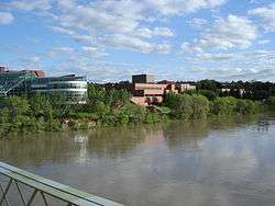
City hall, the courthouse and Medicine Hat Public Library are visible across the South Saskatchewan River, looking south from Finlay Bridge | |||||
| |||||
| Nickname(s): "The Hat", "The Gas City"[1] | |||||
|
Motto: Animo et Fide (Latin) "By Courage and Faith" | |||||
 Medicine Hat Location of Medicine Hat in Alberta | |||||
| Coordinates: 50°02′30″N 110°40′39″W / 50.04167°N 110.67750°WCoordinates: 50°02′30″N 110°40′39″W / 50.04167°N 110.67750°W | |||||
| Country | Canada | ||||
| Province | Alberta | ||||
| Region | Southern Alberta | ||||
| Census division | 1 | ||||
| Founded | 1883 | ||||
| Incorporated[2] | |||||
| • Village | May 31, 1894 | ||||
| • Town | November 1, 1898 | ||||
| • City | May 9, 1906 | ||||
| Government[3] | |||||
| • Mayor | Ted Clugston | ||||
| • Governing body |
| ||||
| • CAO (Municipal Services) | Merete Heggelund | ||||
| • MP |
Glen Motz –(Cons – Medicine Hat—Cardston—Warner) | ||||
| • MLAs |
Bob Wanner –(NDP – Medicine Hat) Drew Barnes –(WRP – Cypress-Medicine Hat) | ||||
| Area (2011)[4] | |||||
| • City | 112.01 km2 (43.25 sq mi) | ||||
| Elevation[5] | 690 m (2,260 ft) | ||||
| Population (2011)[4][6] | |||||
| • City | 60,005 | ||||
| • Density | 535.7/km2 (1,387/sq mi) | ||||
| • Urban | 65,671 | ||||
| • Municipal census (2015) | 63,018[7] | ||||
| Demonym(s) | Hatter[8] | ||||
| Time zone | MST (UTC−7) | ||||
| • Summer (DST) | MDT (UTC−6) | ||||
| Postal code span | T1A to T1C | ||||
| Area code(s) | 403, 587 | ||||
| Highways | 1, 3, 41A, 11A, 595 | ||||
| Waterways | South Saskatchewan River, Seven Persons Creek, Ross Creek | ||||
| Railways | Canadian Pacific Railway | ||||
| Website |
www | ||||

.png)
Medicine Hat is a city of 63,018 people in southeast Alberta, Canada. It is approximately 169 km (105 mi) east of Lethbridge and 295 km (183 mi) southeast of Calgary. This city and the adjacent Town of Redcliff to the northwest are surrounded by Cypress County.
It is situated on the Trans-Canada Highway (Highway 1), the eastern terminus of the Crowsnest Highway, and the South Saskatchewan River. Nearby communities considered part of the Medicine Hat area include the Town of Redcliff (abutting the city's northwest boundary) and the hamlets of Desert Blume, Dunmore, Irvine, Seven Persons, and Veinerville. The Cypress Hills (including Cypress Hills Interprovincial Park) is a relatively short distance (by car) to the southeast of the city.
Historically, Medicine Hat has been known for its large natural gas fields, being immortalized by Rudyard Kipling as having "all hell for a basement".[9][10] Because of these reserves, the city is known as "The Gas City". It is Alberta's sixth largest city. In October 2008, Medicine Hat was named one of Alberta's Top Employers by Mediacorp Canada Inc., which was announced by the Calgary Herald[11] and the Edmonton Journal.[12][13]
History
Name origins
The name "Medicine Hat" is the English translation of Saamis (SA-MUS) – the Blackfoot word for the eagle tail feather headdress worn by medicine men – or "Medicine Hat".[14] Several legends are associated with the name from a mythical mer-man river serpent named Soy-yee-daa-bee – the Creator – who appeared to a hunter and instructed him to sacrifice his wife to get mystical powers which were manifest in a special hat. Another legend tells of a battle long ago between the Blackfoot and the Cree in which a retreating Cree "Medicine Man" lost his headdress in the South Saskatchewan River.
A number of factors have always made Medicine Hat a natural gathering place. Before Europeans arrived, the Blackfoot, Cree and Assiniboine nations used the area for hundreds of years. The gently sloping valley with its converging waterways and hardy native cottonwood trees attracted both humans and the migratory bison herds which passed through the area.
Founding
In 1883, when the Canadian Pacific Railway (CPR) reached Medicine Hat and crossed the river a town site was established using the name from the First Nations legends. As the west developed, Medicine Hat became instrumental with the development of the first hospital past Winnipeg in 1889 and as a CPR divisional point. It was incorporated as a town on October 31, 1898, and as a city on May 9, 1906. Medicine Hat is halfway between Winnipeg and Vancouver.
Progress and growth
Rich in natural resources including natural gas, coal, clay, and farmland, the town was known in the early days as "the Pittsburgh of the West". A number of large industries located here, under the inducement of cheap and plentiful energy resources. Coal mines, brick works, pottery and glass bottle manufacturing plants, flour mills, etc. became established. The agricultural potential of the surrounding area, both in crop and livestock, also made the town a viable service centre with a well established transportation route. An economic boom was experienced between 1909–1914 bringing the population to over 10,000. Little growth occurred between the World Wars, although the population swelled in the mid-1940s due to the town hosting one of the largest Second World War P.O.W. camps in Canada. It was not until the 1950s that the town again experienced significant commercial development. Today, Medicine Hat prides itself as one of the most economical places to live in Canada, with its unique city-owned gas utility and power generation plant being predominant factors. Major industries have included chemical plants, a Goodyear tire and rubber plant, greenhouses, numerous oil and gas related companies, a foundry, I-XL Industries (a brickworks dating from the 1880s),[15] to name a few.


Geography
The Medicine Hat landscape is dominated by the South Saskatchewan River valley. In addition to this major river, both the Seven Persons Creek and Ross Creek empty into the South Saskatchewan River within the City of Medicine Hat boundary. The presence of these water bodies provide for a dramatic valley landscape with numerous cliffs, and finger coulees throughout the city. Beyond the city and river valley the land is flat to slightly rolling and is characterized by short-grass vegetation. Medicine Hat is also known as Canada's sunniest city.
Forty kilometres (about twenty-five miles) to the east at 50°0′38.2″N 110°6′48.3″W / 50.010611°N 110.113417°W lies the Badlands Guardian Geological Feature. It is a landscape formation taking the form of a head wearing a feathered headdress. The head is 1,000 feet (300 m) wide. It is in inverse relief, formed by valleys rather than raised ground.
Climate
Located in the steppe region known as Palliser's Triangle, Medicine Hat has a semi-arid, continental climate (Köppen climate classification BSk), with cold winters, and warm to hot, dry summers. Frequently, the winter cold is ameliorated by mild and dry chinook winds blowing from the west, and hot summer daytime temperatures are made more tolerable by low humidity and rapid cooling in the evening hours. Medicine Hat receives less precipitation annually than most other cities on the Canadian Prairies and plentiful sunshine (widely known as "The sunniest city in Canada"),[16] making it a popular retirement city. Maximum precipitation typically occurs in the late spring and early summer.
The highest temperature ever recorded in Medicine Hat was 42.2 °C (108 °F) on 12 July 1886.[16] The coldest temperature ever recorded was −46.1 °C (−51 °F) on 4 February 1887.[16]
| Climate data for Medicine Hat Airport, 1981−2010 normals, extremes 1883−present | |||||||||||||
|---|---|---|---|---|---|---|---|---|---|---|---|---|---|
| Month | Jan | Feb | Mar | Apr | May | Jun | Jul | Aug | Sep | Oct | Nov | Dec | Year |
| Record high humidex | 16.5 | 20.9 | 25.4 | 30.5 | 37.0 | 39.0 | 42.3 | 41.1 | 38.4 | 30.7 | 22.8 | 17.2 | 42.3 |
| Record high °C (°F) | 18.3 (64.9) |
21.1 (70) |
28.9 (84) |
35.6 (96.1) |
37.2 (99) |
41.7 (107.1) |
42.2 (108) |
41.1 (106) |
37.8 (100) |
33.9 (93) |
24.4 (75.9) |
20.0 (68) |
42.2 (108) |
| Average high °C (°F) | −2.8 (27) |
0.3 (32.5) |
6.1 (43) |
13.9 (57) |
19.3 (66.7) |
23.4 (74.1) |
27.5 (81.5) |
27.0 (80.6) |
20.5 (68.9) |
13.8 (56.8) |
4.0 (39.2) |
−1.4 (29.5) |
12.7 (54.9) |
| Daily mean °C (°F) | −8.4 (16.9) |
−5.5 (22.1) |
0.1 (32.2) |
7.0 (44.6) |
12.4 (54.3) |
16.7 (62.1) |
20.0 (68) |
19.3 (66.7) |
13.2 (55.8) |
6.9 (44.4) |
−1.8 (28.8) |
−7.0 (19.4) |
6.1 (43) |
| Average low °C (°F) | −14.1 (6.6) |
−11.3 (11.7) |
−6.0 (21.2) |
0.0 (32) |
5.4 (41.7) |
9.9 (49.8) |
12.4 (54.3) |
11.6 (52.9) |
5.9 (42.6) |
0.0 (32) |
−7.5 (18.5) |
−12.6 (9.3) |
−0.5 (31.1) |
| Record low °C (°F) | −46.1 (−51) |
−46.1 (−51) |
−38.9 (−38) |
−26.7 (−16.1) |
−11.1 (12) |
−1.1 (30) |
1.2 (34.2) |
−0.6 (30.9) |
−12.8 (9) |
−28.7 (−19.7) |
−37.8 (−36) |
−45.6 (−50.1) |
−46.1 (−51) |
| Record low wind chill | −54.2 | −50.7 | −44.5 | −31 | −12.6 | −2.9 | 0.0 | 0.0 | −12.8 | −37.6 | −49.2 | −58.9 | −58.9 |
| Average precipitation mm (inches) | 12.6 (0.496) |
7.7 (0.303) |
18.5 (0.728) |
20.4 (0.803) |
43.8 (1.724) |
65.4 (2.575) |
36.3 (1.429) |
34.2 (1.346) |
37.4 (1.472) |
19.1 (0.752) |
15.0 (0.591) |
12.1 (0.476) |
322.6 (12.701) |
| Average rainfall mm (inches) | 0.6 (0.024) |
0.4 (0.016) |
5.1 (0.201) |
14.4 (0.567) |
37.8 (1.488) |
65.4 (2.575) |
36.3 (1.429) |
33.8 (1.331) |
35.6 (1.402) |
12.3 (0.484) |
2.5 (0.098) |
0.8 (0.031) |
244.8 (9.638) |
| Average snowfall cm (inches) | 14.9 (5.87) |
9.2 (3.62) |
15.5 (6.1) |
6.3 (2.48) |
5.6 (2.2) |
0.0 (0) |
0.0 (0) |
0.4 (0.16) |
1.7 (0.67) |
6.9 (2.72) |
14.4 (5.67) |
13.3 (5.24) |
88.2 (34.72) |
| Average precipitation days (≥ 0.2 mm) | 7.7 | 6.3 | 8.4 | 7.3 | 10.2 | 10.9 | 8.3 | 6.9 | 7.6 | 5.8 | 7.3 | 7.9 | 94.7 |
| Average rainy days (≥ 0.2 mm) | 0.73 | 0.52 | 2.1 | 5.5 | 9.8 | 10.9 | 8.3 | 6.9 | 7.4 | 4.4 | 1.8 | 0.84 | 59.2 |
| Average snowy days (≥ 0.2 cm) | 7.8 | 6.4 | 7.0 | 2.9 | 1.4 | 0.0 | 0.0 | 0.04 | 0.46 | 2.2 | 6.4 | 7.7 | 42.2 |
| Mean monthly sunshine hours | 110.0 | 138.1 | 174.2 | 240.3 | 282.8 | 303.4 | 353.5 | 323.9 | 221.4 | 181.5 | 114.6 | 98.6 | 2,544.3 |
| Percent possible sunshine | 41.2 | 48.6 | 47.4 | 58.3 | 59.3 | 62.5 | 71.7 | 72.3 | 58.3 | 54.3 | 42.0 | 38.9 | 54.6 |
| Source: Environment Canada[16] | |||||||||||||
Neighbourhoods
- Cottonwood – A community located above the Cottonwood golf course, between the light industrial area and the airport. Overlooks the World's Largest Teepee.
- Crescent Heights – Mainly built in the 1950s through to the 1960s. Located on the north side of city on the entire hill above the river valley.
- Crestwood and Norwood – This is an older area of town mainly built in the 1950s. It is located on a plateau southeast of the South Flats and the Seven Person's Creek. The Medicine Hat Stampede and Exhibition centre is within this area.
- Hamptons - A four-phase neighbourhood approved for development in 2005. It is located in south Medicine Hat, and is bounded by South Boundary Road to the south, 13 Avenue SE to the east, South Vista Heights to the west and Southridge to the north. It features architectural controls implemented by the developer.[17]
- North Flats – The oldest area in Medicine Hat. Located northeast of the CPR marshaling yards near the South Saskatchewan River and downtown. An inner-city neighbourhood that is home to residential and industrial uses. This area is in the east valley.
- Park Meadows – An area that was developed in the 1990s, adjacent to Crestwood. Primarily residential with several apartments.
- Parkview – A subdivision developed in the 1990s, and located north of the South Saskatchewan River. It is adjacent to Police Point Park and Medicine Hat Golf and Country Club.
- Ranchlands – A neighbourhood developed in the mid 2000s and located in the northeast sector of the city. The neighborhood includes residential lands both above and in the South Saskatchewan River valley.
- River Heights – Located on the Southwest Hill north of the hospital, and south of the South Saskatchewan River. Includes River Heights Elementary School and an extended care wing, which was originally a part of the hospital.
- Riverside – A mature inner-city neighbourhood along the north bank of the South Saskatchewan River. The community has experienced gentrification. Mature trees and boulevards line the streets.
- Ross Glen – Low density middle-class neighbourhood located in the southeast end of the city.
- Saamis Heights – Located west of South Ridge in the south sector of the city. Saamis Heights was developed in under five years. The community borders the Seven Person's Creek valley and thus provides some walkout view lots.
- South Flats – Located south of the CPR marshaling yard, also in the valley, and adjacent to downtown.
- South Ridge – The first residential development south of the Trans Canada Highway. First developed in the late 1970s. Adjacent to the World's Largest Teepee.
- South Vista Heights – A new residential suburban community south of the Trans Canada Highway.
- Southeast Hill – One of the oldest areas of the city. It originally overlooked downtown on the north side of the hill and Kin Coulee on the south side. Originally this area housed CPR workers. It is home to four schools.
- Southlands – A community that opened in 2007. It is home to a significant regional commercial centre including Wal-Mart, Staples, Canadian Tire and Home Depot. The residential community includes parks, future school sites, many low residential lots, and several large multi-family sites.
- Southview – Located in the southeast part of the city between Ross Glen and Crestwood.
- Southwest Hill – Located west of Division Avenue next to the SE Hill area. It is home to five schools and the city's hospital.
Housing
The average home price in Medicine Hat as of the end of September 2012 was $258,535.[18]
Demographics
| Federal census population history | ||
|---|---|---|
| Year | Pop. | ±% |
| 1901 | 1,570 | — |
| 1906 | 3,050 | +94.3% |
| 1911 | 5,608 | +83.9% |
| 1916 | 9,272 | +65.3% |
| 1921 | 9,634 | +3.9% |
| 1926 | 9,536 | −1.0% |
| 1931 | 10,300 | +8.0% |
| 1936 | 9,592 | −6.9% |
| 1941 | 10,571 | +10.2% |
| 1946 | 12,859 | +21.6% |
| 1951 | 16,364 | +27.3% |
| 1956 | 20,826 | +27.3% |
| 1961 | 24,484 | +17.6% |
| 1966 | 25,574 | +4.5% |
| 1971 | 26,518 | +3.7% |
| 1976 | 32,811 | +23.7% |
| 1981 | 40,380 | +23.1% |
| 1986 | 41,804 | +3.5% |
| 1991 | 43,625 | +4.4% |
| 1996 | 46,783 | +7.2% |
| 2001 | 51,249 | +9.5% |
| 2006 | 56,997 | +11.2% |
| 2011 | 60,005 | +5.3% |
| Source: Statistics Canada [19][20][21][22][23][24][25][26][27][28][29] [4][30][31][32][33][34][35][36][37][38][39] | ||
The population of the City of Medicine Hat according to its 2015 municipal census is 63,018,[7] a 3% change from its 2012 municipal census population of 61,180,[40]
In the 2011 Census, the City of Medicine Hat had a population of 60,005 living in 25,445 of its 27,342 total dwellings, a 5.3% change from its 2006 population of 56,997. With a land area of 112.01 km2 (43.25 sq mi), it had a population density of 535.7/km2 (1,387.5/sq mi) in 2011.[4] Also in 2011, the Medicine Hat population centre had a population of 65,671,[41] while the Medicine Hat census agglomeration had a population of 72,807.[42] The population centre includes the adjacent Town of Redcliff to the northwest and a small portion of Cypress County to the east[43] that includes the Hamlet of Veinerville,[44] while the census agglomeration includes Redcliff and Cypress County in its entirety.[45]
In 2006, Medicine Hat had a population of 56,997 living in 24,729 dwellings, an 11.2% increase from 2001. The city has a land area of 112.01 km2 (43.25 sq mi) and a population density of 508.9/km2 (1,318/sq mi).[46]
More than 89 percent of residents identified English as their first language at the time of the 2006 census, while 6 percent identified German and just over 1 percent each identified Spanish and French as their first language learned. The next most common languages were Ukrainian, Chinese, Dutch, and Polish.[47]
More than 79 percent of residents identified as Christian at the time of the 2001 census while almost 20 percent indicated they had no religious affiliation. For specific denominations Statistics Canada counted 16,175 Roman Catholics (26.5 percent), 9,445 members of the United Church of Canada (15.5 percent), and 6,170 Lutherans (slightly more than 10 percent).[48] Less numerous denominations included 3,780 Anglicans (more than 6 percent), 1,745 members of the Evangelical Missionary Church (almost 3 percent), 1,470 Baptists (over 2 percent), 1,220 identifying as Pentecostal (2 percent), 1,220 Latter-day Saints (2 percent), and 675 Presbyterians (just over 1 percent).
Attractions

The Medicine Hat Clay Industries National Historic District[49] is a living, working museum that offers a unique and extensive experience through collections, exhibits, interpretation, guided tours and educational and artistic programming. The Medalta Potteries and Hycroft China Factory Complexes are the focal points in this 150-acre (0.6 km2) region. This nationally recognized industrial historic district is a cultural initiative of the Friends of Medalta Society with Federal, Provincial, Municipal and Private support. Restoration, preservation and cultural development of the Medicine Hat Clay Industries National Historic District for the purpose of education and public enjoyment is ongoing.[50]
Just south of the Trans-Canada Highway and overlooking the Blackfoot buffalo jump is the world's tallest teepee, the "Saamis Teepee". Designed for the 1988 Winter Olympics in Calgary as a symbol of Canada's Aboriginal heritage, it was moved to Medicine Hat in 1991. It stands over 20 stories high and was designed to withstand extreme temperatures and winds up to 240 km/h (150 mph). During a January 2007 windstorm, a portion of the teepee was damaged. Upon further inspection, it was discovered that extensive weathering was partially to blame. After repairs were complete, the Saamis Teepee now stands approximately 15 feet (4.6 m) shorter.
The Medicine Hat Family Leisure Centre is the largest indoor multi-purpose facility in the city. The building is 90,000 sq ft (8,000 m2) and is sited on 57 acres (230,000 m2) in the north end of the city. The facility includes an Olympic-sized ice rink, 50m pool, waterslide, diving platforms, kiddies pool, wave pool and cafe. It is currently undergoing an extensive renovation to include an indoor soccer facility, track and improved fitness centre. The improvements will almost double the size of the facility. In the area surrounding the Leisure Centre facility there are several other sporting venues including; 4 ball diamonds, lighted football field, 3 soccer pitches and one of the largest BMX racing facilities in Southern Alberta.
Located in downtown Medicine Hat, The Esplanade[51] is a large multi purpose cultural centre. The facility features a 700+ seat performing arts theatre, art gallery, museum, archives, gift shop, and cafe. The Esplanade officially opened in October 2005.
The Medicine Hat Drag Racing Association[52] is located just off the Trans Canada Highway on Boundary Road or the spectators entrance on Box Springs Road. This is Alberta's only sanctioned NHRA track and is a 1/4 mile in length. The facility proudly supports affordable family entertainment and encourages people to race the strip, not the street. The seasons typically run from May till September hosting a variety of events from jet and alcohol cars, bracket racing and the NHRA National open which attracts approx. 300+ cars from all over North America.
Medicine Hat Public Library is located across the street from The Esplanade. It has over 10,000 annual members and is the resource library for the Shortgrass Library System[53] of Southern Alberta.
Parks
There are over 100 kilometres (62 mi) of walking trails in the city. All of the major parks are linked by the extensive trail system.

- Police Point Park was an early North-West Mounted Police outpost, and the park is now a 300-acre (1.2 km2) nature-lovers' dream with shale paths next to the South Saskatchewan River. It is also one of Southern Alberta's well known birding destinations. The park encompasses The Medicine Hat Interpretive Program building, where they run programs and inform the public about the happenings of nature around the city.
- Strathcona Island Park is located along the south bank of the South Saskatchewan River. The park has 5 kilometres (3.1 mi) of walking trails, playgrounds, a water park, ball diamonds, a pavilion centre, washrooms, ice skating, kitchens and fire pits. The park is heavily treed.
- Kin Coulee Park is located along the banks of the Seven Persons Creek. This 100-acre (0.4 km2) park is almost entirely manicured. The park features a skateboard park, 2 ball diamonds, beach volleyball courts, fire pits, a band shell, washrooms, and 2 playgrounds. It's also the venue for the annual Canada Day festival and fireworks.
- Echodale Regional Park is a 650-acre (2.6 km²) park that includes an artificial swimming lake. Amenities include a beach, walking trails, fire pits, canoe rentals, paddle boats, snack bar, washrooms and historic ranch.
- Central Park – located in the Southeast Hill neighborhood – is surrounded by large cottonwood trees and, on the north side, a row of cedar trees. It also has play structures and a spray-deck. A street basketball court can be found here, which is usually in full use during the summer months.
- Riverside Veterans' Memorial Park – located downtown across River Road from the South Saskatchewan river and across 6th Avenue from city hall – is home to the city's Cenotaph, a WWII era Sherman tank, a brick mural by James Marshall and two Canadian Pacific Railway locomotives.

Sports
The city is home to the Medicine Hat Tigers, a major junior ice hockey team in the Western Hockey League (WHL). Established in 1970, the team has won seven division titles, five WHL league championships and back-to-back Canadian Hockey League (CHL) Memorial Cups in 1987 and 1988 in its history. Numerous Tigers alumni moved on to play in the National Hockey League (NHL). Lanny Mc Donald played WHL hockey for the Medicine Hat Tigers. He played in 1971-1972 and scored 50 goals and assisted on 64 goals. In 1972-1973 seasons he scored 62 goals and 77 assists.[54]
The city is also home to the Medicine Hat Mavericks, a summer collegiate baseball team in the Western Major Baseball League (WMBL). Established in 2003, the team plays at Athletic Park stadium in downtown Medicine Hat.
Government
LaVar Payne has served as Member of Parliament for Medicine Hat since October 2008, and was re-elected in 2011. He announced in 2014 that he would not be running in the next election in October 2015. The previous MP was Monte Solberg. Both Payne and Solberg are members of the Conservative Party of Canada. Medicine Hat has two provincial ridings. One is named Medicine Hat, and is represented by the New Democratic Party (NDP), while the other one is named Medicine Hat-Cypress, and is represented by the Wildrose Party.[55]
Infrastructure
Alberta Transportation is currently negotiating with landowners south of the city to secure land for the future Highway 1 (Trans-Canada Highway) bypass.[56] The bypass is expected to be constructed in the next 10–20 years.
The city owns the gas production, gas distribution, electric generation and electric distribution utilities that serve the citizens. The city-owned gas utility is the 30th largest natural gas producer (by volume produced) in Canada.
The city is working on design of the South-West Sector Sanitary Trunk main, extension of South Boundary Road from Strachan Road to Southridge Drive, and a South-West Sector water transmission line. This infrastructure will accommodate the development of new residential communities west of South Ridge Dr, and south of the Seven Persons Creek.
The city is served by the Medicine Hat Airport and Medicine Hat Transit.
Acute medical care is provided to residents at Medicine Hat Regional Hospital.[57]
Beginning in 2009, several ICT business leaders began working together to facilitate economic growth and diversify the local economy by building a robust community network based on fiber optic technologies.
Education
Medicine Hat School District No. 76 has been serving the needs of public school students since it came into existence in 1886. The District has five trustees and comprises three secondary schools, Alexandra Middle School (formerly Alexandra Junior High School), Crescent Heights High School and Medicine Hat High School, 12 elementary (K–6) schools, a special needs school for the severely disabled, as well as an Alternative School program which incorporates a joint partnership with the YMCA Teen Moms' Program, YMCA Stay-in-School Program, a program with the former Palliser Health Region for secondary students and a program supported by Alberta Children Services for students with behavioural needs. French immersion programming is provided as an option. The District currently works with BHTH Instituation for Education to operate an international educational program in China and 3 schools have joined this program, such as Tangshan Caofeidian #2 School, Qinhuangdao Foreign Language School, and Shandong Weifang Middle School.
The Medicine Hat Catholic/Separate School District provides educational programming for students from kindergarten through Grade 12. French immersion programming is provided as an option in select District schools. It operates one high school, Monsignor McCoy, and nine other schools.[58]
Medicine Hat also has a Francophone school, École Les Cyprès,[59] and a public/charter school, the Centre for Academic and Personal Excellence (CAPE).
The Medicine Hat College is located in south Medicine Hat. The first students were accepted to the college in 1965. Now with over 2,500 students and three campuses, the college has grown into an integral part of the community. The Medicine Hat College Rattlers athletic program include basketball, volleyball, golf, soccer and futsol.
Media
Medicine Hat has several radio and television stations broadcasting from it, as well as a few distant AM radio stations from Calgary. Medicine Hat News publishes a daily newspaper.[60]
Military
Medicine Hat is home to the South Alberta Light Horse (SALH), an army reserve unit. The SALH dates back to 1885 when it took part in the North-West Rebellion. Since then it has gained battle honours in the First and Second World Wars and today its members continue to serve overseas on United Nations and North Atlantic Treaty Organization missions. Currently the SALH has members serving in Afghanistan.
Medicine Hat was also home to a British Commonwealth Air Training Plan airfield and a POW camp during the Second World War.
Canadian Forces Base Suffield is located 50 kilometres (31 mi) west of the city. It is estimated that the base contributes C$120 million annually to the local economy, principally through its two lodger units: British Army Training Unit Suffield, and Defence Research and Development Canada – Suffield).
Notable people
- Jurgen Gothe, radio broadcaster[61]
- Richard Hortness, Olympic swimmer[62]
- Trevor Linden, former professional hockey player, member of the Order of Canada, president of hockey operations for Vancouver Canucks[63] and recipient of the Order of British Columbia[64]
- Jess Nowicki, Canadian Railroad Hall of Fame Inductee[65]
- Bud Olson, former Member of Parliament and Senator for Medicine Hat, former Lieutenant Governor of Alberta[66]
- Chris Osgood, former professional hockey player[67]
- Kenneth Sauer, former public schools superintendent, city alderman and member of the Order of Canada and the Alberta Order of Excellence[68][69]
- Richard Edward Taylor, co-recipient of the 1990 Nobel Prize for Physics[70]
- Arnold Tremere, Executive Director of the Canadian International Grains Institute (government official)[71]
- Tommy Tweed, playwright, actor, broadcaster, recipient of the John Drainie Award, and officer of the Order of Canada[72]
- Amanda (Falk) Cook, singer and worship leader with Bethel Music and winner of eight GMA Covenant Awards[73]
- Jadyn Wong, actress known for her role as Happy in the American TV series Scorpion.
See also
References
- ↑ Peggy Revell (February 8, 2012). "Deputy premier tours Hat's projects". Medicine Hat News. Alberta Newspaper Group Limited Partnership. Retrieved June 6, 2012.
- ↑ "Location and History Profile: City of Medicine Hat" (PDF). Alberta Municipal Affairs. June 17, 2016. p. 92. Retrieved June 18, 2016.
- ↑ "Municipal Officials Search". Alberta Municipal Affairs. November 18, 2016. Retrieved November 21, 2016.
- 1 2 3 4 "Population and dwelling counts, for Canada, provinces and territories, and census subdivisions (municipalities), 2011 and 2006 censuses". Statistics Canada. February 8, 2012. Retrieved February 8, 2012.
- ↑ "Alberta Private Sewage Systems 2009 Standard of Practice Handbook: Appendix A.3 Alberta Design Data (A.3.A. Alberta Climate Design Data by Town)" (PDF) (PDF). Safety Codes Council. January 2012. pp. 212–215 (PDF pages 226–229). Retrieved October 8, 2013.
- ↑ "Population and dwelling counts, for Canada, provinces and territories, and population centres, 2011 and 2006 censuses (Alberta)". Statistics Canada. January 30, 2013. Retrieved March 17, 2013.
- 1 2 "2015 Municipal Affairs Population List" (PDF). Alberta Municipal Affairs. ISBN 978-1-4601-2630-1. Retrieved February 27, 2016.
- ↑ About Medicine Hat: Quality of Life City of Medicine Hat. Retrieved June 7, 2011.
- ↑ Brennan, Brian (2003), Boondoggles, bonanzas, and other Alberta stories, Fifth House, p. 43, ISBN 1-894004-94-9,
This part of the country seems to have all hell for a basement, and the only trap door appears to be in Medicine Hat. And don’t you ever think of changing the name of your town. It’s all your own and the only hat of its kind on earth.
- ↑ curatormagazine.com: "Rudyard Kipling Sings Another Prairie Tune"
- ↑ "Calgary Herald, "Alberta's top 40 places to work", October 18, 2008". Archived from the original on October 15, 2015.
- ↑ "Edmonton Journal, "Alberta's best focus on attracting, keeping staff", October 31, 2008". Archived from the original on February 5, 2009.
- ↑ "Reasons for Selection, 2009 Alberta's Top Employers competition".
- ↑ "City of Medicine Hat : What's in a Name". medicine-hat.ab.ca.
- ↑ I-XL Industries Acquired by Friends of Medalta in Hope of Preserving Medicine Hat's Industrial Heritage http://medalta.org/friends-medalta-acquire-medicine-hat-brick-tile
- 1 2 3 4 "Medicine Hat A, Alberta". Canadian Climate Normals 1981–2010. Environment Canada. Retrieved May 14, 2014.
- ↑ "Bylaw No. 3617: Hamptons Area Structure Plan". City of Medicine Hat. May 31, 2005. Retrieved December 29, 2012.
- ↑ "Medicine Hat Market Report" (PDF). Canadian Homebuilders' Association. October 2012. Retrieved December 29, 2012.
- ↑ "Table IX: Population of cities, towns and incorporated villages in 1906 and 1901 as classed in 1906". Census of the Northwest Provinces, 1906. Sessional Paper No. 17a. Ottawa: Government of Canada. 1907. p. 100.
- ↑ "Table I: Area and Population of Canada by Provinces, Districts and Subdistricts in 1911 and Population in 1901". Census of Canada, 1911. Volume I. Ottawa: Government of Canada. 1912. pp. 2–39.
- ↑ "Table I: Population of Manitoba, Saskatchewan, and Alberta by Districts, Townships, Cities, Towns, and Incorporated Villages in 1916, 1911, 1906, and 1901". Census of Prairie Provinces, 1916. Population and Agriculture. Ottawa: Government of Canada. 1918. pp. 77–140.
- ↑ "Table 8: Population by districts and sub-districts according to the Redistribution Act of 1914 and the amending act of 1915, compared for the census years 1921, 1911 and 1901". Census of Canada, 1921. Ottawa: Government of Canada. 1922. pp. 169–215.
- ↑ "Table 7: Population of cities, towns and villages for the province of Alberta in census years 1901-26, as classed in 1926". Census of Prairie Provinces, 1926. Census of Alberta, 1926. Ottawa: Government of Canada. 1927. pp. 565–567.
- ↑ "Table 12: Population of Canada by provinces, counties or census divisions and subdivisions, 1871-1931". Census of Canada, 1931. Ottawa: Government of Canada. 1932. pp. 98–102.
- ↑ "Table 4: Population in incorporated cities, towns and villages, 1901-1936". Census of the Prairie Provinces, 1936. Volume I: Population and Agriculture. Ottawa: Dominion Bureau of Statistics. 1938. pp. 833–836.
- ↑ "Table 10: Population by census subdivisions, 1871–1941". Eighth Census of Canada, 1941. Volume II: Population by Local Subdivisions. Ottawa: Dominion Bureau of Statistics. 1944. pp. 134–141.
- ↑ "Table 6: Population by census subdivisions, 1926-1946". Census of the Prairie Provinces, 1946. Volume I: Population. Ottawa: Dominion Bureau of Statistics. 1949. pp. 401–414.
- ↑ "Table 6: Population by census subdivisions, 1871–1951". Ninth Census of Canada, 1951. Volume I: Population, General Characteristics. Ottawa: Dominion Bureau of Statistics. 1953. p. 6.73–6.83.
- ↑ "Table 6: Population by sex, for census subdivisions, 1956 and 1951". Census of Canada, 1956. Population, Counties and Subdivisions. Ottawa: Dominion Bureau of Statistics. 1957. p. 6.50–6.53.
- ↑ "Table 6: Population by census subdivisions, 1901–1961". 1961 Census of Canada. Series 1.1: Historical, 1901–1961. Volume I: Population. Ottawa: Dominion Bureau of Statistics. 1963. p. 6.77-6.83.
- ↑ "Population by specified age groups and sex, for census subdivisions, 1966". Census of Canada, 1966. Population, Specified Age Groups and Sex for Counties and Census Subdivisions, 1966. Ottawa: Dominion Bureau of Statistics. 1968. p. 6.50–6.53.
- ↑ "Table 2: Population of Census Subdivisions, 1921–1971". 1971 Census of Canada. Volume I: Population, Census Subdivisions (Historical). Ottawa: Statistics Canada. 1973. p. 2.102-2.111.
- ↑ "Table 3: Population for census divisions and subdivisions, 1971 and 1976". 1976 Census of Canada. Census Divisions and Subdivisions, Western Provinces and the Territories. Volume I: Population, Geographic Distributions. Ottawa: Statistics Canada. 1977. p. 3.40–3.43.
- ↑ "Table 4: Population and Total Occupied Dwellings, for Census Divisions and Subdivisions, 1976 and 1981". 1981 Census of Canada. Volume II: Provincial series, Population, Geographic distributions (Alberta). Ottawa: Statistics Canada. 1982. p. 4.1–4.10. ISBN 0-660-51095-2.
- ↑ "Table 2: Census Divisions and Subdivisions – Population and Occupied Private Dwellings, 1981 and 1986". Census Canada 1986. Population and Dwelling Counts – Provinces and Territories (Alberta). Ottawa: Statistics Canada. 1987. p. 2.1–2.10. ISBN 0-660-53463-0.
- ↑ "Table 2: Population and Dwelling Counts, for Census Divisions and Census Subdivisions, 1986 and 1991 – 100% Data". 91 Census. Population and Dwelling Counts – Census Divisions and Census Subdivisions. Ottawa: Statistics Canada. 1992. pp. 100–108. ISBN 0-660-57115-3.
- ↑ "Table 10: Population and Dwelling Counts, for Census Divisions, Census Subdivisions (Municipalities) and Designated Places, 1991 and 1996 Censuses – 100% Data". 96 Census. A National Overview – Population and Dwelling Counts. Ottawa: Statistics Canada. 1997. pp. 136–146. ISBN 0-660-59283-5.
- ↑ "Population and Dwelling Counts, for Canada, Provinces and Territories, and Census Divisions, 2001 and 1996 Censuses - 100% Data (Alberta)". Statistics Canada. Retrieved April 1, 2012.
- ↑ "Population and dwelling counts, for Canada, provinces and territories, and census subdivisions (municipalities), 2006 and 2001 censuses - 100% data (Alberta)". Statistics Canada. January 6, 2010. Retrieved April 1, 2012.
- ↑ "Council Packet for Tuesday, August 7, 2012". City of Medicine Hat. p. PDF page 191 of 304. Retrieved August 6, 2012.
- ↑ "Population and dwelling counts, for Canada, provinces and territories, and population centres, 2011 and 2006 censuses (Alberta)". Statistics Canada. February 8, 2012. Retrieved February 17, 2012.
- ↑ "Population and dwelling counts, for Canada, provinces and territories, census metropolitan areas and census agglomerations, 2011 and 2006 censuses (Alberta)". Statistics Canada. February 8, 2011. Retrieved March 4, 2011.
- ↑ Census Tract Reference Maps, by Census Metropolitan Areas or Census Agglomerations: Medicine Hat CA (2 of 3) (PDF) (Map). Statistics Canada. November 14, 2013. Retrieved June 26, 2013.
- ↑ Veinerville (Map). Cypress County. December 2012. Retrieved June 26, 2013.
- ↑ Census Tract Reference Maps, by Census Metropolitan Areas or Census Agglomerations: Medicine Hat CA (1 of 3) (PDF) (Map). Statistics Canada. November 14, 2013. Retrieved June 26, 2013.
- ↑ Statistics Canada. "Canada 2006 Census: Medicine Hat - Community Profile". Retrieved June 14, 2007.
- ↑ "Medicine Hat". Detailed Mother Tongue (186), Knowledge of Official Languages (5), Age Groups (17A) and Sex (3) for the Population of Canada, Provinces, Territories, Census Metropolitan Areas and Census Agglomerations, 2001 and 2006 Censuses - 20% Sample Data. Statistics Canada. November 20, 2007. Retrieved February 6, 2008.
- ↑ "Medicine Hat". Religion (95A), Age Groups (7A) and Sex (3) for Population, for Canada, Provinces, Territories, Census Metropolitan Areas 1 and Census Agglomerations, 1991 and 2001 Censuses - 20% Sample Data. Statistics Canada. March 1, 2007. Retrieved February 6, 2008.
- ↑ "Medicine Hat Clay Industries National Historic District". Medalta.org. August 5, 2011. Retrieved October 9, 2011.
- ↑ - Medicine Hat Clay Industries National Historic District
- ↑ "The Esplanade". Esplanade.ca. Retrieved October 9, 2011.
- ↑ "Medicine Hat Drag Race Association". Mhdra.com. Retrieved October 9, 2011.
- ↑ Shortgrass Library System. "Shortgrass Library System Homepage". Shortgrass.ca. Retrieved October 9, 2011.
- ↑ "Lanny McDonald". hockeyDB.com. Retrieved May 5, 2016.
- ↑ "Electorate of the City of Medicine Hat" (PDF). City of Medicine Hat. Retrieved August 27, 2010.
- ↑ multiple (2010). The Rough Guide to Canada. Rough Guides. p. 661. ISBN 978-1-84836-503-2.
- ↑ Alberta Health Services. "Facility". Alberta Health Services.
- ↑ "Schools and Programs". Medicine Hat Catholic Board of Education. Retrieved January 2, 2013.
- ↑ "École Les Cyprès". Conseil scolaire du Sud de l'Alberta. February 21, 2012. Archived from the original on July 4, 2013.
- ↑ "Medicine Hat News". Alta Newspaper Group Limited Partnership. Retrieved March 13, 2013.
- ↑ "Gothe understands the magic of his medium". Broadcast Week, August 15, 1987.
- ↑ Rooney, Sean, "Richard Hortness: A dream realized", Medicine Hat News, retrieved February 9, 2010
- ↑ "VIDEO: Linden, Levy, McDonald join Order of Canada". Canadian Broadcasting Corporation. November 4, 2011. Retrieved May 13, 2012.
- ↑ "2003 Recipient: Trevor Linden - Vancouver". Government of British Columbia. Retrieved May 13, 2012.
- ↑ "Jess C. Nowicki (2006)". Canadian Railway Hall of Fame. Retrieved June 8, 2011.
- ↑ "The Honourable H.A. "Bud" Olson, P. C., 1996-2000". Legislative Assembly of Alberta. Archived from the original on November 13, 2012. Retrieved December 29, 2012.
- ↑ "Chris Osgood's hockey statistics profile at". Hockeydb.com. November 26, 1972. Retrieved October 9, 2011.
- ↑ "Order of Canada Membership".
- ↑ "Alberta Order of Excellence Membership".
- ↑ "Richard E. Taylor - Biographical". nobelprize.org.
- ↑ "Gone but not forgotten - Tremere". Home arrow Obituaries - Medicine Hat arrow TREMERE. gonebutnotforgotten.ca. 2008. Retrieved December 12, 2008.
- ↑ "Pioneer: Tweed, Tommy (1908–1971)". Canadian Communications Foundation. May 2007. Retrieved June 18, 2016.
- ↑ "Amanda Cook Artist Profile".
External links
| Wikimedia Commons has media related to Medicine Hat, Alberta. |
 Medicine Hat travel guide from Wikivoyage
- Official website
 |
Redcliff Brooks Calgary |
Oyen | Schuler | |
| |
Irvine Maple Creek | |||
| ||||
| | ||||
| Seven Persons Bow Island Lethbridge |
Fort Benton | Dunmore Cypress Hills Interprovincial Park Havre |
| Subdivisions | |
|---|---|
| Communities | |
| Cities and urban service areas | |
| |