Pembina River (Alberta)
The Pembina River is a tributary of the Athabasca River in central Alberta, Canada.
Pembina /ˈpɛmbɪnə/ is a Canadian French name for the high bush cranberry (Viburnum trilobum). The river gives the name to the Pembina oil field, an oil and gas producing region centered on Drayton Valley. The environmentalist group Pembina Institute also took its name from the river.
Course
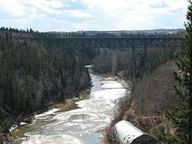
The Pembina River originates in the Canadian Rockies foothills, south of Cadomin, at Pembina Forks. It flows eastwards for 547 kilometres (340 mi) before it merges with the Athabasca River 64 kilometres (40 mi) west of the town of Athabasca, and has a drainage area of 12,900 square kilometres (5,000 sq mi).[1] Water originating in the Pembina River goes through numerous merges until reaching the Mackenzie River, discharging into the Arctic Ocean.
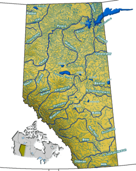
Communities located along the Pembina River include Westlock, Sangudo, Entwistle and Evansburg. Pembina River Provincial Park is along the gorges of the river between Evansburg and Entwistle. Another protected area along the river is the Pembina River Natural Area, 20 kilometres (12 mi) northeast of Cherhill in aspen parkland.[2]
Tributaries
- Rat Creek
- Bailey Creek
- Hanson Creek
- Crooked Creek
- Centre Creek
- Lovett River
- Moose Lake
- Lund Creek
- Fairfax Lake
- Errot Lake
- Dismal Creek
- Wolf Creek
- Wolf Lake
- Zeta Lake
- Rat Creek

- Paddy Creek
- Sinkhole Lake
- Bigoray River
- Mishow Creek
- Lobstick River
- Chip Lake, Deep Creek, Alpha Lake, Poison Creek, Beta Lake, Sunset Lake, Brule Creek, Little Brule Creek
- Michaud Lake
- Coyote Lake Creek
- Ice Lake
- Oldman Lake
- MacDonald Creek
- Newton Creek
- Newton Lake, George Lake, Kirchner Lake
- Paddle River
- Paddle River Reservoir, Little Paddle River
- Wabash Creek
- Fernand Lake
- Dapp Creek
- Lac des Jones, Bolloque Creek, Muskeg Lake
- Shoal Creek
- Shoal Lake, Baird Lake, Camp Creek
- Crane Lake
- Killsyth Creek
- Killsyth Lake
- Flatbrush Creek
Numerous small lakes such as Brock Lake, Oldman Lake, Majeau Lake, Lac La Nonne, George Lake, Armstrong Lake, Shoal Lake, Steele Lake, Cross Lake are also located within the river's basin.

See also
References
- ↑ Atlas of Canada - Rivers of Canada
- ↑ Alberta Community Development - Pembina River Natural Area
Coordinates: 54°44′36″N 114°17′01″W / 54.74333°N 114.28361°W