St. Paul, Alberta
| St. Paul St-Paul-de(s)-Métis (1909–1936) | |
|---|---|
| Town | |
| Town of St. Paul | |
 St. Paul | |
| Coordinates: 53°59′34″N 111°17′50″W / 53.99278°N 111.29722°WCoordinates: 53°59′34″N 111°17′50″W / 53.99278°N 111.29722°W | |
| Country |
|
| Province |
|
| Region | Northern Alberta |
| Census division | 12 |
| Municipal district | County of St. Paul No. 19 |
| Founded[1] | 1896 |
| Incorporated[2] | |
| • Village | June 14, 1912 (as St. Paul de Metis) |
| • Town | December 15, 1936 |
| Government[3] | |
| • Mayor | Glenn Andersen |
| • Governing body | St. Paul Town Council |
| Area (2011)[4] | |
| • Total | 7.89 km2 (3.05 sq mi) |
| Elevation[5] | 646 m (2,119 ft) |
| Population (2011)[4] | |
| • Total | 5,400 |
| • Density | 744.1/km2 (1,927/sq mi) |
| Time zone | MST (UTC−7) |
| • Summer (DST) | MDT (UTC−6) |
| Postal code span | T0A |
| Area code(s) | +1-780, +1-587 |
| Highways |
Highway 29 Highway 881 |
| Website | Official website |
St. Paul, originally known as St-Paul-de-Métis or St-Paul-des-Métis, is a town in east-central Alberta, Canada, within the County of St. Paul No. 19. It was known as St. Paul de(s) Métis between 1912 and 1936.[6][7]
History
The community was originally founded as a Métis colony in 1896, but the colony later dissolved sometime between 1905 and 1909.[1] After the area was made available to other groups in 1909, primarily the French-Catholic,[1] the community incorporated as the Village of St. Paul de Métis on June 14, 1912,[6] though it was referred to as St. Paul des Métis by June 6, 1922.[7] It then incorporated as the Town of St. Paul on December 15, 1936.[6]
Demographics
The population of the Town of St. Paul according to its 2014 municipal census is 6,004,[8] a 2.7% change from its 2012 municipal census population of 5,844.[9]
In the 2011 Census, the Town of St. Paul had a population of 5,400 living in 2,169 of its 2,338 total dwellings, a 5.8% change from its 2006 population of 5,106. With a land area of 7.89 km2 (3.05 sq mi), it had a population density of 684.4/km2 (1,772.6/sq mi) in 2011.[4] In 2012, Statistics Canada adjusted St. Paul's 2011 population by an additional 5 people to 5,405 to reflect its 2011 annexation.[10]
In 2006, St. Paul had a population of 5,106 living in 2,011 dwellings, a 0.9% increase from 2001. The town has a land area of 6.86 km2 (2.65 sq mi) and a population density of 744.1/km2 (1,927/sq mi).[11]
Economy
St. Paul's economy is driven by the agriculture and service industries. St. Paul is located in Alberta's Lakeland tourism district.[12]
Attractions
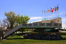
St. Paul is home to the world's first UFO landing pad,[13] built as a centennial project in an effort to attract both tourists and Martians to the municipality. The pad consists of a raised platform with a map of Canada embossed on the back stop, consisting of stones provided by each province of Canada.
On June 3, 1967, Paul Hellyer, Minister of National Defence, flew in by helicopter to officially open the Pad.[14] The pad was one of over 100 Centennial Projects organized by the town.
The sign beside the pad reads: "The area under the World's First UFO Landing Pad was designated international by the Town of St. Paul as a symbol of our faith that mankind will maintain the outer universe free from national wars and strife. That future travel in space will be safe for all intergalactic beings, all visitors from earth or otherwise are welcome to this territory and to the Town of St. Paul."
The UFO Landing pad was also featured across Canada as a film crew with Cineplex Entertainment was in the town in May 2014 filming a pre-show piece to be played in Cineplex movie theatres across Canada throughout the month of June.[15]
Notable people
- Kyle Brodziak, professional hockey player
- Wilf Martin, former professional hockey player
- Audrey Poitras, president of the Métis Nation of Alberta
- Marcel Rocque, curler
- Rena Jae, Radio Announcer and Television host
- Jamie Sadlowski, former professional power golf driver
- Bernard Trottier, politician
- Stan Smyl, former professional hockey player
- Brett Kissel, professional country singer/songwriter
See also
References
- 1 2 3 "Saint-Paul des Métis". Heritage Community Foundation. Retrieved 2012-07-15.
- ↑ "Location and History Profile: Town of St. Paul" (PDF). Alberta Municipal Affairs. October 7, 2016. p. 583. Retrieved October 11, 2016.
- ↑ "Municipal Officials Search". Alberta Municipal Affairs. December 16, 2016. Retrieved December 18, 2016.
- 1 2 3 "Population and dwelling counts, for Canada, provinces and territories, and census subdivisions (municipalities), 2011 and 2006 censuses (Alberta)". Statistics Canada. February 8, 2012. Retrieved February 8, 2012.
- ↑ "Alberta Private Sewage Systems 2009 Standard of Practice Handbook: Appendix A.3 Alberta Design Data (A.3.A. Alberta Climate Design Data by Town)" (PDF) (PDF). Safety Codes Council. January 2012. pp. 212–215 (PDF pages 226–229). Retrieved October 9, 2013.
- 1 2 3 "Location and History Profile: Town of St. Paul". Alberta Municipal Affairs. June 14, 2013. Retrieved June 17, 2013.
- 1 2 "Alteration of the Boundaries of the Village of St. Paul des Métis" (PDF). Alberta Gazette. June 15, 1922. Retrieved June 17, 2013.
- ↑ "Regular meeting of the Town of St. Paul Council" (PDF) (PDF). Town of St. Paul. August 25, 2014. p. 4. Retrieved November 23, 2014.
- ↑ "2010 Official Population List" (PDF). Alberta Municipal Affairs. September 15, 2010. Retrieved January 19, 2011.
- ↑ "Interim List of Changes to Municipal Boundaries, Status, and Names From January 2, 2011 to January 1, 2012 (Table 1 - Changes to census subdivisions in alphabetical order by province and territory)" (XLSX). Statistics Canada. November 14, 2012. Retrieved December 3, 2012.
- ↑ "St. Paul - Community Profile". Statistics Canada. Retrieved June 13, 2007.
- ↑ "Communities". Alberta's Lakeland Tourism. Retrieved 2011-03-28.
- ↑ St. Paul's UFO landing pad
- ↑ CBC News TV about St. Paul, Alberta
- ↑ http://www.spjournal.com/article/20140506/STP0801/305069967/0/STP/ufo-landing-pad-to-be-featured-across-canada
External links
 |
Vilna | Glendon | Bonnyville | |
| Andrew | |
Elk Point | ||
| ||||
| | ||||
| Two Hills | Myrnam | Dewberry |