Alberta Highway 663

Highway 663
Route information
Maintained by Alberta Transportation
Existed: 1964 – present
West segment
Length: 153 km (95 mi)
West end: Hwy 44 in Fawcett
Major
junctions:
Hwy 2
Hwy 63
East end: Hwy 55 west of Lac La Biche
East segment
Length: 40 km (20 mi)
West end: Hwy 881 east of Lac La Biche
East end: Torchwood Lake
Location
Specialized
and rural
municipalities:
Westlock County, Athabasca County, Lac La Biche County
Major cities: Boyle, Lac La Biche
Highway system

Provincial highways in Alberta

Hwy 661Hwy 665

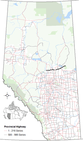
Alberta Provincial Highway No. 663[1] is a highway in the province of Alberta, Canada. It runs west-east from Highway 44 near Fawcett, runs concurrent with Highway 2 and Highway 63 to Boyle. Then to a concurrency with Highway 55 (Northern Woods and Water Route) in Lac La Biche before extending north around Lakeland Provincial Park to Torchwood Lake. It is also known as Taylor Road in Boyle, and 88 Avenue in Lac La Biche.

History

In the 1940s the roads that become Secondary Highways were only dirt trails. Farmers would have to use axes to clear the brush of the boreal forest from the road allowance, and use plows and machinery pulled by horses to maintain the roads and fill in low spots that filled with water during spring melt and summer rains. These were not all weather roads, there were no snow ploughs to keep the roads clear over the winter months, so in the 1950s the larger farm trucks could only make it through a few months of the year. By 1957, the road saw an application of gravel to the surface, and was graded. A formal surveying crew came through in 1963 to clear brush and mark the path of the highway which was constructed in 1964.[2]

Km by km description

Starting from the west end of Highway 663:

County km Intersecting road Notes Coordinates
Westlock County 0 Hwy 44, Range Road 14 Fawcett
North to Slave Lake
South to Westlock
54°33′34″N 114°6′9″W / 54.55944°N 114.10250°W / 54.55944; -114.10250 (663 km 000)
17 Hwy 801, Range Road 262 North to Cross Lake Provincial Park 54°33′29″N 113°50′11″W / 54.55806°N 113.83639°W / 54.55806; -113.83639 (663 km 017)
Athabasca County 43 Hwy 812, Range Road 241 North to Sunset Beach 54°35′14″N 113°29′3″W / 54.58722°N 113.48417°W / 54.58722; -113.48417 (663 km 043)
51 Hwy 2 South to Clyde
Begin 2 north concurrency
54°35′14″N 113°21′33″W / 54.58722°N 113.35917°W / 54.58722; -113.35917 (663 km 051)
54 Hwy 2 North to Athabasca
South to Meanook
End 2 north concurrency
54°36′1″N 113°19′33″W / 54.60028°N 113.32583°W / 54.60028; -113.32583 (663 km 054)
59 Tawatinaw River Colinton 54°37′13″N 113°15′19″W / 54.62028°N 113.25528°W / 54.62028; -113.25528 (663 km 059)
63 Hwy 827, Range Road 221 54°37′4″N 113°12′27″W / 54.61778°N 113.20750°W / 54.61778; -113.20750 (663 km 063)
83 Hwy 63, Range Road 203 South to Thorhils
Begin 63 north concurrency
54°35′13″N 112°56′30″W / 54.58694°N 112.94167°W / 54.58694; -112.94167 (663 km 083)
91 Hwy 63 Boyle
North to Fort McMurray
End 63 north concurrency
54°35′16″N 112°49′3″W / 54.58778°N 112.81750°W / 54.58778; -112.81750 (663 km 091)
92 Hwy 831, Range Road 193 South to Waskatenau 54°35′14″N 112°48′12″W / 54.58722°N 112.80333°W / 54.58722; -112.80333 (663 km 092)
97 Range Road 190 North to Mewatha Beach 54°35′15″N 112°43′39″W / 54.58750°N 112.72750°W / 54.58750; -112.72750 (663 km 097)
101 Road Bondiss 54°35′56″N 112°40′44″W / 54.59889°N 112.67889°W / 54.59889; -112.67889 (663 km 101)
113 Road Caslan 54°37′51″N 112°31′2″W / 54.63083°N 112.51722°W / 54.63083; -112.51722 (663 km 113)
Lac La Biche County 119 Hwy 855 North to Atmore
South to Smoky Lake
54°37′52″N 112°25′29″W / 54.63111°N 112.42472°W / 54.63111; -112.42472 (663 km 119)
134 Road Hylo 54°40′32″N 112°12′38″W / 54.67556°N 112.21056°W / 54.67556; -112.21056 (663 km 134)
153 Hwy 55, Northern Woods and Water Route East to Lac La Biche
West to Athabasca
54°45′44″N 112°3′14″W / 54.76222°N 112.05389°W / 54.76222; -112.05389 (663 km 153)
Hwy 663 is discontinuous for 8 km (5.0 mi)
Lac La Biche County 161 Hwy 881 West to Lac La Biche
North to Conklin
54°45′44″N 111°56′16″W / 54.762124°N 111.937678°W / 54.762124; -111.937678 (663 km 161)
164 Road Beaver Lake 54°45′43″N 111°54′6″W / 54.76194°N 111.90167°W / 54.76194; -111.90167 (663 km 164)
201 Torchwood Lake End of provincially maintained highway 54°51′37″N 111°26′1″W / 54.86028°N 111.43361°W / 54.86028; -111.43361 (663 km 201)

References

  1. Provincial Highways Designation Order, Alberta Transportation, p. 22
  2. Lac La Biche Heritage Society (2006). "Lac La Biche Yesterday and today". Our Roots. University of Calgary. p. 62. Retrieved 2009-11-05.
This article is issued from Wikipedia - version of the 10/28/2016. The text is available under the Creative Commons Attribution/Share Alike but additional terms may apply for the media files.