Alberta Highway 11
| ||||
|---|---|---|---|---|
| David Thompson Highway | ||||
 | ||||
| Route information | ||||
| Length: | 318 km (198 mi) | |||
| Major junctions | ||||
| West end: |
| |||
|
| ||||
| East end: |
| |||
| Location | ||||
| Specialized and rural municipalities: | I.D. No. 9, Clearwater County, Lacombe County, Red Deer County, Stettler No. 6 County | |||
| Major cities: | Red Deer | |||
| Towns: | Rocky Mountain House, Sylvan Lake | |||
| Highway system | ||||
|
Provincial highways in Alberta
| ||||

.svg.png)
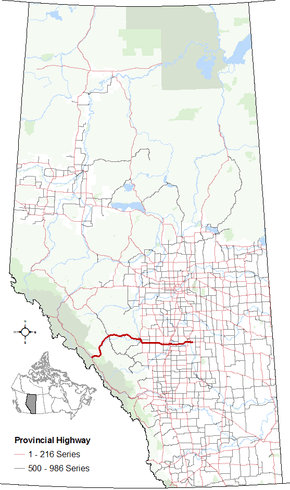
Alberta Provincial Highway No. 11 is a highway in central Alberta, Canada. It is known as the David Thompson Highway, and runs from Saskatchewan River Crossing in Banff National Park east through Nordegg, Rocky Mountain House and Red Deer until it connects with Highway 12 near Nevis. The highway is named after David Thompson, a British-Canadian fur trader, surveyor, and map-maker who explored the area between Rocky Mountain House and Kootenae House (near present-day Invermere, British Columbia) through Howse Pass.
Route description
Highway 11 begins at the Icefields Parkway (Highway 93) and travels east for 6 km (3.7 mi) through Banff National Park, where traffic is required to purchase a national parks pass.[1] The segment of Highway 11 within Banff National Park is maintained by the Government of Canada.[2]
Upon exiting Banff National Park, Highway 11 is maintained by Alberta Transportation and travels along the North Saskatchewan River, and travels through the sparsely populated Rocky Mountains Forest Reserve. The highway passes by west shore Abraham Lake and Nordegg. The highway continues east to the Town of Rocky Mountain House, where it shares a common alignment with Highway 22. The highway continues east, passing by Alhambra, Condor, Eckville, and Benalto before bypassing the Town of Sylvan Lake and enters the City of Red Deer. The highway is a four lane, divided highway between Highway 20 and Red Deer, and crosses a causeway and bridge over Cygnet Lake.[3]
Highway 11 intersects Highway 2 (Queen Elizabeth II Highway) and enters Red Deer along 67 Street and is maintained by the City of Red Deer. The highway intersects Gaetz Avenue (Highway 2A) north of Downtown Red Deer near Parkland Mall, and crosses the Red Deer River before turning south and becoming 30 Avenue. At 55 Street, Highway 11 turns east and leaves Red Deer. The length of Highway 11 within Red Deer is 10 km (6.2 mi).
Upon exiting Red Deer, Highway 11 is maintained by Alberta Transportation. The highway passes the Canyon Ski Area, crosses the Red Deer River and passes Joffre. East of Joffre, the highway follows the top of the Red Deer River valley and intersects Highway 21. Highway 11 ends at its intersection with Highway 12 near Nevis, 20 km (12 mi) west of the Town of Stettler.
Future
Red Deer area
Highway 11 has seen increased traffic west of Red Deer, resulting in multiple studies by Alberta Transportation which would improve the highway. Plans call for the highway to be upgraded to a freeway standard in which all at-grade intersections would be removed between the Queen Elizabeth II Highway (Highway 2) in Red Deer and the intersection Highway 20 at Sylvan Lake.[4] There is also a plan that calls for the permanent closure of the Highway 781 / 50 Street intersection, with Highway 781 being realigned to the Highway 20 intersection.[4][5] There is also a study on twinning Highway 11 between Sylvan Lake and Highway 766 north near Eckville.[6] Presently the improvements are unfunded.
The City of Red Deer is also constructing the North Highway Connector, also known as Northland Drive, which will serve as a northern bypass.[7][8] The connector begins at the Highway 2A / Highway 11A intersection, crosses the Red Deer River, and connects with Highway 11 in eastern Red Deer. Phase I is currently under construction connects with Highway 11 at 30 Avenue / 67 Street intersection, while a proposed Phase II would connect with 20 Avenue approximately 1.6 km (1.0 mi) further to the east.[9]
Alberta Transportation also has a right of way to realign Highway 11 east of Red Deer, bypassing its present 55 Street alignment; documentation refers to this alignment as Highway 11X.[10]
Howse Pass
There have also been proposals to extend Highway 11 west of Highway 93 across Howse Pass and connect with British Columbia Highway 1 northwest of Golden, British Columbia, known as the Howse Pass Highway.[11] Proponents of the highway argue that it would provide an alternate route to British Columba and would relieve congestion along the Trans-Canada Highway and the Yellowhead Highway. They also argue that it would reduce the distance between Central Alberta and Vancouver by 95 km (59 mi), reduce the distance travelled through Banff National Park, and open up Central Alberta to more economic opportunities.[12][13]
Opponents of the highway argue that it would cause significant environmental impact in an ecologically sensitive area, especially within Banff National Park which is a protected area.[14][15] They also argue that it would be cost prohibitive constructing the British Columbia section of the highway along the Blaeberry River, especially since the Trans-Canada Highway and the Yellowhead Highway are requiring significant upgrades, and it is a low priority in British Columbia.[16] Howse Pass is also designated as a National Historic Site which further protects the area from development and as a result it is unlikely that the highway will be constructed.
Major intersections
From west to east:[17]
| Rural/specialized municipality | Location | km[18] | mi | Destinations | Notes |
|---|---|---|---|---|---|
| I.D. No. 9 (Banff National Park) | Saskatchewan River Crossing | 0 | 0.0 | Hwy 11 begins. National park pass required on Hwy 11 within Banff National Park. | |
| Clearwater County | | 6 | 3.7 | East gate of Banff National Park | Leaves Banff National Park |
| | 42 | 26 | Crosses Cline River | ||
| Cline River | 44 | 27 | service road | ||
| | 70 | 43 | Crosses Bighorn River | ||
| | 88 | 55 | |||
| Nordegg | 90 | 56 | Stewart Street | Nordegg access road. | |
| | 113 | 70 | Saunders Alexo Road | Access to the ghost towns of Alexo and Saunders. | |
| | 144 | 89 | Sunchild Road | Access to Sunchild First Nation and O'Chiese First Nation. | |
| | 169 | 105 | |||
| | 173 | 107 | Crosses North Saskatchewan River | ||
| Rocky Mountain House | 174 | 108 | Hwy 22 concurrency begins Enters Rocky Mountain House | ||
| 178 | 111 | 52 Avenue | Access to Rocky Mountain House National Historic Site. | ||
| 179 | 111 | 42 Avenue | Leaves Rocky Mountain House | ||
| | 186 | 116 | Hwy 22 concurrency ends. | ||
| Alhambra | 199 | 124 | Range Road 54 | Alhambra access road. | |
| | 204 | 127 | North and south intersections are offset. Hwy 761 concurrency for 300 m (1000 ft). | ||
| Condor | 207 | 129 | Range Road 45 | Condor access road. | |
| Lacombe County | | 219 | 136 | Hwy 766 concurrency begins | |
| | 220 | 140 | Hwy 766 concurrency ends | ||
| ↑ / ↓ | | 173 | 107 | Crosses Medicine River | |
| Red Deer County | Benalto | 226 | 140 | Urban Approach Road 164 south | Benalto access road. |
| | 228 | 142 | Township Road 390 east – Sylvan Lake (Former Hwy 11A east) | ||
| Sylvan Lake | 237 | 147 | 60 Street north | Proposed interchange[4] | |
| 239 | 149 | ||||
| 50 Street north | Westbound entrance and exit. | ||||
| 241 | 150 | Future | Traffic signals Proposed interchange Proposed Hwy 781 realignment[4] | ||
| | 254 | 158 | Burnt Lake Trail (Former Hwy 596 south) | Traffic signals | |
| City of Red Deer | 255 | 158 | Interchange Red Deer city limits, becomes 67 Street. | ||
| 257 | 160 | Taylor Drive | |||
| 258 | 160 | ||||
| 259 | 161 | Crosses Red Deer River | |||
| 261 | 162 | 30 Avenue (Phase 1 connection to Northland Drive)[9] | Roundabout and connection to Hwy 11A under construction. Hwy 11 turns south. | ||
| 263 | 163 | 55 Street | Hwy 11 branches east. | ||
| 292 | 181 | 20 Avenue (Phase 2 connection to Northland Drive)[9] | Proposed Red Deer North Highway Connector | ||
| Red Deer County | | 274 | 170 | ||
| ↑ / ↓ | | 275 | 171 | Crosses Red Deer River | |
| Lacombe County | | 280 | 170 | ||
| | 299 | 186 | Future | Future concurrency with Hwy 921 begins. | |
| | 305 | 190 | |||
| | 311 | 193 | Future | Future concurrency with Hwy 921 ends. | |
| ↑ / ↓ | | 313 | 194 | ||
| County of Stettler No. 6 | Nevis | 318 | 198 | Hwy 11 ends. | |
| |||||
-

David Thompson Highway outside of Banff National Park
-

West terminus at Saskatchewan River Crossing
References
- ↑ Canada. "Banff National Park - Park Passes". Parks Canada. Retrieved April 26, 2016.
- ↑ "Parks Canada - Parks Canada Performance, Evaluation and Audit 2009 Plan". Parks Canada. Retrieved April 26, 2016.
- ↑ http://www.albertadiscoverguide.com/site.cfm?grid=E3&number=40
- 1 2 3 4 "Highway 11 Functional Planning Study - Executive Summary" (PDF). Government of Alberta. McElhanny Consulting Services Ltd. December 2013. Retrieved April 26, 2016.
- ↑ "Highway 20/781 Planning Study" (PDF). Government of Alberta. Dillon Consulting. May 2011. Retrieved April 26, 2016.
- ↑ "Central Provincial Highway Projects". Highway 11. Government of Alberta. July 22, 2009. Retrieved April 26, 2016.
- ↑ "North Highway Connector" (PDF). City of Red Deer. Retrieved 2016-04-26.
- ↑ "North Highway Connector". Parkland GEO. Retrieved April 26, 2016.
- 1 2 3 "North Highway Connector" (PDF). Stantec. 2014. Retrieved April 26, 2016.
- 1 2 3 "2015 Provincial Highways 1 - 216 Series Progress Chart" (PDF). Alberta Transportation. March 2015. Retrieved April 26, 2016.
- ↑ Kossowan, Brenda (July 11, 2012). "Wildrose MLA reopens Howse Pass debate". Red Deer Advocate. Retrieved April 26, 2016.
- ↑ Bekka, Khalid; Schollie, Bruce (October 12, 2005). "Economic Pre-Feasibility Study for a Howse Pass Highway". Clearwater County, Town of Rocky Mountain House, Lacombe County, Government of Alberta (PDF). Retrieved April 26, 2016.
- ↑ "Howse Pass video". Red Deer Advocate. January 15, 2016. Retrieved April 26, 2016.
- ↑ Kossowan, Brenda (July 12, 2012). "Proposal to drive highway through pass 'ridiculous'". Red Deer Advocate. Retrieved April 26, 2016.
- ↑ Douglas, Nigel (August 2012). "Howse Pass Highway: The Ridiculous National Park Highway Proposal that Refuses to Die" (PDF). Wilderness Watch. Vol. 20, No. 4. Retrieved April 26, 2016.
- ↑ Nome, Helge (June 27, 2012). "Howse Pass Highway? - Not likely". Alberta West News. Retrieved April 26, 2016.
- ↑ Alberta Road Atlas (2005 ed.). Oshawa, ON: MapArt Publishing Corp. pp. 62, 63, 64, 65, and 68.
- ↑ Google (November 14, 2016). "Highway 11 in central Alberta" (Map). Google Maps. Google. Retrieved November 14, 2016.
External links
| Wikimedia Commons has media related to Alberta Highway 11. |
- Central Provincial Highway Projects by Alberta Transportation
- The Cowboy Trail. David Thompson Highway Day Trip.
- Mile by Mile. Alberta Highway # 11