Fort Macleod
| Fort Macleod Macleod (1884–1913) | |
|---|---|
| Town | |
| Town of Fort Macleod | |
|
| |
 Fort Macleod Location of Fort Macleod in Alberta | |
| Coordinates: 49°43′32″N 113°23′51″W / 49.72556°N 113.39750°W | |
| Country |
|
| Province |
|
| Region | Southern Alberta |
| Census division | 3 |
| Municipal district | Municipal District of Willow Creek No. 26 |
| Incorporated[2] | |
| • Town | December 31, 1892 (as Macleod) |
| • Name change | April 1, 1952 |
| Government[3] | |
| • Mayor | Rene Gendre |
| • Governing body | Fort Macleod Town Council |
| • Manager | Susan Keenan |
| • MP | John Barlow (Macleod) |
| • MLA | Pat Stier (Livingstone-Macleod) |
| Area (2011)[4] | |
| • Total | 23.34 km2 (9.01 sq mi) |
| Elevation[5] | 945 m (3,100 ft) |
| Population (2011)[4] | |
| • Total | 3,117 |
| • Density | 133.5/km2 (346/sq mi) |
| Time zone | MST (UTC−7) |
| • Summer (DST) | MDT (UTC−6) |
| Postal code span | T0L |
| Area code(s) | +1-403 |
| Website | Official website |
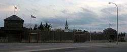


Fort Macleod, originally named Macleod, is a town in the southwest corner of the province of Alberta, Canada. It was founded as a North-West Mounted Police barracks, and is named in honour of the North-West Mounted Police Colonel James Macleod. It was known as the Town of Macleod between 1892 and 1912.[6]
History
The fort was built as a 70 by 70 meters square (233 by 233 ft) on October 18, 1874. The east side held the men's quarters and the west side held those of the Mounties. Buildings such as hospitals, stores, and guardrooms were in the south end. Stables and the blacksmith's shop were in the north end.
The town grew on the location of the Fort Macleod North-West Mounted Police (NWMP) Barracks, the second headquarters of the NWMP after Fort Livingstone was abandoned in 1876.[7] Fort Macleod was originally established in 1874 on an peninsula along the Oldman River, then moved in 1884 to the present town location.[8] The Museum of the North-West Mounted Police is located in Fort Macleod.[1]
Once agricultural settlement and the railway came to the region, Macleod boomed. The town became a CPR divisional point and frontier wood construction began to be replaced by brick and sandstone. In 1906 a fire devastated the downtown and destroyed most of the wooden buildings. From 1906 to 1912 Macleod had its greatest period of building, as more new brick and stone building replaced the destroyed wooden ones. Then in 1912 the CPR moved the divisional point and 200 jobs to Lethbridge, devastating the local economy. Fort Macleod ceased to grow, and in 1924 was forced to declare bankruptcy. Until the 1970s, the town's economy stagnated and the buildings from the turn-of-the-century remained untouched.[9]
In 1978 Alberta Culture started to inventory the downtown buildings, and in 1982 the downtown became Alberta's first "Provincial Historic Area". As well, Heritage Canada started a Main Street Restoration Project in 1982, aiming to preserve the sandstone and brick buildings, some dating back to 1878.[9][10]
UFO incident
On August 27, 1956, while an RCAF squadron leader and a Flight Lieutenant were attempting to set a speed record in an F-86 and flying over Fort Macleod, a stationary object in the sky was observed. It was brighter than the sunlight and distinctly disk-shaped. A photograph was taken of the object. Possible explanations that the object was a cloud, a sun dog, or a reflection have been ruled out because it was found to be a definite light source as it was equally bright on the side facing the sun as of its other side. Some scientists have explained the sighting as ball lightning, but others say this is unlikely due to its shape and size.[11]
Demographics
In the 2011 Census, the Town of Fort Macleod had a population of 3,117 living in 1,244 of its 1,350 total dwellings, a 1.5% change from its 2006 population of 3,072. With a land area of 23.34 km2 (9.01 sq mi), it had a population density of 133.5/km2 (345.9/sq mi) in 2011.[4]
In 2006, Fort Macleod had a population of 3,072 living in 1,278 dwellings, a 2.7% increase from 2001. The town has a land area of 23.34 km2 (9.01 sq mi) and a population density of 131.6/km2 (341/sq mi).[12]
In 2001, Fort Macleod had a population of 2,990, a 1.5% decrease from 1996.[13]
Geography
The town is located in the Municipal District of Willow Creek No. 26, at the intersection of Highway 2 and Highway 3, on the Oldman River. It lies west of the larger community of Lethbridge, near the reserves of the Peigan and Kainai First Nations. It is also located close to the Waterton Lakes National Park.
The town is located 8 kilometres (5.0 mi) north of the McBride Lake Wind Farm, one of the largest wind farms in Alberta. The wind farm has a capacity of 75 megawatts of electricity.
Climate
Fort Macleod experiences a humid continental climate (Köppen climate classification Dfb).
The community enjoys frequent breaks from cold spells in winter when the Chinook wind blows down-slope from the Rocky Mountains. A Chinook on 27 February 1992 caused the temperature to rise to 26.5 °C (80 °F).[14]
The highest temperature ever recorded at Fort Macleod was 102 °F (38.9 °C) on 7 July 1896, 18 July 1910 and 17 July 1919.[15][16][17][lower-alpha 1] The coldest temperature ever recorded was −49 °F (−45.0 °C) on 2 February 1905, 17 December 1924 and 28 January 1929.[18]
| Climate data for Fort Macleod, 1971–2000 normals, extremes 1876–present | |||||||||||||
|---|---|---|---|---|---|---|---|---|---|---|---|---|---|
| Month | Jan | Feb | Mar | Apr | May | Jun | Jul | Aug | Sep | Oct | Nov | Dec | Year |
| Record high °C (°F) | 19.8 (67.6) |
26.5 (79.7) |
27.8 (82) |
32.2 (90) |
34.5 (94.1) |
38.3 (100.9) |
38.9 (102) |
37.2 (99) |
36.7 (98.1) |
31.0 (87.8) |
26.1 (79) |
17.8 (64) |
38.9 (102) |
| Average high °C (°F) | −1.3 (29.7) |
1.9 (35.4) |
6.7 (44.1) |
12.7 (54.9) |
18.0 (64.4) |
22.4 (72.3) |
25.6 (78.1) |
24.8 (76.6) |
19.1 (66.4) |
14.3 (57.7) |
4.2 (39.6) |
−0.2 (31.6) |
12.4 (54.3) |
| Daily mean °C (°F) | −7.1 (19.2) |
−4.3 (24.3) |
0.4 (32.7) |
6.0 (42.8) |
11.1 (52) |
15.4 (59.7) |
18.0 (64.4) |
17.2 (63) |
11.8 (53.2) |
7.2 (45) |
−1.2 (29.8) |
−5.8 (21.6) |
5.7 (42.3) |
| Average low °C (°F) | −13 (9) |
−10.4 (13.3) |
−5.9 (21.4) |
−0.8 (30.6) |
4.1 (39.4) |
8.3 (46.9) |
10.4 (50.7) |
9.5 (49.1) |
4.4 (39.9) |
0.0 (32) |
−6.7 (19.9) |
−11.5 (11.3) |
−1 (30) |
| Record low °C (°F) | −45 (−49) |
−45 (−49) |
−36.7 (−34.1) |
−23.3 (−9.9) |
−15 (5) |
−10 (14) |
0.0 (32) |
−2.2 (28) |
−17.8 (0) |
−28 (−18) |
−38.9 (−38) |
−45 (−49) |
−45 (−49) |
| Average precipitation mm (inches) | 21.0 (0.827) |
17.8 (0.701) |
27.5 (1.083) |
37.7 (1.484) |
57.2 (2.252) |
61.2 (2.409) |
46.5 (1.831) |
50.0 (1.969) |
46.2 (1.819) |
18.9 (0.744) |
20.2 (0.795) |
20.9 (0.823) |
425.0 (16.732) |
| Source: Environment Canada[18][19][20] | |||||||||||||
Sports
The town is home to the Fort Macleod Mustangs hockey team of the Ranchland Hockey League.[21]
Media
Fort Macleod's local weekly newspaper is the Fort Macleod Gazette.[22]
- Historical newspapers
- Macleod Advertiser — published May 25, 1909, through September 11, 1913[23]
- Macleod Chronicle — in print approximately July 1908 through June 1909
- Macleod Gazette — early issues were entitled The Macleod Gazette and Alberta Stock Record
- Macleod News — ran from November 2, 1916, through to June 1919
- Macleod Spectator — lasted from April 30, 1912, until October 26, 1916


A selection of historical newspapers from Fort Macleod have been digitized from microfilm and are available in the Southern Alberta Newspaper Collection from the University of Lethbridge Library digitized collections. Included are: Macleod Advertiser (1908–1913), Macleod Chronicle (1908–1909), Macleod Gazette (1897–1907), Macleod News (1916–1919), & Macleod Spectator (1912–1916).
Notable people
- Henrietta Muir Edwards, women's rights activist
- Frederick Maurice Watson Harvey, Irish-Canadian soldier and rugby union athlete
- Sir Frederick Haultain, former premier of the North-West Territories
- Joni Mitchell, musician
- Constantine Scollen, missionary
Film
Ang Lee's Academy Award-winning movie Brokeback Mountain was filmed in part in Fort Macleod. The laundry apartment is located at 2422 Third Avenue, where a sign is posted marking the "passionate reunion" of Jack and Ennis. Passchendaele was also filmed in Fort Macleod's historic downtown, which acted as a stand-in for Calgary circa 1915. Scenes involving the dust storm and Matthew McConaughey's character were also filmed in Fort Macleod in Christopher Nolan's 2014 film Interstellar, where the giant dust clouds were created on location using large fans to blow cellulose-based synthetic dust through the air.[24]
See also
- Fort Macleod Airport
- List of communities in Alberta
- List of towns in Alberta
- RCAF Station Fort Macleod
References
- 1 2 3 Museum of the North-West Mounted Police
- ↑ "Location and History Profile: Town of Fort Macleod" (PDF). Alberta Municipal Affairs. October 7, 2016. p. 463. Retrieved October 13, 2016.
- ↑ "Municipal Officials Search". Alberta Municipal Affairs. November 18, 2016. Retrieved November 21, 2016.
- 1 2 3 "Population and dwelling counts, for Canada, provinces and territories, and census subdivisions (municipalities), 2011 and 2006 censuses (Alberta)". Statistics Canada. 2012-02-08. Retrieved 2012-02-08.
- ↑ "Alberta Private Sewage Systems 2009 Standard of Practice Handbook: Appendix A.3 Alberta Design Data (A.3.A. Alberta Climate Design Data by Town)" (PDF) (PDF). Safety Codes Council. January 2012. pp. 212–215 (PDF pages 226–229). Retrieved October 8, 2013.
- ↑ "Location and History Profile: Town of Fort Macleod". Alberta Municipal Affairs. June 14, 2013. Retrieved June 17, 2013.
- ↑ Historic Fort Livingstone
- ↑ Fort Macleod history
- 1 2 http://www.fortmacleod.com/visiting/attractions/Main%20Street%20History.cfm
- ↑ Alberta First. Fort Macleod Overview
- ↑ The Canadian UFO Report: The Best Cases Revealed, Chris Rutkowski and Geoff Dittman, 2006, ISBN 1-55002-621-6
- ↑ Statistics Canada (2006). "Fort Macleod - Community Profile". Retrieved 2007-06-11.
- ↑ Fort Macleod profile - Statistics Canada. 2002. 2001 Community Profiles. Released June 27, 2002. Last modified: 2005-11-30. Statistics Canada Catalogue no. 93F0053XIE
- ↑ Environment Canada—Canadian Climate Data, accessed 2 August 2016
- ↑ Environment Canada—Canadian Climate Data, accessed 2 August 2016
- ↑ Environment Canada—Canadian Climate Data, accessed 2 August 2016
- ↑ Environment Canada—Canadian Climate Data, accessed 2 August 2016
- 1 2 Environment Canada—Canadian Climate Normals 1971–2000, accessed 3 April 2010
- ↑ Environment Canada—Canadian Climate Data, accessed 2 August 2016
- ↑ Environment Canada—Canadian Climate Data, accessed 2 August 2016
- ↑ "RHL – About Us". Ranchland Hockey League. Retrieved 2011-03-09.
- ↑ Fort Macleod Gazette
- ↑ Strathern, Gloria M. (1988). Alberta Newspapers, 1880-1982: An Historical Directory. University of Alberta. ISBN 0-88864-137-0.
- ↑ Frank McTighe (August 28, 2013). "Hollywood star Matthew McConaughey in Fort Macleod to film scene from 'Interstellar'"". Macleod Gazette. Retrieved January 9, 2015.
- Famous Five Foundation biography of Henrietta Muir Edwards
- http://www.usask.ca/history/buffalo/About%20Buffalo.htm
- ↑ A temperature of 109 °F (42.8 °C) was recorded on 21 July 1877, but this value appears to be incorrect given the elevation of Fort Macleod and the irregularity of observations in that year.
External links
| Wikimedia Commons has media related to Category:Fort Macleod. |
 |
Claresholm | Granum | Nobleford | |
| Cowley | |
Coalhurst | ||
| ||||
| | ||||
| Pincher Creek | Glenwood | Magrath |
Coordinates: 49°43′32.1″N 113°23′51.1″W / 49.725583°N 113.397528°W