Warner, Alberta
| Warner | |
|---|---|
| Village | |
| Village of Warner | |
| Nickname(s): Home of the First Last Elevator Row In Alberta | |
 Warner Location of Warner | |
| Coordinates: 49°16′00″N 112°12′00″W / 49.26667°N 112.20000°W | |
| Country |
|
| Province |
|
| Region | Southern Alberta |
| Census Division | No. 2 |
| Municipal district | County of Warner No. 5 |
| Incorporated[1] | |
| • Village | November 12, 1908 |
| Government[2] | |
| • Mayor | Tyler Lindsay |
| • Governing body | Warner Village Council |
| Area (2011)[3] | |
| • Total | 1.15 km2 (0.44 sq mi) |
| Elevation[4] | 1,021 m (3,350 ft) |
| Population (2011)[3] | |
| • Total | 331 |
| • Density | 288.5/km2 (747/sq mi) |
| Time zone | MST (UTC-7) |
| Highways | 4, 36, 505 |
| Website | Official website |
Warner is a village in southern Alberta, Canada. It is located in the County of Warner No. 5, approximately 65 km south of the city of Lethbridge. Warner is a farming community. Warner is situated at the intersection of Highway 4 and Highway 36, about 38 km north of the Montana border and Interstate 15. Warner's nearest neighbours are the towns of Stirling and Milk River.
The village is home to the Warner Hockey School,[5] one of the premier girls' hockey schools in Canada. It is also home to the Devil's Coulee Dinosaur Heritage Museum.[6]
Demographics
In the 2011 Census, the Village of Warner had a population of 331 living in 161 of its 190 total dwellings, a 7.8% change from its 2006 population of 307. With a land area of 1.15 km2 (0.44 sq mi), it had a population density of 287.8/km2 (745.5/sq mi) in 2011.[3]
The population of the Village of Warner according to its 2011 municipal census is 392,[7] a 2.3% increase from its 2007 municipal census population of 383.[8]
In 2006, Warner had a population of 307 living in 171 dwellings, a 19.0% decrease from 2001. The village has a land area of 1.15 km2 (0.44 sq mi) and a population density of 267.6/km2 (693/sq mi).[9]
Local attractions
- Devil's Coulee Dinosaur Heritage Museum
The Devil's Coulee Dinosaur Heritage Museum[10] features a Hadrosaur (duck-billed dinosaur) nest and embryo, ancient fossils, dinosaur models, located in the Warner.
- Warner elevator row
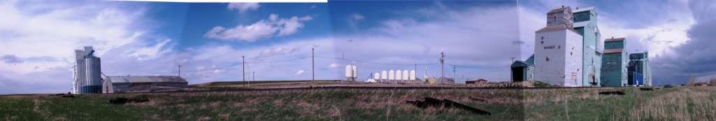
The Warner elevator row is a row of historic wood-cribbed grain elevators. A total of six elevators still stand in a row from south to north alongside the Canadian Pacific Railway on the east entrance of the village of Warner. Due to the loss of a vast amount of Alberta's many grain elevators, the elevator row in Warner remains the very last row of elevators in Alberta. Only one elevator row remains in Canada, the elevators in Inglis, Manitoba.
Regional attractions
- Galt Historic Railway Park
The Galt Historic Railway Park located 1 km north of Stirling is another popular museum which displays of life and travel in the 1880s to 1920s are set up in the restored 1890 North West Territories International Train Station from Coutts, Alberta, Canada and Sweetgrass, Montana, USA. The station was moved to the current location near Stirling in 2000 and is added onto every year. Future plans to move the 1925 Oglvie grain elevator from Wrentham for display along the station in the 36-acre (150,000 m2) park is still in the planning stages.
- Stirling Agricultural Village
Stirling Agricultural Village is a National Historic Site of Canada, and was listed as one of only three communities in Canada designated as a National Historic Site because of the community’s well preserved settlement pattern that follows the Plat of Zion model.[11] Located within the village are two museums the Michelsen Farmstead a totally restored 1900s home showcasing rual life in Alberta in the 1930s. Listed as a Provincial Historic Site in 2001.,[12] and the Galt Historic Railway Park.
- Waterton Lakes National Park
Waterton Lakes National Park is a National Park located in the extreme southwest corner of Alberta, Canada, 40 km west of Cardston, and borders Glacier National Park in Montana, USA. Waterton Lakes was Canada's fourth National Park formed in 1895. The Rocky Mountains rise suddenly out of the rolling prairies in the park. Amid the peaks are the three Waterton Lakes, carved out of the rock by ancient glaciers.
- Writing On Stone Provincial Park
Writing-on-Stone Provincial Park, is one of the largest areas of protected prairie in the Alberta park system, and serves as both a nature preserve and protection for the largest concentration of rock art, created by Plains People. There are over 50 rock art sites, with thousands of figures, as well as numerous archeological sites.
See also
References
- ↑ "Location and History Profile: Village of Warner" (PDF). Alberta Municipal Affairs. October 21, 2016. p. 604. Retrieved October 23, 2016.
- ↑ "Municipal Officials Search". Alberta Municipal Affairs. December 16, 2016. Retrieved December 18, 2016.
- 1 2 3 "Population and dwelling counts, for Canada, provinces and territories, and census subdivisions (municipalities), 2011 and 2006 censuses (Alberta)". Statistics Canada. 2012-02-08. Retrieved 2012-02-08.
- ↑ "Alberta Private Sewage Systems 2009 Standard of Practice Handbook: Appendix A.3 Alberta Design Data (A.3.A. Alberta Climate Design Data by Town)" (PDF) (PDF). Safety Codes Council. January 2012. pp. 212–215 (PDF pages 226–229). Retrieved October 9, 2013.
- ↑ Warner Hockey School
- ↑ Devil's Coulee Dinosaur Heritage Museum
- ↑ "2011 Municipal Affairs Population List" (PDF). Alberta Municipal Affairs. 2010-10-05. Retrieved 2011-12-12.
- ↑ "2010 Official Population List" (PDF). Alberta Municipal Affairs. 2010-09-15. Retrieved 2011-12-12.
- ↑ Statistics Canada. "Canada 2006 Census: Warner - Community Profile". Retrieved 2007-06-09.
- ↑ Village of Warner. "Devil's Coulee Dinosaur Heritage Museum". Archived from the original on 2007-07-29. Retrieved 2007-08-02.
- ↑ Parks Canada (June 2007). "Village of Stirling National Historic Site". Retrieved 2007-11-13.
- ↑ Village of Stirling. "Michelsen Farmstead". Retrieved 2007-11-13.
External links
 |
Stirling New Dayton |
Wrentham | Skiff | |
| Spring Coulee Magrath |
|
Manyberries | ||
| ||||
| | ||||
| Del Bonita | Milk River |
Coordinates: 49°16′5″N 112°12′9″W / 49.26806°N 112.20250°W