Stirling, Alberta
| Stirling | |||
|---|---|---|---|
| Village | |||
| Village of Stirling | |||
|
Galt Historic Railway Park north of Stirling. | |||
| |||
|
Nickname(s): The Junction Town (1912)[1] Village of Gardens[2] A Town of Two Towns | |||
| Motto: Experience The History | |||
 Stirling Location of Stirling in Alberta | |||
| Coordinates: 49°30′08″N 112°31′00″W / 49.50222°N 112.51667°W | |||
| Country |
| ||
| Province |
| ||
| Region | Southern Alberta | ||
| Census division | 2 | ||
| Municipal district | County of Warner No. 5 | ||
| Founded | 1899 | ||
| Incorporated[3] | |||
| • Village | September 3, 1901 | ||
| Government[4] | |||
| • Mayor | Ben Nilsson | ||
| • Governing body | Stirling Village Council | ||
| • CAO | Michael Selk | ||
| • MP | Jim Hillyer | ||
| • MLA | Gary Bikman | ||
| Area (2011)[5] | |||
| • Total | 2.64 km2 (1.02 sq mi) | ||
| Elevation | 935 m (3,068 ft) | ||
| Population (2011)[5] | |||
| • Total | 1,090 | ||
| • Density | 413.6/km2 (1,071/sq mi) | ||
| Time zone | MST (UTC-7) | ||
| Postal code span | TOK 2EO | ||
| Area code(s) | +1-403 | ||
| Highways |
Highway 4 Highway 61 Highway 846 | ||
| Waterways |
Etzikom Coulee Kipp Coulee Stirling Lake Milk River Ridge Reservoir | ||
| Historic Sites |
Galt Historic Railway Park Michelsen Farmstead William T. Ogden House | ||
| Website | Official website | ||


Stirling is a village in the County of Warner No. 5, Alberta, Canada. The village is located on Highway 4, approximately 31 km (19 mi) southeast of Lethbridge and 72 km (45 mi) northwest of the Canada–US border.
The Village of Stirling is also referred to as Stirling Agricultural Village due to its designation as a National Historic Site of Canada. It is one of only three Canadian communities designated as such, Quebec City and Louisbourg, Nova Scotia being the other two.
History

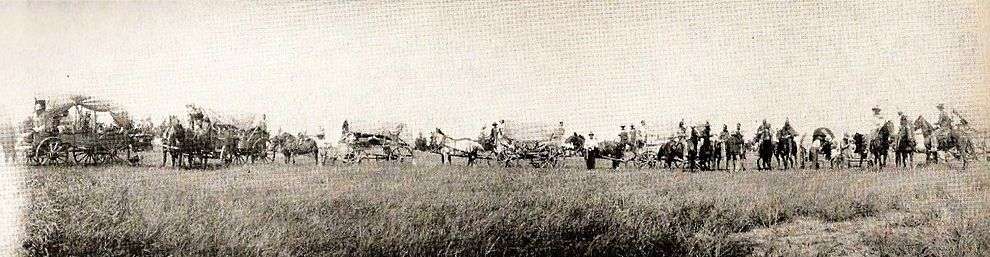
As railway developed in Southern Alberta throughout the 1880s, the Canadian Pacific Railway (CPR) built a line from Calgary to Fort Macleod, and the Alberta Railway and Coal Company (ARCC) constructed a narrow gauge line from Lethbridge to Medicine Hat to supply coal to the CPR.[6] In 1899, the ARCC built another narrow gauge line from Lethbridge to Great Falls, Montana through the Coutts-Sweetgrass border crossing, closely following the route of the old Whoop-up Trail.[7]
The line was not built to promote colonization, but to open additional markets for Lethbridge coal in Montana. There was a limited amount of ranching along the route and no agricultural settlement. The ARCC opened the line to advertise land in parcels of 80-6401 acres for stock. The first station along the line south of Lethbridge was located near what was than known as "18 Mile Lake" (18 miles from Lethbridge),[8] so the trains would have water for the engines. This station was named after J. A. Stirling, an executive in a company in England that helped finance the ARCC. At that time, there were no people or buildings in the region, with the exception of station employees who lived in the section house.
With the arrival of irrigation on November 14, 1899,[9] the Village of Stirling developed adjacent to the ARCC and station house.
On May 5, 1899, a small band of 30 Mormon settlers led by Theodore Brandley of Richfield, Utah, arrived at Stirling station. Theodore Brandley, with the help of Charles Ora Card, began planning the layout of the new town. The town site was to be made up of one square mile (640 acres), then divided into lots of 10 acres (40,000 m2); each with a surveyed road around the entire area with a lane running north and south, dividing it into two parcels. The parcels were again divided, east and west, making four lots, each 2.5 acres (10,000 m2), giving the residents room to build homes, barns and shelters for animals, with large gardens. Theodore planned the town site after the Plat of Zion,[10] which Stirling still follows today, and is recognized as the most well-preserved, Canadian example of the Plat of Zion. For this reason, Stirling is known as Stirling Agricultural Village.[11]
Stirling is one of only two communities that owed its existence to a partnership between The Church of Jesus Christ of Latter-day Saints and Charles A. Magrath of the North Western Coal and Navigation Company,[12] and it is one of only three communities designated as a National Historic Site of Canada.[13]
New Stirling
Construction of the St. Mary Railway, beginning in Stirling and ending in Cardston began in 1900 and was finished in 1902. The Canadian Pacific Railway took over all assets of Alberta Railway and Irrigation company (successor of Alberta Railway Coal Company) in 1912[14] and started construction of a new line east of Stirling to Saskatchewan. Stirling had now become an important railway junction in Southern Alberta with rail lines from north, south, east and west.
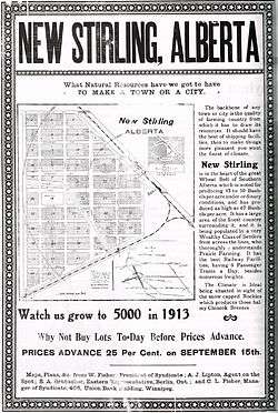
To accommodate the expansion of the railway the CPR needed more space for yards and shunting. Kipp Coulee near the original station did not have enough room to expand, so the CPR moved the station one mile north. This created an ideal location for a new town. A townsite was planned and lots were advertised for sale in what was called New Stirling also known as New Town.[15] Due to confusion between the two post offices in Stirling and New Stirling, the name was changed to Maybutt. Mr. Fisher, who was the original owner and planner of the townsite, decided to rename the town after his wife, Mrs. "May Butt".[16]
A large hotel; the Prairie Queen Hotel, a Presbyterian Church, and more a variety of other businesses and houses quickly sprung up shortly after land was opened up. The community even had its own newspaper; the "New Stirling Star". The town did not flourish, and eventually buildings were moved away, the school was closed and in the 1950s the post office closed its doors.
Maybutt has slowly died off making it a ghost town with few original buildings remaining.[17] In recent years homes have been moved into Maybutt as small hobby farms and acreages.
Geography and climate
Stirling is in the County of Warner No. 5, and lies 31 km (19 mi) south-east of Lethbridge, at the junction of Highway 4 and Highway 846. The Milk River Ridge is south of the village, and Etzikom Coulee and Kipp Coulee are north of it.
| Coordinates: | 49°30′N 112°31′W / 49.500°N 112.517°W |
|---|---|
| Elevation | 935 metres (3,068 ft) |
| Land Area | 2.64 square kilometres (1.02 sq mi) |
Climate
Stirling experiences a semi-arid climate (Köppen climate classification BSk). Stirling is subject to chinooks, which bring temperatures in mid-winter above 10 °C (50 °F). Chinooks bring more than 200 days of wind a year.[18]
| Climate data for Stirling | |||||||||||||
|---|---|---|---|---|---|---|---|---|---|---|---|---|---|
| Month | Jan | Feb | Mar | Apr | May | Jun | Jul | Aug | Sep | Oct | Nov | Dec | Year |
| Record high °C (°F) | 16.7 (62.1) |
21.8 (71.2) |
23.3 (73.9) |
31.1 (88) |
34.2 (93.6) |
38.3 (100.9) |
39.4 (102.9) |
38.9 (102) |
36.7 (98.1) |
31.7 (89.1) |
22.8 (73) |
19.6 (67.3) |
39.4 (102.9) |
| Average high °C (°F) | −1.8 (28.8) |
1.5 (34.7) |
6 (43) |
12.9 (55.2) |
18.2 (64.8) |
22.3 (72.1) |
25.5 (77.9) |
25.4 (77.7) |
20.1 (68.2) |
14 (57) |
4.3 (39.7) |
−0.2 (31.6) |
12.3 (54.1) |
| Daily mean °C (°F) | −7.8 (18) |
−4.6 (23.7) |
−0.2 (31.6) |
6.0 (42.8) |
11.3 (52.3) |
15.5 (59.9) |
18.0 (64.4) |
17.7 (63.9) |
12.6 (54.7) |
7.0 (44.6) |
−2.5 (27.5) |
−6.1 (21) |
5.7 (42.3) |
| Average low °C (°F) | −13.8 (7.2) |
−10.7 (12.7) |
−6.5 (20.3) |
−0.9 (30.4) |
4.2 (39.6) |
8.6 (47.5) |
10.5 (50.9) |
10 (50) |
5.1 (41.2) |
0 (32) |
−7.2 (19) |
−12 (10) |
−1.1 (30) |
| Record low °C (°F) | −42.8 (−45) |
−42.2 (−44) |
−38 (−36) |
−25.6 (−14.1) |
−11.7 (10.9) |
−1.7 (28.9) |
0.9 (33.6) |
−1 (30) |
−9.4 (15.1) |
−26.7 (−16.1) |
−34.7 (−30.5) |
−42.8 (−45) |
−42.8 (−45) |
| Average precipitation mm (inches) | 17.6 (0.693) |
11.6 (0.457) |
24 (0.94) |
31.3 (1.232) |
53.5 (2.106) |
63 (2.48) |
47.5 (1.87) |
45.8 (1.803) |
36.9 (1.453) |
18.9 (0.744) |
16.9 (0.665) |
16.7 (0.657) |
386.3 (15.209) |
| Source: Environment Canada[19] | |||||||||||||
Economy

Agriculture
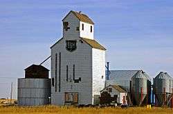
Historically, Stirling's economy has relied mainly on agriculture as a main industry. The community still has strong roots to agriculture and has become one of the 21 communities that have joined the South Grow Regional Initiative,[20] a proposal to accelerate and enhance economic development and sustainability for communities within the SouthGrow Regional Initiative region. Three quarters of a mile north east of town stands a 200 foot tall concrete terminal grain elevator. The large elevator was built between 1998-1999 at a cost of $11 million and was one of the first elevators of its kind in the area. The elevator was built with a capacity of 17,500 metric tonnes.
Other industries
Stirling's location and rich history makes tourism another main industry. Stirling has a variety of businesses[21] and recreation, such as a convenience store, a wooden crib grain elevator now used as a hemp plant, a truck and tractor dealer, a pool, a community-owned campground, and a library, two museums and a community park known as Centennial Park.
Demographics
The Village of Stirling's 2013 municipal census counted a population of 1,147,[22] a −0.9% change from its 2010 municipal census population of 1,157.[23]
In the 2011 Census, the Village of Stirling had a population of 1,090 living in 327 of its 352 total dwellings, an 18.3% change from its 2006 population of 921. With a land area of 2.64 km2 (1.02 sq mi), it had a population density of 412.9/km2 (1,069.4/sq mi) in 2011.[5] At its current population, Stirling is the largest village in the province and is eligible for town status. According to Alberta's Municipal Government Act, a village is eligible for town status when it reaches 1,000 residents.[24]
In the 2006 Census, Stirling had a population of 921 living in 299 dwellings, a 5.0% increase from 2001. The village has a land area of 2.64 km2 (1.02 sq mi) and a population density of 349.5/km2 (905/sq mi).[25]
According to the 2001 Canadian census,[26] of those respondents who indicated religious affiliation, all but 13% considered themselves Christian.
- Protestant: 78% (mostly LDS)
- Catholic: 9%
- No religious affiliation: 13%
- Christian Orthodox: 0%
- Christian (unspecified denomination): 0%
Government
The village is governed by a village council composed of a mayor and four councillors, and administered by a village chief administrative officer.[4] Municipal elections are held every four years.
Infrastructure
The village is connected to two highways: Highway 4, which heads south to Interstate 15 and north to Lethbridge, and the historic Red Coat Trail[27] also known as Highway 61, which heads east to Foremost and then ends in Manyberries.
Emergency services are provided by the Raymond and District Hospital and police station located in Raymond, while the village has its own volunteer fire department, which has served Stirling and area since 1957.[28]
Tourism
Stirling's recreational facilities[29] include ball parks, a swimming pool, a tennis court, a community centre, a picnic area, playgrounds, rodeo grounds, fish pond, and library.[30] The Milk River Ridge Reservoir[31] south of Stirling supports water recreation in the summer months, and Stirling Lake also known as Michelsen Marsh, north of Stirling supports bird watchers year-round.
On east entrance of Main Street is a newly built information kiosk made to replicate that of an older pioneer home found throughout Stirling and area. In the kiosk are historical markers and a map that shows many sites of interest throughout the National Historic Site of Stirling.
Museums

- Michelsen Farmstead[32] - a typical farmstead found throughout Stirling in the early 1900s. The Michelsen's farmstead was declared a Provincial Historic Site of Alberta in 2001, and is maintained by the Stirling Historical Society who have restored the farm back to its 1930s heritage. Located on the corner of 6th Street and 2nd Avenue.
- Bishop's storehouse, Also known as Lord's storehouse, moved to its current location next to the Kiosk on the corner of 1st Street and 4th Avenue.
Local attractions
- Stirling Lions Club Fish Pond, stocked every year with new fish for fishing. Corner of 7th Street and 4th Avenue.
- Centennial Park, community park with swimming pool,play grounds, a tennis court, basketball courts, reunion center, a senior citizen's center, baseball diamonds and a campground.
- Prairie Cactus Mini Putts, a privately owned miniature golf course, open by request. Corner of 1st Street and 7th Avenue.
- William T. Ogden House, a Neo-Classical style house that is declared as a Provincial historic site of Alberta located in Stirling. Every year around Halloween the owners of the home decorate the 7,000 sq ft (650 m2) house as a live haunted house, making it the largest haunted house in southern Alberta. 441 4th Street.[33]
- Lost Frontier Mini-Railway,[34] a small train park open by booking from May to October and is a very popular local attraction. Located on the grounds of the William T. Ogden Home, the park also has a petting zoo, a mini village, a large Cuckoo clock as well as the "worlds smallest church". 441 4th Street.
Events
- Stirling Community Garage Sale (Saturday of May-long), community garage sale held by the Stirling Historical Society.
- Lions Community BBQ (June), community BBQ held at the Stirling Lions Hall.
- Stirling Settler Days (July), after Stirling's founding on May 5, 1899, the 24th of July, previously known as "Pioneer Day" & now called "Stirling Settler Days", was celebrated to mark the Mormon pioneers' arrival in the Salt Lake Valley.
- Stirling Fall Festival (September), held at the grounds of the Michelsen Farmstead each year. Visitors get to make rope, stick dolls, and dipped candles, there are also wagon rides as well as kiddie games.
- Harvest Dance (October), also held at the Michelsens farmstead, Old-fashioned Barn dance.
- Stirling Haunted Mansion (October), located in the William Ogden House, also known as the largest haunted house in Southern Alberta.
- Lions Christmas Dinner (November), a community dinner with traditional home cooking.
- Santa Claus Mansion (December), held at the William Ogden House in conjunction with the town's Christmas lights tour.
- Christmas Lights tour (December), held in conjunction with the Santa Claus Mansion to view citizen's Christmas light displays.
Regional attractions
- Devil's Coulee Dinosaur Heritage Museum
The Devil's Coulee Dinosaur Heritage Museum[35] features a Hadrosaur (duck-billed dinosaur) nest and embryo, ancient fossils, dinosaur models, located in the Village of Warner.
- Galt Historic Railway Park
The Galt Historic Railway Park located 1 km north of Stirling is another popular museum which displays the life and travel of the late 1880s to early 1920s in the restored 1890 North-West Territories International Train Station from Coutts, Alberta, Canada, and Sweetgrass, Montana, USA. The station was moved to the current location near Stirling in 2000 and is added onto every year. Future plans to move the 1925 Oglvie grain elevator from Wrentham for display along the station in the 36-acre (150,000 m2) park is still in the planning stages.
- Waterton Lakes National Park
Waterton Lakes National Park is a national park located in the extreme southwest corner of Alberta, Canada, 40 km west of Cardston, and borders Glacier National Park in Montana, USA. Waterton Lakes was Canada's fourth national park formed in 1895. The Rocky Mountains rise suddenly out of the rolling prairies in the park. Amid the peaks are the three Waterton Lakes, carved out of the rock by ancient glaciers.
- Writing-on-Stone Provincial Park
Writing-on-Stone Provincial Park, 44 km east of Milk River, is one of the largest areas of protected prairie in the Alberta park system, and serves as both a nature preserve and protection for the largest concentration of rock art, created by Plains People. There are over 50 rock art sites, with thousands of figures, as well as numerous archeological sites.
Education

Stirling has one school that covers Kindergarten through grade 12 in the Westwind School Division. Enrollment for Stirling School[36] was 322 in 2006.
Stirling School is home to a few athletic teams, from volleyball to badminton, even golf.
Sports
The high school girls basketball team, the Lakettes, won the 1A girls basketball provincial championships in 1997–1999. They placed in three other provincial championships between 1996 and 2006, and won or placed second for 6 straight years between 1996–2003.
The high school boys basketball team, the Lakers, won the 1A boys basketball provincial championships in 2001, 2003, 2006, 2007 and 2008. They placed second in three other provincial championships between 1996 and 2006, and have played in 6 of the last 10 championships.[37]
In 2006 the final game was a decisive 98-68 victory over the third-ranked Youngstown Falcons. Besides the provincial title, the Stirling Lakers recorded a season of 30 wins, 9 losses, and 3 other tournament champion titles, including the 1A South Zone Title, the Picture Butte Sugar King Invitational, and the Mccoy Invitational.
The Stirling Lakers followed up their 2006 season with another provincial title in 2007. The Lakers were victorious in the championship game over their rivals from Foremost. On their way to provincials, the Lakers were also crowned South Zone champions.
In 2008 Stirling hosted provincials and ended up winning their third provincial title in a row.
Media
Stirling is served by a number of regional newspapers including the Westwind Weekly, Lethbridge Herald, and Prairie Post. At one time, Stirling had a newspaper of its own called the Stirling Star.[38]
Newspapers
- Lethbridge Herald
- Prairie Post, a newspaper focused on Alberta and the southwest region of Saskatchewan.
- Stirling Star was Stirling's newspaper printed in New Stirling until the late 1930s.
- Westwind Weekly, a weekly newspaper featuring news from Stirling and surrounding communities.
Movies
- Pure Escape, movie shot throughout southern Alberta and Stirling in the 1980s.
- The Calgary Stampede, movie filmed in 1925, starring Hoot Gibson. Gibson rode a team of palomino horses in a Roman standing race filmed at the Calgary Stampede. The palomino horses were from the Bascom Ranch of Stirling.
- RV, movie filmed in the Vancouver area and southern Alberta including the Stirling area, May–December 2005, starring Robin Williams, Cheryl Hines, Joanna Levesque, Josh Hutcherson, Jeff Daniels, and Kristin Chenoweth.
Notable people
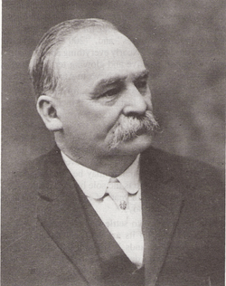
- Theodore Brandley, LDS missionary and colonizer of Stirling[39]
- Reg Kesler, Calgary Stampede champion and member of the Canadian Professional Rodeo Hall of Fame[40]
See also
- List of attractions and landmarks in Stirling, Alberta
- List of communities in Alberta
- List of national historic sites of Canada
- List of provincial historic sites of Alberta
- List of villages in Alberta
- Scottish place names in Canada
References
- ↑ Stirling the Junction Town Lethbridge Herald Archives Retrieved on September 28, 2008.
- ↑ Village of Gardens Lethbridge Herald Archives Retrieved on January 15, 2009.
- ↑ "Location and History Profile: Village of Stirling" (PDF). Alberta Municipal Affairs. October 21, 2016. p. 562. Retrieved October 23, 2016.
- 1 2 "Municipal Officials Search". Alberta Municipal Affairs. December 16, 2016. Retrieved December 18, 2016.
- 1 2 3 "Population and dwelling counts, for Canada, provinces and territories, and census subdivisions (municipalities), 2011 and 2006 censuses (Alberta)". Statistics Canada. February 8, 2012. Retrieved February 8, 2012.
- ↑ The Galt Enterprises
- ↑ The Beginning: Narrow Gauge to Lethbridge
- ↑ Book: The Mormon Cultural Landscape at Stirling Agricultural Village, Alberta By Robert M. Graham
- ↑ Hicken, John R (1968). Events Leading to the Settlement of the Communities of Cardston, Magrath, Stirling and Raymond, Alberta. Logon, Utah: Utah State University. p. 78.
- ↑ Plat Zion of the city of Zion, by Joseph Smith. Retrieved on August 2, 2007
- ↑ Parks Canada Village of Stirling National Historic Site of Canada, Parks Canada, accessed 2008-02-26.
- ↑ North Western Coal and Navigation Company Retrieved on August 2, 2007
- ↑ Parks Canada - Stirling Agricultural Village
- ↑ Canadian Pacific Railway History of the Railway. Retrieved on July 5, 2008.
- ↑ Alberta Place Names - Maybutt, Alberta
- ↑ Canadian Heritage Parks Canada - Book: A Cultural Landscape History of Stirling, Alberta - By Elise A. Corbet
- ↑ New Stirling Picture Gallery Ghost towns of Canada Retrieved on July 5, 2008.
- ↑ Weather Environment Canada. Retrieved on August 26, 2008.
- ↑ Environment Canada—Canadian Climate Normals 1971–2000, accessed March 23, 2010
- ↑ South Grow Regional Initiative "Stirling - Community Profile" Retrieved on January 4, 2008
- ↑ Stirling Business Directory. Retrieved on August 31, 2008.
- ↑ "2013 Municipal Affairs Population List" (PDF) (PDF). Alberta Municipal Affairs. November 20, 2013. ISBN 978-1-4601-1418-6. Retrieved December 5, 2013.
- ↑ "2011 Municipal Affairs Population List" (PDF) (PDF). Alberta Municipal Affairs. October 5, 2011. ISBN 978-0-7785-9738-4. Retrieved December 5, 2013.
- ↑ "Municipal Government Act". Alberta Queen's Printer. Retrieved September 5, 2012.
- ↑ "Canada 2006 Census: Stirling - Community Profile". Statistics Canada. Retrieved June 9, 2007.
- ↑ "Canada 2001 Census: Stirling - Community Profile". Statistics Canada. Retrieved October 30, 2007.
- ↑ "Red Coat Trail". The Canadian Encyclopedia. Retrieved August 5, 2008.
- ↑ "Stirling Emergency Services". Stirling Fire Department. Archived from the original on July 24, 2009. Retrieved August 5, 2008.
- ↑ "Stirling's recreational facilities". Village of Stirling. Retrieved August 2, 2007.
- ↑ "Theodore Brandley Library". Chinook Arch Regional Library System. Retrieved August 2, 2007.
- ↑ "Milk River Ridge Reservoir". County of Warner No. 5. Retrieved August 2, 2007.
- ↑ Michelsen Farm http://waltonfeed.com/stirling/history/vtour/mfarm.html
- ↑ William T. Ogden House Stirling Haunted Mansion. Retrieved on August 2, 2007
- ↑ William T. Ogden House Lost Frontier Mini-Railway. Retrieved on August 2, 2007
- ↑ "Devil's Coulee Dinosaur Heritage Museum". Village of Warner. Archived from the original on July 29, 2007. Retrieved August 2, 2007.
- ↑ Stirling School. Retrieved on August 2, 2007
- ↑ Alberta Schools' Athletic Association website Retrieved on March 1, 2006.
- ↑ New Stirling Star. Retrieved on August 2, 2007
- ↑ "Biography of Theodore Brandley". Stirling Historical Society. Retrieved August 2, 2007.
- ↑ Canadian Pro-Rodeo Hall of Fame Biography of Reg Kesler Retrieved on August 2, 2007
External links
| Wikimedia Commons has media related to Stirling, Alberta. |
 |
Lethbridge | Coaldale Maybutt |
Taber | |
| Raymond | |
Wrentham | ||
| ||||
| | ||||
| Magrath | New Dayton | Warner |
Coordinates: 49°30′8″N 112°31′0″W / 49.50222°N 112.51667°W