Southwestern United States
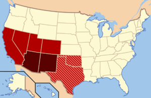
The Southwestern United States (also known as the American Southwest) is a region of the United States which includes Arizona, the western portion of New Mexico, bordered on the east by the Llano Estacado, southern Colorado and Utah below the 39th parallel, the "horn" of Texas below New Mexico, the southernmost triangle of Nevada, and the most southeastern portion of California, which encompasses the Mojave and Colorado Deserts.[2]
The population of the area is around 11 million people, with over half that in Arizona; the most populous cities are Phoenix, El Paso, Las Vegas, Albuquerque, and Tucson.
Most of the area was part of the Viceroyalty of New Spain in the Spanish Empire before becoming part of Mexico. It became part of the United States through the Treaty of Guadalupe Hidalgo and the Gadsden Purchase.
Regional geography

The geography of the region is mainly made up by four features: the Mojave, Sonoran, and Chihuahuan Deserts, and the Colorado Plateau; although there are other geographical features as well, such as a portion of the Great Basin Desert. The deserts dominate the southern and western reaches of the area, while the plateau (which is largely made up of high desert) is the main feature north of the Mogollon Rim.[3] The two major rivers of the region are the Colorado River, running in the northern and western areas, and the Rio Grande, running in the south.

Formed approximately 8000 years ago, the Chihuahuan Desert is a relatively dry desert,[4] although it is slightly wetter than the Sonoran Desert to the west.[3] The Chihuahuan Desert spreads across the southeastern portion of the region, covering from southeastern Arizona, across southern New Mexico, and the portion of Texas included in the Southwest.[4] While it is the second largest desert in the United States,[3] only a third of the desert is within the United States, with the rest in Mexico.[5] El Paso is the major city in this desert, with other smaller cities being Las Cruces and Roswell in New Mexico.[3]
The elevation in the Chihuahuan varies from 1970 to 5500 feet, as there are several smaller mountain ranges contained in the area, namely the San Andres and Doña Anas in New Mexico, and the Franklin Mountains, which span Texas and New Mexico in the Southwest region. The Chihuahuan is a "rain shadow" desert, formed between two mountain ranges (the Sierra Madre Occidental on the west and the Sierra Madre Oriental on the east) which block oceanic precipitation from reaching the area.[4] The Chihuahuan Desert is considered the "most biologically diverse desert in the Western Hemisphere and one of the most diverse in the world", and includes more species of cacti than any other desert in the world.[5] The most prolific plants in this region are agave, yucca and creosote bushes,[3] in addition to the ubiquitous cacti.

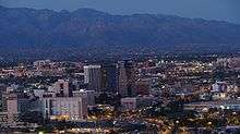
When people think of the desert southwest, the landscape of the Sonoran Desert is what mostly comes to mind.[3] The Sonoran Desert makes up the southwestern portion of the Southwest; most of the desert lies in Mexico, but its United States component lies on the southeastern border of California, and the western 2/3 of southern Arizona. Rainfall averages between 4–12 inches per year, and the desert's most widely known inhabitant is the saguaro cactus, which is unique to the desert.[6][7] It is bounded on the northwest by the Mojave Desert, to the north by the Colorado Plateau and to the east by the Arizona Mountains forests and the Chihuahuan Desert.[8] Aside from the trademark saguaro, the desert has the most diverse plant life of any desert in the world,[6] and includes many other species of cacti, including the organ-pipe, senita, prickly pear, barrel, fishhook, hedgehog, cholla, silver dollar, and jojoba.[6][7] The portion of the Sonora Desert which lies in the Southwestern United States is the most populated area within the region. Six of the top ten major population centers of the region are found within its borders: Phoenix, Tucson, Mesa, Chandler, Glendale, and Scottsdale, all in Arizona. Also within its borders are Yuma and Prescott Arizona.[3]
The most northwest portion of the American Southwest is covered by the Mojave Desert. Bordered on the south by the Sonoran Desert and the east by the Colorado Plateau, its range within the region makes up the southeast tip of Nevada, and the northwestern corner of Arizona.[7] In terms of topography, the Mojave is very similar to the Great Basin Desert, which lies just to its north.[3] Within the region, Las Vegas is the most populous city; other significant areas of human habitation include Laughlin and Pahrump in Nevada, and Lake Havasu City, Kingman, and Bullhead City in Arizona. The Mojave is the smallest, driest and hottest desert within the United States.[7] The Mojave gets less than six inches of rain annually, and its elevation ranges from 3000 to 6000 feet above sea level.[9] The most prolific vegetation is the tall Joshua tree, which grow as tall as 40 feet, and are thought to live almost 1000 years.[7] Other major vegetation includes the Parry saltbush and the Mojave sage, both only found in the Mojave, as well as the creosote bush.[10]
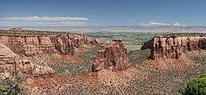
The Colorado Plateau varies from the large stands of forests in the west, including the largest stand of ponderosa pine trees in the world, to the Mesas to the east.[11] Although not called a desert, the Colorado Plateau is mostly made up of high desert. Within the Southwest U.S. region, the Colorado is bordered to the south by the Mogollon Rim and the Sonoran Desert, to the west by the Mojave Desert, and to the east by the Rocky Mountains and the Llano Estacado.[7] The Plateau is characterized by a series of plateaus and mesas, interspersed with canyons.[7] The most dramatic example is the Grand Canyon.[12] But that is one of many dramatic vistas included within the Plateau, which includes spectacular lava formations, "painted" deserts, sand dunes, and badlands.[13] One of the most distinctive features of the Plateau is its longevity, having come into existence at least 500 million years ago.[14] The Plateau can be divided into six sections, three of which fall into the Southwest region. Beginning with the Navaho section forming the northern boundary of the Southwestern United States, which has shallower canyons than those in the Canyonlands section just to its north; the Navaho section is bordered to the south by the Grand Canyon section, which of course is dominated by the Grand Canyon; and the southeastern-most portion of the Plateau is the Datil section, consisting of valleys, mesas, and volcanic formations.[15] Albuquerque is the most populous city within the portion contained in the Southwest region, but Sante Fe, New Mexico and Flagstaff, Arizona, are also significant population centers.
.jpg)
Geographer D. W. Meinig defines the Southwest in a very similar fashion to Reed: the portion of New Mexico west of the Llano Estacado and the portion of Arizona east of the Mojave-Sonoran Desert and south of the "canyon lands" and also including the El Paso district of western Texas and the southernmost part of Colorado.[16] Meinig breaks the Southwest down into four distinct subregions. He calls the first subregion "Northern New Mexico", and describes it as focused on Albuquerque and Santa Fe. It extends from the San Luis Valley of southern Colorado to south of Socorro and including the Manzano Mountains, with an east-west breadth in the north stretching from the upper Canadian River to the upper San Juan River. The area around Albuquerque is sometimes called Central New Mexico.
"Central Arizona" is a vast metropolitan area spread across one contiguous sprawling oasis, essentially equivalent to the Phoenix metropolitan area. The city of Phoenix is the largest urban center, and located in the approximate center of the area that includes Tempe, Mesa, and many others.[17]
Meinig calls the third subregion "El Paso, Tucson, and the Southern Borderlands". While El Paso and Tucson are distinctly different cities, they serve as anchor points to the hinterland between them. Tucson occupies a large oasis at the western end of the El Paso-Tucson corridor. The region between the two cities is a major transportation trunk with settlements servicing both highway and railway needs. There are also large mining operations, ranches, and agricultural oases. Both El Paso and Tucson have large military installations nearby; Fort Bliss and White Sands Missile Range north of El Paso in New Mexico, and, near Tucson, the Davis-Monthan Air Force Base. About 70 miles (110 km) to the southeast are the research facilities at Fort Huachuca. These military installations form a kind of hinterland around the El Paso-Tucson region, and are served by scientific and residential communities such as Sierra Vista, Las Cruces, and Alamogordo. El Paso's influence extends north into the Mesilla Valley, and southeast along the Rio Grande into the Trans-Pecos region of Texas.[18]
The fourth subregion Meinig calls the "Northern Corridor and Navaholands". A major highway and railway trunk which connects Albuquerque and Flagstaff. Just north of the transportation trunk are large blocks of American Indian land.[19]
Phoenix, Tucson, and Las Vegas dominate the westernmost metropolitan areas in the Southwest, while Albuquerque, and El Paso dominate the easternmost metropolitan areas.[20]
History
Pre-European contact
Human history in the Southwest begins with the arrival of the Clovis culture, a Paleo-Indian hunter-gatherer culture which arrived sometime around 9000 BC.[21] This culture remained in the area for several millennia. At some point they were replaced by three great Pre-Columbian Indian cultures: the Ancestral Pueblo people, the Hohokam, and the Mogollon, all of which existed among other surrounding cultures including the Fremont and Patayan.[22] Maize began to be cultivated in the region sometime during the early first millennium BC, but it took several hundred years for the native cultures to be dependent on it as a food source.[23] As their dependence on maize grew, Pre-Columbian Indians began developing irrigation systems around 1500.[24]

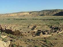
According to archeological finds, the Ancestral Pueblo people, also known as the Anasazi (although that term is becoming more and more disused), began settling in the area in approximately 1500 BC.[25] Eventually, they would spread throughout the entire northern section of the Southwest.[26] This culture would go through several different eras lasting from approximately 1500 BC through the middle of the 15th century AD: the Basketmaker I, II, and III phases followed by the Pueblo I, II, III, and IV. As the Puebloans transitioned from a nomadic lifestyle to one based on agriculture, their first domiciles were pithouses.[25] The Mogollon culture developed later than the Puebloan, arising in the eastern area of the region at around 300 BC.[27] Their range would eventually extend deep into what would become Mexico, and dominate the southeastern portion of the Southwest.[28] Their settlements would evolve over time from pit-dwellings through pueblos and finally also incorporating cliff-dwellings. The Hohokam were the last of these ancestral cultures to develop, somewhere around 1 AD, but they would grow to be the most populous of the three by 1300 AD, despite being the smallest of the three in terms of area, covering most of the southwest portion.[29] Beginning in approximately 600 AD, the Hohokam began to develop an extensive series of irrigation canals;[30] of the three major cultures in the Southwest, only the Hohokam developed irrigation as a means of watering their agriculture.[29]
Not long after the Hohokam reached the height of their culture, all three major cultures in the Southwest began to decline, for unknown reasons, although severe drought and encroachment from other peoples has been postulated. By the end of the 15th century, all three cultures had disappeared. The modern Indian tribes of the Hopi, Zuni, Acoma, and Laguna trace their ancestry back to the ancestral Puebloans,[31] while the Akimel O'odham and Tohono O'odham claim descent from Hohokam.[32] The area previously occupied by the Mogollon was taken over by an unrelated tribe, the Apache.[33] While it is unclear whether any of the modern Indian tribes are descended from the Mogollon, some archeologists and historians believe that they mixed with Ancestral Puebloans and became part of the Hopi and Zuni.[34]

Prior to the arrival of Europeans, the Southwestern United States was inhabited by a very large population of American Indian tribes. The area once occupied by the ancestral Puebloans became inhabited by several American Indian tribes, the most populous of which were the Navajo, Ute, Southern Paiute, and Hopi. The Navajo, along with the Hopi, were the earliest of the modern Indian tribes to develop in the Southwest. Around 1100 AD their culture began to develop in the Four Corners area of the region.[35] The Ute were found over most of modern-day Utah and Colorado, as well as northern New Mexico and Arizona.[36] The Paiutes roamed an area which covered over 45,000 square miles of southern Nevada and California, south-central Utah, and northern Arizona.[37] The Hopi settled the lands of the central and western portions of northern Arizona. Their village of Oraibi, settled in approximately 1100 AD, is one of the oldest continuously occupied settlements in the United States.[38] The Mogollon area became occupied by the Apaches and the Zuni. The Apache migrated into the American Southwest from the northern areas of North America at some point between 1200 and 1500.[39] They settled throughout New Mexico, eastern Arizona, northern Mexico, parts of western Texas, and southern Colorado.[40] The Zuni count their direct ancestry through the ancestral Puebloans. The modern day Zuni established a culture along the Zuni River in far-eastern Arizona and western New Mexico.[41][42] Both major tribes of the O'odham tribe settled in the southern and central Arizona, in the lands once controlled by their ancestors, the Hohokam.[43]
Arrival of Europeans
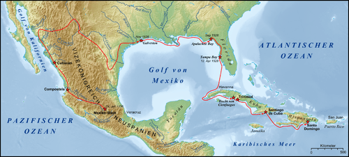
The first European intrusion into the region came from the south. In 1539, a Jesuit Franciscan named Marcos de Niza led an expedition from Mexico City which passed through eastern Arizona.[44] The following year Francisco Vázquez de Coronado, based on reports from survivors of the Narváez expedition (1528–36) who had crossed eastern Texas on their way to Mexico City, led an expedition to discover the Seven Golden Cities of Cíbola.[45] The 1582-3 expedition of Antonio de Espejo explored New Mexico and eastern Arizona;[46] and this led to Juan de Oñate's establishment of the Spanish province of Santa Fe de Nuevo México in 1598, with a capital founded near Ohkay Oweenge Pueblo, which he called San Juan de los Caballeros.[47][48] Oñate's party also attempted to establish a settlement in Arizona in 1599, but were turned back by inclement weather.[46] In 1610, Santa Fe was founded, making it the oldest capital in United States.[49]
In 1664 Juan Archuleta led an expedition into what is now Colorado, becoming the first European to enter. A second Spanish expedition was led into Colorado by Juan Ulibarrí in 1706,[50] during which he claimed the Colorado territory for Spain.[51]
From 1687 to 1691 the Jesuit priest, Eusebio Kino established several missions in the Santa Cruz River valley;[52][53] and Kino further explored southern and central Arizona in 1694, during which he discovered the ruins of Casa Grande.[45] Beginning in 1732, Spanish settlers began to enter the region, and the Spanish started bestowing land grants in Mexico and the Southwest US.[54] In 1751, the O'odham rebelled against the Spanish incursions, but the revolt was unsuccessful. In fact, it had the exact opposite effect, for the result of the rebellion was the establishment of the presidio at Tubac, the first permanent European settlement in Arizona.[55]
In 1768, the Spanish created the Provincia de las Californias, which included California and the Southwest US. Over approximately the next 50 years, the Spanish continued to explore the Southwest, and in 1776 the City of Tucson was founded when the Presidio San Augustin del Tucson was created, relocating the presidio from Tubac.[56][57]
In 1776, two Franciscan priest, Francisco Atanasio Domínguez and Silvestre Vélez de Escalante, led an expedition from Santa Fe heading to California. After passing through Colorado, they became the first Europeans to travel into what is now Utah. Their journey was halted by bad weather in October, and they turned back, heading south into Arizona before turning east back to Santa Fe.[58]

In 1804 Spain divided the Provincia de las Californias, creating the province Alta California, which consisted primarily of what would become California, Nevada, Arizona, Colorado, Utah and New Mexico. In 1821 Mexico achieved its independence from Spain and shortly after, in 1824, developed its constitution, which established the Alta California Territory, which was the same geographic area as the earlier Spanish province.
In 1825, Arizona was visited by its first non-Spanish Europeans, English trappers.[59] In 1836, the Republic of Texas, which contained the easternmost of the Southwest United States, won its independence from Mexico. In 1845 the Republic of Texas was annexed by the United States, and immediately became a state, bypassing the usual territory phase. The new state still contained portions of what would eventually become parts of other states.[60] In 1846, the Southwest became embroiled in the Mexican–American War, partly as a result of the United States' annexation of Texas. On August 18, 1846, an American force captured Santa Fe, New Mexico.[61] On December 16 of the same year, American forces captured Tucson, Arizona, marking the end of hostilities in the Southwest United States.[62] When the war ended with the Treaty of Guadalupe Hidalgo on February 2, 1848, the United States gained control of all of present-day California, Nevada and Utah, as well as the majority of Arizona, and parts of New Mexico and Colorado (the rest of present-day Colorado, and most of New Mexico had been gained by the United States in their annexation of the Republic of Texas).[63] The final portion of the Southwestern United States came about through the acquisition of the southernmost parts of Arizona and New Mexico through the Gadsden Purchase in 1853.[56]
In 1851, San Luis became the first European settlement in what is now Colorado.[64]
Becoming states


Of the states of which at least a portion make up the Southwest, Texas was the first to achieve statehood. On December 29, 1846 the Republic of Texas was annexed, bypassing becoming a territory, and immediately becoming a state.[65] Initially, its borders included parts of what would become several other states: almost half of New Mexico, a third of Colorado, and small portions of Kansas, Oklahoma, and Wyoming.[66] Texas current borders were set in the Compromise of 1850, where Texas ceded land to the federal government in exchange for $10 million, which would go to paying off the debt Texas had accumulated in its war with Mexico.[67]
Following the Mexican Cession, the lands of what had been the Mexican territory of Alta California were in flux: portions of what is now New Mexico were claimed, but never controlled, by Texas. With the Compromise of 1850, the states of Texas and California were created (Texas as a slave state, and California as a free state), as well as the Utah Territory and New Mexico Territory.[68] The New Mexico Territory consisted of most of Arizona and New Mexico (excluding a strip along their southern borders), a small section of southern Colorado, and the very southern tip of Nevada;[69] while the Utah Territory consisted of Utah, most of Nevada, and portions of Wyoming and Colorado.[70] The New Mexico Territory was expanded along its southern extent, to its current border, with the signing of the Gadsden Purchase Treaty on December 30, 1853,[56][71] which was ratified by the U.S. Congress, with some slight alterations, in April 1854.[72]


The Colorado Territory was organized on February 28, 1861, created out of lands then currently in the Utah, Kansas, Nebraska, and New Mexico territories.[73] The Nevada Territory was also organized in 1861, on March 2, with land taken from the existing Utah Territory. Initially, only the western 2/3 of what is currently the State of Nevada was included in the territory, with its boundary to the east being the 116th meridian, and to the south the 37th parallel.[74] In 1862 Nevada's eastern border shifted to the 115th meridian, and finally to its current position at the 114th meridian in 1866. The boundary modification in 1866 also included adding the southern triangular tip of the present-day state, taken from the Arizona Territory.[75][76]
From July 24–27, 1861 a confederate force under the command of Lt. Colonel John Robert Baylor forced the surrender of the small Union garrison stationed at Fort Fillmore, near Mesilla, New Mexico. On August 1, 1861, Baylor declared the creation of the Arizona Territory, and claimed it for the confederacy, with Mesilla as its capital.[77] The territory, which had been formed by the portion of the existing New Mexico Territory below the 34th parallel, became official on February 14, 1862.[78][79]


On February 24, 1863, the New Mexico Territory was split virtually in half with the creation of the Arizona Territory taking the western half.[80]
Nevada was admitted to the Union on October 31, 1864, becoming the 36th state.[81] This was followed by the admittance to the Union of Colorado, which became the 38th state on August 1, 1876.[82] Confederate Arizona was short-lived, however. By May 1862 confederate forces had been driven out of the region by union troops. That same month a bill was introduced into the U.S. Congress, and in February 24, 1863 Abraham Lincoln signed the Arizona Organic Act, which officially created the U.S. Territory of Arizona, splitting the New Mexico Territory at the 107th meridian.[83][84]
Utah, as shown above, evolved out of the Utah Territory, as pieces of the original territory created in 1850 were carved out: parts were ceded to Nevada, Wyoming, and Colorado in 1861; another section to Nevada in 1862; and the final section to Nevada in 1866.[85] In 1890, the LDS church issued the 1890 Manifesto, which officially banned polygamy for members of the church.[86] It was the last roadblock for Utah entering the Union, and on January 4, 1896 Utah was officially granted statehood, becoming the 45th state.[87]
In 1869, John Wesley Powell led a 3-month expedition which explored the Grand Canyon and the Colorado River.[88] In 1875 he would publish a book describing his explorations, Report of the Exploration of the Columbia River of the West and Its Tributaries, which was later republished as The Exploration of the Colorado River and Its Canyons.
In 1877 silver was discovered in southeastern Arizona. The notorious mining town of Tombstone, Arizona was born to service the miners.[89] The town would become immortalized as the scene of what is considered the greatest gunfight in the history of the Old West, the Gunfight at the O.K. Corral.[90]
Copper was also discovered in 1877, near Bisbee and Jerome in Arizona, which became an important component of the economy of the Southwest. Production began in 1880, and was made more profitable by the expansion of the railroad throughout the territory during the 1880s.[91]
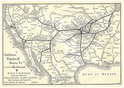
The early 1880s also saw the completion of the second transcontinental railroad, which ran through the heart of the Southwest, called the "Sante Fe Route". It ran from Chicago, down through Topeka, then further south to Albuquerque, before heading almost due west through northern Arizona to Los Angeles.[92]
The repeal of the Sherman Silver Purchase Act in 1893 led to the decline of the silver mining industry in the region.[93]
In 1901, the Santa Fe Railroad reached the south rim of the Grand Canyon, opening the way for a tourism boom,[94] a trend led by restaurant and hotel entrepreneur Fred Harvey.[95]
The last two territories within the Southwest to achieve statehood were New Mexico and Arizona. By 1863, with the splitting off of the Arizona Territory, New Mexico reached its modern borders. They became states within a month of one another. On January 6, 1912, New Mexico became the 47th state in the Union.[96] Arizona would shortly follow, becoming the last of the 48 contiguous United States on February 14, 1912.[97]
From statehood through World War II
The early 1920s saw the Ku Klux Klan gain power in Colorado; however, the organization lost traction and by the end of the decade they no longer exerted influence in the state.[98]
The 1930s saw the beginning of the ski industry in Colorado. Resorts were established in areas such as Estes Park, Gunnison, and on Loveland Pass.[99] At the end of the decade, in 1939, with the establishment of Alta Ski Area, Utah's skiing began to be developed.[100]
Due to the ski conditions in the state, during WWII, the 10th Mountain Division established Camp Hale in Colorado to train elite ski troops.[101]
The post-war years through the end of the millennium
In 1967, Governor John A. Love signed the nation's first liberalized abortion law.[102]
In 1999, the Columbine High School massacre became the most devastating high-school massacre in United States history, when two students killed 12 of their classmates and one teacher before taking their own lives.[103]
The 2000s
On July 20, 2012, Colorado became the scene of one of the largest mass shooting in U.S. history, the Aurora shooting, which resulted in the deaths of 12 people, with another 70 injured.[104][105] Also in 2012, Colorado voters passed law legalizing the recreational use of marijuana.[106]
Origins of the term and historical/cultural variations
While this article deals with the core definition for the American Southwest, there are many others. The various definitions can be broken down into four main categories: Historical/Archeological; Geological/Topographical; Ecological; and Cultural. In the 1930s and 1940s, many definitions of the Southwest included all or part of Texas, Oklahoma, New Mexico, Arizona, California, Colorado, and Utah. As time has gone on, the definition of the Southwest as become more solidified and more compact. For example, in 1948 the National Geographic Society defined the American Southwest as all of California, Nevada, Utah, Arizona, Colorado, and New Mexico, and the southernmost sections of Oregon, Idaho, and Wyoming, as well as parts of southwest Nebraska, western Kansas, Oklahoma, and Texas. By 1977, the Society's definition had narrowed to only the four states of Utah, Arizona, Colorado, and New Mexico; and by 1982 the portion of the Southwest in the United States, as defined by the Society, had shrunk to Arizona and New Mexico, with the southernmost strip of Utah and Colorado, as well as the Mojave and Colorado deserts in California.[2] Other individuals who focus on Southwest studies who favored a more limited extent of the area to center on Arizona and New Mexico, with small parts of surrounding areas, include Erna Fergusson, Charles Lummis (who claimed to have coined the term, the Southwest), and cultural geographer Raymond Gastil, and ethnologist Miguel León-Portilla.[2]
Historical/archeological
As the US expanded westward, the country's western border also shifted westward, and consequently, so did the location of the Southwestern and Northwestern United States. In the early years of the United States, newly colonized lands lying immediately west of the Appalachian Mountains were detached from North Carolina and given the name Southwest Territory. During the decades that followed, the region known as "the Southwestern United States" covered much of the Deep South east of the Mississippi River.
However, as territories and eventual states to the west were added after the Mexican–American War, the geographical "Southwest" expanded, and the relationship of these new acquisitions to the South itself became "increasingly unclear."[107]
However, archeologist, Erik Reed, gives a description which is the most widely accepted as defining the American Southwest, which runs from Durango, Colorado in the north, to Durango, Mexico, in the south, and from Las Vegas, Nevada in the west to Las Vegas, New Mexico in the East. Reed's definition is roughly equivalent to the western half of the Learning Center of the American Southwest's definition, leaving out any portion of Kansas and Oklahoma, and much of Texas, as well as the eastern half of New Mexico. Since this article is about the Southwestern United States, the areas of Sonora and Chihuahua in Mexico will be excluded. The portion left includes Arizona and western New Mexico, the very southernmost part of Utah, southwestern Colorado, the very tip of west Texas, and triangle formed by the southern tip of Nevada. This will be the defined scope which is used in this article, unless otherwise specified in a particular area.[108]
Geological/topographical
From this perspective, almost all of the region's physiographical traits, geological formations, and weather are contained within a box between 26° and 38° northern latitude, and 98° 30' and 124° western longitude.[109]
Ecological
When looking at the fauna of the region, there is a broader definition of the American Southwest. The Southwestern Center for Herpetological Research defines the Southwest as being only the states of Arizona, New Mexico, with parts of California, Nevada, Texas, and Utah; although they include all of those six states in their map of the region, solely for ease of defining the border.[110]
Cultural
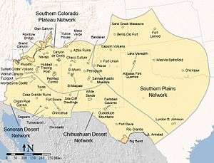
Parts of the other states make up the various areas which can be included in the Southwest, depending on the source (see Figure 1). The Learning Center of the American Southwest (LCAS)[lower-alpha 1] does not rely on current state boundaries, and defines the American Southwest as parts of Arizona, Colorado, Kansas, New Mexico, Oklahoma, Texas, and Utah (see Figure 2).[108]
Lawrence Clark Powell, a major bibliographer whose emphasis is on the Southwest, defined the American Southwest in a 1958 Arizona Highways article as, "the lands lying west of the Pecos, north of the [Mexican] Border, south of the Mesa Verde and the Grand Canyon, and east of the mountains which wall off Southern California and make it a land in itself."[2]
Texas has long been the focal point of this dichotomy, and is often considered, as such, the core area of "the South's Southwest."[107] While the Trans-Pecos area is generally acknowledged as part of the desert Southwest,[111] most of Texas and large parts of Oklahoma are often placed into a sub-region of the South, which some consider southwestern in the general framework of the original application, meaning the "Western South". This is an area containing the basic elements of Southern history, culture, politics, religion, and linguistic and settlement patterns, yet blended with traits of the frontier West. While this particular Southwest is notably different in many ways from the classic "Old South" or Southeast, these features are strong enough to give it a separate southwestern identity quite different in nature from that of the interior southwestern states to the west.
One of these distinguishing characteristics in Texas—in addition to being a Confederate state during the Civil War—is that Indigenous and Spanish American culture never played a central role in the development of this area in relative comparison to the others, as the vast majority of settlers were Anglo and blacks from the South.[112] Although the present day state of Oklahoma was Indian Territory until the early 20th century, many of these American Indians were from the southeastern United States and became culturally assimilated early on. The majority of members of these tribes also allied themselves with the Confederacy during the Civil War. Combined with that, once the territory was open for settlement, southeastern pioneers made up a disproportionate number of these newcomers. All this contributed to the new state having a character that differed from other parts of the Southwest with large American Indian populations.[112]
The fact that a majority of residents of Texas and Oklahoma—unlike those in other "southwestern" states—self-identify as living in the South and consider themselves southerners rather than the West and westerners—also lends to treating these two states as a somewhat distinct and separate entity in terms of regional classification.[113]
Vegetation and terrain

Vegetation of the southwest generally includes various types of yucca, along with saguaro cactus, barrel cactus, prickly pear cactus, desert spoon, creosote bush, sagebrush, and greasewood. Although cacti is thought to only grow in Arizona and New Mexico, many native cacti grow throughout Nevada, Utah, Colorado, and west Texas. Steppe is also located all over the high plains areas in Colorado, New Mexico, and Texas. The mountains of the southwestern states have large tracts of alpine trees.
Landscape features of the core southwestern areas include mountains, canyons, mesas, buttes, high broad basins, plateaus, desert lands, and some plains, characteristic of the Basin and Range Province. The entire southwestern region features semi-arid to arid terrain. The far eastern part of southwestern Texas, for example the Texas Hill Country, consists of dry, tall, and rugged rocky hills of limestone and granite. South Texas and the Rio Grande Valley is mostly flat with many places consisting of scrub and bare topsoil, much like the deserts further west.
Wildlife
The region has an extremely diverse bird population, with hundreds of species being found in the American Southwest. In the Chiricahua Mountains alone, in southeastern Arizona, there can be found more than 400 species. Species include Canadian (Branta canadensis) and snow geese, sandhill cranes (Grus canadensis),[114] and the roadrunner, the most famous bird in the region, is found in all states of the Southwest.[115] Birds of prey include the red-tailed hawk (Buteo jamaicensis), Cooper's hawk (Accipiter cooperii), the osprey (Pandion haliaetus), golden eagles (Aquila chrysaetos), Harris's hawk (Parabuteo unicinctus),[116] American kestrel (Falco sparverius), peregrine falcon (Falco peregrinus),[117] the gray hawk (Buteo plagiatus),[118] the barn owl (Tyto alba), the western screech owl (Megascops kennicottii), the great horned owl (Bubo virginianus), the elf owl (Micrathene whitneyi), and the burrowing owl (Athene cunicularia)[119]
Other bird species include the turkey vulture (Cathartes aura), the black vulture (Coragyps atratus),[120] the northern cardinal (Cardinalis cardinalis), the blue grosbeak (Passerina caerulea),[121] the house finch (Haemorhous mexicanus), the lesser goldfinch (Spinus psaltria),[122] the broad-billed hummingbird (Cynanthus latirostris), the black-chinned hummingbird (Archilochus alexandri), Costa's hummingbird (Calypte costae),[123] Gambel's quail (Callipepla gambelii),[124] the common raven (Corvus corax),[125] the Gila woodpecker (Melanerpes uropygialis), the gilded flicker (Colaptes chrysoides),[126] the cactus wren (Campylorhynchus brunneicapillus), and the rock wren (Salpinctes obsoletus).[127] Four types of doves call the Southwest home: the white-winged dove (Zenaida asiatica), the mourning dove (Zenaida macroura), the common ground dove (Columbina passerina), and the Inca dove (Columbina inca).[128]
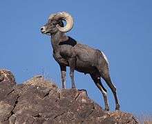
Mammal species include the bobcat, coyote, black bear, black-tailed jackrabbit, desert cottontail, desert bighorn sheep, mule deer, white-tailed deer, gray fox, mountain lion, river otter, long-tailed weasel, western spotted skunk, pronghorn, raccoon, and Ord's kangaroo rat, all of which can be found in parts of every southwestern state. Elk are found in parts of Colorado, New Mexico, Utah, and Arizona. White-nosed coati, coati, and collared peccary—or javelina—in the Southwest are normally found in southern areas of Arizona, New Mexico, and Texas near the Mexican border. Jaguars can be found in the bootheel region of Southwestern New Mexico.[129] The Mexican wolf (Canis lupus baileyi) was reintroduced to Arizona and New Mexico in 1998.[130] A U.S. Fish and Wildlife Service study reported a minimum population of 109 Mexican wolves in southwest New Mexico and southeast Arizona at the end of 2014.[131]
There is a large contingent of snakes native to the region. Among them include: the rosy boa (Lichanura trivirgata); several sub-species of the glossy snake (Arizona elegans); the Trans-Pecos ratsnake (Bogertophis subocularis); several sub-species of shovel-nosed snakes; several sub-species of kingsnake, including the desert kingsnake (Lampropeltis getula splendida) and the Arizona mountain kingsnake (Lampropeltis pyromelana); the Arizona coral snake (Micruroides euryxanthus); the western diamondback rattlesnake (Crotalus atrox); the Trans-Pecos copperhead (Agkistrodon contortrix pictigaster); the Sonoran sidewinder (Crotalus cerastes cercobombus); the Arizona black rattlesnake (Crotalus oreganus cerberus); the western rattlesnake (Crotalus viridis); the Grand Canyon rattlesnake (Crotalus oreganus abyssus), found only in Arizona; several sub-species of the ridge-nosed rattlesnake (Crotalus willardi), the most recent rattlesnake species to be discovered in the United States, including the New Mexico ridge-nosed rattlesnake (Crotalus willardi obscurus), and the Arizona ridge-nosed rattlesnake, the state reptile of Arizona; and the desert massasauga (Sistrurus catenatus edwardsii).[132]
Other reptiles in the region include lizards and turtles. Lizards are highly represented in the region, the most distinctive denizen being the Gila monster, native only to the American Southwest and the state of Sonora in Mexico. Other lizards include: Sonoran collared lizard (Crotaphytus nebrius); several types of geckos, including western banded gecko (Coleonyx variegatus), the common house gecko (Hemidactylus frenatus), and the Mediterranean house gecko (Hemidactylus turcicus), the last two species being non-native to the region but have been introduced; the desert iguana (Dipsosaurus dorsalis); the chuckwalla (Sauromalus ater); the greater earless lizard (Cophosaurus texanus scitulus); several sub-species of horned lizards (Phrynosoma); numerous species of spiny lizards (Sceloporus); Gilbert's skink (Plestiodon gilberti); the western skink (Plestiodon skiltonianus); Trans-Pecos striped whiptail (Aspidoscelis inornata heptagrammus); and the Arizona night lizard (Xantusia arizonae).[133] Turtles are less numerous than their other reptilian counterparts, but several are found in the region, including: the western painted turtle (Chrysemys picta bellii); the Rio Grande cooter (Pseudemys gorzugi); the desert box turtle (Terrapene ornata luteola); the Big Bend slider (Trachemys gaigeae gaigeae); the Sonora mud turtle (Kinosternon sonoriense); and the desert tortoise (Gopherus agassizii).[134]
Amphibians include numerous toads and frogs in the American Southwest. Toads which can be found in the region include: the Great Plains toad (Anaxyrus cognatus); the green toad (Anaxyrus debilis); the Arizona toad (Anaxyrus microscaphus); the New Mexico spadefoot (Spea multiplicata stagnalis); and the Colorado River toad (Incilius alvarius), also known as the Sonoran Desert toad. Frog representation includes: western barking frog (Craugastor augusti); the canyon tree frog (Hyla arenicolor); the Arizona treefrog (Hyla wrightorum); the western chorus frog (Pseudacris triseriata); Chiricahua leopard frog (Lithobates chiricahuensis); and the relict leopard frog (Lithobates onca). There are quite a few salamanders throughout the region, including: the Arizona tiger salamander (Ambystoma mavortium nebulosum) and the painted ensatina (Ensatina eschscholtzii picta).[135]
Climate

The southwestern United States features a semi-arid to arid climate, depending on the location. Much of the Southwest is an arid desert climate, but higher elevations in the mountains in each state, with the exception of West Texas, feature alpine climates with very large amounts of snow. The metropolitan areas of Phoenix, Tucson, Las Vegas, and El Paso hardly ever receive any snow at all, as they are strictly desert lands with mountains. Albuquerque receives less snow than other cities, but still receive significant snowfalls in the winter time. Although it snows in this region, the snow in this part of the United States melts rapidly, often before nightfall. This is due mainly to the higher altitude and abundant sunshine in these states.
Nevada and Arizona are both generally arid with desert lands and mountains, and receive large amounts of snow in the higher elevations in and near the mountains. New Mexico, Utah, and Colorado are generally arid, with desert lands and mountains as well. They all receive decent amounts of snow and large amounts of snow in the high elevations in the mountains, although some areas in far southwestern and southern New Mexico do not receive much snow at all. West Texas is generally arid as well but does not receive the same amount of snow that the other southwestern states receive at their high elevations. The terrain of western Texas in the Southwest is the flat, rolling land of the plains, which eventually turns into a desert with some hills, and there are significant mountains as well once you reach the Trans-Pecos area.
The term "High Desert" is also synonymous with this region. The High Desert is generally defined as the Mojave Desert, which extends from inland southern California into southern Nevada, and southwestern Utah. The High Desert also extends into other parts of the Northwest, such as the Red Desert in southwestern Wyoming. The High Desert is very different from the general desert lands found in Arizona, in the Sonoran Desert. This area of the desert land generally sits at a very high elevation, much higher than the normal desert land, and can receive very cold temperatures at night in the winter (with the exception of California, southern Nevada and southwestern Utah), sometimes near zero degrees on very cold nights. The High Desert also receives a decent amount of snowfall in the winter (with the exception of California, southern Nevada and southwestern Utah) but melts very quickly.
Other areas of the Southwest may also be referred to as the "High Desert" such as the Colorado Plateau. The desert lands found in Eastern Utah, Northern Arizona, Colorado and New Mexico are usually referred to as the high desert. Colorado has scattered desert lands found in southern, southwestern, western, and the northwestern parts of the state. These scattered desert lands are located in and around areas such as, the Roan Plateau, Dinosaur National Monument, Colorado National Monument, Royal Gorge, Cortez, Dove Creek, Canyons of the Ancients National Monument, Four Corners Monument, Montrose, Blue Mesa Reservoir, Pueblo, San Luis Valley, Great Sand Dunes and Joshua Tree National Park. Besides the Chihuahuan Desert, lands in southwestern and southern New Mexico, they also have scattered desert lands in the northwestern and northern portions of their state, which is referred to as the high desert.
During El Niño, winters and springs are generally colder and wetter across southern portions of the region, while the northern portion stays warmer and drier due to a southern jet stream. Under La Niña, the opposite happens, meaning the cool and wet weather tends to stay further north.
National monuments, forests and parks

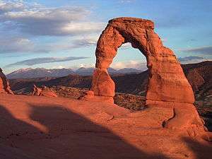
The southwestern United States contains many national monuments and parks. Some of the more famous monuments and parks in the Southwest, or along the borders with the Southwest are the Grand Canyon National Park, Navajo National Monument, Four Corners Monument, Colorado National Monument, Great Sand Dunes National Park, Arches National Park, Red Rock Canyon, Big Bend National Park, and the White Sands National Monument.

In Utah there are also many other monuments and parks such as, Mexican Hat, Bryce Canyon National Park, Canyonlands National Park, Capitol Reef National Park, Zion National Park, Dixie National Forest, Glen Canyon National Recreation Area, Grand Staircase-Escalante National Monument, Arches National Park, Manti-La Sal National Forest, Natural Bridges National Monument, Cedar Breaks National Monument, Hovenweep National Monument (also in Colorado), Monument Valley (also in Arizona), Grand Staircase-Escalante National Monument, and the Rainbow Bridge National Monument.
In Arizona there is the Agua Fria National Monument, Canyon de Chelly National Monument, Casa Grande Ruins National Monument, Chiricahua National Monument, Ironwood Forest National Monument, Montezuma Castle National Monument, Organ Pipe Cactus National Monument, Petrified Forest National Park, Pipe Spring National Monument, Saguaro National Park, Sonoran Desert National Monument, Sunset Crater Volcano National Monument, Tonto National Monument, Tumacacori National Historical Park, Tuzigoot National Monument, Vermilion Cliffs National Monument, Walnut Canyon National Monument, and the Wupatki National Monument.
In Colorado there is the Mesa Verde National Park, Royal Gorge, Blue Mesa Reservoir, Canyon of the Ancients National Monument, Yucca House National Monument, San Juan National Forest, Uncompahgre National Forest, San Isabel National Forest, Great Sand Dunes National Park and Preserve, and Bent's Old Fort National Historic Site.

In New Mexico there is the Aztec Ruins National Monument, Bandelier National Monument, Chaco Culture National Historical Park, El Malpais National Monument, El Morro National Monument, Gila Cliff Dwellings National Monument, Kasha-Katuwe Tent Rocks National Monument, Pecos National Historical Park, Petroglyph National Monument, Carson National Forest, Santa Fe National Forest, Cibola National Forest, Sevilleta National Wildlife Refuge, Apache-Sitgreaves National Forest, Gila National Forest, Coronado National Forest, Lincoln National Forest, and the Salinas Pueblo Missions National Monument.
In the western Texas part of the Southwest, there is Big Bend National Park, Chamizal National Memorial, Fort Davis National Historic Site, and the Guadalupe Mountains National Park.
In California and Nevada there is the Death Valley National Park, Joshua Tree National Park, Mojave National Preserve, Humboldt-Toiyabe National Forest, and the Lake Mead National Recreation Area.
Ethnicity


The Southwest is ethnically varied, with significant Anglo American and Hispanic American populations in addition to more regional African American, Asian American, and American Indian populations.
Hispanic Americans (mostly Mexican Americans, with large populations of Spanish Americans) can be found in large numbers in every major city in the Southwest such as El Paso (80%), Albuquerque (47%), Phoenix (43%), Tucson (41%), Las Vegas (32%).
Very large Hispanic American populations can also be found in the smaller cities such as, Flagstaff (18%), Yuma (55%), Mesa (27%), Glendale (36%), St. George (10%), Las Cruces (56%), Santa Fe (48%), and Pueblo (48%). Many small towns throughout the southwestern states also have significantly large Latino populations.
The largest African American populations in the Southwest can be found in Las Vegas (10%), and Phoenix (5%).
The largest Asian American populations in the southwest can be found in Nevada and Utah, with some significant Asian population in Phoenix. The most significant American Indian populations can be found in New Mexico and Arizona.
Cities and urban areas
The area also contains many of the nation's largest cities and metropolitan areas, despite relatively low population density in rural areas. Phoenix is the sixth most populous cities in the country, and Albuquerque and Las Vegas are some of the fastest-growing cities in America.[136][137] Also, the region as a whole has witnessed some of the highest population growth in the United States, and according to the US Census Bureau, in 2008–2009, Utah was the fastest growing state in America. As of the 2010 Census, Nevada was the fastest growing state in the United States, with an increase of 35.1% in the last ten years. Additionally, Arizona (24.6%), Utah (23.8%), Texas (20.6%), and Colorado (16.9%) were all in the top ten fastest growing states as well.[138]
Largest cities and metropolitan areas (as of 2010 census)
| Rank | City | State | Population | Metro Population |
|---|---|---|---|---|
| 1 | Phoenix | Arizona | 1,445,632[139] | 4,192,887[140] |
| 2 | El Paso | Texas | 649,133[139] | 804,123[140] |
| 3 | Las Vegas | Nevada | 583,736[139] | 1,951,269[140] |
| 4 | Albuquerque | New Mexico | 558,000[139] | 887,077[140] |
| 5 | Tucson | Arizona | 520,116[139] | 980,263[140] |
| 6 | Mesa | Arizona | 439,041[139] | 4,192,887[140] |
| 7 | Henderson | Nevada | 257,729[139] | 1,951,269[140] |
| 8 | Chandler | Arizona | 236,123[139] | 4,192,887[140] |
| 9 | Glendale | Arizona | 226,721[139] | 4,192,887[140] |
| 10 | Scottsdale | Arizona | 217,385[139] | 4,192,887[140] |
Sports
Professional
Of the four major professional sports in the United States, in the American Southwest only the Phoenix metropolitan area has representatives. And they are one of only 13 U.S. cities to have representatives in all four: Arizona Diamondbacks in Major League Baseball, Arizona Cardinals in the National Football League, the Phoenix Suns in the National Basketball Association, and the Arizona Coyotes in the National Hockey League. The Greater Phoenix area is home to the Cactus League, one of two spring training leagues for Major League Baseball; fifteen of MLB's thirty teams are now included in the Cactus League.[141] The region has also been the scene of several NFL super bowls. Sun Devil Stadium in Tempe held Super Bowl XXX in 1996, when the Dallas Cowboys defeated the Pittsburgh Steelers.[142] The University of Phoenix Stadium in Glendale, Arizona hosted Super Bowl XLII on February 3, 2008, in which the New York Giants defeated the New England Patriots,[143] as well as Super Bowl XLIX, which resulted in the New England Patriots defeating the Seattle Seahawks 28-24. The U.S. Airways Center hosted both the 1995 and the 2009 NBA All-Star Games.[144]
In 1997, the Phoenix Mercury were one of the original eight teams to launch the Women's National Basketball Association (WNBA).[145] Indoor American football is represented by the Arizona Rattlers located in Phoenix.[146] The region is also host to several major professional golf events: the LPGA's Founder's Cup;[147] the Phoenix Open and the Shriners Hospitals for Children Open (in Las Vegas) of the PGA;[148][149] and the Tucson Conquistadores Classic (in Tucson), and the Charles Schwab Cup Championship (in Scottsdale) on the Champions Tour of the PGA.[150][151]
NASCAR has two venues within the region: The Phoenix International Raceway, was built in 1964 with a one-mile oval, with a one-of-a-kind design, as well as a 2.5-mile road course,[152] and the Las Vegas Motor Speedway, a 1,200-acre (490 ha) complex of multiple tracks for motorsports racing.[153] There are several nationally recognized running events in the region, including The Phoenix Marathon, a qualifier for the Boston Marathon,[154] and the Rock 'n' Roll Marathon Series in both Phoenix and Las Vegas.[155][156] Las Vegas is also the end point for the annual Baker to Vegas Challenge Cup Relay, a 120-mile-long foot race by law enforcement teams from around the world,[157] which is the largest law enforcement athletic event in the world.[158] Las Vegas is the premier boxing venue in the country,[159] and is also known for mixed martial arts events.
The Southwest is also home to some of the most prominent rodeos in North America. The Professional Bull Riders association has its headquarters in Pueblo, Colorado. The PBR World Finals are held annually in Las Vegas,[160] which also hosts the National Finals Rodeo, which is the nation's premier rodeo event.[161] Other major rodeo events include the week-long Fiesta de los Vaqueros in Tucson,[162] the World's Oldest Rodeo in Prescott, Arizona,[163] the Southwestern International PRCA Rodeo in El Paso, Texas,[164] and the Rodeo de Santa Fe, one of the nation's premier rodeos.[165]
College
The Southwest is home to a rich tradition of college sports. The Pac-12 Conference has two teams in the region, the Arizona State Sun Devils and the University of Arizona Wildcats. The Mountain West Conference also has two teams, the UNLV Rebels and the University of New Mexico Lobos. Conference USA is represented by the University of Texas at El Paso Miners. The Big Sky Conference has two teams: the Lumberjacks of Northern Arizona University in Flagstaff, Arizona, and the Southern Utah University Thunderbirds in Cedar City, Utah. The Western Athletic Conference also has two representatives, the New Mexico State University Aggies in Las Cruces, New Mexico, and the Grand Canyon University Antelopes in Phoenix.
Las Vegas is becoming the nexus for NCAA league basketball tournaments. The Mountain West Conference, the Western Athletic Conference, the West Coast Conference, and the Pac-12 Conference all hold their conference basketball tournaments in Las Vegas.[166]
The Southwest is the site of six college football bowl games: the TicketCity Cactus Bowl, formerly known as the Insight Bowl, in Tempe;[167] the Arizona Bowl in Tucson; the Fiesta Bowl, played at the University of Phoenix Stadium;[168] the Las Vegas Bowl;[169] the New Mexico Bowl in Albuquerque;[170] and the Sun Bowl in El Paso, Texas.[171]
The erstwhile [20th century] "Southwest Conference" might "seem" to have been named after this region, but it had no teams from Arizona nor New Mexico. All but one of its teams were from schools in Texas.[172]
Politics of Southwestern states
See also
Notes
- ↑ Quote:"The Learning Center of the American Southwest is a collaboration among 48 national park units in four NPS Inventory and Monitoring Networks, three Cooperative Ecosystem Studies Units (CESUs), and several nonprofit partners. This partnership is dedicated to understanding and preserving the unique resources of the American Southwest through science and education."
References
- ↑ "Census Regions and Divisions of the United States" (PDF). census.gov. U.S. Department of Commerce, Economics and Statistics Administration, U.S. Census Bureau, Geography Division. n.d. Archived from the original on 2013-12-28. Retrieved 2016-11-27.
PDF file link under General Reference Maps on census.gov/geo/maps-data/maps/reference.html
- 1 2 3 4 Wilder, Joseph Carlton (ed.). "The Problem: No Consistent Definition". University of Arizona. Retrieved July 11, 2015.
- 1 2 3 4 5 6 7 8 "Deserts of Southwest USA". The American Southwest. Retrieved July 6, 2015.
- 1 2 3 "The Chihuahuan Desert". New Mexico State University. Retrieved July 6, 2015.
- 1 2 "Chihuahuan Desert". National Park Service. Retrieved July 6, 2015.
- 1 2 3 "Southern North America: Southwestern United States into northwestern Mexico". World Wildlife Fund. Retrieved July 6, 2015.
- 1 2 3 4 5 6 7 Green, Kim & Don (October 1, 2001). "The American Southwest; Footsteps of the Ancients Expedition". Lonely Planet. Retrieved July 6, 2015.
- ↑ "The Geologic Origin of the Sonoran Desert". Arizona-Sonora Desert Museum. Retrieved July 6, 2015.
- ↑ "What & Where is the Mojave Desert?". Digital-Desert. Retrieved July 6, 2015.
- ↑ "Mojave Desert". National Park Service. Retrieved July 6, 2015.
- ↑ "Community Responses to Wildland Fire Threats in Arizona". North Carolina State University. Retrieved July 2, 2015.
- ↑ "Colorado Plateau". The Arizona Experience. Retrieved July 6, 2015.
- ↑ Wheeler, Ray. "The Colorado Plateau Region (page 4 of 4)". Northern Arizona University. Retrieved July 6, 2015.
- ↑ Wheeler, Ray. "The Colorado Plateau Region (page 1 of 4)". Northern Arizona University. Retrieved July 6, 2015.
- ↑ "Colorado Plateau". Encyclopedia Brittanica. Retrieved July 6, 2015.
- ↑ Meinig, pp. 3–8
- ↑ Meinig, pp. 103–106
- ↑ Meinig, pp. 112–114
- ↑ Meinig, pp. 114–119
- ↑ Meinig, pp. 123–136
- ↑ Sheridan 2012, pp. 11–12.
- ↑ Archaeology of prehistoric native America: an encyclopedia, By Guy E. Gibbon, Kenneth M. Ames
- ↑ "Peoples of the Mesa Verde Region: Overview". Crow Canyon Archaeological Center. Retrieved July 8, 2015.
- ↑ Sheridan 2012, p. 6.
- 1 2 "Ancestral Pueblo; Basketmaker II". Northern Arizona University. Retrieved July 7, 2015.
- ↑ Nash, Gary B. Red, White and Black: The Peoples of Early North America Los Angeles 2015. Chapter 1, pg. 4
- ↑ Jennings, J. D. World of the American Indian. National Geographic Society. p. 56. ISBN 0870449729.
- ↑ Mogollon. XII. Encyclopedia Brittanica. 1957. p. 204. Retrieved July 8, 2015.
- 1 2 "The Hohokam". Arizona Museum of Natural History, City of Mesa. Retrieved November 30, 2012.
- ↑ Sheridan 2012, pp. 22–24.
- ↑ "Ancestral Pueblo culture". Encyclopedia Britannica. Retrieved July 8, 2015.
- ↑ "Hohokam Canals: Prehistoric Engineering". The Arizona Experience. Retrieved July 8, 2015.
- ↑ Skibo et al. 2007, p. 234.
- ↑ Gregory, David A.; Willcox, David A. Willcox (2007). Zuni Origins: Toward a New Synthesis of Southwestern Archaeology. Tucson: University of Arizona Press. ISBN 9780816524860.
- ↑ "Navajo History". Navajo People. Retrieved July 8, 2015.
- ↑ "History of the Southern Ute". Southern Ute Indian Tribe. Retrieved July 8, 2015.
- ↑ "History: The Paiutes". Utah American Indian Digital Archive. Retrieved July 8, 2015.
- ↑ Casey, Robert L. (2007). 'Journey to the High Southwest. Guilford, CT: Globe Pequot Press. p. 382. ISBN 978-0-7627-4064-2.
- ↑ Roberts, Susan A.; Roberts, Calvin A. (1998). A History of New Mexico. Albuquerque, NM: University of New Mexico Press. pp. 48–49. ISBN 0-8263-1792-8.
- ↑ "Native Americans of the Southwest". American Indian History. Retrieved July 8, 2015.
- ↑ "Zuni History". Zuni Indians. Retrieved July 8, 2015.
- ↑ "History of the Great Zuni People". Manataka American Indian Council. Retrieved July 8, 2015.
- ↑ "History & Culture". Tohono O'odham Nation. Retrieved July 8, 2015.
- ↑ "The journey of Coronado, 1540–1542: from the city of Mexico to the Grand ..." by Pedro de Castañeda de Nájera, Antonio de Mendoza, Juan Camilo, p.5 (Google Books ISBN 1-55591-066-1)
- 1 2 "A Brief History of the Casa Grande Ruins". National Park Service. Retrieved June 30, 2015.
- 1 2 Sheridan 2012, p. 38.
- ↑ "San Juan Pueblo". New Mexico Magazine.
- ↑ Simmons, Marc, The Last Conquistador Norman: U of OK Press, 1992, pp.96, 111
- ↑ McNitt, Frank. Navajo Wars: Military Campaigns, Slave Raids, and Reprisals. Albuquerque: U of NM Press, 1972, pp. 10–11
- ↑ "A General History Of Colorado". The Geo Zone. Retrieved July 9, 2015.
- ↑ "Spanish Explorers: The Quest for Gold". Explore-Old-West-Colorado.com. Retrieved July 9, 2015.
- ↑ Sheridan 2012, p. 41.
- ↑ Kessell, John L. (1970). Mission of Sorrow: Jesuit Guevavi and the Pimas, 1691–1767. Tucson, AZ: University of Arizona Press.
- ↑ Sheridan 2012, p. 42.
- ↑ Sheridan 2012, p. 43.
- 1 2 3 "Tucson", Encyclopaedia Britannica (11th ed.), New York: Encyclopaedia Britannica Co., 1910, OCLC 14782424
- ↑ Sheridan 2012, p. 46.
- ↑ "Domínguez and Escalante Expedition Year 1775". Uintah Basin Teaching American History. Retrieved July 9, 2015.
- ↑ Sheridan 2012, p. 52.
- ↑ "Republic of Texas". Texas State Historical Association. Retrieved July 9, 2015.
- ↑ Groom, Winston "Kearny's March" Alfred A. Knopf, 2011 pp.89
- ↑ "Tucson P.O.", Arizona Business Directory and Gazetteer, San Francisco: W.C. Disturnell, 1881
- ↑ Spencer C. Tucker (2012). The Encyclopedia of the Mexican-American War: A Political, Social, and Military History. ABC-CLIO. p. 255. ISBN 9781851098545.
- ↑ "Town of San Luis". State of Colorado. Retrieved July 9, 2015.
- ↑ Annexation from the Handbook of Texas Online
- ↑ Compromise of 1850 from the Handbook of Texas Online
- ↑ "Compromise of 1850". Texas State Historical Association. Retrieved July 10, 2015.
- ↑ "Compromise of 1850". History.com. Retrieved July 10, 2015.
- ↑ Torrez, Robert J. "A Cuarto Centennial History of New Mexico, Chapter Six: The Territorial Period". New Mexico Genealogical Society. Retrieved July 10, 2015.
- ↑ Arave, Lynn (September 5, 2010). "Utah Territory's creation in 1850 paved way to statehood". Deseret News. Retrieved July 10, 2015.
- ↑ "The Actual Treaty". Official Gadsden Purchase Web Site. Retrieved July 10, 2015.
- ↑ Kluger, Richard (2007). Seizing Destiny: How America Grew From Sea to Shining Sea. pp. 502–3. ISBN 978-0-375-41341-4.
- ↑ Rose, Christina (February 28, 2014). "Native History: Colorado Territory Created Amidst Gold Rush". Indian Country Today Media Network. Retrieved July 10, 2015.
- ↑ "Act of Congress (1861) Organizing the Territory of Nevada" (PDF). State of Nevada. Retrieved July 10, 2015.
- ↑ Wilusz, John P. "The Colorful History of the California/Nevada State Boundary" (PDF). Department of Transportation, California. Retrieved July 10, 2015.
- ↑ Gannett, Henry (1885). Boundaries of the United States. Washington, D.C.: Washington Printing Office. pp. 125–6. Retrieved July 10, 2015.
- ↑ "The Civil War". Town of Mesilla. Retrieved July 10, 2015.
- ↑ "Ordinance of Secession of the Arizona Territory". The Confederate War Department. Retrieved July 10, 2015.
- ↑ "Historical Development of Arizona and New Mexico Boundaries" (PDF). Arizona State University. Retrieved July 10, 2015.
- ↑ Poston, Charles Debrille (September 17, 2011). "History of the Arizona Territory". Sharlot Hall Museum. Retrieved July 10, 2015.
- ↑ "Nevada Admitted to Union, 1864". The American History and Genealogy Project. Retrieved July 10, 2015.
- ↑ President of the United States of America (August 1, 1876). "Proclamation of the Admission of Colorado to the Union" (php). The American Presidency Project. Retrieved July 10, 2015.
- ↑ Stanley, John (April 15, 2014). "Arizona Explained: How statehood happened". Arizona Republic. Retrieved July 10, 2015.
- ↑ "Tag Archives: Arizona's Organic Act". Sharlot Hall Museum. Retrieved July 10, 2015.
- ↑ Gannett 1885, p. 124.
- ↑ "The Manifesto and the End of Plural Marriage". The Church of Jesus Christ of Latter Day Saints. Retrieved July 10, 2015.
- ↑ "Utah Statehood". State of Utah. Retrieved July 10, 2015.
- ↑ "The Beginnings of the U.S. Geological Survey". National Atlas of the United States. 2010. Retrieved October 9, 2010.
- ↑ Eric L. Clements, "Bust and bust in the mining West," Journal of the West (Oct 1996) 35#4 pp 40–53
- ↑ Hubert I. Cohen, "Wyatt Earp at the O. K. Corral: Six Versions," Journal of American Culture, (June 2003) 26#2 pp 204–223
- ↑ "A History of Mining in AZ" (PDF). Arizona Mining Association. pp. 10–11. Retrieved July 11, 2015.
- ↑ Drury, George H. (1992). The Train-Watcher's Guide to North American Railroads: A Contemporary Reference to the Major railroads of the U.S., Canada and Mexico. Waukesha, Wisconsin: Kalmbach Publishing. pp. 37–42. ISBN 0-89024-131-7.
- ↑ "A History of Mining in AZ" (PDF). Arizona Mining Association. p. 11. Retrieved July 11, 2015.
- ↑ Atchison, Topeka & Santa Fe Railway Company (1906). The Grand Canyon of Arizona: Being a Book of Words from Many Pens, about the Grand Canyon of the Colorado River in Arizona. Santa Fe Railroad. p. 121.
- ↑ Dimitri Ioannides; Dallen J. Timothy (2010). Tourism in the USA: A Spatial and Social Synthesis. Taylor & Francis. p. 21.
- ↑ Simmons, Marc (1988). New Mexico: An Interpretive History. Albuquerque: University of New Mexico Press. p. 166. ISBN 0-8263-1110-5.
- ↑ "Arizona". History.com. Retrieved July 10, 2015.
- ↑ William Wyckoff (1999). Creating Colorado: The Making of a Western American Landscape, 1860–1940. Yale UP. p. 267.
- ↑ Colorado Ski History.com. 1930–1939. Retrieved November 3, 2011
- ↑ Grass, Ray (March 9, 1999). "Alta at 60". Deseret News. p. D1. Retrieved July 10, 2015.
- ↑ 10th Mountain Division History Metropolitan State College of Denver, 2004. Retrieved January 30, 2010.
- ↑ "Colorado Abortion Law is Signed by Gov. Love". Lincoln Evening Journal. April 26, 1967. p. 2. Retrieved July 10, 2015 – via Newspapers.com.

- ↑ "Investigators focus on accomplices in school shooting". Santa Cruz Sentinel. April 28, 1999. p. 15. Retrieved July 10, 2015 – via Newspapers.com.
- ↑ "Officials release complete list of injured victims in Aurora massacre". FoxNews. January 10, 2013. Retrieved July 10, 2015.
- ↑ Brown, Jennifer (July 21, 2012). "12 shot dead, 58 wounded in Aurora movie theater during Batman premier". The Denver Post. Retrieved July 10, 2015.
- ↑ Ferner, Matt (November 6, 2012). "Amendment 64 Passes: Colorado Legalizes Marijuana For Recreational Use". Huffington Post. Retrieved July 10, 2015.
- 1 2 "Encyclopedia of Southern Culture". Charles Reagan Wilson and William Ferris. University of North Carolina Press 1989
- 1 2 3 "Defining the Southwest". Learning Center of the American Southwest. Retrieved July 2, 2015.
- ↑ Wilder, Joseph Carlton (ed.). "The Southwest Defined". University of Arizona. Retrieved July 11, 2015.
- ↑ "The American Southwest Defined". Southwestern Center for Herpetological Research. Retrieved July 13, 2015.
- ↑ "The Southwest Defined. Edited by Joseph Carlton Wilder. University of Arizona Press
- 1 2 Cultural Regions of the United States. Raymond Gastil. University of Washington Press 1975
- ↑ Southern Focus Poll 1992–1999. Odom Institute; Center for the Study of the American South.
- ↑ Sharp, Jay W. "Looking for Birds in the Southwest". DesertUSA. Retrieved July 13, 2015.
- ↑ "Greater Roadrunner". Arizona-Sonora Desert Museum. Retrieved July 13, 2015.
- ↑ "Hawks & Eagles". Arizona-Sonora Desert Museum. Retrieved July 13, 2015.
- ↑ "Caracaras & Falcons". Arizona-Sonora Desert Museum. Retrieved July 13, 2015.
- ↑ "Gray Hawk". Cornell Lab of Ornithology. Retrieved July 13, 2015.
- ↑ "Owls". Arizona-Sonora Desert Museum. Retrieved July 13, 2015.
- ↑ "Vultures". Arizona-Sonora Desert Museum. Retrieved July 13, 2015.
- ↑ "Cardinals & Grosbeaks". Arizona-Sonora Desert Museum. Retrieved July 13, 2015.
- ↑ "Finches". Arizona-Sonora Desert Museum. Retrieved July 13, 2015.
- ↑ "Hummingbirds". Arizona-Sonora Desert Museum. Retrieved July 13, 2015.
- ↑ "Quail". Arizona-Sonora Desert Museum. Retrieved July 13, 2015.
- ↑ "Common Raven". Arizona-Sonora Desert Museum. Retrieved July 13, 2015.
- ↑ "Woodpeckers". Arizona-Sonora Desert Museum. Retrieved July 13, 2015.
- ↑ "Wrens". Arizona-Sonora Desert Museum. Retrieved July 13, 2015.
- ↑ "Doves". Arizona-Sonora Desert Museum. Retrieved July 13, 2015.
- ↑ "Mammals Index Page". New Mexico Institute of Mining and Technology. Retrieved July 13, 2015.
- ↑ Paquet, P. & Carbyn, L. W. (2003). Gray wolf Canis lupus and allies", in Feldhamer, George A. et al. Wild Mammals of North America: Biology, Management, and Conservation, JHU Press, pp. 482-510, ISBN 0-8018-7416-5
- ↑ http://www.fws.gov/southwest/es/mexicanwolf/pdf/fNR_Mexican_Wolf_winter_count_joint_Feb13-2015.pdf
- ↑ "Snakes of the American Southwest". Southwestern Center for Herpetological Research. Retrieved July 13, 2015.
- ↑ "Lizards of the American Southwest". Southwestern Center for Herpetological Research. Retrieved July 13, 2015.
- ↑ "Turtles of the American Southwest". Southwestern Center for Herpetological Research. Retrieved July 13, 2015.
- ↑ "Amphibians of the American Southwest". Southwestern Center for Herpetological Research. Retrieved July 13, 2015.
- ↑ 50 most populous cities in the U.S., Infoplease.com
- ↑ "America's 20 Fastest-Growing Cities". Forbes. Retrieved July 12, 2015.
- ↑ 10 fastest-growing states
- 1 2 3 4 5 6 7 8 9 10 "Annual Estimates of the Resident Population for Incorporated Places: April 1, 2010 to July 1, 2014". U.S. Census Bureau. Retrieved July 13, 2015.
- 1 2 3 4 5 6 7 8 9 10 List of primary statistical areas of the United States
- ↑ "Sun, scenery, history mark Spring Training baseball in Arizona, Florida". MLB. Retrieved February 12, 2014.
- ↑ "Super Bowl XXX". onpointevents.com. Retrieved February 14, 2014.
- ↑ "Super Bowl XLII: Giants 17 Patriots 14; Road Warrior Giants Bring It Home". ihavenet.com. Retrieved February 14, 2014.
- ↑ "NBA All-Star Game History". NBA.com. Retrieved February 14, 2014.
- ↑ "Mercury History". Retrieved February 14, 2014.
- ↑ "Champion Arizona Rattlers to parade through Phoenix". azcentral.com. Retrieved September 10, 2014.
- ↑ "LPGA Vision for Founders Cup Now Long-Term Reality". LPGA. November 4, 2013. Retrieved February 14, 2014.
- ↑ "Waste Management Phoenix Open". wmphoenixopen.com. Retrieved February 14, 2014.
- ↑ "Shriners Hospitals for Children Open". Shriners Hospitals for Children Open. Retrieved July 14, 2015.
- ↑ "Tucson Classic added to Champions Tour schedule". PGA Tour. June 10, 2014. Retrieved June 10, 2014.
- ↑ "Charles Schwab Cup Championship". PGA Tour, Inc. Retrieved July 14, 2015.
- ↑ "Timeline". phoenixraceway.com. Retrieved February 14, 2014.
- ↑ "Las Vegas Motor Speedway". Speedway Motorsports, Inc. Retrieved July 14, 2015.
- ↑ "BMO Harris Bank Announces Multi-Year Sponsorship of The Phoenix Marathon". marketwatch. Retrieved February 12, 2014.
- ↑ "Events". competitorgroup.com. Retrieved February 12, 2014.
- ↑ "Las Vegas Strip to close for marathon runners". The San Diego Union Tribune. June 11, 2009. Retrieved August 24, 2011.
- ↑ "BakerVegas". BakerVegas. Retrieved August 7, 2012.
- ↑ "Challenge Cup "Baker To Vegas" History". Baker to Vegas. Retrieved July 14, 2015.
- ↑ Seekins, Briggs (September 15, 2013). "Ranking the Greatest Las Vegas Fights in Boxing History". The Bleacher Report. Retrieved July 14, 2015.
- ↑ "PBR World Finals". The Professional Bull Riders. Retrieved July 14, 2015.
- ↑ "About the Wrangler National Finals Rodeo". Professional Rodeo Cowboys Association. Retrieved July 14, 2015.
- ↑ "La Fiesta de los Vaqueros". Tucson Rodeo. Retrieved July 14, 2015.
- ↑ "Welcome to the World's Oldest Rodeo!". Prescott Frontier Days. Retrieved July 14, 2015.
- ↑ "Southwestern International PRCA Rodeo". ELPRODEO.COM. Retrieved July 14, 2015.
- ↑ "Rodeo de Santa Fe". Rodeo de Santa Fe. Retrieved July 14, 2015.
- ↑ Carp, Steve (March 13, 2012). "Pac-12 to bring basketball tourney to MGM Grand Garden". Las Vegas Review-Journal. Retrieved July 14, 2015.
- ↑ "Buffalo Wild Wings Bowl". football-bowl.com. Retrieved February 14, 2014.
- ↑ "Fiesta Bowl". fiestabowl.org. Retrieved February 14, 2014.
- ↑ "Royal Purple Announced as Bowl Game's Title Sponsor". Las Vegas. September 25, 2013. Retrieved July 14, 2015.
- ↑ "Gildan New Mexico Bowl". ESPN. Retrieved July 14, 2015.
- ↑ "Hyundai Sun Bowl". Sun Bowl Association. Retrieved July 14, 2015.
- ↑ "See also" [the article about the] Southwest Conference.
Bibliography
- Bozanic, Andrew D. A., "Preserving Pictures of the Past: The Packaging and Selling of the American Southwest with an Emphasis on the Historic Preservation," Nevada Historical Society Quarterly, 53 (Fall–Winter 2010), 196–214.
- Busby, Mark (2004). The Southwest: The Greenwood Encyclopedia of American Regional Cultures.
- Chávez, John R. (1984). The Lost Land: The Chicano Image of the Southwest. Albuquerque.
- De León, Arnoldo. Mexican Americans in Texas: A Brief History (2nd ed. 1999)
- Garcia, Richard A. "Changing Chicano Historiography," Reviews in American History 34.4 (2006) 521–528 in Project MUSE
- Griffin-Pierce, Trudy. Native Peoples of the Southwest (2000)
- Lamar, Howard, ed. The New Encyclopedia of the American West (Yale U.P., 1998)
- Meinig, Donald W. Southwest: Three Peoples in Geographical Change, 1600–1970, (1971), Oxford University Press, ISBN 0-19-501288-7
- Prampolini, Gaetano, and Annamaria Pinazzi (eds). "The Shade of the Saguaro/La sombra del saguaro," Firenze University Press http://www.fupress.com/ (2013)
- Weber, David J. The Mexican Frontier, 1821–1846: The American Southwest Under Mexico (1982)
External links
| Wikivoyage has a travel guide for Southwestern United States. |
- American Southwest, a National Park Service Discover Our Shared Heritage Travel Itinerary
- Water-use Trends in the Desert Southwest, 1950–2000 United States Geological Survey
Coordinates: 37°00′00″N 111°12′00″W / 37.0000°N 111.2000°W