Wild Fields
| Wild Field | |
|
| |
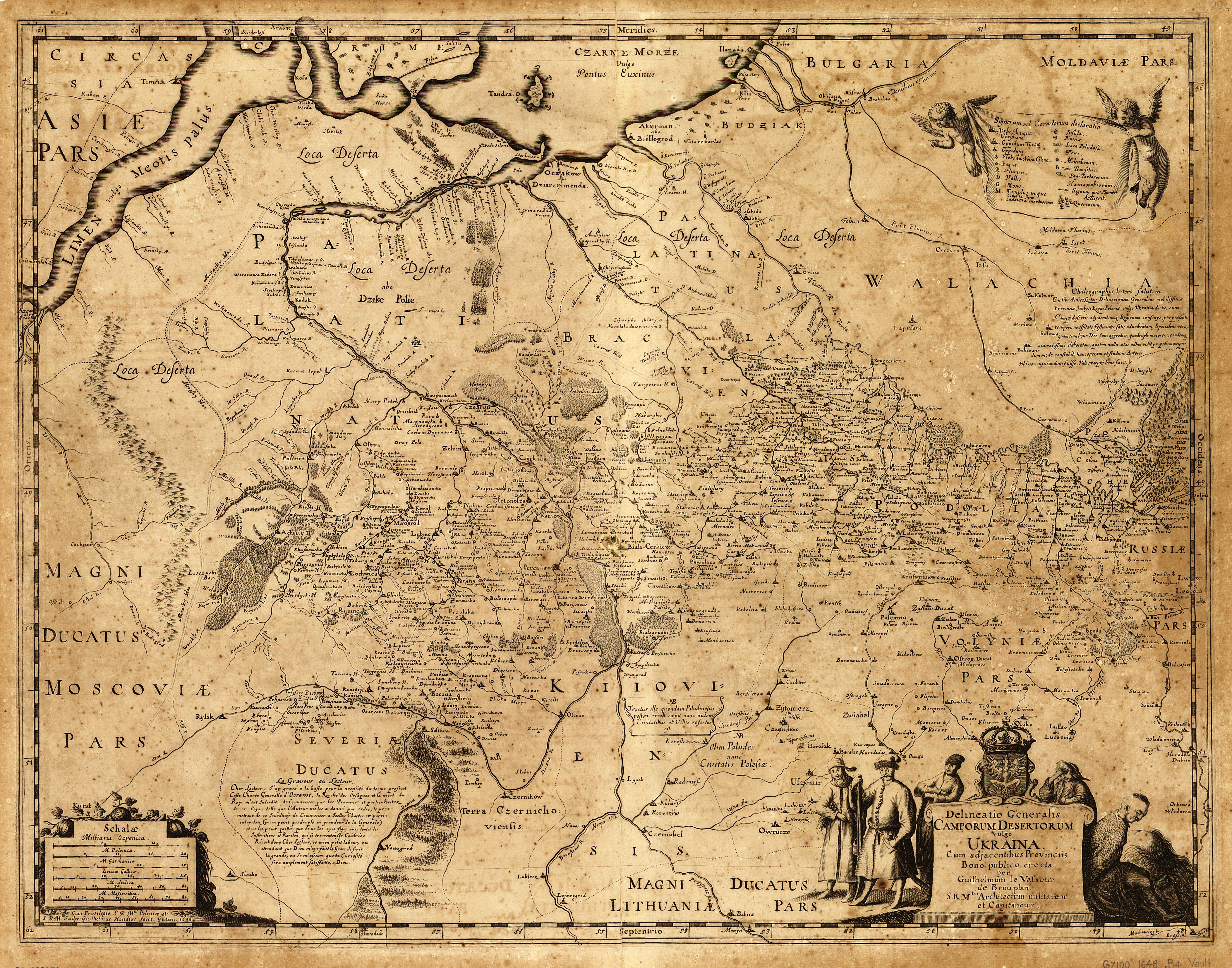
Map of the Wild Field in the 17th century | |

The Wild Fields (Ukrainian: Дике Поле Dyke Pole, Russian: Дикое Поле, Dikoye Polye, Polish: Dzikie pola, Lithuanian: Dykra, Latin: Loca deserta, sive campi deserti inhabitati, also translated as "the Wilderness") is a historical term used in the Polish–Lithuanian documents of the 16th, 17th and 18th centuries[1] to refer to the Pontic steppe north of the Black Sea and Azov Sea. The somewhat ambiguous location has been usually defined as lying between the Don River on the east, Kiev on the north, and the left tributaries of the Dniester on the west. Until the 17th and 18th centuries, the region was only sparsely populated with nomadic Nogais and consisted mostly of unpopulated steppes, so the name of "wilderness" came to be applied to it.
The territory was ruled by the Golden Horde until the Battle of Blue Waters (1362) which allowed Algirdas to claim it for the Grand Duchy of Lithuania. As a result of the Battle of the Vorskla River in 1399, his successor Vytautas lost the territory to Temur Qutlugh, the khan of the Golden Horde. In 1441 Yedisan, the western section of the Wild Fields, came to be dominated by the Crimean Khanate, a political entity controlled by the expanding Ottoman Empire from the 16th century onward.

The Wild Field was traversed by the Muravsky Trail and Izyumsky Trail, important warpaths used by the Crimean Tatars to invade and pillage the Grand Duchy of Moscow. The Crimean-Nogai Raids, a long period of raids and fighting between Crimean Tatars, Nogai Horde, Grand Duchy of Lithuania, and the Grand Duchy of Moscow, brought considerable devastation and depopulation to this area prior to the rise of the Zaporozhian Cossacks who periodically sailed down the Dnieper in dugouts from their base at Khortytsia and raided the coast of the Black Sea. The Turks built several fortress towns to defend the littoral, including Kara Kerman (Ochakiv) and Khadjibey (Odessa).
By the 17th century, the eastern part of the Wild Fields had been settled by runaway peasants and serfs who made up the core of the Cossackdom.[2] It was during the Khmelnytsky Uprising that the northern part of this area was settled by the Cossacks from the Dnieper basin and came to be known as the Sloboda Ukraine. After a series of Russo-Turkish wars waged by Catherine the Great, the area formerly controlled by the Ottomans and the Crimeans was incorporated into the Russian Empire under the name of Novorossiya. In the 20th century, the region was divided between Ukraine, Moldova, and Russia.
References
- ↑ Camporum Desertorum vulgo Ukraina by Guillaume Le Vasseur de Beauplan, Cum Privilegio S.R.M. Poloniae. Gedani 1648; Campi Deserti citra Boristhenem, abo Dzike Polie Polish–Lithuanian, by Ian Jansson, c. 1663, Amsterdam
- ↑ https://books.google.com/books?id=80lLuG3KRGIC&pg=PA127