Black Sea
| Black Sea | |
|---|---|
 | |
| Coordinates | 44°N 35°E / 44°N 35°ECoordinates: 44°N 35°E / 44°N 35°E |
| Type | Sea |
| Primary inflows | Danube, Dnieper, Rioni, Southern Bug, Kızılırmak, Dniester |
| Primary outflows | Bosphorus |
| Basin countries | Bulgaria, Georgia, Romania, Russia, Turkey, Ukraine |
| Max. length | 1,175 km (730 mi) |
| Surface area | 436,402 km2 (168,500 sq mi) |
| Average depth | 1,253 m (4,111 ft) |
| Max. depth | 2,212 m (7,257 ft) |
| Water volume | 547,000 km3 (131,200 cu mi) |
| Islands | 10+ |
%2C_with_skyline_of_Batumi_on_the_horizon.jpg)

102.jpg)
The Black Sea is a body of water between Eastern/Southeastern Europe and Western Asia, bounded by Bulgaria, Georgia, Romania, Russia, Turkey, and Ukraine.[1] It is supplied by a number of major rivers, such as the Danube, Dnieper, Rioni, Southern Bug, and Dniester. The Black Sea has an area of 436,400 km2 (168,500 sq mi) (not including the Sea of Azov),[2] a maximum depth of 2,212 m (7,257 ft),[3] and a volume of 547,000 km3 (131,000 cu mi).[4] It is constrained by the Pontic Mountains to the south and by the Caucasus Mountains to the east, and features a wide shelf to the northwest. The longest east-west extent is about 1,175 km (730 mi).
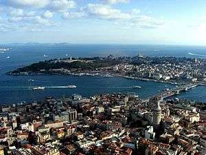
Important cities along the coast include Batumi, Burgas, Constanța, Giresun, Hopa, Istanbul, Kerch, Mangalia, Năvodari, Novorossiysk, Odessa, Ordu, Poti, Rize, Sinop, Samsun, Sevastopol, Sochi, Sozopol, Sukhumi, Trabzon, Varna, Yalta and Zonguldak.
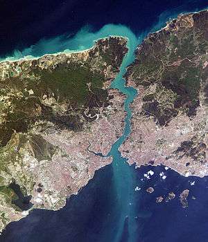
The Black Sea has a positive water balance; that is, a net outflow of water 300 km3 (72 cu mi) per year through the Bosphorus and the Dardanelles into the Aegean Sea. Mediterranean water flows into the Black Sea as part of a two-way hydrological exchange. The Black Sea outflow is cooler and less saline, and floats over the warm, more saline Mediterranean inflow – as a result of differences in density caused by differences in salinity – leading to a significant anoxic layer well below the surface waters. The Black Sea drains into the Mediterranean Sea and then the Atlantic Ocean, via the Aegean Sea and various straits. The Bosphorus Strait connects it to the Sea of Marmara, and the Strait of the Dardanelles connects that sea to the Aegean Sea region of the Mediterranean. These waters separate Eastern Europe and Western Asia. The Black Sea is also connected to the Sea of Azov by the Strait of Kerch.
The water level has varied significantly. Due to these variations in the water level in the basin, the surrounding shelf and associated aprons have sometimes been land. At certain critical water levels it is possible for connections with surrounding water bodies to become established. It is through the most active of these connective routes, the Turkish Straits, that the Black Sea joins the world ocean. When this hydrological link is not present, the Black Sea is an endorheic basin, operating independently of the global ocean system, like the Caspian Sea for example. Currently the Black Sea water level is relatively high, thus water is being exchanged with the Mediterranean. The Turkish Straits connect the Black Sea with the Aegean Sea, and comprise the Bosphorus, the Sea of Marmara and the Dardanelles.
Extent
The International Hydrographic Organization defines the limits of the Black Sea as follows:[5]
- On the Southwest. The Northeastern limit of the Sea of Marmara [A line joining Cape Rumili with Cape Anatoli (41°13'N)].
- In the Kertch Strait. A line joining Cape Takil and Cape Panaghia (45°02'N).
Population
| Most populous urban areas along the Black Sea coastline | ||||||||||
|---|---|---|---|---|---|---|---|---|---|---|
|
Rank | City | Country | Region/County | Population (urban) |
| ||||
| 1 | Istanbul | Turkey | Istanbul | 14,324,240[6] | ||||||
| 2 | Odessa | Ukraine | Odessa | 1,003,705 | ||||||
| 3 | Samsun | Turkey | Samsun | 535,401[7] | ||||||
| 4 | Varna | Bulgaria | Varna | 474,076 | ||||||
| 5 | Sevastopol | Russia (de facto)[8] | national-level municipality on the Crimean Peninsula | 379,200 | ||||||
| 6 | Sochi | Russia | Krasnodar Krai | 343,334 | ||||||
| 7 | Trabzon | Turkey | Trabzon | 305,231[9] | ||||||
| 8 | Constanța | Romania | Constanța | 283,872[10] | ||||||
| 9 | Novorossiysk | Russia | Krasnodar Krai | 241,952 | ||||||
| 10 | Burgas | Bulgaria | Burgas | 223,902[11] | ||||||
| 11 | Batumi | Georgia | Adjara | 190,405[12] | ||||||


Name


Modern names
Current names of the sea are usually equivalents of the English name "Black Sea", including these given in the countries bordering the sea:[13]
- Abkhaz: Amšyn Eik̢°a (Амшын Еиқәа, IPA: [ɑmʃɨn ɛjkʷʰɑ])
- Adyghe: Xə Ṣ̂uc̣e (Хы шӏуцӏэ, IPA: [xə ʃʼəw.t͡sʼa]), Axən (Ахын)
- Bulgarian: Cherno more (Черно море, IPA: [ˈtʃɛrno moˈrɛ])
- Georgian: Shavi zghva (შავი ზღვა, IPA: [ʃɑwi zʁwɑ])
- Laz: Uča zuɣa (უჩა ზუღა, IPA: [utʃɑ zuɣɑ]), or simply Zugha (ზუღა, "Sea")
- Romanian: Marea Neagră (pronounced [ˈmare̯a ˈne̯aɡrə])
- Russian: Chyornoye more (Чёрное мо́рe, IPA: [ˈtɕɵrnəjə ˈmorʲɪ]
- Turkish: Karadeniz (IPA: [kaˈɾadeniz])
- Ukrainian: Chorne more (Чорне море, IPA: [ˈtʃɔrnɛ ˈmɔrɛ])
Such names have not yet been shown conclusively to predate the 12th century, but there are indications that they may be considerably older.
In Greece, the historical name "Euxine Sea", which holds a different meaning (see below), is still widely used:
- Greek: Eúxeinos Póntos (Eύξεινος Πόντος); the literal Mavri Thalassa (Μαύρη Θάλασσα) is less common
The Black Sea is one of four seas named in English after common colour terms—the others being the Red Sea, the White Sea and the Yellow Sea.
Historical names
Strabo's Geographica (1.2.10) reports that in antiquity, the Black Sea was often just called "the Sea" (ὁ πόντος ho pontos). For the most part, Graeco-Roman tradition refers to the Black Sea as the "Hospitable sea", Εὔξεινος Πόντος Eúxeinos Póntos. This is a euphemism replacing an earlier "Inhospitable Sea", Πόντος Ἄξεινος Póntos Áxeinos, first attested in Pindar (c. 475 BC).
Strabo (7.3.6) thinks that the Black Sea was called "inhospitable" before Greek colonization because it was difficult to navigate, and because its shores were inhabited by savage tribes. The name was changed to "hospitable" after the Milesians had colonized the southern shoreline, the Pontus, making it part of Greek civilization.
It is also possible that the epithet Áxeinos arose by popular etymology from a Scythian word axšaina- "unlit", "dark"; the designation "Black Sea" may thus date from antiquity.
A map of Asia dating to 1570, entitled "Asiae Nova Descriptio", from Abraham Ortelius's Theatrum Orbis Terrarum, labels the sea Mar Maggior ("Great Sea", cf. Latin mare major).
English-language writers of the 18th century often used the name "Euxine Sea" (/ˈjuːksᵻn/ or /ˈjuːkˌsaɪn/) to refer to the Black Sea. Edward Gibbon, for instance, calls the sea by this name throughout The History of the Decline and Fall of the Roman Empire.[14] During the ottoman empire period, the Black Sea was called either Bahr-e Siyah or Karadeniz, both meaning "the Black Sea" in the Ottoman Turkish.
It is worthy to note, that in the tenth-century geography book Hudud al-'Alam, written in the Persian language by an unknown author, the Black Sea is called "Georgian Sea", "Sea of Georgians" ("daryä-yi Gurziyan").
Old Georgian sources of 9th-14th centuries ("The Georgian Chronicles") were using the name "Speris Zğua" (სპერის ზღუა), which means "The Sea of Speri", after the name of Kartvelian tribe Speris or Saspers, now in Turkey.
Geology and bathymetry

The geological origins of the basin can be traced back to two distinct relict back-arc basins which were initiated by the splitting of an Albian volcanic arc and the subduction of both the Paleo- and Neo-Tethys Oceans, but the timings of these events remain controversial.[15][16] Since its initiation, compressional tectonic environments led to subsidence in the basin, interspersed with extensional phases resulting in large-scale volcanism and numerous orogenies, causing the uplift of the Greater Caucasus, Pontides, Southern Crimean Peninsula and Balkanides mountain ranges.[17]
The ongoing collision between the Eurasian and African plates and westward escape of the Anatolian block along the North Anatolian Fault and East Anatolian Faults dictates the current tectonic regime,[17] which features enhanced subsidence in the Black Sea basin and significant volcanic activity in the Anatolian region.[18] It is these geological mechanisms which, in the long term, have caused the periodic isolations of the Black Sea from the rest of the global ocean system.
The modern basin is divided into two sub-basins by a convexity extending south from the Crimean Peninsula. The large shelf to the north of the basin is up to 190 km (120 mi) wide, and features a shallow apron with gradients between 1:40 and 1:1000. The southern edge around Turkey and the eastern edge around Georgia, however, are typified by a narrow shelf that rarely exceeds 20 km (12 mi) in width and a steep apron that is typically 1:40 gradient with numerous submarine canyons and channel extensions. The Euxine abyssal plain in the centre of the Black Sea reaches a maximum depth of 2,212 metres (7,257.22 feet) just south of Yalta on the Crimean Peninsula.[19]
The littoral zone of the Black Sea is often referred to as the Pontic littoral or Pontic zone.[20]
The area surrounding the Black Sea is commonly referred to as the Black Sea Region. Its northern part lies within the Chernozem belt (black soil belt) which goes from eastern Croatia (Slavonia), along the Danube (northern Serbia, northern Bulgaria (Danubian Plain) and southern Romania (Wallachian Plain)) to northeast Ukraine and further across the Central Black Earth Region and southern Russia into Siberia.[21]
Hydrology

The Black Sea is a marginal sea [22] and is the world's largest body of water with a meromictic basin.[23] The deep waters do not mix with the upper layers of water that receive oxygen from the atmosphere. As a result, over 90% of the deeper Black Sea volume is anoxic water.[24] The Black Sea's circulation patterns are primarily controlled by basin topography and fluvial inputs, which result in a strongly stratified vertical structure. Because of the extreme stratification, it is classified as a salt wedge estuary.
The Black Sea only experiences water transfer with the Mediterranean Sea, so all inflow and outflow occurs in the Bosphorus and Dardanelles. Inflow from the Mediterranean has a higher salinity and density than the outflow, creating the classical estuarine circulation. This means that inflow of dense water from Mediterranean occurs at the bottom of the basin while outflow of fresher Black Sea surface-water into the Marmara Sea occurs near the surface. Fresher surface water is the product of the fluvial inputs, and this makes the Black Sea a positive sea. The net input of freshwater creates an outflow volume about twice that of the inflow. Evaporation and precipitation are roughly equal at about 300 cubic kilometres per year (72 cu mi/a).[22]
Because of the narrowness and shallowness of the Bosphorus and Dardanelles (their respective depths are only 33 and 70 meters), inflow and outflow current speeds are high and there is significant vertical shear. This allows for turbulent mixing of the two layers.[22] Surface water leaves the Black Sea with a salinity of 17 psu and reaches the Mediterranean with a salinity of 34 psu. Likewise, inflow of the Mediterranean with salinity 38.5 psu experiences a decrease to about 34 psu.[22]
Mean surface circulation is cyclonic and waters around the perimeter of the Black Sea circulate in a basin-wide shelfbreak gyre known as the Rim Current. The Rim Current has a maximum velocity of about 50–100 cm/s. Within this feature, two smaller cyclonic gyres operate, occupying the eastern and western sectors of the basin.[22] The Eastern and Western Gyres are well-organized systems in the winter but dissipate into a series of interconnected eddies in the summer and autumn. Mesoscale activity in the peripheral flow becomes more pronounced during these warmer seasons and is subject to interannual variability.
Outside of the Rim Current, numerous quasi-permanent coastal eddies are formed as a result of upwelling around the coastal apron and "wind curl" mechanisms. The intra-annual strength of these features is controlled by seasonal atmospheric and fluvial variations. During the spring, the Batumi eddy forms in the southeastern corner of the sea.[25]
Beneath the surface waters—from about 50–100 meters—there exists a halocline that stops at the Cold Intermediate Layer (CIL). This layer is composed of cool, salty surface waters, which are the result of localized atmospheric cooling and decreased fluvial input during the winter months. It is the remnant of the winter surface mixed layer.[22] The base of the CIL is marked by a major pycnocline at about 100–200 metres (330–660 ft) and this density disparity is the major mechanism for isolation of the deep water.
Below the pycnocline is the Deep Water mass, where salinity increases to 22.3 psu and temperatures rise to around 8.9 °C.[22] The hydrochemical environment shifts from oxygenated to anoxic, as bacterial decomposition of sunken biomass utilizes all of the free oxygen. Weak geothermal heating and long residence time create a very thick convective bottom layer.[25]
Hydrochemistry
Because of the anoxic water at depth, organic matter, including anthropogenic artifacts such as boat hulls, are well preserved. During periods of high surface productivity, short-lived algal blooms form organic rich layers known as sapropels. Scientists have reported an annual phytoplankton bloom that can be seen in many NASA images of the region.[26] As a result of these characteristics the Black Sea has gained interest from the field of marine archaeology as ancient shipwrecks in excellent states of preservation have been discovered, such as the Byzantine wreck Sinop D, located in the anoxic layer off the coast of Sinop, Turkey.
Modelling shows the release of the hydrogen sulphide clouds in the event of an asteroid impact into the Black Sea would pose a threat to health—or even life—for people living on the Black Sea coast.[27]
There have been isolated reports of flares on the Black Sea occurring during thunderstorms, possibly caused by lighting igniting combustible gas seeping up from the lake depths.[28]
Ecology

The Black Sea supports an active and dynamic marine ecosystem, dominated by species suited to the brackish, nutrient-rich, conditions. As with all marine food webs, the Black Sea features a range of trophic groups, with autotrophic algae, including diatoms and dinoflagellates, acting as primary producers. The fluvial systems draining Eurasia and central Europe introduce large volumes of sediment and dissolved nutrients into the Black Sea, but distribution of these nutrients is controlled by the degree of physiochemical stratification, which is, in turn, dictated by seasonal physiographic development.[29]
During winter, strong wind promotes convective overturning and upwelling of nutrients, while high summer temperatures result in a marked vertical stratification and a warm, shallow mixed layer.[30] Day length and insolation intensity also controls the extent of the photic zone. Subsurface productivity is limited by nutrient availability, as the anoxic bottom waters act as a sink for reduced nitrate, in the form of ammonia. The benthic zone also plays an important role in Black Sea nutrient cycling, as chemosynthetic organisms and anoxic geochemical pathways recycle nutrients which can be upwelled to the photic zone, enhancing productivity.[31]
Phytoplankton

The main phytoplankton groups present in the Black Sea are dinoflagellates, diatoms, coccolithophores and cyanobacteria. Generally, the annual cycle of phytoplankton development comprises significant diatom and dinoflagellate-dominated spring production, followed by a weaker mixed assemblage of community development below the seasonal thermocline during summer months and a surface-intensified autumn production.[30][32] This pattern of productivity is also augmented by an Emiliania huxleyi bloom during the late spring and summer months.
- Annual dinoflagellate distribution is defined by an extended bloom period in subsurface waters during the late spring and summer. In November, subsurface plankton production is combined with surface production, due to vertical mixing of water masses and nutrients such as nitrite.[29] The major bloom-forming dinoflagellate species in the Black Sea is Gymnodinium sp.[33] Estimates of dinoflagellate diversity in the Black Sea range from 193[34] to 267 species.[35] This level of species richness is relatively low in comparison to the Mediterranean Sea, which is attributable to the brackish conditions, low water transparency and presence of anoxic bottom waters. It is also possible that the low winter temperatures below 4 °C (39 °F) of the Black Sea prevent thermophilous species from becoming established. The relatively high organic matter content of Black Sea surface water favour the development of heterotrophic (an organism which uses organic carbon for growth) and mixotrophic dinoflagellates species (able to exploit different trophic pathways), relative to autotrophs. Despite its unique hydrographic setting, there are no confirmed endemic dinoflagellate species in the Black Sea.[35]
- The Black Sea is populated by many species of marine diatom, which commonly exist as colonies of unicellular, non-motile auto- and heterotrophic algae. The life-cycle of most diatoms can be described as 'boom and bust' and the Black Sea is no exception, with diatom blooms occurring in surface waters throughout the year, most reliably during March.[29] In simple terms, the phase of rapid population growth in diatoms is caused by the in-wash of silicon-bearing terrestrial sediments, and when the supply of silicon is exhausted, the diatoms begin to sink out of the photic zone and produce resting cysts. Additional factors such as predation by zooplankton and ammonium-based regenerated production also have a role to play in the annual diatom cycle.[29][30] Typically, Proboscia alata blooms during spring and Pseudosolenia calcar-avis blooms during the autumn.[33]
- Coccolithophores are a type of motile, autotrophic phytoplankton that produce CaCO3 plates, known as coccoliths, as part of their life cycle. In the Black Sea, the main period of coccolithophore growth occurs after the bulk of the dinoflagellate growth has taken place. In May, the dinoflagellates move below the seasonal thermocline, into deeper waters, where more nutrients are available. This permits coccolithophores to utilise the nutrients in the upper waters, and by the end of May, with favourable light and temperature conditions, growth rates reach their highest. The major bloom forming species is Emiliania huxleyi, which is also responsible for the release of dimethyl sulfide into the atmosphere. Overall, coccolithophore diversity is low in the Black Sea, and although recent sediments are dominated by E. huxleyi, Braarudosphaera bigelowii, Holocene sediments have also been shown to contain Helicopondosphaera and Discolithina species.
- Cyanobacteria are a phylum of picoplanktonic (plankton ranging in size from 0.2 to 2.0 µm) bacteria that obtain their energy via photosynthesis, and are present throughout the world's oceans. They exhibit a range of morphologiies, including filamentous colonies and biofilms. In the Black Sea, several species are present, and as an example, Synechococcus spp. can be found throughout the photic zone, although concentration decreases with increasing depth. Other factors which exert an influence on distribution include nutrient availability, predation and salinity.[36]
Endemic animal species
- The Black Sea along with the Caspian Sea is part of the Zebra mussel's native range. The mussel has been accidentally introduced around the world and become an invasive species where it has been introduced.
- The Common Carp's native range extends to The Black Sea along with the Caspian Sea and Aral Sea. Like the Zebra mussel the Common Carp is an invasive species when introduced to other habitats.
- Is another native fish that is also found in the Caspian Sea. It preys upon Zebra mussels. Like the mussels and common carp it has become invasive when introduced to other environments, like the Great Lakes.
- Marine Mammals and marine megafaunas
- Marine mammals present within the basin include two species of dolphins (common[37] and bottlenose[38]) and harbour porpoise[39] inhabit the sea although all of these are endangered due to pressures and impacts by human activities. All the three species have been classified as a distinct subspecies from those in the Mediterranean and in Atlantic Seas and endemic to Black and Azov Seas.
- Critically endangered Mediterranean monk seals were historically abundant in Black Sea, and are regarded to have become extinct from the basin since in 1997.[40] Monk seals were present at the Snake Island until 1950s, and several locations such as the Danube plavni nature reserve and Doğankent were last of hauling-out sites in post-1990.[41] Very few animals still thrive in the Sea of Marmara.[42]
Ecological effects of pollution
Since the 1960s, rapid industrial expansion along the Black Sea coast line and the construction of a major dam has significantly increased annual variability in the N:P:Si ratio in the basin. In coastal areas, the biological effect of these changes has been an increase in the frequency of monospecific phytoplankton blooms, with diatom bloom frequency increasing by a factor of 2.5 and non-diatom bloom frequency increasing by a factor of 6. The non-diatoms, such as the prymnesiophytes Emiliania huxleyi (coccolithophore), Chromulina sp., and the Euglenophyte Eutreptia lanowii are able to out-compete diatom species because of the limited availability of Si, a necessary constituent of diatom frustules.[46] As a consequence of these blooms, benthic macrophyte populations were deprived of light, while anoxia caused mass mortality in marine animals.[47][48]
The decline in macrophytes was further compounded by overfishing during the 1970s, while the invasive ctenophore Mnemiopsis reduced the biomass of copepods and other zooplankton in the late 1980s. Additionally, an alien species—the warty comb jelly (Mnemiopsis leidyi)—was able to establish itself in the basin, exploding from a few individuals to an estimated biomass of one billion metric tons.[49] The change in species composition in Black Sea waters also has consequences for hydrochemistry, as Ca-producing coccolithophores influence salinity and pH, although these ramifications have yet to be fully quantified. In central Black Sea waters, Si levels were also significantly reduced, due to a decrease in the flux of Si associated with advection across isopycnal surfaces. This phenomenon demonstrates the potential for localised alterations in Black Sea nutrient input to have basin-wide effects.
Pollution reduction and regulation efforts have led to a partial recovery of the Black Sea ecosystem during the 1990s, and an EU monitoring exercise, 'EROS21', revealed decreased N and P values, relative to the 1989 peak.[50] Recently, scientists have noted signs of ecological recovery, in part due to the construction of new sewage treatment plants in Slovakia, Hungary, Romania, and Bulgaria in connection with membership in the European Union. Mnemiopsis leidyi populations have been checked with the arrival of another alien species which feeds on them.[51]
-

Actinia
-

Blue sponge
-
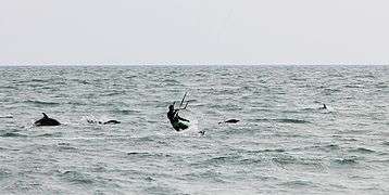
Endangered Black Sea Common Dolphins with a kite-surfer off Sochi
-

Common dolphins porpoising with a ferry at Batumi port


Climate

Short-term climatic variation in the Black Sea region is significantly influenced by the operation of the North Atlantic Oscillation, the climatic mechanisms resulting from the interaction between the north Atlantic and mid-latitude air masses.[52] While the exact mechanisms causing the North Atlantic Oscillation remain unclear,[53] it is thought the climate conditions established in western Europe mediate the heat and precipitation fluxes reaching Central Europe and Eurasia, regulating the formation of winter cyclones, which are largely responsible for regional precipitation inputs[54] and influence Mediterranean Sea Surface Temperatures (SST's).[55]
The relative strength of these systems also limits the amount of cold air arriving from northern regions during winter.[56] Other influencing factors include the regional topography, as depressions and storms systems arriving from the Mediterranean are funneled through the low land around the Bosphorus, Pontic and Caucasus mountain ranges acting as wave guides, limiting the speed and paths of cyclones passing through the region[57]
History
Mediterranean connection during the Holocene

The Black Sea is connected to the World Ocean by a chain of two shallow straits, the Dardanelles and the Bosphorus. The Dardanelles is 55 m (180 ft) deep and the Bosphorus is as shallow as 36 m (118 ft). By comparison, at the height of the last ice age, sea levels were more than 100 m (330 ft) lower than they are now.
There is also evidence that water levels in the Black Sea were considerably lower at some point during the post-glacial period. Thus, for example, archaeologists found fresh-water snail shells and man-made structures in roughly 100 m (330 ft) of water off the Black Sea coast of modern Turkey. Therefore, it is agreed that the Black Sea had been a landlocked freshwater lake (at least in upper layers) during the last glaciation and for some time after.
In the aftermath of the last glacial period, water levels in the Black Sea and the Aegean Sea rose independently until they were high enough to exchange water. The exact timeline of this development is still subject to debate. One possibility is that the Black Sea filled first, with excess fresh water flowing over the Bosphorus sill and eventually into the Mediterranean Sea. There are also catastrophic scenarios, such as the "Black Sea deluge theory" put forward by William Ryan, Walter Pitman and Petko Dimitrov.
Deluge hypothesis
The Black Sea deluge is a hypothesized catastrophic rise in the level of the Black Sea circa 5600 BC due to waters from the Mediterranean Sea breaching a sill in the Bosporus Strait. The hypothesis was headlined when The New York Times published it in December 1996, shortly before it was published in an academic journal.[58] While it is agreed that the sequence of events described did occur, there is debate over the suddenness, dating and magnitude of the events. Relevant to the hypothesis is that its description has led some to connect this catastrophe with prehistoric flood myths.[59]
Recorded history

The Black Sea was a busy waterway on the crossroads of the ancient world: the Balkans to the west, the Eurasian steppes to the north, Caucasus and Central Asia to the east, Asia Minor and Mesopotamia to the south, and Greece to the south-west.
The oldest processed gold in the world was found in Varna, and the Black Sea was supposedly sailed by the Argonauts. The land at the eastern end of the Black Sea, Colchis, (now Georgia), marked for the Greeks the edge of the known world.
The steppes to the north of the Black Sea have been suggested as the original homeland (Urheimat) of the speakers of the Proto-Indo-European language, (PIE) the progenitor of the Indo-European language family, by some scholars such as Marija Gimbutas; others move the heartland further east towards the Caspian Sea, yet others to Anatolia.
The Black Sea became an Ottoman Navy lake within five years of Genoa losing the Crimea in 1479, after which the only Western merchant vessels to sail its waters were those of Venice's old rival Ragusa. This restriction was gradually changed by the Russian Navy from 1783 until the relaxation of export controls in 1789 because of the French Revolution.[60][61]
The Black Sea was a significant naval theatre of World War I and saw both naval and land battles during World War II.
Archaeology

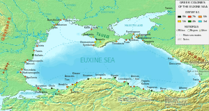
Ancient trade routes in the region are currently being extensively studied by scientists, as the Black Sea was sailed by Hittites, Carians, Colchians Thracians, Greeks, Persians, Cimmerians, Scythians, Romans, Byzantines, Goths, Huns, Avars, Bulgars, Slavs, Varangians, Crusaders, Venetians, Genoese, Lithuanians, Georgians, Poles, Tatars, Ottomans, and Russians.
Perhaps the most promising areas in deepwater archaeology are the quest for submerged prehistoric settlements in the continental shelf and for ancient shipwrecks in the anoxic zone, which are expected to be exceptionally well preserved due to the absence of oxygen. This concentration of historical powers, combined with the preservative qualities of the deep anoxic waters of the Black Sea, has attracted increased interest from marine archaeologists who have begun to discover a large number of ancient ships and organic remains in a high state of preservation.
Modern use


Commercial and civic use
According to NATO, the Black sea is a strategic corridor that provides smuggling channels for moving legal and illegal goods including drugs, radioactive materials, and counterfeit goods that can be used to finance terrorism.[62]
Navigation
Ports and ferry terminals
According to the International Transport Workers' Federation 2013 study, there were at least 30 operating merchant seaports in the Black Sea (including at least 12 in Ukraine).[63]
Merchant fleet and traffic
According to the International Transport Workers' Federation 2013 study, there were around 2,400 commercial vessels operating in the Black Sea.[63]
Fishing
Anchovy: the Turkish commercial fishing fleet catches around 300,000 tons per year on average, and fishery carried out mainly in winter and the highest portion of the stock is caught between November and December.[64]
Hydrocarbons exploration
Since the 1980s, the Soviet Union started offshore drilling for petroleum in the sea's western portion (adjoining Ukraine's coast). The independent Ukraine continued and intensified that effort within its exclusive economic zone, inviting major international oil companies for exploration. Discovery of the new, massive oilfields in the area stimulated an influx of foreign investments. It also provoked a short-term peaceful territorial dispute with Romania which was resolved in 2011 by an international court redefining the exclusive economic zones between the two countries.
Holiday resorts and spas

In the years following the end of the Cold War, the popularity of the Black Sea as a tourist destination steadily increased. Tourism at Black Sea resorts became one of the region's growth industries.[65] The following is a list of well-known Black Sea resorts:
- 2 Mai (Romania)
- Agigea (Romania)
- Ahtopol (Bulgaria)
- Amasra (Turkey)
- Anaklia (Georgia)
- Anapa (Russia)
- Albena (Bulgaria)
- Alupka (Crimea, Russia/Ukraine (disputed))
- Alushta (Crimea, Russia/Ukraine (disputed))
- Balchik (Bulgaria)
- Batumi (Georgia)
- Burgas (Bulgaria)
- Byala (Bulgaria)
- Cap Aurora (Romania)
- Chakvi (Georgia)
- Constantine and Helena (Bulgaria)
- Constanța (Romania)
- Corbu (Romania)
- Costineşti (Romania)
- Eforie (Romania)
- Emona (Bulgaria)
- Eupatoria (Crimea, Russia/Ukraine (disputed))
- Foros (Crimea, Russia/Ukraine (disputed))
- Feodosiya (Crimea, Russia/Ukraine (disputed))
- Giresun (Turkey)
- Gagra (Abkhazia, Georgia[lower-alpha 1])
- Gelendzhik (Russia)
- Golden Sands (Bulgaria)
- Gonio (Georgia)
- Gurzuf (Crimea, Russia/Ukraine (disputed))
- Hopa (Artvin, Turkey)
- Istanbul (Turkey)
- Jupiter (Romania)
- Kamchia (Bulgaria)
- Kavarna (Bulgaria)
- Kiten (Bulgaria)
- Kobuleti (Georgia)
- Koktebel (Crimea, Russia/Ukraine (disputed))
- Lozenetz (Bulgaria)
- Mamaia (Romania)
- Mangalia (Romania)
- Năvodari (Romania)
- Neptun (Romania)
- Nesebar (Bulgaria)
- Novorossiysk (Russia)
- Ordu (Turkey)
- Obzor (Bulgaria)
- Odessa (Ukraine)
- Olimp (Romania)
- Pitsunda (Abkhazia, Georgia[lower-alpha 1])
- Pomorie (Bulgaria)
- Primorsko (Bulgaria)
- Rize (Turkey)
- Rusalka (Bulgaria)
- Samsun (Turkey)
- Saturn (Romania)
- Sinop (Turkey)
- Sochi (Russia)
- Sozopol (Bulgaria)
- Sudak (Crimea, Russia/Ukraine (disputed))
- Skadovsk (Ukraine)
- Sulina (Romania)
- Sunny Beach (Bulgaria)
- Şile (Turkey)
- Sveti Vlas (Bulgaria)
- Trabzon (Turkey)
- Tsikhisdziri (Georgia)
- Tuapse (Russia)
- Ureki (Georgia)
- Vama Veche (Romania)
- Varna (Bulgaria)
- Venus (Romania)
- Yalta (Crimea, Russia/Ukraine (disputed))
- Zonguldak (Turkey)

Modern military use
International and military use of the Straits
The 1936 Montreux Convention provides for a free passage of civilian ships between the international waters of the Black and the Mediterranean Seas. However, a single country (Turkey) has a complete control over the straits connecting the two seas. The 1982 amendments to the Montreux Convention allow Turkey to close the Straits at its discretion in both wartime and peacetime.[66]
The 1936 Montreux Convention governs the passage of vessels between the Black and the Mediterranean Seas and the presence of military vessels belonging to non-littoral states in the Black Sea waters.[67]
Trans-sea cooperation
See also
- 1927 Crimean earthquakes
- Ancient Black Sea shipwrecks
- Anoxic event
- Bulgarian Black Sea Coast
- Caucasian Riviera
- Internationalization of the Danube River
- Karadeniz Technical University
- Kuma–Manych Depression
- Romanian Black Sea resorts
Notes
References
- ↑ UNEP/GRID-Arendal Maps and Graphics Library (2001). "Socio-economic indicators for the countries of the Black Sea basin". Retrieved December 11, 2010.
- ↑ Surface Area—"Black Sea Geography". University of Delaware College of Marine Studies. 2003. Retrieved April 3, 2014.
- ↑ Maximum Depth—"Europa – Gateway of the European Union Website". Environment and Enlargement – The Black Sea: Facts and Figures.
- ↑ "Unexpected changes in the oxic/anoxic interface in the Black Sea". Nature Publishing Group. March 30, 1989. Retrieved December 2, 2006.
- ↑ "Limits of Oceans and Seas, 3rd edition" (PDF). International Hydrographic Organization. 1953. Retrieved February 7, 2010.
- ↑ "Turkish Statistical Institute". Rapor.tuik.gov.tr. Retrieved January 14, 2014.
- ↑ "Turkish Statistical Institute". Rapor.tuik.gov.tr. Retrieved January 14, 2014.
- ↑ Annexation of Crimea by the Russian Federation, Wikipedia.
- ↑ "Turkish Statistical Institute". Rapor.tuik.gov.tr. Retrieved January 14, 2014.
- ↑ Stiati.ca. "Cele mai mari orase din Romania". Stiati.ca. Retrieved January 14, 2014.
- ↑ "Turkish Statistical Institute". Rapor.tuik.gov.tr. Retrieved January 14, 2014.
- ↑ "Batumi City Hall website". http://www.batumi.ge. Retrieved 2012. Check date values in:
|access-date=(help); External link in|publisher=(help) - ↑ Özhan Öztürk (2005). Karadeniz Ansiklopedik Sözlük. İstanbul: Heyamola Yayınları. pp. 617–620.
- ↑ Gibbon, Edward. The History of the Decline and Fall of the Roman Empire. Everyman's Library, 1910; reprinted 1993. ISBN 0-679-42308-7. Passim.
- ↑ McKenzie, DP (1970). "Plate tectonics of the Mediterranean region". Nature. 226 (5242): 239–43. Bibcode:1970Natur.226..239M. doi:10.1038/226239a0. PMID 16057188.
- ↑ McClusky, S.; S. Balassanian; et al. (2000). "Global Positioning System constraints on plate kinematics and dynamics in the eastern Mediterranean and Caucasus" (PDF). Journal of Geophysical Research. 105 (B3): 5695–5719. Bibcode:2000JGR...105.5695M. doi:10.1029/1999JB900351.
- 1 2 Shillington, Donna J.; White, Nicky; Minshull, Timothy A.; Edwards, Glyn R.H.; Jones, Stephen M.; Edwards, Rosemary A.; Scott, Caroline L. (2008). "Cenozoic evolution of the eastern Black Sea: A test of depth-dependent stretching models". Earth and Planetary Science Letters. 265 (3–4): 360–378. Bibcode:2008E&PSL.265..360S. doi:10.1016/j.epsl.2007.10.033.
- ↑ Nikishin, A (2003). "The Black Sea basin: tectonic history and Neogene–Quaternary rapid subsidence modelling". Sedimentary Geology. 156: 149–168. Bibcode:2003SedG..156..149N. doi:10.1016/S0037-0738(02)00286-5.
- ↑ Remote Sensing of the European Seas. 2008. p. 17. ISBN 1-4020-6771-2.
- ↑ Prothero, G.W. (1920). Anatolia. London: H.M. Stationery Office.
- ↑ "Agriculture in the Black Sea Region". Bs-agro.com. Retrieved January 14, 2014.
- 1 2 3 4 5 6 7 Descriptive Physical Oceanography. Talley, Pickard, Emery, Swift.
- ↑ "Meromictic". Merriam-webster.com. Retrieved January 14, 2014.
- ↑ "Exploring Ancient Mysteries: A Black Sea Journey". Ceoe.udel.edu. Retrieved January 14, 2014.
- 1 2 Korotaev, G. (2003). "Seasonal, interannual, and mesoscale variability of the Black Sea upper layer circulation derived from altimeter data". Journal of Geophysical Research. 108. Bibcode:2003JGRC..108.3122K. doi:10.1029/2002JC001508.
- ↑ Black Sea Becomes Turquoise earthobservatory.nasa.gov. Retrieved December 2, 2006. Archived October 28, 2008, at the Wayback Machine.
- ↑ Schuiling, Roelof Dirk; Cathcart, Richard B.; Badescu, Viorel; Isvoranu, Dragos; Pelinovsky, Efim (2006). "Asteroid impact in the Black Sea. Death by drowning or asphyxiation?". Natural Hazards. 40 (2): 327–338. doi:10.1007/s11069-006-0017-7.
- ↑ http://www.cosis.net/abstracts/EGU2007/01654/EGU2007-J-01654.pdf
- 1 2 3 4 Oguz, T.; H. W. Ducklow; et al. (1999). "A physical-biochemical model of plankton productivity and nitrogen cycling in the Black Sea" (PDF). Deep-Sea Research Part I. 46 (4): 597–636. Bibcode:1999DSRI...46..597O. doi:10.1016/S0967-0637(98)00074-0.
- 1 2 3 Oguz, T. & A. Merico (2006). "Factors controlling the summer Emiliania huxleyi bloom in the Black Sea: A modeling study" (PDF). Journal of Marine Systems. 59 (3–4): 173–188. Bibcode:2006JMS....59..173O. doi:10.1016/j.jmarsys.2005.08.002.
- ↑ Friedrich, J.; C. Dinkel; et al. (2002). "Benthic Nutrient Cycling and Diagenetic Pathways in the North-western Black Sea" (PDF). Estuarine, Coastal and Shelf Science. 54 (3): 369–383. Bibcode:2002ECSS...54..369F. doi:10.1006/ecss.2000.0653. Archived from the original (PDF) on October 4, 2011.
- ↑ Eker, E.; L. Georgieva; et al. (1999). "Phytoplankton distribution in the western and eastern Black Sea in spring and autumn 1995" (PDF). ICES Journal of Marine Science. 56: 15–22. doi:10.1006/jmsc.1999.0604.
- 1 2 Eker-Develi, E (2003). "Distribution of phytoplankton in the southern Black Sea in summer 1996, spring and autumn 1998". Journal of Marine Systems. 39 (3–4): 203–211. Bibcode:2003JMS....39..203E. doi:10.1016/S0924-7963(03)00031-9.
- ↑ Krakhmalny, A. F. (1994). "Dinophyta of the Black Sea (Brief history of investigations and species diversity)." Algologiya 4: 99–107.
- 1 2 Gomez, F. & L. Boicenco (2004). "An annotated checklist of dinoflagellates in the Black Sea" (PDF). Hydrobiologia. 517 (1): 43–59. doi:10.1023/B:HYDR.0000027336.05452.07.
- ↑ Uysal, Z (2006). "Vertical distribution of marine cyanobacteria Synechococcus spp. in the Black, Marmara, Aegean, and eastern Mediterranean seas". Deep-Sea Research Part II. 53 (17–19): 1976–1987. Bibcode:2006DSR....53.1976U. doi:10.1016/j.dsr2.2006.03.016.
- ↑ Delphinus delphis ssp. ponticus
- ↑ Tursiops truncatus ssp. ponticus
- ↑ Phocoena phocoena ssp. relicta
- ↑ Karamanlidis, A.; Dendrinos, P. (2015). "Monachus monachus". IUCN Red List of Threatened Species. IUCN. 2015: e.T13653A45227543. Retrieved 25 December 2015.
- ↑ Sergei R. Grinevetsky, Igor S. Zonn, Sergei S. Zhiltsov, Aleksey N. Kosarev, Andrey G. Kostianoy, 2014, The Black Sea Encyclopedia
- ↑ http://www.tandfonline.com/doi/abs/10.1080/09397140.2014.944438?journalCode=tzme20
- 1 2 Frantzis A., Alexiadou P., Paximadis G., Politi E., Gannier A., Corsini-Foka M. (2003). "Current knowledge of the cetacean fauna of the Greek Seas" (pdf). Journal of Cetacean Research and Management. International Whaling Commission. 5 (3): 219–232. Retrieved 2016-04-21.
- ↑ Anderson R.. 1992. Black Sea Whale Aided By Activists. Chicago Tribune. Retrieved on April 21. 2016
- ↑ Grey seal Halichoerus grypus in the Black Sea: The first case of long-term survival of an exotic pinniped
- ↑ Humborg, Christoph; Ittekkot, Venugopalan; Cociasu, Adriana; Bodungen, Bodo v. (1997). "Effect of Danube River dam on Black Sea biogeochemistry and ecosystem structure". Nature. 386 (6623): 385–388. Bibcode:1997Natur.386..385H. doi:10.1038/386385a0.
- ↑ Sburlea, A.; L. Boicenco; et al. (2006). "Aspects of eutrophication as a chemical pollution with implications on marine biota at the Romanian Black Sea shore". Chemicals as Intentional and Accidental Global Environmental Threats. NATO Security through Science Series: 357–360. doi:10.1007/978-1-4020-5098-5_28. ISBN 978-1-4020-5096-1.
- ↑ Gregoire, M.; C. Raick; et al. (2008). "Numerical modeling of the central Black Sea ecosystem functioning during the eutrophication phase". Progress in Oceanography. 76 (3): 286–333. Bibcode:2008PrOce..76..286G. doi:10.1016/j.pocean.2008.01.002.
- ↑ Colin Woodard (February 11, 2001). Ocean's end: travels through endangered seas. Basic Books. pp. 1–28. ISBN 978-0-465-01571-9. Retrieved August 1, 2011.
- ↑ Lancelot, C (2002). "Modelling the Danube-influenced North-western Continental Shelf of the Black Sea. II: Ecosystem Response to Changes in Nutrient Delivery by the Danube River after its Damming in 1972" (PDF). Estuarine, Coastal and Shelf Science. 54 (3): 473–499. Bibcode:2002ECSS...54..473L. doi:10.1006/ecss.2000.0659.
- ↑ Woodard, Colin, "The Black Sea's Cautionary Tale," Congressional Quarterly Global Researcher, October 2007, pp. 244–245
- ↑ Hurrell, J. W. (1995). "Decadal Trends in the North Atlantic Oscillation: Regional Temperatures and Precipitation". Science. 269 (5224): 676–679. Bibcode:1995Sci...269..676H. doi:10.1126/science.269.5224.676. PMID 17758812.
- ↑ Lamy, F., Arz, H. W., Bond, G. C., Barh, A. and Pätzold, J. (2006). "Multicentennial-scale hydrological changes in the Black Sea and northern Red Sea during the Holocene and the Arctic/North Atlantic Oscillation" (PDF). Paleoceanography. 21. Bibcode:2006PalOc..21.1008L. doi:10.1029/2005PA001184. Archived from the original (PDF) on April 15, 2012.
- ↑ "Spatial and temporal analysis of annual rainfall variations in Turkey". International Journal of Climatology. 16: 1057–1076. Bibcode:1996IJCli..16.1057T. doi:10.1002/(SICI)1097-0088(199609)16:9<1057::AID-JOC75>3.3.CO;2-4.
- ↑ Cullen, H. M.; A. Kaplan; et al. (2002). "Impact of the North Atlantic Oscillation on Middle Eastern climate and streamflow" (PDF). Climatic Change. 55 (3): 315–338. doi:10.1023/A:1020518305517.
- ↑ Ozsoy, E. & U. Unluata (1997). "Oceanography of the Black Sea: A review of some recent results". Earth-Science Reviews. 42 (4): 231–272. Bibcode:1997ESRv...42..231O. doi:10.1016/S0012-8252(97)81859-4.
- ↑ Brody, L. R., Nestor, M.J.R. (1980). Regional Forecasting Aids for the Mediterranean Basin. Handbook for Forecasters in the Mediterranean, Naval Research Laboratory. Part 2.
- ↑ Wilford, John Noble (17 December 1996). "Geologists Link Black Sea Deluge To Farming's Rise". The New York Times. Retrieved 17 June 2013.
- ↑ William Ryan & Walter Pitman (1998). Noah's Flood: The New Scientific Discoveries About the Event That Changed History. New York: Simon & Schuster Paperbacks. ISBN 0-684-85920-3.
- ↑ David Nicolle (1989). The Venetian Empire 1200-1670. Osprey Publishing. p. 17. ISBN 978-0-85045-899-2.
- ↑ Bruce McGowan. Economic Life in Ottoman Europe: Taxation, Trade and the Struggle for Land, 1600-1800, Studies in Modern Capitalism. p. 134. ISBN 978-0-521-13536-8.
- ↑ "Black Sea Security". NATO Advanced Research Workshop. NATO. 2010. Retrieved 31 December 2010.
- 1 2 "Черное море признано одним из самых неблагоприятных мест для моряков". International Transport Workers' Federation. BlackSeaNews. May 27, 2013. Retrieved September 20, 2013.
- ↑ Turkish Black Sea Acoustic Surveys: Winter distribution of anchovy along the Turkish coast Serdar SAKINAN. Middle East Technical University - Institute of Marine Sciences
- ↑ "Bulgarian Sea Resorts". Retrieved February 2, 2007.
- ↑ "Montreaux and The Bosphorus Problem" (in Turkish).
- ↑ "Montreaux Convention and Turkey (pdf)" (PDF).
Bibliography
- Stella Ghervas, "Odessa et les confins de l'Europe: un éclairage historique", in Stella Ghervas et François Rosset (ed), Lieux d'Europe. Mythes et limites, Paris, Editions de la Maison des sciences de l'homme, 2008. ISBN 978-2-7351-1182-4
- Charles King, The Black Sea: A History, 2004, ISBN 0-19-924161-9
- William Ryan and Walter Pitman, Noah's Flood, 1999, ISBN 0-684-85920-3
- Neal Ascherson, Black Sea (Vintage 1996), ISBN 0-09-959371-8
- Özhan Öztürk. Karadeniz: Ansiklopedik Sözlük (Black Sea: Encyclopedic Dictionary). 2 Cilt (2 Volumes). Heyamola Publishing. Istanbul.2005 ISBN 975-6121-00-9.
- Rüdiger Schmitt, "Considerations on the Name of the Black Sea", in: Hellas und der griechische Osten (Saarbrücken 1996), pp. 219–224
- West, Stephanie (2003). ‘The Most Marvellous of All Seas’: the Greek Encounter with the Euxine. 50. Greece & Rome. pp. 151–167.
- Petko Dimitrov; Dimitar Dimitrov (2004). THE BLACK SEA, THE FLOOD AND THE ANCIENT MYTHS. Varna. p. 91. ISBN 954-579-335-X.
- Dimitrov, D (2010). Geology and Non-traditional resources of the Black Sea. LAP Lambert Academic Publishing. p. 244. ISBN 978-3-8383-8639-3.
External links
| Wikimedia Commons has media related to Black Sea. |
| Wikivoyage has a travel guide for Black Sea. |
- Space Monitoring of the Black Sea Coastline and Waters
- Pictures of the Black sea coast all along the Crimean peninsula
- China: China wants to build a "Black Sea" highway Agriculture in the Black Sea Region (BS-AGRO.COM)
- Black Sea Environmental Internet Node
- Black Sea Organization for Integration and Sustainable Development
- Black Sea-Mediterranean Corridor during the last 30 ky: UNESCO IGCP 521 WG12
| Countries bordering the Black Sea | |
|---|---|
| Cities | |
1 Disputed statehood — partial international recognition, but considered by most countries to be Georgian territory. | |
Georgia articles | |||||||||||||||
|---|---|---|---|---|---|---|---|---|---|---|---|---|---|---|---|
| History |  | ||||||||||||||
| Geography |
| ||||||||||||||
| Politics | |||||||||||||||
| Foreign relations | |||||||||||||||
| Economy | |||||||||||||||
| Culture |
| ||||||||||||||
| |||||||||||||||