Philippine Sea
| Philippine Sea | |
|---|---|
 | |
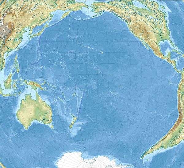 Philippine Sea Location within the Pacific Ocean | |
| Coordinates | 20°N 130°E / 20°N 130°E |
| Part of | Pacific Ocean |
| Basin countries | |
| Islands | |
| Trenches | |

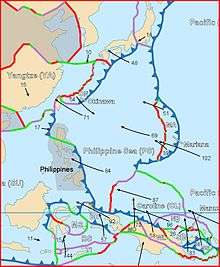
The Philippine Sea is a marginal sea east and northeast of the Philippines occupying an estimated surface area of 5 million km² (2 million mi²).[1] of the western part of the North Pacific Ocean.[2] It is bordered by the Philippine archipelago (Luzon, Catanduanes, Samar, Leyte and Mindanao) on the southwest; Halmahera, Morotai, Palau, Yap, and Ulithi (of the Carolines) on the southeast; the Marianas, including Guam, Saipan, and Tinian, on the east; the Bonin and Iwo Jima on the northeast; the Japanese islands of Honshu, Shikoku, and Kyūshū on the north; the Ryukyu Islands on the northwest; and Taiwan in the west.[3]
The sea has a complex and diverse undersea relief.[4] The floor is formed into a structural basin by a series of geologic faults and fracture zones. Island arcs, which are actually extended ridges protruding above the ocean surface due to plate tectonic activity in the area, enclose the Philippine Sea to the north, east and south. The Philippine archipelago, Ryukyu Islands, and the Marianas are examples. Another prominent feature of the Philippine Sea is the presence of deep sea trenches, among them the Philippine Trench and the Mariana Trench, containing the deepest point on the planet.
Geography
Location
The Philippine Sea is by the Philippines and Taiwan to the west, Japan to the north, the Marianas to the east and Palau to the south. Adjacent seas include Celebes Sea which is separated by Mindanao and smaller islands to the south, South China Sea which is separated by Philippines, and East China Sea which is separated by the Ryukyu Islands.
Extent
The International Hydrographic Organization defines the Philippine Sea as "that area of the North Pacific Ocean off the Eastern coasts of the Philippine Islands", bounded as follows:[5]
On the West. By the Eastern limits of the East Indian Archipelago, South China Sea and East China Sea.
On the North. By the Southeast coast of Kyushu, the Southern and Eastern limits of the Inland Sea and the South coast of Honshu Island.
On the East. By the ridge joining Japan to the Bonin, Volcano and Ladrone (Mariana) Islands, all these being included in the Philippine Sea.
On the South. By a line joining Guam, Yap, Pelew (Palau) and Halmahera Islands.
Geology
The Philippine Sea Plate forms the floor of the Philippine Sea. It subducts under the Philippine Mobile Belt which carries most of the Philippine archipelago and eastern Taiwan. Between the two plates is the Philippine Trench.
Biology
The Philippine Sea hosts an exotic marine ecosystem. About five hundred species of hard and soft corals occur in the coastal waters and 20 per cent of the worldwide known shellfish species are found in Philippine waters. Sea turtles, sharks, moray eels, octopuses and sea snakes along with numerous species of fish such as tuna can commonly be observed. Additionally, the Philippine Sea serves as spawning ground for Japanese eel, tuna and different whale species.[4]

History

The first European to navigate the Philippine Sea was Ferdinand Magellan in 1521, who named it Mar Filipinas when he and his men were in the Mariana Islands prior to the exploration of the Philippines. Later it was discovered by other Spanish explorers from 1522 to 1565 and the site of the famous galleon trade route.
Between June 19 and 20, 1944, the Battle of the Philippine Sea, a very large and decisive World War II naval battle between Japan and the United States, took place in the eastern Philippine Sea, near the Mariana Islands. The aircraft carriers Taihō, Shōkaku, Junyō, Hiyō and Ryuho were bombed, torpedoed and sunk by American carrier-based planes and assaulted from other naval vessels. The aerial part of the Battle of the Philippine Sea was nicknamed the “Great Marianas Turkey Shoot” due to massive losses of Japanese aircraft and pilots. The battle facilitated the Allied conquests of Saipan, Guam and Tinian in the Marianas, Palau in the Southwest, and ultimately the Philippines.
Following an escalation of the Spratly Islands dispute in 2011, various Philippine government agencies started using the neologism "West Philippine Sea" to refer to the South China Sea. However, a PAGASA spokesperson said that the sea to the east of the Philippines will continue to be called the Philippine Sea.[6]
See also
| Wikimedia Commons has media related to Philippine Sea. |
References
- ↑ Philippine Sea, encarta.msn.com (archived from the original on 2009-08-20).
- ↑ North Pacific Ocean
- ↑ "Philippine Sea". Encyclopædia Britannica Online. Retrieved 2008-08-12.
- 1 2 "Philippine Sea". Lighthouse Foundation. Retrieved 2008-08-12.
- ↑ "Limits of Oceans and Seas, 3rd edition" (PDF). International Hydrographic Organization. 1953. Retrieved 7 February 2010.
- ↑ Quismundo, Tarra (2011-06-13). "South China Sea renamed in the Philippines". Philippine Daily Inquirer. Retrieved 2011-06-14.
Seas of the Philippines | ||
|---|---|---|
| Ocean |  | |
| Sea | ||
| Strait |
| |
| Gulf | ||
See also: Bodies of water of the Philippines | ||
Coordinates: 20°N 130°E / 20°N 130°E