Tinian
 Tinian on an area map, southwest of Saipan, showing waters around islands, and deeper Pacific section. | |
 | |
| Geography | |
|---|---|
| Location | Pacific Ocean |
| Coordinates | 15°00′N 145°38′E / 15.000°N 145.633°E |
| Archipelago | Marianas |
| Area | 101.01 km2 (39.00 sq mi) |
| Highest elevation | 171 m (561 ft) |
| Highest point | Mount Lasso |
| Administration | |
|
United States | |
| Commonwealth | Northern Mariana Islands |
| Largest settlement | San Jose |
| Demographics | |
| Population | 3,136 (2010) |
Tinian (/ˈtɪniən/ or /ˌtiːniˈɑːn/) is one of the three principal islands of the Commonwealth of the Northern Mariana Islands. Together with uninhabited neighboring Aguijan, it forms Tinian Municipality, one of the four constituent municipalities of the Northern Marianas. Tinian's largest village is San Jose.
Geography
Tinian is about 5 nautical miles (9.3 km) southwest of Saipan, from which it is separated by the Saipan Channel. It has a land area of 39 square miles (100 km2), with its highest elevation at Mount Lasso at 171 meters (561 ft).
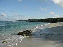
The island has a variety of flora and fauna, and limestone cliffs and caves. The Tinian monarch is the island's only endemic bird species and it is threatened by habitat loss. There is a variety of marine life and coral reefs surrounding the island. Its clear, warm waters are ideal for snorkeling, scuba diving and sport fishing.
Population
The population of Tinian was 3,136 (as of 2010), which corresponds to less than 5 percent of all residents of the Northern Mariana Islands and a population density of 35 people per km2. Most of the inhabitants are Chamorros (about 75%) and members of various other groups of islands in the Caroline Islands. There are also minorities of Filipino, Bangladeshi, East Asian and European-descended people.
History
Prehistory
Traces of human settlements on Tinian have been found by archaeologists ranging over 4,000 years, including ancient latte stones, and other artifacts pointing to cultural affinities with Melanesia and with similar stone monuments in Micronesia and Palau. Around 3000 years ago, Tinian was ruled by the Chamorro King Taga, who built a stone palace with monolithic statues and latte stones. A beach on Tinian (Taga Beach) and the local charter airline (Taga Air) were named after him.
Spanish colonial period
Tinian, together with Saipan, was possibly firstly sighted by Europeans by the Spanish expedition of Ferdinand Magellan, when it made a landfall in the southern Marianas on 6 March 1521.[1] Again, it is likely it was sighted by Gonzalo Gómez de Espinosa in 1522 on board of Spanish ship Trinidad, that in an attempt to reach Panama he commanded after the death of Ferdinand Magellan.[2] This would have happened after the sighting of the Maug Islands in between the end of August and end of September. Gonzalo de Vigo deserted in the Maugs from Gomez de Espinosa's Trinidad and in the next four years, living with the Chamorros, visited thirteen main islands in the Marianas and possibly Tinian among them. The first clear evidence of Europeans arrival was by the Manila galleon Santa Margarita commanded by Juan Martínez de Guillistegui, that wrecked in the southeast of Saipan on February 1600 and whose survivors stayed in it for two years till 250 were rescued by the Santo Tomas and the Jesus María.[3] The Spanish formally occupied Tinian in 1669, with the missionary expedition of Diego Luis de San Vitores who named it Buenavista Mariana (Goodsight Mariana). From 1670, it became a port of call for Spanish and occasional English, Dutch and French ships as a supply station for food and water. The native population, estimated at 40,000 at the time of the Spanish arrival, shrank to less than 1400 due to European-introduced diseases and conflicts over land. The survivors were forcibly relocated to Guam in 1720 for better control and assimilation. Under Spanish rule, the island was developed into ranches for raising cattle and pigs, which were used to provision Spanish galleons on their way to Mexico.
German colonial period
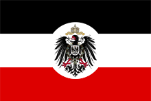
After the Spanish–American War of 1898, Tinian was occupied by the United States. However, it was then sold by Spain to the German Empire in 1899. The island was administered by Germany as part of German New Guinea, but during the German period, there was no attempt to develop or settle the island, which remained under the control of its Spanish and mestizo landowners.
Japanese colonial period

In 1914, during World War I, the island was captured by the Empire of Japan, which was awarded formal control in 1918 by the League of Nations as part of the South Pacific Mandate. The island was settled by ethnic Japanese, Koreans and Okinawans, who developed large-scale sugar plantations.[4] Under Japanese rule, extensive infrastructure development occurred, including the construction of port facilities, waterworks, power stations, paved roads and schools, along with entertainment facilities and Shinto shrines. Initial efforts to settle the island met with difficulties,including an infestation of scale insects, followed by a severe drought in 1919. However, efforts were resumed under the aegis of the Nanyo Kohatsu Kabushiki Kaisha in 1926, with new settlers from Okinawa as well as Fukushima and Yamagata Prefectures, and the introduction of coffee and cotton as cash crops in addition to sugar, and the construction of a Katsuobushi processing plant. By June 1944, some 15,700 Japanese civilians were resident on Tinian (including 2700 ethnic Koreans and 22 ethnic Chamorro).
World War II
Tinian was not garrisoned by the Japanese military until the latter stages of World War II, when the Japanese realized its strategic importance as a possible base for American Boeing B-29 Superfortress bombers. The island was seized by the Allies during the Battle of Tinian from 24 July to 1 August 1944. Of the 8500-man Japanese garrison, only 313 survived the battle. At the time, there were an estimated 15,700 Japanese civilians (including 2700 ethnic Koreans) on the island. Many hundreds were also killed in the crossfire, or either took their own lives or were executed by the Japanese military to avoid capture by the Americans.[5]
Tinian is located approximately 1,500 miles (2,400 kilometres) from mainland Japan and was suitable to become a staging base for continuous heavy bomber attacks on the Japanese Islands. Immediately after the island's seizure by the United States, construction work began on one of the largest airbases of World War II, which covered the entire island, excepting its three highland areas. The base was a 40,000-personnel installation, and the Navy Seabees (110th NCB) laid out the base in a pattern of city streets resembling New York City's Manhattan Island, and named the streets accordingly. The former Japanese town of Sunharon was nicknamed "The Village" because its location corresponded to that of Greenwich Village. A large square area between West and North Fields, used primarily for the location of the base hospitals and otherwise left undeveloped, was called Central Park.[6]
Two runway complexes, West Field and North Field, having a combined total of six 8,500-foot (2,600-meter) runways, were constructed. Today the four runways at North Field are now overgrown and abandoned. One of the two West Field runways remains in use as part of Tinian International Airport.[7]
West Field

Airfield construction was originally by the Japanese, built with two parallel runways. It was repaired by the Americans, and then called West Field.[8] From here seven squadrons of the 58th Bombardment Wing flew combat and reconnaissance missions throughout Southeast Asia and finally into the Japanese home islands, as part of the bombing of Japan.[8][9]
After World War II, West Field was Tinian's airport called Gurguan Point Airfield;[8] and today is Tinian International Airport.
North Field
The Japanese had constructed three small fighter strips[4] on Tinian, but none were suitable for bomber operations. Under the Americans, nearly the entire northern end of the island was occupied by the runways, almost 11 miles (18 km) of taxiways and the airfield area, designed to accommodate the entire 313th Bombardment Wing complement of Boeing B-29 Superfortress bombers.[4]
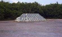
North Field was the departure point of the 509th Composite Group bombers Enola Gay and Bockscar, which carried the two atomic bombs named Little Boy and Fat Man that were dropped on Hiroshima and Nagasaki.[7]
Remains of the US bomber base and Atom Bomb Pits,[7] and the remains of Japanese fortifications, can be found at North Field. There is a memorial on the old airfield at the loading pits, which are filled in for safety. Both pits were reopened in conjunction with the 60th Anniversary Commemoration of the Battles of Saipan and Tinian. The pits were originally constructed to load the bombs, since they were too large to be loaded in the conventional manner. The B-29s were maneuvered over a pit with their bomb bay doors open to facilitate loading.[10]
Post-war Tinian
After the end of World War II, Tinian became part of the Trust Territory of the Pacific Islands, controlled by the United States. The island continued to be dominated by the United States military, and until 1962 was administered as a sub-district of Saipan. Since 1978, the island has been a municipality of the Commonwealth of the Northern Mariana Islands. During the 1980s, one of the runways on North Field was kept active to allow U.S. Air Force C-130s to take off and land in support of U.S. Marine Corps training exercises in the north end of the island. The military presence began to be replaced by tourism in the 1990s, but still plays an important role in the local economy.
Economy
Much of the local economy of Tinian is dependent on tourism. Agriculture is primarily on the subsistence level. The largest employers on the island are the government and the casino, which was legalized in 1989. As of March 2006, the island has plans to put in four new casinos. The 2010 census showed a population of 3,136[11] for the island.[12]
However, tourist infrastructure is relatively poorly developed on Tinian. The village of San Jose has several smaller hotels and restaurants and bars. Tinian Airport is small and serviced by Star Marianas Air, which operates daily scheduled flights. Freedom Air, who previously served the island filed for bankruptcy in October 2013 and suspended all operations in March 2014. The ferry boat service that operated twice daily between Tinian and Saipan ran at a loss estimated to be US$1 million a year, and has since ceased.
Local attractions
House of Taga
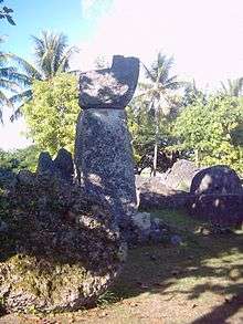
The House of Taga is a latte stone site, one of the largest such structures in the Marianas. The stones are quarried limestone, each approximately 20 feet (6.1 m) in length. Of the twelve large Latte structures, only one is still standing. The site is one of seven locations on Tinian on the National Register of Historic Places listings in the Northern Mariana Islands.
Education
Commonwealth of the Northern Mariana Islands Public School System operates public schools like the Tinian Jr. Sr. High School.
See also
References
- ↑ Rogers, Robert F.; Ballendorf, Dirk Anthony (1989). "Magellan's Landfall in the Mariana Islands". The Journal of Pacific History. Taylor & Francis Ltd. 24 (2): 198. doi:10.1080/00223348908572614.
- ↑ Brand, Donald D. The Pacific Basin: A History of its Geographical Explorations The American Geographical Society, New York, 1967, p.118.
- ↑ Sharp, Andrew (1960). The discovery oif the Pacific Islands. Oxford: Clarendon Press.
- 1 2 3 Pacifics Wrecks: Tinian History
- ↑ Prefer, Nathan N. The Battle for Tinian: Vital Stepping Stone in America's War Against Japan. Havertown, PA: Casemate Publishers, 2012. ISBN 978-1-61200-107-4. pp. 155–156.
- ↑ Carlson, Jen (2015-07-29). "These NYC Streets Are Located In The Middle Of The Pacific Ocean". Gothamist. Retrieved 2015-12-06.
- 1 2 3 Pacific Wrecks: Ushi North Field
- 1 2 3 "West Field". Pacific Wrecks.
- ↑ "A Brief History of the 58th Bomb Wing". 58th Bomb Wing Memorial.
- ↑ B-29 "Enola Gay" 44-86292 Over Atomic Bomb Loading Pit, PacificWrecks.com Retrieved 3 August 2015.
- ↑ US Census 2010
- ↑ Tinian Municipality, Tinian Island (Block Groups 1 thru 4) and Aguijan Island (Block Group 5), United States Census Bureau
External links
| Wikimedia Commons has media related to Tinian. |
| Wikivoyage has a travel guide for Tinian. |
- The Insular Empire: America in the Mariana Islands, PBS documentary film & website
- Pacific Wrecks: Tinian History
- Google Maps
- Pascal Horst Lehne and Christoph Gäbler: Über die Marianen. Lehne-Verlag, Wohldorf in Germany 1972. and Tinian
Saipan (capital) | |
| Topics |
|
| Islands |
|
| Municipalities | |
| Colonies |
| |||||||
|---|---|---|---|---|---|---|---|---|
| Concessions |
| |||||||
| Unrecognised |
| |||||||