West Indies
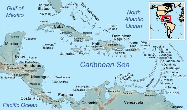
The West Indies is a region of the North Atlantic Ocean in the Caribbean, that includes the island nations and surrounding waters of three major archipelagoes: the Greater Antilles, the Lesser Antilles and the Lucayan Archipelago.[1] The term may also be synonymous with the term Caribbean Basin. The region is generally defined as the area running from Florida westward along the Gulf coast, then south along the Mexican coast through Central America and then eastward across the northern coast of South America. Bermuda is also included within the region even though it is in the west-central Atlantic, due to its common cultural history created by European colonization of the region, and in most of the region by the presence of a significant group of African descent.
After the first of the voyages of Christopher Columbus to the Americas, Europeans began to use the term West Indies to distinguish the region from the East Indies of South Asia and Southeast Asia.
History

In the late sixteenth century, French, English and Dutch merchants and privateers began their operations in the Caribbean Sea, attacking Spanish and Portuguese shipping and coastal areas. They often took refuge and refitted their ships in the areas the Spanish could not conquer, including the islands of the Lesser Antilles, the northern coast of South America including the mouth of the Orinoco, and the Atlantic Coast of Central America. In the Lesser Antilles they managed to establish a foothold following the colonization of St Kitts in 1624 and Barbados in 1626, and when the Sugar Revolution took off in the mid-seventeenth century, they brought in thousands of African slaves to work the fields and mills. These African slaves wrought a demographic revolution, replacing or joining with either the indigenous Caribs or the European settlers who were there as indentured servants.
The struggle between the northern Europeans and the Spanish spread southward in the mid to late seventeenth century, as English, Dutch, French and Spanish colonists, and in many cases their slaves from Africa first entered and then occupied the coast of The Guianas (which fell to the French, English and Dutch) and the Orinoco valley, which fell to the Spanish. The Dutch, allied with the Caribs of the Orinoco would eventually carry the struggles deep into South America, first along the Orinoco and then along the northern reaches of the Amazon.
Since no European country had occupied much of Central America, gradually the English of Jamaica established alliances with the Miskito Kingdom of modern-day Nicaragua and Honduras, and then began logging on the coast of modern-day Belize. These interconnected commercial and diplomatic relations made up the Western Caribbean Zone which was in place in the early eighteenth century. In the Miskito Kingdom, the rise to power of the Miskito-Zambos, who originated in the survivors of a rebellion aboard a slave ship in the 1640s and the introduction of African slaves by British settlers within the Miskito area and in Belize British Honduras also transformed this area into one with a high percentage of persons of African descent as was found in most of the rest of the Caribbean.
From the 17th through the 19th century, the European colonial territories of the West Indies were the French West Indies, British West Indies, the Danish West Indies, the Netherlands Antilles (Dutch West Indies), and the Spanish West Indies.
In 1916, Denmark sold the Danish West Indies to the United States for US$25 million in gold, per the Treaty of the Danish West Indies. The Danish West Indies became an insular area of the US, called the United States Virgin Islands.
Between 1958 and 1962, the United Kingdom re-organised all their West Indies island territories (except the British Virgin Islands and the Bahamas) into the West Indies Federation. They hoped that the Federation would coalesce into a single, independent nation. However, the Federation had limited powers, numerous practical problems, and a lack of popular support; consequently, it was dissolved by the British in 1963, with nine provinces becoming independent sovereign states and four becoming British Overseas Territories.
West Indies or West India was the namesake of several companies of the 17th and 18th centuries, including the Danish West India Company, the Dutch West India Company, the French West India Company, and the Swedish West India Company.
West Indian is the official term used by the U.S. government to refer to people of the West Indies[2]
Use of the term

Tulane University professor Rosanne Adderly says "[T]he phrase 'West Indies' distinguished the territories encountered by Columbus and claimed by Spain from discovery claims by other powers in [Asia's] 'East Indies'. … The term 'West Indies' was eventually used by all European nations to describe their own acquired territories in the Americas. … considering British Caribbean colonies collectively as the 'West Indies' had its greatest political importance in the 1950s with the movement to create a federation of those colonies that could ultimately become an independent nation... Despite the collapse of the Federation [in the early 1960s]… the West Indies continues to field a joint cricket team for international competition."[3]
The West Indies cricket team includes participants from Guyana, which is geographically located in South America.
Countries and Territories by Archipelago
Greater Antilles
Lesser Antilles
-
 Anguilla (United Kingdom)
 -
 Antigua and Barbuda
 -
 Aruba (Netherlands)
 -
 Barbados
 -
 Bonaire (Netherlands)
 -
 British Virgin Islands (United Kingdom)
 -
 Curaçao (Netherlands)
 -
 Dominica
 -
 Grenada
 -
.svg.png) Guadeloupe (France)
Guadeloupe (France) -
 Martinique (France)
 -
 Montserrat (United Kingdom)
 -
 Nueva Esparta (Venezuela)
 -
 Saba (Netherlands)
 -
.svg.png) Saint Barthélemy (France)
Saint Barthélemy (France) -
 Saint Kitts and Nevis
 -
 Saint Lucia
 -
 Saint-Martin (France)
 -
 Saint Vincent and the Grenadines
 -
 Sint Eustatius (Netherlands)
 -
 Sint Maarten (Netherlands)
 -
 Trinidad and Tobago
 -
 United States Virgin Islands (United States)
 -
 Federal Dependencies of Venezuela (Venezuela)
Lucayan Archipelago
-
 Bahamas
 -
 Turks and Caicos Islands (United Kingdom)
See also
- Caribbean Basin Initiative
- Caribbean Basin Trade Partnership Act
- History of the Caribbean
- History of the British West Indies
- Spanish colonization of the Americas
- West Indian
References
- ↑ Caldecott, Alfred (1898). The Church in the West Indies. London: Frank Cass and Co. p. 11. Retrieved 12 December 2013.
- ↑ "Info Please U.S. Social Statistics". Retrieved 1 October 2015.
- ↑ Rosanne Adderly, "West Indies," in Encyclopedia of Contemporary Latin American and Caribbean Cultures, Volume 1: A-D (London and New York: Routledge, 2000): 1584.
Further reading
| Wikimedia Commons has media related to Subdivisions of the Caribbean. |
- Cromwell, Jesse. "More than Slaves and Sugar: Recent Historiography of the Trans-imperial Caribbean and Its Sinew Populations." History Compass (2014) 12#10 pp 770–783.
- Higman, Barry W. A Concise History of the Caribbean. (2011)
- Martin, Tony, Caribbean History: From Pre-colonial Origins to the Present (2011)
Coordinates: 21°59′00″N 79°02′00″W / 21.9833°N 79.0333°W