Volhynia
| Volhynia (Волинь) | ||
| Historical Region | ||
 Lubart's Castle (Lutsk) was the seat of the medieval princes of Volhynia. | ||
|
||
| Countries | Ukraine, Poland, Belarus | |
|---|---|---|
| Regions | Western Ukraine, Eastern Poland | |
| Parts | Volyn Oblast, Rivne Oblast, Zhytomyr Oblast, Ternopil Oblast, Khmelnytskyi Oblast, Lublin Voivodeship, Brest Region | |
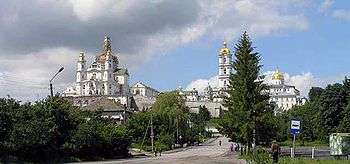
| Landmark | Pochayiv Lavra | |
| Rivers | Horyn River, Styr River, Prypiat River, Western Bug River | |
| Highest point | Povcha Upland | |
| - elevation | 361 m (1,184 ft) | |
| Lowest point | Polesia | |
| - elevation | 130 m (427 ft) | |
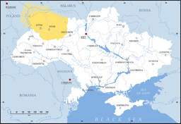 Volhynia (yellow) in modern Ukraine | ||
Volhynia, Volynia, or Volyn (Ukrainian: Волинь, Volýn′, Russian: Волы́нь, Volyn′; Polish: Wołyń, Lithuanian: Voluinė or Volynė; Czech: Volyň, Hungarian: Volhinia, German: Wolhynien or Wolynien (Volhynian German: Wolhinien or Wolinien), Yiddish: Volin װאָלין) is a historic region in Central and Eastern Europe straddling Poland, Ukraine, and Belarus. The alternate name for the region is Lodomeria after the city of Volodymyr-Volynsky (Vo-Lodymer), which once was a political capital of the medieval Volhynian Principality. It has changed hands numerous times throughout history and been divided among competing powers. Since the fall of the Soviet Union in 1991, it has been part of the independent nation of Ukraine.
Location and origin


Geographically it is located in the Volhynian-Podolian Upland section of the vast East European Plain, between the rivers Prypyat and Western Bug. Relative to other historical regions, it is northeast of Galicia, east of Lesser Poland, and northwest of Podolia. The borders of the region are not clearly defined, and it is often considered to overlap a number of other regions, among which are Polesia and Podlasie.
Territories of historical Volhynia are now part of the Volyn, Rivne, and parts of Zhytomyr, Ternopil and Khmelnytskyi Oblasts of Ukraine, as well as parts of Poland (see Chełm). Major cities include Lutsk, Rivne, Kovel, Volodymyr-Volynskyi, Kremenets (Ternopil Oblast), and Starokostiantyniv (Khmelnytskyi Oblast). Before the World War II, many Jewish shtetls (villages), such as Trochenbrod and Lozisht, were an integral part of the region.[1] At one time all of Volhynia was part of the Pale of Settlement designated by Imperial Russia on its southwesternmost border.[2]
According to some historians, the region is named for the former city of Volyn or Velyn, said to have been located on the Southern Bug River,[3] whose name may come from the Proto-Slavic root *vol/vel- 'wet.' In other versions, the city was located over 20 km (12 mi) to the west of Volodymyr-Volynskyi near the mouth of Huczwa River (pl:Huczwa), a tributary of the Western Bug. The land was mentioned in works of the Arabian scholar Al-Masudi who denoted the local tribe as "people of Valin". The first records can be traced to the Ruthenian chronicles, such as the Primary Chronicle, which mentions tribes of the Dulebe, Buzhan, and Volhynian peoples.
History
The ancient city of Halych first appears in recorded history as being taken over in 981 by Vladimir the Great of the Kievan Rus. Volhynia's early history coincides with that of the duchies or principalities of Halych and Volhynia. These two successor states of the Kievan Rus formed Halych-Volhynia between the 12th and the 14th centuries.


After the disintegration of the Grand Duchy of Halych-Volhynia circa 1340, the Kingdom of Poland and the Grand Duchy of Lithuania divided the region between them, Poland taking Western Volhynia and Lithuania taking Eastern Volhynia (1352–1366). After 1569 Volhynia formed a province of the Polish-Lithuanian Commonwealth. During this period many Poles and Jews settled in the area. The Roman and Greek Catholic churches became established in the province. Many Orthodox churches joined the latter organization in order to benefit from a more attractive legal status. Records of the first agricultural colonies of Mennonites date from 1783.
After the Third partition of the Polish-Lithuanian Commonwealth in 1795, Volhynia was annexed as the Volhynian Governorate of the Russian Empire. It covered an area of 71,852.7 square kilometers. This annexation greatly changed the religious make-up of the area, as the Ukrainian Greek Catholic Church was forcibly liquidated by the Russian government; all of its buildings were transferred to the ownership and control of the Russian Orthodox Church. Many Roman Catholic church buildings were also given to the Russian Church, and the Roman Catholic Diocese of Lutsk was suppressed on orders of Empress Catherine II.
In 1897, the population amounted to 2,989,482 people (41.7 per square kilometer). It consisted of 73.7 percent East Slavs (predominantly Ukrainians), 13.2 percent Jews, 6.2 percent Poles, and 5.7 percent Germans.[4] Most of the German settlers had immigrated from Congress Poland. A small number of Czech settlers also had arrived. Although economically the area was developing rather quickly, upon the eve of the First World War it was still the most rural province in Western Russia.
World War I and the German Settlements in Volhynia
When World War I began in1914, there were 1,621,000 Germans living in the Russian Empire. The number of German colonists living in the settlements of Russian Volhynia totaled 150,000. The declaration of war against the German empire came as a great shock to all German Russians. Despite repeated declarations of unconditional loyalty to Russia and its emperor, the Germans increasingly became objects of suspicion and even hate. They were a scapegoat for Russian military defeats, economic problems and administrative ineptness in pursuing the war.
The German Russians nevertheless joined the army willingly and were prepared to fight against their former homeland. Over 250,000 German colonists served in the Russian army during the war. Most German Russians, however, were not sent to the Western Front to fight against the German and Austrian armies, but to the Turkish fighting front in the Caucasus. Those who initially served in the West were subsequently removed and also sent to the Caucasus.
As Russia’s war losses increased so did anti-German hysteria. They were made responsible for the disastrous course of the war and were accused of being spies and saboteurs betraying Russia. Anti-German measures reached a nadir with the government’s so-called Liquidation Laws, of February 1915, to expropriate German properties in the Western border provinces, especially in Volhynia. Compensation was envisaged in the form of 25 year government obligations. The laws were not enforced immediately due to the concern over economic disruption. The presence of the decrees, however, caused great anxiety in many German villages, particularly in the province of Volhynia, resulting in panic sales or neglect of the land expected to be expropriated at any moment.
Grand Duke Nicolas (who, at the time, was still commander in chief of the Western forces), after suffering serious defeats at the hands of the German army, decided to implement the decrees for the German Russians living under his army’s control, principally in the Volhynia province. The lands were to be expropriated, and the owners deported to Siberia. The land was to be given to Russian war veterans once the war was over. In July, 1915, and with no prior warning, 150,000 German settlers from Volhynia were arrested and shipped to internal exile in Siberia and Central Asia. (Some sources indicate that the number of deportees reached 200,000). Ukrainian peasants then took over their lands. The mortality rate from these deportations is estimated to have been 63,000 to 100,000, that is from 30% to 50%, but exact figures are impossible to determine.
The March 1917 revolution and the Czar’s abdication later in March of that year put a stop to further confiscation measures against German colonists in Russia; they were never carried out. The liquidation decrees were suspended by the Provisional Government . The new government issued a declaration of human rights whereby all national minorities, including the Germans, were given full equality. For the Volhynian Germans, however, these actions came too late, as the greater part of the population had been deported. Although they were now permitted to return and attempt to reclaim their land, it is estimated that only one-half of their number did so. Many found their houses destroyed and their farms occupied by strangers.
At the end of the First World War, there was an attempt to form the Ukrainian National Autonomy. The territory of Volhynia was split in half by a frontline just west of the city of Lutsk. Due to an invasion of Bolsheviks, the government of Ukraine was forced to retreat to Volhynia after the sack of Kiev. Military aid from the Central Powers set peace in the region and brought some degree of stability. Until the end of the war, the area saw a revival of Ukrainian culture after years of Russian oppression and the denial of Ukrainian traditions. After German troops were withdrawn, the whole region was engulfed by a new wave of military actions by Poles and Russians competing for control of the territory. Ukraine was forced to fight on three fronts - Bolsheviks, Poles, and a Volunteer Army of Imperial Russia.
Post World War I
In 1921, after the end of the Polish-Soviet war, the treaty known as the Peace of Riga divided the Volhynian Governorate between Poland and the Soviet Union. Poland took the larger part and established a Volhynian Voivodeship. Most of eastern Volhynian Governorate became part of the Ukrainian SSR, eventually splitting into smaller districts. During that period, a number of various national districts were formed within the Soviet Ukraine as part of cultural liberalization. The policies of Polonization in Poland led to formations of various resistance movements in West Ukraine and West Belarus, including Volhynia.
From 1935 to 1938 as part of the dekulakization, an effort to suppress peasant farmers, the government of the Soviet Union deported numerous nationals from Volhynia to Siberia and central Asia. These included the Poles of Eastern Volhynia (see Population transfer in the Soviet Union).
Following the signing of the Molotov-Ribbentrop Pact in 1939 and the subsequent invasion and division of Polish territories between the Reich and the USSR, the Polish part of Volhynia was occupied by the Soviet Union. In the course of the Nazi-Soviet population transfers which followed this German-Soviet reconciliation, most of the German minority population of Volhynia were transferred to Polish areas annexed by Nazi Germany. Following the mass deportations and arrests carried out by the NKVD and after the subsequent German repressions (e.g., deportation to the Reich to forced labor, arrests, detention in camps, and mass executions), by 1943 Poles constituted only 10−12 % of the entire population of Volhynia. During the German invasion, around 40,000–60,000 Polish people in Volhynia were massacred by the Ukrainian Insurgent Army. The number of Ukrainian victims of Polish retaliatory attacks until the spring of 1945 is estimated at approx. 2,000−3,000 in Volhynia.[6] Ethnic Germans in Volhynia were expelled from these areas in 1945 following the end of the war, because Nazi Germany had used ethnic Germans in eastern Europe as an excuse to invade those areas.
Volhynia was annexed to Soviet Ukraine after the end of World War II. Most of the remaining ethnic Polish population were expelled to Poland in 1945. Since the dissolution of the Soviet Union in the 1990s, Volhynia has been an integral part of Ukraine.
Important relics
Notable residents
- Moisei Kas’ianik, weightlifter
- Malbim, rabbi
- Hayim Nahman Bialik, literary figure
See also
- Kingdom of Galicia–Volhynia
- Galicia (Eastern Europe)
- Massacres of Poles in Volhynia and Eastern Galicia
- Historiography of the Volyn tragedy
- Polish Autonomous District
- Kresy Wschodnie
References
- ↑ Michael Jones (2000). The New Cambridge Medieval History. Cambridge University Press. p. 770. ISBN 0-521-36290-3.
- ↑ Oreck, Alden. "Jewish Virtual Library-The Pale of Settlement". Jewish Virtual Library. Jewish Virtual Library. Retrieved July 10, 2013.
- ↑ E.M. Pospelov, Geograficheskie nazvaniya mira (Moscow, 1998), p. 104.
- ↑ Meyers Konversations-Lexikon. 6th edition, Vol. 20, Leipzig and Vienna" 1909, pp. 744-745.
- ↑ Merten, Ulrich (2015). Voices from the Gulag: the Oppression of the German Minority in the Soviet Union. Lincoln Nebraska: American Historical Society. pp. 77, 78, 79, 80, 82. ISBN 978-0-692-60337-6.
- ↑ http://www.volhyniamassacre.eu/history/history
Literature
- Jan Potocki Histoire anciènne du gouvernement de Volhynie : pour servir de suite à l'histoire primitive des peuples de la Russie, Sankt Petersbourg, 1805
- Andriyashev Alexander (1887) (in Russian) Essay of the History of Volyn land (Очерк истории Волынской земли) at Runivers.ru in Djvu and PDF formats
- Kathryn Ciancia, "Borderland Modernities: Poles, Jews, and Urban Spaces in Interwar Volhynia," Journal of Modern History, forthcoming 2016.
- Ulrich Merten, Voices from the Gulag: Oppression of the German Minority in the Soviet Union, (American Historical Society of Germans from Russia, Lincoln, Nebraska, 2015) ISBN 978-0-692-60337-6
- Central European Superpower, Henryk Litwin, BUM Magazine, October 2016.
External links
| Look up Volyn in Wiktionary, the free dictionary. |
| Wikimedia Commons has media related to Volhynia. |
- The Journey to Trochenbrod and Lozisht aug 2006
- Imperial Russian Volhynia District Map
- Swiss-Volhynian Mennonites
- Germans in Volhynia - English
- Germans in Volhynia - Another English site
- Germans in Volhynia - German
- Volhynia-Galicia (Polish)
- American Historical Society of Germans from Russia, Lincoln, Nebraska
Coordinates: 50°44′42.0″N 25°21′13.7″E / 50.745000°N 25.353806°E