Lubbock County, Texas
| Lubbock County, Texas | |
|---|---|
|
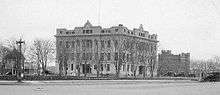
The current Lubbock County Courthouse | |
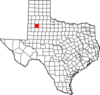 Location in the U.S. state of Texas | |
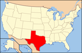 Texas's location in the U.S. | |
| Founded | 1891 |
| Named for | Thomas Saltus Lubbock |
| Seat | Lubbock |
| Largest city | Lubbock |
| Area | |
| • Total | 901 sq mi (2,334 km2) |
| • Land | 896 sq mi (2,321 km2) |
| • Water | 5.1 sq mi (13 km2), 0.6% |
| Population (est.) | |
| • (2015) | 299,453 |
| • Density | 332.36/sq mi (128/km²) |
| Congressional district | 19th |
| Time zone | Central: UTC-6/-5 |
| Website |
www |

Lubbock County is a county located in the U.S. state of Texas. As of the 2010 census, the population was 278,831.[1] Its county seat is Lubbock.[2] The county was created in 1876 and organized in 1891.[3] It is named for Thomas Saltus Lubbock,[4] a Confederate colonel and Texas Ranger (some sources give his first name as Thompson).
Lubbock County, along with Crosby County, and Lynn County, is part of the Lubbock Metropolitan Statistical Area (MSA). The Lubbock MSA and Levelland Micropolitan Statistical Area (µSA), encompassing only Hockley County, form the larger Lubbock–Levelland Combined Statistical Area (CSA).
Geography
According to the U.S. Census Bureau, the county has a total area of 901 square miles (2,330 km2), of which 896 square miles (2,320 km2) is land and 5.1 square miles (13 km2) (0.6%) is water.[5]
Major highways
 Interstate 27
 U.S. Highway 62/U.S. Highway 82
 U.S. Highway 84
 U.S. Highway 87
 State Highway 114
 Loop 289
Adjacent counties
- Hale County (north)
- Crosby County (east)
- Lynn County (south)
- Hockley County (west)
- Lamb County (northwest)
- Terry County (southwest)
- Garza County (southeast)
Demographics
| Historical population | |||
|---|---|---|---|
| Census | Pop. | %± | |
| 1880 | 25 | — | |
| 1890 | 33 | 32.0% | |
| 1900 | 293 | 787.9% | |
| 1910 | 3,624 | 1,136.9% | |
| 1920 | 11,096 | 206.2% | |
| 1930 | 39,104 | 252.4% | |
| 1940 | 51,782 | 32.4% | |
| 1950 | 101,048 | 95.1% | |
| 1960 | 156,271 | 54.7% | |
| 1970 | 179,295 | 14.7% | |
| 1980 | 211,651 | 18.0% | |
| 1990 | 222,636 | 5.2% | |
| 2000 | 242,628 | 9.0% | |
| 2010 | 278,831 | 14.9% | |
| Est. 2015 | 299,453 | [6] | 7.4% |
| U.S. Decennial Census[7] 1850–2010[8] 2010–2014[1] | |||
As of the census[9] of 2000, there were 242,628 people, 92,516 households, and 60,135 families residing in the county. The population density was 270 people per square mile (104/km²). There were 100,595 housing units at an average density of 112 per square mile (43/km²). The racial makeup of the county was 74.30% White, 7.67% Black or African American, 0.59% Native American, 1.31% Asian, 0.04% Pacific Islander, 14.15% from other races, and 1.96% from two or more races. 27.45% of the population were Hispanic or Latino of any race.
There were 92,516 households out of which 31.70% had children under the age of 18 living with them, 48.20% were married couples living together, 12.60% had a female householder with no husband present, and 35.00% were non-families. 26.90% of all households were made up of individuals and 7.90% had someone living alone who was 65 years of age or older. The average household size was 2.52 and the average family size was 3.10.
In the county, the population was spread out with 25.70% under the age of 18, 16.30% from 18 to 24, 27.90% from 25 to 44, 19.20% from 45 to 64, and 11.00% who were 65 years of age or older. The median age was 30 years. For every 100 females there were 95.80 males. For every 100 females age 18 and over, there were 92.60 males.
The median income for a household in the county was $32,198, and the median income for a family was $41,067. Males had a median income of $29,961 versus $21,591 for females. The per capita income for the county was $17,323. About 12.00% of families and 17.80% of the population were below the poverty line, including 21.60% of those under age 18 and 10.70% of those age 65 or over.
Politics
| Year | Democratic | Republican |
|---|---|---|
| 2012 | 28.8% 26,088 | 69.7% 63,133 |
| 2008 | 31.3% 30,486 | 68.4% 66,304 |
| 2004 | 24.1% 22,472 | 75.3% 70,135 |
| 2000 | 24.3% 18,469 | 73.8% 56,054 |
| 1996 | 30.6% 22,786 | 63.5% 47,304 |
| 1992 | 26.8% 22,240 | 59.0% 48,847 |
| 1988 | 30.3% 22,202 | 69.3% 50,760 |
| 1984 | 24.7% 18,793 | 75.0% 57,151 |
| 1980 | 27.6% 18,732 | 68.8% 46,711 |
| 1976 | 38.9% 24,797 | 60.4% 38,478 |
| 1972 | 25.9% 15,353 | 73.5% 43,564 |
| 1968 | 30.8% 15,430 | 51.1% 25,646 |
| 1964 | 55.9% 22,057 | 41.1% 17,372 |
Communities
- Abernathy (mostly in Hale County)
- Acuff
- Becton
- Buffalo Springs
- Estacado (partly in Crosby County)
- Heckville
- Idalou
- Lubbock (county seat)
- New Deal
- Posey
- Ransom Canyon
- Reese Center
- Roosevelt
- Shallowater
- Slaton
- Slide
- Wolfforth
- Woodrow
See also
- Caprock Escarpment
- List of museums in West Texas
- Llano Estacado
- National Register of Historic Places listings in Lubbock County, Texas
- West Texas
- Yellow House Canyon
- Yellow House Draw
References
- 1 2 "State & County QuickFacts". United States Census Bureau. Retrieved December 19, 2013.
- ↑ "Find a County". National Association of Counties. Retrieved 2011-06-07.
- ↑ "Texas: Individual County Chronologies". Texas Atlas of Historical County Boundaries. The Newberry Library. 2008. Retrieved May 25, 2015.
- ↑ Gannett, Henry (1905). The Origin of Certain Place Names in the United States. U.S. Government Printing Office. p. 191.
- ↑ "2010 Census Gazetteer Files". United States Census Bureau. August 22, 2012. Retrieved May 3, 2015.
- ↑ "County Totals Dataset: Population, Population Change and Estimated Components of Population Change: April 1, 2010 to July 1, 2015". Retrieved July 2, 2016.
- ↑ "U.S. Decennial Census". United States Census Bureau. Retrieved May 3, 2015.
- ↑ "Texas Almanac: Population History of Counties from 1850–2010" (PDF). Texas Almanac. Retrieved May 3, 2015.
- ↑ "American FactFinder". United States Census Bureau. Retrieved 2011-05-14.
External links
- Lubbock County government’s website
- Lubbock County from the Handbook of Texas Online
- Texas Tech University
- Lubbock County Profile from the Texas Association of Counties
 |
Hale County | | ||
| Hockley County | |
Crosby County | ||
| ||||
| | ||||
| Lynn County |
Municipalities and communities of Lubbock County, Texas, United States | ||
|---|---|---|
| Cities | | |
| Towns | ||
| Village | ||
| Unincorporated communities | ||
| Ghost town | ||
| Footnotes | ‡This populated place also has portions in an adjacent county or counties | |

Coordinates: 33°37′N 101°49′W / 33.61°N 101.82°W