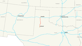
Interstate 27
| ||||
|---|---|---|---|---|
| Marshall Formby Memorial Highway | ||||
 | ||||
| Route information | ||||
| Maintained by TxDOT | ||||
| Length: | 124.13 mi[1] (199.77 km) | |||
| Existed: | 1969[1] – present | |||
| Major junctions | ||||
| South end: |
| |||
|
| ||||
| North end: |
| |||
| Highway system | ||||
| ||||

Interstate 27 (I-27) is an Interstate Highway, entirely in the U.S. state of Texas, running north from Lubbock to Interstate 40 in Amarillo. These two cities are the only control cities on I-27;[2] other cities and towns served by I-27 include (from south to north) New Deal, Abernathy, Hale Center, Plainview, Kress, Tulia, Happy, and Canyon. In Amarillo, I-27 is commonly known as the Canyon Expressway (or Canyon E-Way), although it is also called Canyon Drive on its access roads. I-27 was officially designated the Marshall Formby Memorial Highway after former attorney and Texas State Senator Marshall Formby in 2005.[1] The entire length of I-27 replaced U.S. Route 87 for through traffic.
Route description

I-27 parallels the BNSF Railway's Plainview Subdivision, which splits from its Chicago-Southern California Transcon line at Canyon and runs south to Lubbock. A large amount of the alignment is on former US 87, but several portions through built-up areas have been bypassed, as well as two longer areas where US 87 still follows the old road.[3]
The Interstate begins at a point along the four-lane US 87 freeway south of downtown Lubbock. Mile 0 is posted near 77th Street,[4] about five blocks south of Loop 289. Exit numbering begins just to the south, with exit 1 at the 82nd Street interchange; the freeway becomes six lanes at its north end. The Loop 289 interchange is a cloverleaf between the one-way frontage roads of each highway, and with direct ramps from I-27 south to Loop 289 west (exit 1A) and Loop 289 east to I-27 north. U.S. Highway 84 (Avenue Q and Slaton Highway) crosses I-27 at a split diamond interchange, with an extra approach from the northeast carrying Avenue A (former U.S. Highway 87 Business) into the junction. Exit 1B connects I-27 south to US 84 and the Loop 289 frontage roads, while all traffic from US 87 north to US 84, US 87 Business, or Loop 289 must use exit 1 for 82nd Street.[5]
The six-lane cross section that began at exit 1 remains through Lubbock. Major junctions in that city include U.S. Highway 62/State Highway 114 (19th Street, exit 3) and U.S. Highway 82 (Marsha Sharp Freeway, exit 4). Between these two interchanges, the frontage roads temporarily end as I-27 crosses over a rail line. Spur 326 (Avenue Q) merges with I-27 at exit 6A, and exit 6B is a split diamond with Loop 289. The outer lanes leave at Farm to Market Road 2641 (Regis Street, exit 8), reducing I-27 to two lanes in each direction as it passes Lubbock Preston Smith International Airport and leaves the city.[5]

I-27 crosses over the Plainview Sub for the first time north of Farm to Market Road 1294 (Drew Street, exit 11), and another short gap exists in the frontage roads there. North of the overpass, the frontage roads are two-way; I-27 then passes through New Deal, bypassing the central part of the town to the west. Old US 87 between exits 13 and 15 is now Loop 461; at exit 15, I-27 begins to parallel the rail line, just to its west. Along this part of the highway, and other similar portions, slip ramps still connect the main lanes with the frontage roads, but intersecting roads pass over all four roadways and the railroad on a long bridge; a pair of two-way roadways connects the frontage roads to the crossroad, with the one on the east crossing the railroad at-grade.[5]
As it approaches Abernathy, I-27 curves west away from the Plainview Sub. The old main road through the city, between exits 20 and 22, is now Loop 369; I-27 passes through 1.5 blocks to the east. Despite I-27's location north of Abernathy, 1/2 mile (1 km) west of the rail line, all interchanges between Abernathy and Hale Center, except the one at Farm to Market Road (exit 24), use the same configuration where the intersecting road crosses over all roadways. Approaching Hale Center, I-27 curves northeast as it splits from Farm to Market Road 1424 (exit 36) at a simple diamond interchange. The freeway passes through the city one block east of the old road, now I-27 Business, which is accessed at exits 36 and 38. As it leaves Hale Center, I-27 turns to the northeast, following the northwest side of the rail line.[5]
The next two interchanges along the railroad between Hale Center and Plainview use the same style, in which the crossroad goes over everything. I-27 Business splits at exit 45, a modified Y interchange, to pass through Plainview, and I-27 travels west of that city on a bypass. The two outer interchanges on this bypass, Farm to Market Road 3466 (exit 48) and Quincy Street (exit 51), are handled in the same way as the interchanges along the railroad, but the other two, U.S. Highway 70 (exit 49) and State Highway 194 (exit 50), are standard diamonds. Between exits 49 and 50 is another overpass over the frontage roads - 24th Street — with no separate slip ramps. I-27 Business ends at a trumpet interchange (exit 53) north of Plainview, where I-27 again begins to parallel the Plainview Sub to the west. Both interchanges between this one and the first split with US 87 (exit 61), a modified Y south of Kress, continue the pattern with the crossroad bridging over everything.[5]
After it leaves US 87, I-27 is no longer next to the rail line, but it continues to handle interchanges as it does alongside the line, except at State Highway 86 (exit 74), a standard diamond that serves Tulia. US 87 rejoins the freeway at a modified diamond (exit 77) north of Tulia, at which I-27 crosses to the east side of the Plainview Sub before paralleling it to that side. After several of the typical interchanges adjacent to the railroad, US 87 splits again at a modified Y (exit 88) south of Happy. Except for the northernmost one, all of the interchanges on the bypass of Happy and Canyon are diamonds; there is a break in the frontage road north of Farm to Market Road 3331 (exit 108), where I-27 crosses the Prairie Dog Town Fork Red River. Exits 109 (Buffalo Stadium Road) and 110 (US 87 south, US 60 west) are integrated, with some access to one road provided via the other.[5]
I-27 is overlapped by US 60 and US 87 from exit 110 north of Canyon to the end of the Interstate in Amarillo; here the frontage roads are one-way. Several near the south end are handled by bridging the intersecting road over all roadways, but, once I-27 crosses Loop 335 (exit 116), almost all interchanges are diamonds. At exit 119A, which marks the south end of the six-lane cross section in Amarillo, Hillside Road passes under both the main lanes and the frontage roads, with two ramps providing partial access. Other connections with Hillside Road are made via Western Street (exit 119B), which crosses the frontage roads at grade. The end of I-27 at Interstate 40 (exit 123B) is a fully directional turbine interchange; U.S. Highway 287 also passes through, using I-40 to the east and US 60/US 87 to the north. Four lanes continue beyond I-40, and are joined by several from the I-40 ramps, making the northernmost portion of the Canyon Expressway five lanes in each direction. Several blocks beyond I-40, the highway ends at a split into two one-way pairs. Northbound traffic feeds onto Fillmore Street (US 87 north) and Buchanan Street (US 60 east and US 287 north), while southbound traffic approaches on Taylor Street (US 287 south) and Pierce Street (US 60 west and US 87 south). The rightmost of the five northbound lanes is barrier-separated from the rest, forcing traffic exiting I-40 west onto Buchanan Street. Through the I-40 interchange and the split, the frontage roads are discontinuous.[5]
History
The roadway between Lubbock and Amarillo was part of the Puget Sound to Gulf Highway (State Highway 9), one of the original state highways defined in 1917.[6] In 1926, it became part of U.S. Highway 385,[7] which was absorbed into U.S. Highway 87 in 1935.[8] The SH 9 overlap was dropped in the 1939 renumbering.[9][10] Paving began in 1929 near Plainview,[11] and was almost complete by 1940, with only about 8 miles (13 km) south of Canyon still bituminous surfaced[12] until later that decade.[13] The Canyon Expressway, a freeway upgrade of US 87 (also US 60 there) between Canyon and Amarillo, was built in the late 1950s and early 1960s.[11] This highway, with a design speed of 45 miles per hour (70 km/h), included frontage roads along its entire length,[14] and ended in each city with a wye junction: the split of US 60 and US 87 in Canyon, and a split between the two one-way pairs of Taylor and Fillmore Streets and Pierce and Buchanan Streets in Amarillo. The Dumas Expressway, a freeway upgrade of US 87 north from Amarillo, opened several years later, feeding into the same one-way pairs.[15]
Four-laning of US 87 from Canyon to Lubbock was completed in the late 1960s, with the last section to be widened lying between Abernathy and Lubbock. While this was built as a surface divided highway south of Canyon,[16][17][18] short sections of freeway were built through New Deal, Abernathy, and Hale Center, and interchanges were built at U.S. Highway 70 and State Highway 194 on the new bypass of Plainview[19] and at State Highway 86 (towards the west) south of Tulia.[14][15] The original two-lane road, where bypassed, became Loop 461 (New Deal, 1968, marked as US 87 Business),[20] Loop 369 (Abernathy, 1962),[21] a local street (Hale Center), and Loop 445 (Plainview, 1967, marked as US 87 Business).[22]
Interstate 27 was not part of the original Interstate Highway System chosen in the 1950s; the spur from I-40 to Lubbock was authorized with the Federal-Aid Highway Act of 1968, which added 1500 miles (2400 km) to the system.[23] George H. Mahon, member of the U.S. House of Representatives from 1935 to 1979 and chairman of the House Appropriations Committee after 1964, helped secure funding for the road. Texas officially designated the highway in early 1969, originally running from U.S. Highway 62 near downtown Lubbock to I-40 in Amarillo; the definition was extended south through Lubbock to the south side of the loop in early 1976.[1] The existing freeway sections, including the Canyon Expressway, were absorbed into I-27, despite not being built to Interstate standards. New construction began in 1975, from Lubbock north to New Deal, and most of the freeway was completed in the 1980s.[15] Two long sections of US 87 were bypassed: Happy to Canyon on December 5, 1986,[11] and Kress to Tulia soon after;[15] I-27 was complete north of Lubbock by 1988.[24] Most of the Happy-Canyon bypass was built along the two-lane Farm to Market Road 1541, which now ends at exit 103 southeast of Canyon.[25]
The final section of I-27 to be built was through Lubbock, inside Loop 289; this was built in the early 1990s, and completed on September 3, 1992. On that day, a ceremony at the 34th Street overpass opened the road from 19th Street (US 62) to 54th Street,[26] completing Texas's 3200-mile (5100 km) portion of the Interstate Highway System.[27] At its south end, the new I-27 connected to an existing freeway upgrade of US 87, built about 1970[15] to a traffic circle at US 84 (just north of Loop 289).[28] The old route of US 87 through Lubbock became U.S. Highway 87 Business upon completion of I-27.[29] Two business loops of I-27 have been designated: through Plainview (former Loop 445) in early 1991,[30] and through Hale Center (formerly a local street) in 2002.[31]
The completion of I-27, costing a total of $453.4 million, encouraged growth along the highway: towards the north side of Lubbock and the southwest in Amarillo; Canyon has become a suburb of Amarillo. Plainview, the largest city between Lubbock and Amarillo, has the only significant retail cluster outside the two terminal cities, and has attracted several industries. On the other hand, Tulia, once a self-contained community with local businesses, was bypassed by I-27, and residents must now drive elsewhere for most shopping needs.[11]
Future
In 1995, a study of a southern extension of I-27 to I-10[32] found that a full freeway extension would not be economically feasible, instead recommending limited upgrades to the three corridors studied: SH 349 via Midland and Odessa to east of Fort Stockton, US 87 via Big Spring to Sonora or Junction, and US 84 via Sweetwater to Sonora or Junction. Of the three corridors, the Sweetwater route came the closest to warranting a freeway.[33] The Transportation Equity Act for the 21st Century, passed in 1998, designated I-27 as part of the Ports-to-Plains Trade Corridor, a High Priority Corridor from Mexico at Laredo to Denver.[34] This corridor crosses I-20 at Big Spring and Midland (via a split), and I-10 at Sonora.[35] It also forms part of the Great Plains International Trade Corridor, continuing north to Saskatoon, Saskatchewan.[36] The part of the Ports-to-Plains Trade Corridor within Texas was a proposed Trans-Texas Corridor.[37]
Exit list
| County | Location | mi | km | Exit | Destinations | Notes |
|---|---|---|---|---|---|---|
| Lubbock | Lubbock | Continuation | ||||
| 1 | Southern terminus | |||||
| 1A | 50th Street | Signed as exit 1C southbound | ||||
| 2 | 34th Street, B. Holly Ave | |||||
| 3 | ||||||
| 3A | 13th Street, Broadway | Northbound exit and southbound entrance | ||||
| 4 | ||||||
| 5 | Buddy Holly Avenue, Municipal Drive | Southbound exit and northbound entrance | ||||
| 6A | Southbound exit and northbound entrance | |||||
| 6B | Signed as exit 6 northbound | |||||
| 7 | Yucca Lane | |||||
| 8 | ||||||
| 9 | ||||||
| 10 | Keuka Street | Signed as exits 10A (east) and 10B (west) | ||||
| 11 | Signed as exits 11A (east) and 11B (west) | |||||
| | 12 | County Road 58 | Northbound exit and southbound entrance | |||
| New Deal | 13 | |||||
| 14 | ||||||
| 15 | Southbound exit and northbound entrance | |||||
| | 17 | County Road 53 | ||||
| | 20 | Northbound exit and southbound entrance | ||||
| Hale | Abernathy | 21 | ||||
| 22 | Southbound exit and northbound entrance | |||||
| | 24 | |||||
| | 27 | County Road | ||||
| | 31 | South end of FM 37 overlap | ||||
| | 32 | North end of FM 37 overlap | ||||
| | 36 | |||||
| Hale Center | 37 | |||||
| | 38 | Main Street (I-27 Bus. south) | Southbound exit and northbound entrance | |||
| | 41 | County Road | ||||
| | 43 | |||||
| | 45 | |||||
| Plainview | 48 | Northbound exit and southbound entrance | ||||
| 49 | ||||||
| 50 | ||||||
| 51 | Quincy Street | |||||
| | 53 | |||||
| | 54 | |||||
| | 56 | |||||
| Swisher | | 61 | North end of US 87 overlap | |||
| | 63 | |||||
| | 68 | |||||
| Tulia | 74 | |||||
| 75 | Northwest 6th Street | |||||
| | 77 | South end of US 87 overlap | ||||
| | 82 | |||||
| | 83 | |||||
| | 88 | North end of US 87 overlap; signed as exits 88A (FM 1881) and 88B (US 87 north) northbound | ||||
| Swisher–Randall county line | Happy | 90 | ||||
| Randall | | 92 | Haley Road | |||
| | 94 | |||||
| | 96 | Dowlen Road | ||||
| | 99 | Hungate Road | ||||
| | 103 | |||||
| Canyon | 106 | |||||
| | 108 | |||||
| | 109 | Buffalo Stadium Road | ||||
| | 110 | South end of US 60/US 87 overlap; no northbound exit | ||||
| | 111 | Rockwell Road | ||||
| | 112 | |||||
| | 113 | McCormick Road | ||||
| | 115 | Sundown Lane | ||||
| Amarillo | 116 | |||||
| 117 | Bell Street, Arden Road | |||||
| 119 | Hillside Road, Western Street, 58th Avenue | Signed as exits 119A (Hillside Road west) and 119B (Western Street, 58th Avenue) southbound | ||||
| 120A | Republic Avenue | Southbound exit and northbound entrance | ||||
| 120B | 45th Avenue | Signed as exit 120 northbound | ||||
| 121A | Georgia Street | Signed as exit 121 northbound | ||||
| 121B | Hawthorne Drive, Austin Street | Southbound exit and northbound entrance | ||||
| 122A | Parker Street, Moss Lane | Northbound exit and southbound entrance | ||||
| 122B | ||||||
| 122C | 34th Street, Tyler Street | Southbound exit and northbound entrance | ||||
| Potter | 123A | 26th Avenue | Signed as exit 123 southbound | |||
| 123B | Northern terminus; no exit number southbound; I-40 exit 70 | |||||
| Continuation | ||||||
1.000 mi = 1.609 km; 1.000 km = 0.621 mi
| ||||||
Business routes
Hale Center
| |
|---|---|
| Location: | Hale Center |
| Length: | 1.168 mi[31] (1.880 km) |
| Existed: | 2002[31]–present |
Business Interstate 27-T is a business loop in the U.S. state of Texas. It stretches 1.168 miles (1.880 km) along Main Street through Hale Center, between exits 36 and 38 of I-27. It was bypassed in about 1962,[15] but was turned over to the city until April 5, 2002, when the new business route was authorized.[31] Along the way, it intersects Farm to Market Road 1914 (Cleveland Street).
- Major intersections
The entire route is in Hale Center, Hale County.
| mi[38] | km | Destinations | Notes | ||
|---|---|---|---|---|---|
| 0.0 | 0.0 | ||||
| 0.5 | 0.80 | ||||
| 1.168 | 1.880 | ||||
| 1.000 mi = 1.609 km; 1.000 km = 0.621 mi | |||||
Plainview
| |
|---|---|
| Location: | Plainview |
| Length: | 9.282 mi[30] (14.938 km) |
| Existed: | 1990[30]–present |
Business Interstate 27-U is a 9.3-mile (15.0 km) business loop in Plainview.
References
- 1 2 3 4 Transportation Planning and Programming Division (n.d.). "Interstate Highway No. 27". Highway Designation Files. Texas Department of Transportation. Retrieved January 28, 2013.
- ↑ American Association of State Highway and Transportation Officials, List of Control Cities for Use in Guide Signs on Interstate Highways, 2001
- ↑ Google (2008-02-15). "overview map of I-27" (Map). Google Maps. Google. Retrieved 2008-02-15.
- ↑ Transportation Planning and Programming Division (2014). Texas County Map Book (PDF) (Map) (2014 ed.). 1:120,000. Texas Department of Transportation. p. 125. Retrieved December 23, 2014.
- 1 2 3 4 5 6 7 Google Maps street maps and satellite imagery, accessed August 2007
- ↑ Commerce Journal, Highway Commission Adopts 25 Highways, July 6, 1917
- ↑ Bureau of Public Roads & American Association of State Highway Officials (November 11, 1926). United States System of Highways Adopted for Uniform Marking by the American Association of State Highway Officials (Map). 1:7,000,000. Washington, DC: U.S. Geological Survey. OCLC 32889555. Retrieved November 7, 2013 – via University of North Texas Libraries.
- ↑ Texas Department of Transportation, Highway Designation File: U.S. Highway No. 87
- ↑ H.M. Gousha Company, Official Road Map: Texas (Conoco), 1938 Archived April 9, 2014, at the Wayback Machine.
- ↑ Texas Department of Transportation, Highway Designation File: State Highway No. 9
- 1 2 3 4 Jack Faucett Associates, Inc. of Bethesda, Maryland under contract with the Federal Highway Administration, Economic Development History of Interstate 27 in Texas, accessed August 2007
- ↑ Texas State Highway Department, General Highway Maps: Lubbock, Hale, Swisher, Randall, and Potter Counties, partially revised to February 1, 1940
- ↑ Rand McNally & Company, Texas-Oklahoma-Eastern New Mexico (Sinclair), 1946 Archived April 9, 2014, at the Wayback Machine.
- 1 2 Texas State Highway Department, General Highway Maps: Lubbock, Hale, Swisher, Randall, and Potter Counties, and Amarillo and vicinity, state highways revised to January 1, 1961
- 1 2 3 4 5 6 Federal Highway Administration, National Bridge Inventory, 2006
- ↑ General Drafting Company, Texas (Enco), 1961 Archived April 9, 2014, at the Wayback Machine.
- ↑ H.M. Gousha Company, Texas (Texaco), 1967 Archived April 9, 2014, at the Wayback Machine.
- ↑ H.M. Gousha Company, Texas (Texaco), 1969 Archived August 14, 2007, at the Wayback Machine.
- ↑ U.S. Geological Survey, 15 minute quadrangle of Plainview, Texas, July 1, 1983 (before the bypass was upgraded to freeway standards)
- ↑ Texas Department of Transportation, Highway Designation File: State Highway Loop No. 461
- ↑ Texas Department of Transportation, Highway Designation File: State Highway Loop No. 369 Archived October 8, 2012, at the Wayback Machine.
- ↑ Texas Department of Transportation, Highway Designation File: State Highway Loop No. 445
- ↑ Federal Highway Administration, FHWA By Day: December 13, accessed August 2007
- ↑ Rand McNally, 1988 Road Atlas
- ↑ Texas Department of Transportation, Highway Designation File: Farm to Market Road No. 1541
- ↑ Federal Highway Administration, Previous Interstate Facts of the Day (May 5, 2007), accessed August 2007
- ↑ Texas Department of Transportation, TxDOT History: 2000 to 1971, accessed August 2007
- ↑ U.S. Geological Survey, 7.5 minute quadrangle of southern Lubbock, Texas, July 1, 1975
- ↑ Texas Department of Transportation, Highway Designation File: Business U.S. Highway No. 87-G
- 1 2 3 Transportation Planning and Programming Division (n.d.). "Business Interstate Highway No. 27-U". Highway Designation Files. Texas Department of Transportation. Retrieved November 28, 2014.
- 1 2 3 4 Texas Department of Transportation, Highway Designation File: Business Interstate Highway No. 27-T
- ↑ Austin American-Statesman, Towns to vie for I-27 extension, July 18, 1995
- ↑ San Antonio Express-News, Engineers opt for improving 3 roads, May 14, 1996
- ↑ Ports to Plains study, Frequestly Asked Questions, accessed August 2007
- ↑ Ports to Plains study, Corridor Map, accessed August 2007
- ↑ Ports-to-Plains Trade Corridor Coalition, PTP Partners: Great Plains International Trade Corridor, accessed August 2007 Archived September 16, 2008, at the Wayback Machine.
- ↑ Texas Department of Transportation, Trans-Texas Corridor conceptual map, 2002
- ↑ Google (May 11, 2013). "Directions from I-27 to Cleveland Street" (Map). Google Maps. Google. Retrieved May 11, 2013.
External links
| Wikimedia Commons has media related to Interstate 27. |
| Signed | |||||||||||
|---|---|---|---|---|---|---|---|---|---|---|---|
| Unsigned | |||||||||||
| Lists |
| ||||||||||
Major Interstates highlighted | |||||||||||