Battle of Großbeeren
| Battle of Großbeeren | |||||||
|---|---|---|---|---|---|---|---|
| Part of the War of the Sixth Coalition | |||||||
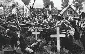 Rain having rendered small arms fire impossible, Saxon infantry (left) use musket butts and bayonets to defend the churchyard at Großbeeren against a Prussian onslaught. | |||||||
| |||||||
| Belligerents | |||||||
|
|
| ||||||
| Commanders and leaders | |||||||
|
|
| ||||||
| Strength | |||||||
| 60,000 | 80,000 | ||||||
| Casualties and losses | |||||||
|
3,000 dead and wounded, 1,500 captured, 13 guns | 1,000 dead and wounded | ||||||
In the Battles of Großbeeren and neighboring Blankenfelde and Sputendorf (23 August 1813) an allied Prussian-Swedish army under Crown Prince Charles John – formerly Marshal of France Jean-Baptiste Bernadotte – defeated the French under Marshal Oudinot. Napoleon had hoped to drive the Prussians out of the Sixth Coalition by capturing their capital, but the swamps south of Berlin combined with rain and the Marshal's ill health all contributed to the French defeat.
Prelude
Following the Battle of Bautzen, in May 1813, during the War of the Sixth Coalition, both sides agreed to a seven-week truce to plan and better prepare. When the campaign resumed, in August, Napoleon ordered an offensive drive to take the Prussian capital of Berlin. With its capture, he hoped to knock the Prussians out of the war. Meanwhile, he kept the bulk of his army on the strategic defensive, to deal with any potential moves by the large Austrian army, which had now gathered in southeastern Germany. For this task, he chose one of his bravest and best commanders, Marshal Nicolas Oudinot, to lead the offensive. Oudinot tried to turn down this honor due to his poor health. He had been wounded on several occasions during the previous year's disastrous campaign in Russia, and had not yet fully recovered. But the emperor insisted, so Oudinot with three corps of about 60,000 men advanced on Berlin.
Unknown to both Napoleon and Oudinot at the time, this strategy played right into the Coalition's hands. In accordance with their Trachenberg Plan (formulated during the truce) they would avoid any large, main engagement with Napoleon himself until after they had gathered overwhelming strength and weakened the emperor by defeating his marshals in separate, smaller battles.
Battle


From its start the offensive was plagued by misfortune. On the same day as the advance began, 19 August, heavy rain storms broke out turning the roads into muddy quagmires and making it nearly impossible to move the artillery. Further hindering the advance, the area south of Berlin was crisscrossed with small lakes and swamps. In the best of weather there were only a couple of roads by which to approach the city from the south. But rain turned many of the Prussian defensive positions into fortified islands. Oudinot was forced to advance his Corps along three separate roads, with little communication between them. General Bertrand's 4th Corps of 13,000 men and 32 cannons to the right, on the left General Guilleminot's 12th Corps of 20,000 mainly inexperienced recent recruits (nicknamed Marie-Louises). In the center was the main column of General Jean Reynier's 7th Corps of 27,000 largely French allied Saxon troops. Oudinot did not expect any serious opposition and a lack of cavalry kept him unaware of the position of the enemy. Berlin was defended by the Army of the North, commanded by Crown Prince Charles John of Sweden, formerly French Marshal Bernadotte. When Reynier's corps reached Großbeeren, he encountered the bulk of Prince Charles' army drawn up for battle. Acting without orders or support, he attacked Friedrich von Bülow's corps, which had just been reinforced by the Swedes to 38,000, and was repulsed with heavy casualties. Oudinot, unable to concentrate his army, arrived late in the day just as Reynier's Saxons had begun to waver after that general failed to rally them for another assault. Realizing the advance had been checked, and believing his army was in an exposed position, Oudinot ordered the retreat to Jüterbog after sustaining heavy losses. Reynier alone lost over 3,000 dead and wounded, 1,500 made prisoner and 13 artillery pieces.
Aftermath
The defeat at Großbeeren, combined with continued ill health, had shaken Oudinot's confidence, and he continued the general retreat to Wittenberg. Napoleon was furious with Oudinot, not so much for his defeat, but for his withdrawal to Wittenberg instead of back to Luckau. He fumed, "It is truly difficult to have fewer brains than the duke of Reggio!". Napoleon then appointed Marshal Michel Ney to lead a second drive on Berlin with the same three, now reduced and demoralized, corps and the ailing Oudinot as Ney's subordinate. The result would be the Battle of Dennewitz.
Literary reference
In 1833 Theodor Fontane – then a fourteen-year-old boy – visited the site of the Battle of Großbeeren and was deeply impressed, later writing a school essay about this battle – the first work known to have been penned by a man who would become a major German writer. Fontane recounted this reminiscence in a much later essay, written in his old age (1894). He mentioned also that his mother – at the time a young Berlin woman – had in the aftermath of the battle tended wounded soldiers, both German and French. Being of a Huguenot family who still spoke French among themselves, she was able to speak to dying French soldiers in their own language.[1]
Notes
- ↑ Theodor Fonatane, "Mein Erstling: Das Schlachtfeld von Gross-Beeren", in Kurt Schreinert and Jutta Neuendorf-Fürstenau (eds.) Meine Kinderjahre (=Sämtliche Werke, vol.XIV), pp. 189–191; quoted in Christopher Clarke, The Iron Kingdom, pp. 681–682)
References
- International Napoleonic Society
- The Encyclopedia Of Military History: From 3500 B.C. To The Present. (2nd Revised Edition 1986), R. Ernest Dupuy, and Trevor N. Dupuy. pg 761
- Memoirs of the Duke Rovigo
Coordinates: 52°21′00″N 13°18′00″E / 52.35000001°N 13.30000001°E