Blankenfelde-Mahlow
| Blankenfelde-Mahlow | |
|---|---|
|
Church in Blankenfelde | |
 Blankenfelde-Mahlow | |
Location of Blankenfelde-Mahlow within Teltow-Fläming district | |
| Coordinates: 52°21′00″N 13°24′00″E / 52.35000°N 13.40000°ECoordinates: 52°21′00″N 13°24′00″E / 52.35000°N 13.40000°E | |
| Country | Germany |
| State | Brandenburg |
| District | Teltow-Fläming |
| Government | |
| • Mayor | Ortwin Baier (SPD) |
| Area | |
| • Total | 54.89 km2 (21.19 sq mi) |
| Population (2015-12-31)[1] | |
| • Total | 26,319 |
| • Density | 480/km2 (1,200/sq mi) |
| Time zone | CET/CEST (UTC+1/+2) |
| Postal codes | 15827, 15831 |
| Dialling codes | 03379 |
| Vehicle registration | TF |
| Website | www.blankenfelde-mahlow.de |
Blankenfelde-Mahlow is a municipality in the Teltow-Fläming district of Brandenburg, Germany. It is situated approximately 3 kilometres (2 miles) south of Berlin.
History

The municipality shared its borders with the former West Berlin, and so during the period 1961-1990 it was separated.
Demography
Blankenfelde-Mahlow is the most populous rural municipality ("Gemeinde") in what was formerly East Germany, and the 9th-most populous overall in Germany (as of 31 December 2012).
-
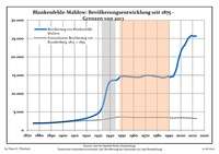
Development of Population since 1875 within the Current Boundaries (Blue Line: Population; Dotted Line: Comparison to Population Development of Brandenburg state; Grey Background: Time of Nazi rule; Red Background: Time of Communist rule)
-
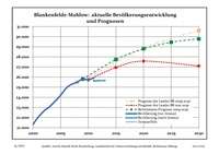
Recent Population Development (Blue Line) and Forecasts
|
|
|
|
See also
References
- ↑ "Bevölkerung im Land Brandenburg nach amtsfreien Gemeinden, Ämtern und Gemeinden 31. Dezember 2015 (Fortgeschriebene amtliche Einwohnerzahlen auf Grundlage des Zensus 2011)". Amt für Statistik Berlin-Brandenburg (in German). 2016.
- ↑ Detailed data sources are to be found in the Wikimedia Commons.Population Projection Brandenburg at Wikimedia Commons
Towns and municipalities in Teltow-Fläming | ||
|---|---|---|