Red Deer County
| Red Deer County | |
|---|---|
| Municipal district | |
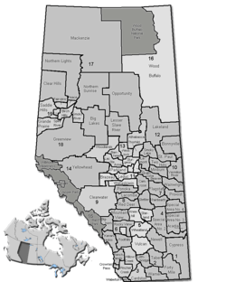 Location of Red Deer County in Alberta | |
| Coordinates: 52°16′5″N 113°48′40″W / 52.26806°N 113.81111°WCoordinates: 52°16′5″N 113°48′40″W / 52.26806°N 113.81111°W | |
| Country |
|
| Province |
|
| Region | Central Alberta |
| Census division | No. 8 |
| Established | 1944 |
| Incorporated | 1963 |
| Government[1] | |
| • Mayor | Jim Wood |
| • Governing body |
Red Deer County Council
|
| • Manager | Curtis Herzberg |
| • Office location | west of Red Deer |
| Area (2011)[2] | |
| • Total | 3,949.00 km2 (1,524.72 sq mi) |
| Population (2011)[2] | |
| • Total | 18,351 |
| • Density | 4.6/km2 (12/sq mi) |
| • Dwellings | 8,014 |
| Time zone | MST (UTC-7) |
| Website |
rdcounty |
Red Deer County is a municipal district in central Alberta, Canada within Census Division No. 8 and surrounding the City of Red Deer. The neighbouring municipalities of Red Deer County are Clearwater County to the west, Lacombe County to the north, the County of Stettler No. 6 to the east, Kneehill County to the southeast and Mountain View County to the south. It is located approximately midway between Edmonton and Calgary, bisected by the Queen Elizabeth II Highway and bounded on the north and east by the Red Deer River.
Agriculture
Red Deer County is largely an agricultural area, and much of the rural land is actively used for growing crops, feeding livestock and providing lumber and mineral resources. The County has initiated several projects to ensure that agriculture and the environment are represented as it continues to grow.
An Agricultural Profile has been created to detail the County's existing agriculture, land and water resources. The County was divided into 19 distinct geographic areas calleld County Neighbourhoods. These delineations distinguish variations in drainage, soil type, water resources, and primary production. County Neighbourhoods have specific characteristics that will assist future growth and development plans.
Livestock and crop production are an important part of the economy. The County has dairies that make cheese, U-pick vegetable and fruit farms and the largest organic farm in Alberta. Amenities for trout fishing exist at a U-fish pod. The County also has elk, deer, and apiary farms as well as a mouse farm, which raises white mice for the pet food industry.
Development
Construction of residences and most buildings in Red Deer County require County-issued development permits, to assure that proposed project are in conformance with applicable County bylaws and statutory plans and is consistent with requirements regulating property divisions and uses such as setbacks, minimum frontage, potable water supply and sewage disposal systems.
As well, permits are often required from other agencies such as Alberta Transportation or Alberta Environment. Although the County has no jurisdiction in these areas, it can assist applicants through the process.
Demographics
In the 2011 Census, Red Deer County had a population of 18,351 living in 6,643 of its 7,703 total dwellings, a -1.6% change from its 2006 adjusted population of 18,649. With a land area of 3,949 km2 (1,525 sq mi), it had a population density of 4.6/km2 (12.0/sq mi) in 2011.[2]
In 2006, Red Deer County had a population of 19,108 living in 8,014 dwellings, a 3.3% increase from 2001. The countyhas a land area of 4,002.58 km2 (1,545.40 sq mi) and a population density of 4.8/km2 (12/sq mi).[3]
According to the Canada 2001 Census:[4]
- Population: 79,082 (2005)
- % Change (1996-2001): 8.9
- Dwellings: 7,302
- Area (km².): 4,015.05
- Density (persons per km².): 19.7
Communities and localities
|
The following urban municipalities are surrounded by Red Deer County:[5][6] The following hamlets are located within Red Deer County:[6] |
The following localities are located within Red Deer County:[7]
|
|
See also
References
- ↑ "Municipal Officials Search". Alberta Municipal Affairs. December 16, 2016. Retrieved December 18, 2016.
- 1 2 3 "Population and dwelling counts, for Canada, provinces and territories, and census subdivisions (municipalities), 2011 and 2006 censuses (Alberta)". Statistics Canada. 2012-02-08. Retrieved 2012-02-08.
- ↑ Statistics Canada. "Canada 2006 Census: Red Deer County - Community Profile". Retrieved 2007-06-11.
- ↑ Red Deer County community profile - Statistics Canada. 2002. 2001 Community Profiles. Released June 27, 2002. Last modified: 2005-11-30. Statistics Canada Catalogue no. 93F0053XIE.
- ↑ "Red Deer, City (Census Subdivision), Alberta". Statistics Canada. 2012-06-20. Retrieved 2012-08-13.
- 1 2 "Specialized and Rural Municipalities and Their Communities" (PDF). Alberta Municipal Affairs. 2012-03-01. Retrieved 2012-08-12.
- ↑ "Standard Geographical Classification (SGC) 2006, Economic Regions: 4808001 - Red Deer County, geographical codes and localities, 2006". Statistics Canada. 2010-03-05. Retrieved 2012-08-12.
External links
 |
Clearwater County | Lacombe County | | |
| Clearwater County | |
County of Stettler No. 6 | ||
| ||||
| | ||||
| Mountain View County | Kneehill County | Starland County |