Lacombe County
| Lacombe County | |
|---|---|
| Municipal district | |
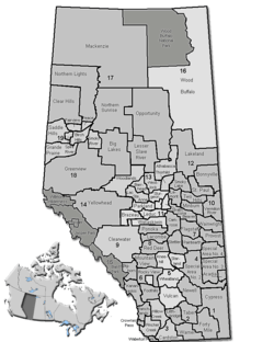 Location of Lacombe County in Alberta | |
| Coordinates: 52°28′6″N 113°44′13″W / 52.46833°N 113.73694°WCoordinates: 52°28′6″N 113°44′13″W / 52.46833°N 113.73694°W | |
| Country |
|
| Province |
|
| Region | Central Alberta |
| Census division | No. 8 |
| Established | 1944 |
| Incorporated | 1995 |
| Government[1] | |
| • Reeve | Paula Law |
| • Governing body |
Lacombe County Council
|
| • Commissioner | Terry Hager |
| • Office location | west of Lacombe |
| Area (2011)[2] | |
| • Total | 2,766.65 km2 (1,068.21 sq mi) |
| Population (2011)[2] | |
| • Total | 10,312 |
| • Density | 3.7/km2 (10/sq mi) |
| • Dwellings | 4,008 |
| Time zone | MST (UTC-7) |
| Website |
lacombecounty |
Lacombe County is a municipal district in central Alberta, Canada, located in Census Division No. 8 north of the City of Red Deer. Its municipal office is 4 km (2.5 mi) west of Highway 2 and the City of Lacombe, and 6 km (3.7 mi) east of the Summer Village of Gull Lake, at the intersection of Highway 12 and Spruceville Road (Range Road 274).
Demographics
In the 2011 Census, Lacombe County had a population of 10,312 living in 3,715 of its 4,317 total dwellings, a -0.8% change from its 2006 adjusted population of 10,394. With a land area of 2,766.65 km2 (1,068.21 sq mi), it had a population density of 3.7/km2 (9.7/sq mi) in 2011.[2]
The population of Lacombe County according to its 2008 municipal census is 10,507.[3]
In 2006, Lacombe County had a population of 10,451 living in 4,008 dwellings, a 1.1% decrease from 2001. The county has a land area of 2,777.26 km2 (1,072.31 sq mi) and a population density of 3.8/km2 (9.8/sq mi).[4]
In 2001, Lacombe County had a population of 10,159 in 3,790 dwellings, a 4.1% increase from 1996. On a surface of 2,781.66 km² it had a density of 3.7 inhabitants/km².[5]
Communities and localities
|
The following urban municipalities are surrounded by Lacombe County:[6][7] The following hamlets are located within Lacombe County:[7]
|
The following localities are located within Lacombe County:[8]
|
|
See also
References
- ↑ "Municipal Officials Search". Alberta Municipal Affairs. November 18, 2016. Retrieved November 21, 2016.
- 1 2 3 "Population and dwelling counts, for Canada, provinces and territories, and census subdivisions (municipalities), 2011 and 2006 censuses (Alberta)". Statistics Canada. 2012-02-08. Retrieved 2012-02-08.
- ↑ Alberta Municipal Affairs (2009-09-15). "Alberta 2009 Official Population List" (PDF). Retrieved 2010-09-12.
- ↑ Statistics Canada. "Canada 2006 Census: Lacombe County - Community Profile". Retrieved 2007-06-11.
- ↑ Lacombe County community profile - Statistics Canada. 2002. 2001 Community Profiles. Released June 27, 2002. Last modified: 2005-11-30. Statistics Canada Catalogue no. 93F0053XIE
- ↑ "Lacombe, City (Census Subdivision), Alberta". Statistics Canada. 2012-06-20. Retrieved 2012-08-13.
- 1 2 "Specialized and Rural Municipalities and Their Communities" (PDF). Alberta Municipal Affairs. 2012-03-01. Retrieved 2012-08-11.
- ↑ "Standard Geographical Classification (SGC) 2006, Economic Regions: 4808022 - Lacombe County, geographical codes and localities, 2006". Statistics Canada. 2010-03-05. Retrieved 2012-08-11.
External links
 |
Clearwater County | Ponoka County | Camrose County | |
| Clearwater County | |
County of Stettler No. 6 | ||
| ||||
| | ||||
| Clearwater County | Red Deer County | County of Stettler No. 6 |