Municipal District of Lesser Slave River No. 124
| Municipal District of Lesser Slave River No. 124 | ||
|---|---|---|
| Municipal district | ||
|
Boundary sign | ||
| ||
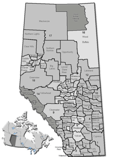 Location of Lesser Slave River No. 124 in Alberta | ||
| Coordinates: 55°17′7″N 114°46′14″W / 55.28528°N 114.77056°WCoordinates: 55°17′7″N 114°46′14″W / 55.28528°N 114.77056°W | ||
| Country |
| |
| Province |
| |
| Region | Northern Alberta | |
| Census division | No. 17 | |
| Established | 1993 | |
| Incorporated | 1995 | |
| Government[1] | ||
| • Reeve | Murray Kerik | |
| • Governing body | M.D. of Lesser Slave River Council | |
| • Office location | Slave Lake | |
| Area (2011)[2] | ||
| • Total | 10,075.88 km2 (3,890.32 sq mi) | |
| Population (2011)[2] | ||
| • Total | 2,929 | |
| • Density | 0.3/km2 (0.8/sq mi) | |
| • Dwellings | 1,216 | |
| Time zone | MST (UTC−7) | |
| • Summer (DST) | MDT (UTC−6) | |
| Website | Official website | |

The Municipal District of Lesser Slave River No. 124 is a municipal district in north-central Alberta, Canada. Its municipal office is located in the Town of Slave Lake. Located in Census Division 17, the municipal district takes its name from Lesser Slave River, which drains Lesser Slave Lake into the Athabasca River.
Demographics
The population of the Municipal District of Lesser Slave River No. 124 according to its 2014 municipal census is 3,074,[3] a 5% change from its 2011 population of 2,929.[2]
In the 2011 Census, the Municipal District of Lesser Slave River No.124 had a population of 2,929 living in 1,111 of its 1,438 total dwellings, a 3.9% change from its 2006 population of 2,820. With a land area of 10,075.88 km2 (3,890.32 sq mi), it had a population density of 0.3/km2 (0.8/sq mi) in 2011.[2]
In 2006, Lesser Slave River No. 124 had a population of 2,820 living in 1,216 dwellings, a 0.0% increase from 2001. The municipal district has a land area of 10,075.88 km2 (3,890.32 sq mi) and a population density of 0.3/km2 (0.78/sq mi).[4]
In 2001, the municipal district had a population of 2,825 in 1,275 dwellings, a 4% increase from 1996. On a surface of 10,062.73 km² it had a density of 0.3 inhabitants/km².[5]
Communities and localities
The following urban municipalities are surrounded by the Municipal District of Lesser Slave River No. 124:[6]
|
The following hamlets are located within the Municipal District of Lesser Slave River No. 124:[6] |
The following localities are located within the Municipal District of Lesser Slave River No. 124:[7]
- Localities
|
|
- Other places
See also
References
- ↑ "Municipal Officials Search". Alberta Municipal Affairs. November 18, 2016. Retrieved November 21, 2016.
- 1 2 3 4 "Population and dwelling counts, for Canada, provinces and territories, and census subdivisions (municipalities), 2011 and 2006 censuses (Alberta)". Statistics Canada. 2012-02-08. Retrieved 2012-02-08.
- ↑ "Agenda: Municipal District #124 Council Meeting 2014 Municipal Census Update" (PDF) (PDF). Municipal District of Lesser Slave River No. 124. July 8, 2014. pp. 69 70. Retrieved July 18, 2014.
- ↑ Statistics Canada. "Canada 2006 Census: Lesser Slave River No. 124 - Community Profile". Retrieved 2007-06-11.
- ↑ MD of Lesser Slave River community profile - Statistics Canada. 2002. 2001 Community Profiles. Released June 27, 2002. Last modified: 2005-11-30. Statistics Canada Catalogue no. 93F0053XIE
- 1 2 "Specialized and Rural Municipalities and Their Communities" (PDF). Alberta Municipal Affairs. 2012-03-01. Retrieved 2012-08-11.
- ↑ "Standard Geographical Classification (SGC) 2006, Economic Regions: 4817033 - Lesser Slave River No.124, geographical codes and localities, 2006". Statistics Canada. 2010-03-05. Retrieved 2012-08-11.
External links
 |
Northern Sunrise County | Municipal District of Opportunity No. 17 | Municipal District of Opportunity No. 17 | |
| Big Lakes County | |
Municipal District of Opportunity No. 17 | ||
| ||||
| | ||||
| Woodlands County | Westlock County | Athabasca County |