Yellowhead County
| Yellowhead County | |
|---|---|
| Municipal district | |
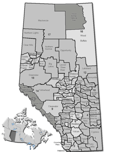 Location of Yellowhead County in Alberta | |
| Coordinates: 53°34′54″N 116°26′4″W / 53.58167°N 116.43444°WCoordinates: 53°34′54″N 116°26′4″W / 53.58167°N 116.43444°W | |
| Country |
|
| Province |
|
| Region | Central Alberta |
| Census division | No. 14 |
| Established | 1994 |
| Incorporated | 1994 |
| Government[1] | |
| • Mayor | Gerald Soroka |
| • Governing body |
Yellowhead County Council
|
| • CAO | Jack Ramme |
| • Office location | Edson |
| Area (2011)[2] | |
| • Total | 22,296.26 km2 (8,608.63 sq mi) |
| Population (2011)[2] | |
| • Total | 10,469 |
| • Density | 0.47/km2 (1.2/sq mi) |
| • Dwellings | 4,177 |
| Time zone | MST (UTC-7) |
| Website |
yellowheadcounty |


Yellowhead County is a municipal district in west central Alberta, Canada.
It is the only county in Alberta Division 14, and shares the boundaries with this census division.
History
- 1994: Established as a Municipal District of Yellowhead No. 94 on January 1.
- 1998: The name changed to Yellowhead County on July 8.[3]
- 1998: Evansburg dissolved as a village, and became part of Yellowhead Municipal District on June 30.
Demographics
In the 2011 Census, Yellowhead County had a population of 10,469 living in 4,083 of its 4,708 total dwellings, a 4.2% change from its 2006 population of 10,045. With a land area of 22,296.26 km2 (8,608.63 sq mi), it had a population density of 0.5/km2 (1.2/sq mi) in 2011.[2]
In 2006, Yellowhead County had a population of 10,045 living in 4,177 dwellings, a 1.7% increase from 2001. The municipal district has a land area of 22,303.82 km2 (8,611.55 sq mi) and a population density of 0.5/km2 (1.3/sq mi).[4]
Communities and localities
The following urban municipalities are surrounded by Yellowhead County:[5]
The following localities are located within Yellowhead County:[6]
|
|
See also
References
- ↑ "Municipal Officials Search". Alberta Municipal Affairs. December 16, 2016. Retrieved December 18, 2016.
- 1 2 3 "Population and dwelling counts, for Canada, provinces and territories, and census subdivisions (municipalities), 2011 and 2006 censuses (Alberta)". Statistics Canada. 2012-02-08. Retrieved 2012-02-08.
- ↑ Alberta Municipal Affairs. "Yellowhead County municipal profile". Retrieved 2008-04-16.
- ↑ Statistics Canada. "Canada 2006 Census: Yellowhead County - Community Profile". Retrieved 2007-06-10.
- 1 2 "Specialized and Rural Municipalities and Their Communities" (PDF). Alberta Municipal Affairs. 2012-03-01. Retrieved 2012-08-12.
- ↑ "Standard Geographical Classification (SGC) 2006, Economic Regions: 4814003 - Yellowhead County, geographical codes and localities, 2006". Statistics Canada. 2010-03-05. Retrieved 2012-08-12.
External links
| Wikimedia Commons has media related to Yellowhead County, Alberta. |
 |
Municipal District of Greenview No. 16 | Woodlands County | Lac Ste. Anne County | |
| Willmore Wilderness Park | |
Parkland County | ||
| ||||
| | ||||
| Jasper National Park | Clearwater County | Brazeau County |