Municipal District of Greenview No. 16
| Municipal District of Greenview No. 16 | ||
|---|---|---|
| Municipal district | ||
|
Municipal Building in Valleyview | ||
| ||
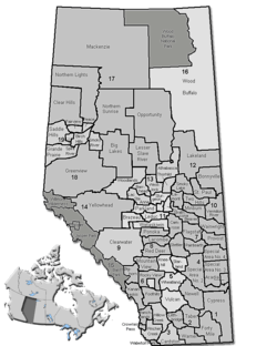 Location of Greenview No. 16 in Alberta | ||
| Coordinates: 55°04′7″N 117°16′6″W / 55.06861°N 117.26833°WCoordinates: 55°04′7″N 117°16′6″W / 55.06861°N 117.26833°W | ||
| Country |
| |
| Province |
| |
| Region | Northern Alberta | |
| Census division | No. 18 | |
| Established | 1994 | |
| Government[1] | ||
| • Reeve | Dale Gervais | |
| • Governing body | M.D. of Greenview Council | |
| • Office location | Valleyview | |
| Area (2011)[2] | ||
| • Total | 32,989.05 km2 (12,737.14 sq mi) | |
| Population (2011)[2] | ||
| • Total | 5,299 | |
| • Density | 0.2/km2 (0.5/sq mi) | |
| • Dwellings | 2,064 | |
| Time zone | MST (UTC-7) | |
| Website |
mdgreenview | |

The Municipal District of Greenview No. 16 is a municipal district in northwest Alberta, Canada.
It covers the full extent of Census Division 18. Its municipal office is located in the Town of Valleyview.
Demographics
The Municipal District of Greenview No. 16's 2013 municipal census counted a population of 5,242,[3] a −5% change from its 2000 municipal census population of 5,516.[4]
In the 2011 Census, the Municipal District of Greenview No. 16 had a population of 5,299 living in 1,970 of its 2,197 total dwellings, a -3% change from its 2006 population of 5,464. With a land area of 32,989.05 km2 (12,737.14 sq mi), it had a population density of 0.2/km2 (0.4/sq mi) in 2011.[2]
In 2006, Greenview No. 16 had a population of 5,464 living in 2,064 dwellings, a 0.5% increase from 2001. The municipal district has a land area of 32,994.14 km2 (12,739.11 sq mi) and a population density of 0.2/km2 (0.52/sq mi).[5]
In 2001, the municipal district had a population of 5,439 in 2,002 dwellings, a 0.1% increase from 1996. On a surface of 33,383.92 km² it had a density of 0.2 inhabitants/km².[6]
Communities and localities
|
The following urban municipalities are surrounded by the Municipal District of Greenview No. 16:[7]
The following hamlets are located within the Municipal District of Greenview No. 16:[7] |
The following localities are located within the Municipal District of Greenview No. 16:[8]
|
|
See also
References
- ↑ "Municipal Officials Search". Alberta Municipal Affairs. November 18, 2016. Retrieved November 21, 2016.
- 1 2 3 "Population and dwelling counts, for Canada, provinces and territories, and census subdivisions (municipalities), 2011 and 2006 censuses (Alberta)". Statistics Canada. 2012-02-08. Retrieved 2012-02-08.
- ↑ "2013 Census Newsletter" (PDF) (PDF). Municipal District of Greenview No. 16. Retrieved December 5, 2013.
- ↑ "2000 Official Population List" (PDF) (PDF). Alberta Municipal Affairs. September 1, 2000. Retrieved December 5, 2013.
- ↑ Statistics Canada. "Canada 2006 Census: Greenview No. 16 - Community Profile". Retrieved 2007-06-11.
- ↑ Greenview community profile - Statistics Canada. 2002. 2001 Community Profiles. Released June 27, 2002. Last modified: 2005-11-30. Statistics Canada Catalogue no. 93F0053XIE
- 1 2 "Specialized and Rural Municipalities and Their Communities" (PDF). Alberta Municipal Affairs. 2012-03-01. Retrieved 2012-08-11.
- ↑ "Standard Geographical Classification (SGC) 2006, Economic Regions: 4818015 - Greenview No. 16, geographical codes and localities, 2006". Statistics Canada. 2010-03-05. Retrieved 2012-08-11.
- ↑ "Ward 4: Sunset House & Sweathouse" (PDF) (PDF). Municipal District of Greenview No. 16. June 2, 2010. Retrieved June 30, 2014.
External links

| Subdivisions | |||||||||||
|---|---|---|---|---|---|---|---|---|---|---|---|
| Communities | |||||||||||
| Cities and urban service areas | |||||||||||
| Rural municipalities |
| ||||||||||
| Specialized municipalities | |||||||||||
| |||||||||||