Sageland, California
| Sageland | |
|---|---|
| Unincorporated community | |
 Sageland  Sageland Location in California | |
| Coordinates: 35°28′48″N 118°12′45″W / 35.48000°N 118.21250°WCoordinates: 35°28′48″N 118°12′45″W / 35.48000°N 118.21250°W | |
| Country | United States |
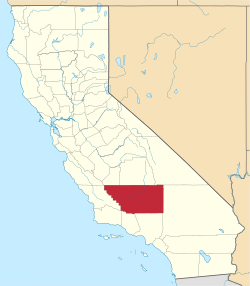
| State | California |
| County | Kern County |
| Elevation[1] | 4,026 ft (1,227 m) |
Sageland (formerly, El Dorado Camp)[2] is an unincorporated community in Kern County, California.[1] It is located near Kelso Creek 3.5 miles (5.6 km) west-northwest of the Pinyon Mountains,[2] at an elevation of 4026 feet (1227 m).[1]
Quartz was discovered in the area in the mid-1860s. Sageland began as The New El Dorado Mining District in 1866; the name Sageland was applied in 1867. By the spring of 1868, Sageland had become a boomtown with a population of almost a thousand, complete with multiple saloons, a billiard room, hotel, two stage lines to Havilah, and an opera house. Later that year, a silver rush occurred in White Pine county, Nevada, attracting legions of miners from Sageland and other California boom towns, an exodus known as 'White Pine Fever'. The St. John Mine closed in 1875 and by the next year, Sageland was essentially a ghost town. No structures remain from the original settlement, only fragments of stone walls.
The area was the site of a large village of Kawaiisu Indians. They were frequently accused of cattle rustling by white settlers, who would often retaliate mercilessly. [2] Cupholes and pictographs are present in the vicinity.