Frazier Park, California
| Frazier Park | |
|---|---|
| Unincorporated community | |
|
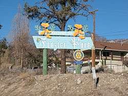
Entrance to Frazier Park | |
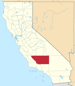
 Location in Kern County and the state of California | |
 Frazier Park Location in the United States | |
| Coordinates: 34°49′22″N 118°56′41″W / 34.82278°N 118.94472°WCoordinates: 34°49′22″N 118°56′41″W / 34.82278°N 118.94472°W | |
| Country |
|
| State |
|
| County | Kern |
| Government | |
| • County supervisor | David Couch |
| • Senate | Jean Fuller (R) |
| • Assembly | Shannon Grove (R) |
| • U. S. Congress | Kevin McCarthy (R) |
| Area[1] | |
| • Total | 5.066 sq mi (13.120 km2) |
| • Land | 5.064 sq mi (13.116 km2) |
| • Water | 0.002 sq mi (0.004 km2) 0.03% |
| Elevation[2] | 4,639 ft (1,414 m) |
| Population (2010) | |
| • Total | 2,691 |
| • Density | 530/sq mi (210/km2) |
| Time zone | PST (UTC-8) |
| • Summer (DST) | PDT (UTC-7) |
| ZIP codes | 93222, 93225 |
| Area code(s) | 661 |
| FIPS code | 06-25534 |
| GNIS feature ID | 1656523 |
Frazier Park is an unincorporated community in Kern County, California. It is 5 miles (8 km) west of Lebec,[3] at an elevation of 4,639 feet (1,414 m).[2] It is one of the Mountain Communities of the Tejon Pass. The population was 2,691 in the 2010 census, up from 2,348 in 2000.
History
The earliest record relating to Frazier Park was a report in 1854 that lumber was being produced there from Frazier Mountain trees for use at the new Army post at nearby Fort Tejon. Local historian Bonnie Ketterl Kane wrote that the mill was "supposedly" at the southeast end of the present community. She cited another report that a Kitanemuk Indian referred to the site Campo del Soldado (Soldier's Camp), "which was where the soldiers stayed when they cut timber from a mountain they called Pinery Mountain, today's Frazier Mountain."[4]
The community itself was established in 1925 by Harry McBain, who named it in 1926 for Frazier Mountain, on its southern flank. Its post office was established on September 14, 1927, with Charles B. Fife as the first postmaster.[5] The current Mayor of Frazier Park is Thomas Lauchlan.
Frazier Park was also used in filming for The Waltons television show.[6]
Frazier Park is also the setting of the 2011 film The FP.[7]
Geography
Frazier Park lies within Cuddy Canyon in the San Emigdio Mountains, within the Los Padres National Forest. Mount Pinos is the highest peak in the area at 8,831 ft (2,692 m).
Other nearby communities include Lake of the Woods (3.6 miles), Lebec (4.6 miles), Pine Mountain Club (14.5 miles), and Mettler (16.7 miles). Santa Clarita is the nearest large city, to the south on Interstate 5.
The San Andreas fault runs through the region, turning southeast on the west side of Interstate 5, just southwest of the Frazier Park exit in what is known as the Big Bend of the San Andreas.
The nearest highway is Interstate 5 (I-5), east of the community. The main road through Frazier Park is Frazier Mountain Park Road, which runs east to Lebec and I-5 and west to Lake of the Woods.
Climate
This region experiences warm (but not hot) and dry summers, with no average monthly temperatures above 71.6 °F. According to the Köppen Climate Classification system, Frazier Park has a warm-summer Mediterranean climate, abbreviated "Csb" on climate maps.[8]
Population
2010
The 2010 United States Census[9] reported that Frazier Park had a population of 2,691. The population density was 531.2 people per square mile (205.1/km²). The racial makeup of Frazier Park was 2,297 (85.4%) White, 16 (0.6%) African American, 31 (1.2%) Native American, 22 (0.8%) Asian, 3 (0.1%) Pacific Islander, 212 (7.9%) from other races, and 110 (4.1%) from two or more races. Hispanic or Latino of any race were 528 persons (19.6%).
The Census reported that 2,691 people (100% of the population) lived in households, 0 (0%) lived in non-institutionalized group quarters, and 0 (0%) were institutionalized.
There were 1,086 households, out of which 342 (31.5%) had children under the age of 18 living in them, 487 (44.8%) were opposite-sex married couples living together, 116 (10.7%) had a female householder with no husband present, 69 (6.4%) had a male householder with no wife present. There were 83 (7.6%) unmarried opposite-sex partnerships, and 7 (0.6%) same-sex married couples or partnerships. 312 households (28.7%) were made up of individuals and 97 (8.9%) had someone living alone who was 65 years of age or older. The average household size was 2.48. There were 672 families (61.9% of all households); the average family size was 3.08.
The population was spread out with 643 people (23.9%) under the age of 18, 243 people (9.0%) aged 18 to 24, 616 people (22.9%) aged 25 to 44, 874 people (32.5%) aged 45 to 64, and 315 people (11.7%) who were 65 years of age or older. The median age was 40.4 years. For every 100 females there were 100.7 males. For every 100 females age 18 and over, there were 102.0 males.
There were 1,354 housing units at an average density of 267.3 per square mile (103.2/km²), of which 673 (62.0%) were owner-occupied, and 413 (38.0%) were occupied by renters. The homeowner vacancy rate was 4.5%; the rental vacancy rate was 10.0%. 1,627 people (60.5% of the population) lived in owner-occupied housing units and 1,064 people (39.5%) lived in rental housing units.
2000
A total of 2,348 people lived in Frazier Park in 2000,[10] of which 2,055 (87 percent) were white. Other residents included 34 American Indians or Alaska natives, 19 Asians, and 14 blacks. There were 292 Hispanics or Latinos of any race.
The median age for Frazier Park residents was 38 years compared with 35 for the nation as a whole.
Frazier Park also had slightly more veterans than its share — 293, or 17 percent, compared to 13 percent around the country.
It had a significantly higher percentage of disabled people than the rest of the nation — 36 percent against 19 percent.
In contrast with the country at large, where 64 percent of the adults were working, Frazier Park had just 48 percent employed. Those who were working had to travel some 42 minutes to their jobs, compared to 25 minutes for most Americans.
Frazier Park households had a lower median income than the nation as a whole — $46,857, compared to $50,046.
There were 291 people (or 12 percent) below the poverty level in Frazier Park in 2000. That is the same proportion as the country as a whole.
Almost a quarter of Frazier Park's 1,203 housing units (23 percent) were vacant when the census was taken in March 2000 — much higher than the national rate of 9 percent. This may be explained by the fact that many Frazier Park properties are second or seasonal homes. Property owners lived in about seven of every 10 occupied units, renters in the other three — just about the same as in the rest of the nation.
Government
Frazier Park is governed by the Kern County Board of Supervisors. On August 13, 2009, County Supervisor Ray Watson announced that he wanted to appoint an advisory council to assist him in the governance of the area, which includes Frazier Park, Lebec, Fort Tejon and Tejon Village, Pinon Pines, Lake of the Woods, and Pine Mountain Club. A resolution to form the Mountain Communities Municipal Advisory Council and its bylaws would be brought to the Kern County Board of Supervisors for approval, he said.
The five members he selected for initial appointment were Stacey Havener, Linda MacKay, Steve Newman, Robert Peterson, and Anne Weber. “These individuals were selected based on demonstrated leadership, community service and broad representation of community interests and geographic areas," Watson said. "We are leaving open the option to extend membership to seven at some point depending on the need to represent additional interests within the communities.
Havener, a real estate broker and president of the Mountain Communities Chamber of Commerce, lives in Pine Mountain Club. MacKay of Frazier Park works for the Family Resource Center. She has served two terms on the Mountain Communities Town Council, one term as president. She is one of the original group that researched and suggested the formation of MCMAC. Newman, retired after 34 years as a sergeant of the Los Angeles Sheriff Department, lives in Frazier Park. He has been a member of the El Tejon Unified School District Board for nine years, four of them as chairman. Peterson of Lebec works for Tejon Ranch. He has 28 years of experience in real estate, land planning, economic development and maintenance of sustainable development standards. He serves on the Tehachapi Fire Safety Council. Weber lives in Frazier Park. She established the Mountain Communities Family Resource Center in 1999.[11]
Education
The community is a part of the El Tejon Unified School District. Frazier Park Elementary School is the only non-charter school that lies within Frazier Park; it educates children in kindergarten through fourth grade. El Tejon Middle School in Lebec takes district students from the fifth through the eighth grade. Frazier Mountain High School, also in Lebec, was founded in 1995 for ninth- through 12th-graders.[12]
Homeschooling is important in Frazier Park and surrounding areas, according to a March 2008 report in the Mountain Enterprise, which added:
Per capita, the Mountain Communities may have one of the highest rates of homeschooling in the state, far above the national average of 2 to 4 percent, Holly Van Houten . . . [a home-school parent of the area] said. Estimates range between 8 and 30 percent—somewhere between 100 and 400 children, she reports.[13]
Frazier Park hosts a branch of the Valley Oaks Community Charter School, headquartered in Bakersfield. The charter school is designed to "provide opportunities, support, and accountability for parents in their homeschooling endeavors." [14]
Transportation
Kern Regional Transit provides bus service Mondays through Saturdays during the summer months to Lebec, Gorman, Lake of the Woods, Pinon Pines, and Pine Mountain Club. It offers a dial-a-ride service all year. Connections can be made in Lebec to a scheduled service via Kern Regional Transit to Bakersfield or via Amtrak bus to Newhall and further connection in those cities to Greyhound and Amtrak train in Bakersfield[15] or MetroLink in Newhall.[16]
Communications
Wired telephone numbers in Frazier Park follow the format (661) 245-xxxx. The ZIP Code is 93225.
In popular culture
The Black 6 (1973), a blaxploitation biker film directed by Matt Cimber and featuring several NFL stars was made in the area.
In 2011, an American independent film The FP was released. The comedy film written and directed by brothers Brandon and Jason Trost focuses on two gangs—the 248 and the 245—that are fighting for control of The FP (i.e. Frazier Park).
See also
- The Mountain Enterprise newspaper, which circulates in Frazier Park and the surrounding area.
- 1857 Fort Tejon earthquake
References
- ↑ U.S. Census Archived 2012-07-14 at WebCite
- 1 2 U.S. Geological Survey Geographic Names Information System: Frazier Park, California
- ↑ Durham, David L. (1998). California's Geographic Names: A Gazetteer of Historic and Modern Names of the State. Clovis, Calif.: Word Dancer Press. p. 1037. ISBN 1-884995-14-4.
- ↑ A View From the Ridge Route, Volume II, "The Fort Tejon Era," Bonnie's Books, 2002. ISBN 0-9703992-2-7
- ↑ Richard Bailey, Kern County Place Names, cited in Curtis Darling, Kern County Place Names, Pioneer Publishing Co., 1998.
- ↑ Imaging service for Northern California libraries
- ↑ http://drafthousefilms.com/film/the-fp
- ↑ Climate Summary for Frazier Park, California
- ↑ "2010 Census Interactive Population Search: CA - Frazier Park CDP". U.S. Census Bureau. Retrieved July 12, 2014.
- ↑ "American FactFinder". United States Census Bureau. Archived from the original on 2013-09-11. Retrieved 2008-01-31.
- ↑ " Mtn. Communities Municipal Advisory Council Members Selected," Mountain Enterprise, August 14, 2009
- ↑ Home page of the El Tejon Unified School District.
- ↑ "Mountain's home schools oppose state intrusion," Mountain Enterprise, March 14, 2008.
- ↑ Mission statement of Charter Oaks Community Charter School.
- ↑ Kern Regional Transit bus routes
- ↑ Katy Penlund, "Lebec, New Gateway to the World as Amtrak Bus Service Begins to Santa Clarita/Newhall," Mountain Enterprise, January 09, 2009
External links
Newspapers
- The Mountain Enterprise, weekly newspaper
- The Bakersfield Californian The Californian discontinued circulation in the Mountain Communities effective May 1, 2009. Source: Mountain Enterprise, April 3, 2009
- "GBU Mountain News", a weekly electronic newspaper that encompasses social media and video components and has served the Frazier Mountain Communities since July 2013
Organizations
- Center of the World Festival
- Rotary Club of Frazier Park and Mountain Communities
- Mountain Communities Chamber of Commerce