Boron, California
| Boron | |
|---|---|
| census-designated place | |
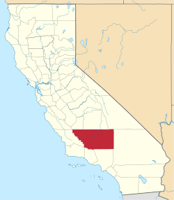
 Location in Kern County and the state of California | |
 Boron Location in the United States | |
| Coordinates: 34°59′58″N 117°38′59″W / 34.99944°N 117.64972°WCoordinates: 34°59′58″N 117°38′59″W / 34.99944°N 117.64972°W | |
| Country | United States |
| State | California |
| County | Kern |
| Government | |
| • State senator | Jean Fuller (R)[1] |
| • Assemblymember | Tom Lackey (R)[1] |
| • U. S. rep. | Kevin McCarthy (R)[2] |
| Area[3] | |
| • Total | 13.821 sq mi (35.796 km2) |
| • Land | 13.800 sq mi (35.742 km2) |
| • Water | 0.021 sq mi (0.054 km2) 0.15% |
| Elevation[4] | 2,467 ft (752 m) |
| Population (2010) | |
| • Total | 2,253 |
| • Density | 160/sq mi (63/km2) |
| Time zone | PST (UTC-8) |
| • Summer (DST) | PDT (UTC-7) |
| ZIP codes | 93516, 93596 |
| Area codes | 442/760 |
| FIPS code | 06-07568 |
| GNIS feature ID | 1652674 |
Boron (formerly, Amargo, Baker, Borate, and Kern)[4] is a census-designated place (CDP) in Kern County, California, United States. Boron is 15 miles (24 km) east-southeast of Castle Butte at an elevation of 2,467 feet (752 m).[4] The population was 2,253 at the 2010 census, up from 2,025 at the 2000 census. Boron is named after the element boron and is the site of the world's largest source of the boron compound boric acid.
Boron is a hinterland community on the western edge of the Mojave Desert. Within a half day's drive one can view the highest and lowest points in the contiguous 48 states of the United States (Mount Whitney and Death Valley), the world's oldest tree, the bristlecone pine, and the cities of both Los Angeles and Las Vegas.
Boron is home to the U.S. Borax Boron Mine, California's largest open-pit mine, which is also the largest borax mine in the world. 35°2′34.44″N 117°40′45.41″W / 35.0429000°N 117.6792806°W
Geography

Boron is on the border of Kern and San Bernardino Counties along State Route 58. The coordinates are: 34°59′58″N 117°38′59″W / 34.99944°N 117.64972°W.[4] Boron is 65 miles (105 km) north of Palmdale, 85 miles (137 km) east of Bakersfield, and 40 miles (64 km) west of Barstow in the Antelope Valley region of California's Mojave Desert. According to the United States Census Bureau, the CDP has a total area of 13.8 square miles (36 km2), over 99 percent of its land.
Demographics
2010 census
The 2010 United States Census[5] reported that Boron had a population of 2,253. The population density was 163.0 people per square mile (62.9/km²). The racial makeup of Boron was 1,746 (77.5 percent) White, 162 (7.2 percent) African American, 49 (2.2 percent) Native American, 47 (2.1 percent) Asian, 4 (0.2 percent) Pacific Islander, 141 (6.3 percent) from other races, and 104 (4.6 percent) from two or more races. Hispanic or Latino of any race were 406 persons (18.0 percent).
The census reported that 2,253 people (100 percent of the population) lived in households, zero percent lived in non-institutionalized group quarters, and none were institutionalized.
There were 892 households, out of which 295 (33.1 percent) had children under the age of 18 living in them, 364 (40.8 percent) were opposite-sex married couples living together, 126 (14.1 percent) had a female householder with no husband present, 61 (6.8 percent) had a male householder with no wife present. There were 67 (7.5 percent) unmarried opposite-sex partnerships, and three (0.3 percent) same-sex married couples or partnerships. 294 households (33 percent) were made up of individuals and 112 (12.6 percent) had someone living alone who was 65 years of age or older. The average household size was 2.53. There were 551 families (61.8 percent of all households); the average family size was 3.21.

The population was spread out with 621 people (27.6 percent) under the age of 18, 173 people (7.7 percent) aged 18 to 24, 472 people (20.9 percent) aged 25 to 44, 691 people (30.7 percent) aged 45 to 64, and 296 people (13.1 percent) who were 65 years of age or older. The median age was 39.3 years. For every 100 females there were 106.9 males. For every 100 females age 18 and over, there were 107.1 males.
There were 1,208 housing units at an average density of 87.4 per square mile (33.7/km²), of which 505 (56.6 percent) were owner-occupied, and 387 (43.4 percent) were occupied by renters. The homeowner vacancy rate was 3.2 percent; the rental vacancy rate was 31.4 percent. 1,246 people (55.3 percent of the population) lived in owner-occupied housing units and 1,007 people (44.7 percent) lived in rental housing units.
2000 census
As of the census[6] of 2000, there were 2,025 people, 801 households, and 535 families residing in the CDP. The population density was 146.2 people per square mile (56.5/km²). There were 1,103 housing units at an average density of 79.6 per square mile (30.7/km²). The racial makeup of the CDP was 85.04 percent White, 2.22 percent Black or African American, 2.86 percent Native American, 1.58 percent Asian, 0.10 percent Pacific Islander, 4.74 percent from other races, and 3.46 percent two or more races. Nine percent of the population were Hispanic or Latino of any race.
There were 801 households out of which 31.2 percent had children under the age of 18 living with them, 51.7 percent were married couples living together, 10.2 percent had a female householder with no husband present, and 33.1 percent were non-families. 29.1 percent of all households were made up of individuals and 9.9 percent had someone living alone who was 65 years of age or older. The average household size was 2.53 and the average family size was 3.11.
In the CDP the age distribution of the population shows 28 percent under the age of 18, 6.7 percent 18 to 24, 25.2 percent from 25 to 44, 26.9 percent from 45 to 64, and 13.2 percent who were 65 years of age or older. The median age was 39 years. For every 100 females there were 100.1 males. For every 100 females age 18 and over, there were 101.0 males.
The median income for a household in the CDP was $40,625, and the median income for a family was $44,674. Males had a median income of $47,045 versus $23,854 for females. The per capita income for the CDP was $18,294. About 15.2 percent of families and 19.7 percent of the population were below the poverty line, including 32.8 percent of those under age 18 and 19.4 percent of those age 65 or over.
History

"Dr. J. K. Suckow was drilling a well for water 4½ miles northwest of Boron when he discovered colemanite, a borax ore, in October 1913. After his discovery, mining claims, mostly placer, were staked in the area. The Pacific Coast Borax Company, upon recommendation of its field engineer, Clarence Rasor, acquired many of these claims, including the discovery well. The company then started explorations to determine the extent of the ore body. Suckow continued to have an interest in the area, working prospects east of his discovery well.
"In 1924, anxious to repeat his good fortune, Suckow sank a shaft one-half mile away from his first, and he struck basalt at 180 feet (55 m). The Pacific Coast Borax Company prospected in the same area, with almost the same results: basalt at 190 feet (58 m). However, persistence paid off. That same year Suckow sank another shaft just a little south of his last one and found a 70-foot (21 m) thick bed of colemanite at 210 feet (64 m). In 1925 the Suckow Chemical Company produced a few hundred tons of colemanite from this shaft.
"In the Spring of 1925, William M. Dowsing and J. L. Hannan discovered a huge deposit 120 feet (37 m) thick just 1½ miles west of Suckow's shaft, which they kept a secret until its extent was proven. Sold to the Pacific Coast Borax Company in early 1926, it became known as the Baker Mine. Beginning production in 1927, it yielded a substantial percentage of the borates produced in the Kramer District until 1935.
"Production began in December, 1929, at the Suckow Mine, located near the Baker Mine. Suckow Borax Mines Consolidated, Ltd. shared half-interest as tenant in common of the Suckow Mine with Borax Consolidated, Ltd. The two companies became involved in litigation which resulted in the closure of the mine in 1932. It was reopened in 1935 as the West Baker Mine with the Borax Consolidated, Ltd. as owners.[7]"
The first post office at Boron opened in 1938.[8]
Industry


A large borax deposit was discovered in 1925,[9] and the mining town of Boron was established soon thereafter. This borax deposit is now the world's largest borax mine.[7] It is owned by Rio Tinto Minerals (formerly U.S. Borax). It is operated as an open-pit mine, the largest open-pit mine in California.[10][11] This mine supplies nearly half of the world's supply of refined borates.[12] Rio Tinto Minerals is Boron's primary employer, employing over 800 people.[13]
Six miles east of Boron, across the county line in San Bernardino County, is the world's largest solar power production facility.[14] The Kramer Junction Company (KJC) is the managing general partner of the five 30 megawatt Solar Energy Generating Systems (SEGS) facilities in the Mojave Desert at Kramer Junction, California. Together with its wholly owned subsidiary, KJC Operating Company, KJC operates and manages these facilities (SEGS III-VII).[15] These units generate enough electricity to provide the electrical needs of 30,000 to 40,000 homes without the use of fossil fuels.[16]
Attractions

- Saxon Aerospace Museum, honors aviation history related to nearby Edwards Air Force Base and its Air Force Test Center, the Air Force Research Laboratory and NASA Dryden
- Borax Visitor Center at Rio Tinto Borax Mine, provides information about borax, how it is mined, and how it is used
- Twenty Mule Team Museum, adjacent to the Saxon Aerospace Museum, explains the Twenty-mule teams that originally hauled borax
Public services
Law enforcement
Law enforcement services are provided by the Kern County Sheriff's Department.[17] From 1933 to 1954 personnel from the Mojave substation met the law enforcement need of the Boron area. The first actual office space occupied by the sheriff's office in Boron was a quonset hut shared with the fire department in the 12200 block of Boron Avenue. This continued until 1963 when the sheriff's office established the substation building at 26949 Cote Street. This building housed a small jail and the court in Boron, which operated one day a week.[18]
Fire services
In 1969 the new Boron station 17 opened at 26965 Cote Street. This fire station is operated by the Kern County Fire Department.[19]
Schools
Boron schools are part of the Muroc Joint Unified School District. The local Boron schools include the K – 6 grade West Boron Elementary School,[20] and the 7 – 12th grade Boron High School.[21] Boron High School's mascot is the Bobcat. Boron's first school, Gephart School was built in 1929. [22] It burned to the ground in 1994.
Churches
Boron's original church building was completed for the First Baptist Church in 1940. Boron currently has eight churches. They are the Assembly of God Church, the Boron Bible Church, the Church of Christ, the Church of Jesus Christ of Latter-day Saints, the First Baptist Church of Boron, the Jesus Name Tabernacle United Pentecostal Church, St. Joseph's Catholic Church and Christians in Faith Church.
Notable residents
- Boron was the home of "Walking George" Swain, whose penchant for walking made him a legend. George earned his name as "Walking George" because he never owned a car, or house, and walked to and from work—from his home, which was always rumored to be just a hole in the desert. He supposedly kept himself warm at night with a covering of newspapers. His wardrobe was always the same: wrinkled shirt and pants with well-worn boots. Swain was a chemist at the borax plant in Boron. He attended local events and often played the piano for entertainment. He taught piano to children in Boron and played at the Baptist Church. On his 59th birthday in 1978 an article about George appeared in the Los Angeles Times. By May 1979 he was featured on the TV show Real People. He died on April 25, 2000.[23][24]
- Boron was home to Pancho Barnes from 1966 to 1974. Pancho was a world-renowned air race and stunt pilot during the 1920s and 1930s. She is better known, however, for being the matron of the Happy Bottom Riding Club. Pancho was forced to move when, during a heated dispute with Edwards Airforce Base over the expansion of one of the nearby bases runways, the club (officially Rancho Oro Verde) mysteriously burned down. Years later Pancho moved to Boron from Gypsy Springs when her age no longer allowed her to properly tend to her ranch. Pancho died in Boron during the spring of 1974.[25]
Media
The movie Erin Brockovich (2000), starring Julia Roberts, and various other movies have been filmed in the town, often using citizens as extras.[26]
- Movies/shows using locations in and around Boron[27]
- Locked Out (2010)
- Erin Brockovich (2000)
- Gentleman Don La Mancha (2004)[28]
- Gridiron Gang (1993) (TV)
- Neon Signs (1996)[29]
- Spotlight on Location: Erin Brockovich (2000)[30] (TV)
- ...aka Making of 'Erin Brockovich', The (2000) (TV)
- Death Valley Days (1952–1975)
- The Carpetbaggers (1964)[31]
References
- 1 2 "Statewide Database". Regents of the University of California. Retrieved April 6, 2015.
- ↑ "California's 23rd Congressional District - Representatives & District Map". Civic Impulse, LLC.
- ↑ U.S. Census Archived 2012-01-24 at WebCite
- 1 2 3 4 U.S. Geological Survey Geographic Names Information System: Boron, California
- ↑ "2010 Census Interactive Population Search: CA - Boron CDP". U.S. Census Bureau. Retrieved July 12, 2014.
- ↑ "American FactFinder". United States Census Bureau. Archived from the original on 2013-09-11. Retrieved 2008-01-31.
- 1 2 Desert Fever, Kern County
- ↑ Durham, David L. (1998). California's Geographic Names: A Gazetteer of Historic and Modern Names of the State. Clovis, Calif.: Word Dancer Press. p. 1005. ISBN 1-884995-14-4.
- ↑ Rio Tinto Borax: About Borax: History Archived March 17, 2006, at the Wayback Machine.
- ↑ ftp.dir.ca.gov
- ↑ minerals.usgs.gov
- ↑ leica-geosystems.com
- ↑ U.S. Borax Boron Mine
- ↑ Solar Trough Systems
- ↑ Solel - Leading the World in Solar Thermal Energy | Kramer Junction SEGS III, IV, V, VI,VII
- ↑ The Energy Blog: About Parabolic Trough Solar
- ↑ Sheriff Home
- ↑ Mojave/Boron co.kern.ca.us
- ↑ Kern County Fire Department Website
- ↑ muroc.k12.ca.us
- ↑ muroc.k12.ca.us
- ↑ Keating, Brian. "The Boron Sun: The Mystery of Gephart Middle School". Blogspot.com. Bogspot. Retrieved 8 February 2016.
- ↑ "CAKERN-L Obit: Swain, George "Walking George" Wood". archiver.rootsweb.com.
- ↑ Mojave Desert News, California City, Kern County, California
- ↑ Lauren Kessler, The Happy Bottom Riding Club - The Life and Times of Pancho Barnes, Random House, 2000, ISBN 978-0812992526
- ↑ "Getting Angry Over Erin". Time. May 1, 2000.
- ↑ Titles with locations including
Boron, California, USA - ↑ The Gentleman Don La Mancha (2004)
- ↑ Neon Signs (1996)
- ↑ Spotlight on Location: Erin Brockovich (2000) (TV)
- ↑ Discover Kern County: Movies Archived April 17, 2008, at the Wayback Machine.
| Wikimedia Commons has media related to Boron, California. |
External links
- Boron Chamber of Commerce
- Muroc Joint Unified School District
- West Boron Elementary School
- Boron High School
- Twenty Mule Team Museum
- Colonel Vernon P. Saxon Jr. Aerospace Museum
- Borax Visitors Center