Bear Valley Springs, California
| Bear Valley Springs | |
|---|---|
| census-designated place | |
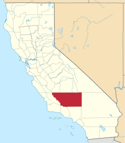
 Location in Kern County and the state of California | |
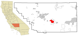
 Bear Valley Springs Location in the United States | |
| Coordinates: 35°9.5′N 118°37.7′W / 35.1583°N 118.6283°WCoordinates: 35°9.5′N 118°37.7′W / 35.1583°N 118.6283°W | |
| Country |
|
| State |
|
| County | Kern |
| Government | |
| • State senator | Jean Fuller (R)[1] |
| • Assemblymember | Vince Fong (R)[1] |
| • U. S. rep. | Kevin McCarthy (R)[2] |
| Area[3] | |
| • Total | 41.551 sq mi (107.615 km2) |
| • Land | 41.485 sq mi (107.445 km2) |
| • Water | 0.066 sq mi (0.170 km2) 0.16% |
| Elevation[4] | 4,121 ft (1,256 m) |
| Population (2010) | |
| • Total | 5,172 |
| • Density | 120/sq mi (48/km2) |
| Time zone | PST (UTC-8) |
| • Summer (DST) | PDT (UTC-7) |
| ZIP code | 93561 |
| Area code(s) | 661 |
| FIPS code | 06-04734 |
| GNIS feature ID | 1866997 |

Bear Valley Springs is a guarded-gate community in Kern County, California, United States. Bear Valley Springs is in the Tehachapi Mountains and is part of the greater Tehachapi area. The elevation ranges from 4,121 feet (1,256 m) to 6,934 feet (Bear Mountain). The population fluctuates between a low during the winter months when snow is common, to a high in the summer months when it's elevation keeps it much cooler than surrounding areas and major cities. The population was 5,172 at the 2010 census, up from 4,232 at the 2000 census. For statistical purposes, the United States Census Bureau has defined Bear Valley Springs as a census-designated place (CDP). The census definition of the area may not precisely correspond to local understanding of the area with the same name.
History
While the nation had pushed to the western coast, the land the Fickert family settled in 1869 was still isolated and remote. For centuries, it had been the realm of Native Americans. Over the years, after purchasing squatter's rights to 160 acres (0.65 km2), the Fickerts expanded their holdings until, by the 1900s their ranch encompassed a vast region of 25,000 acres (100 km2).
By 1959, the last of the immediate Fickert family were gone, joining their kin who had gone before in the tiny family cemetery just up the hill from the main house.
Dart Resorts purchased the ranch, from the Fickert heirs. Resource Ecology Associates was employed by Dart to plan and maintain the original natural value of the property, including wildlife. Bear Valley Springs was born.
The first sales of property were in late 1970 with a full sales team starting January 1971. The project was sold out in November 1977. The Bear Valley Springs Community Services District was formed to act as a nonprofit organization for management and maintenance of the water, roads, and police protection.[5] The Bear Valley Springs Property Owners Association was formed to administer the amenity package. Together they insure the upkeep of the facilities of Bear Valley Springs.[6]
The original concept was a second home destination resort where families could come to spend a weekend or longer and have a complete amenities package. The concept changed from second homes to full-time residents, approximately 3,700 homes.[7] Former President Ronald Reagan bought a ranch in BVS. A number of athletes and TV/movie stars have made BVS their home.
Geography
Bear Valley Springs is located at 35°09.5′N 118°37.7′W / 35.1583°N 118.6283°W.[4]
According to the United States Census Bureau, the CDP has a total area of 41.6 square miles (108 km2), of which, 41.5 square miles (107 km2) of it is land and 0.07 square miles (0.18 km2) of it (0.16%) is water.
Climate
According to the Köppen Climate Classification system, Bear Valley Springs has a semi-arid climate, abbreviated "BSk" on climate maps.[8]
Annual climate specifics can be found at
Demographics
2010
The 2010 United States Census[9] reported that Bear Valley Springs had a population of 5,172. The population density was 124.5 people per square mile (48.1/km²). The racial makeup of Bear Valley Springs was 4,776 (92.3%) White, 74 (1.4%) African American, 46 (0.9%) Native American, 57 (1.1%) Asian, 3 (0.1%) Pacific Islander, 89 (1.7%) from other races, and 127 (2.5%) from two or more races. Hispanic or Latino of any race were 399 persons (7.7%).
The Census reported that 5,171 people (100% of the population) lived in households, 1 (0%) lived in non-institutionalized group quarters, and 0 (0%) were institutionalized.
There were 2,124 households, out of which 571 (26.9%) had children under the age of 18 living in them, 1,467 (69.1%) were opposite-sex married couples living together, 103 (4.8%) had a female householder with no husband present, 54 (2.5%) had a male householder with no wife present. There were 44 (2.1%) unmarried opposite-sex partnerships, and 16 (0.8%) same-sex married couples or partnerships. 429 households (20.2%) were made up of individuals and 214 (10.1%) had someone living alone who was 65 years of age or older. The average household size was 2.43. There were 1,624 families (76.5% of all households); the average family size was 2.79.
The population was spread out with 1,068 people (20.6%) under the age of 18, 246 people (4.8%) aged 18 to 24, 684 people (13.2%) aged 25 to 44, 1,941 people (37.5%) aged 45 to 64, and 1,233 people (23.8%) who were 65 years of age or older. The median age was 51.0 years. For every 100 females there were 99.2 males. For every 100 females age 18 and over, there were 94.8 males.
There were 2,729 housing units at an average density of 65.7 per square mile (25.4/km²), of which 1,860 (87.6%) were owner-occupied, and 264 (12.4%) were occupied by renters. The homeowner vacancy rate was 4.6%; the rental vacancy rate was 10.5%. 4,470 people (86.4% of the population) lived in owner-occupied housing units and 701 people (13.6%) lived in rental housing units.
2000
As of the census[10] of 2000, there were 4,232 people, 1,586 households, and 1,329 families residing in the CDP. The population density was 101.9 people per square mile (39.4/km²). There were 2,147 housing units at an average density of 51.7 per square mile (20.0/km²). The racial makeup of the CDP was 89.89% White, 1.37% Black or African American, 0.31% Native American, 0.71% Asian, 0.07% Pacific Islander, 2.95% from other races, and 4.70% from two or more races. 7.84% of the population were Hispanic or Latino of any race.
There were 1,586 households out of which 32.2% had children under the age of 18 living with them, 76.9% were married couples living together, 4.0% had a female householder with no husband present, and 16.2% were non-families. 13.6% of all households were made up of individuals and 6.6% had someone living alone who was 65 years of age or older. The average household size was 2.67 and the average family size was 2.93.
In the CDP the population was spread out with 26.5% under the age of 18, 3.1% from 18 to 24, 22.3% from 25 to 44, 29.3% from 45 to 64, and 18.8% who were 65 years of age or older. The median age was 44 years. For every 100 females there were 96.2 males. For every 100 females age 18 and over, there were 94.3 males.
The median income for a household in the CDP was $61,169, and the median income for a family was $64,583. Males had a median income of $61,834 versus $31,591 for females. The per capita income for the CDP was $27,388. About 5.4% of families and 7.2% of the population were below the poverty line, including 10.3% of those under age 18 and 7.0% of those age 65 or over.
References
- 1 2 "Statewide Database". Regents of the University of California. Retrieved May 16, 2015.
- ↑ "California's 23rd Congressional District - Representatives & District Map". Civic Impulse, LLC.
- ↑ "2010 Census U.S. Gazetteer Files – Places – California". United States Census Bureau.
- 1 2 U.S. Geological Survey Geographic Names Information System: Bear Valley Springs, California
- ↑ "What is a Community Services District?" (PDF). California Tax Data. Archived from the original (PDF) on 23 March 2016. Retrieved 27 September 2016.
- ↑ Burch IV, J.W. (September 23, 2016). "BVCSD to close post office, outsource dispatch to balance budget". Tehachapi News. Retrieved 27 September 2016.
- ↑ "Bear Valley Springs". The History of Bear Valley Springs. Solveig A. Thompson. Retrieved 27 September 2016.
- ↑ Climate Summary for Bear Valley Springs, California
- ↑ "2010 Census Interactive Population Search: CA - Bear Valley Springs CDP". U.S. Census Bureau. Retrieved July 12, 2014.
- ↑ "American FactFinder". United States Census Bureau. Archived from the original on 2013-09-11. Retrieved 2008-01-31.