County Dublin
| County Dublin Contae Bhaile Átha Cliath | ||
|---|---|---|
| ||
|
Motto: Beart do réir ár mbriathar (Irish) "Action to match our speech" | ||
 | ||
| Country | Ireland | |
| Dáil Éireann |
Dublin Bay North Dublin Bay South Dublin Central Dublin Fingal Dublin Mid-West Dublin North-West Dublin Rathdown Dublin South-Central Dublin South-West Dublin West Dún Laoghaire | |
| EU Parliament | Dublin | |
| Province | Leinster | |
| Area | ||
| • Total | 922 km2 (356 sq mi) | |
| Area rank | 30th | |
| Population (2016) | 1,345,402 | |
| • Rank | 1st | |
| Vehicle index mark code | D | |

County Dublin (Irish: Contae Bhaile Átha Cliath[1] or Contae Átha Cliath) is a former county in Ireland. It is conterminous with the Dublin Region and is in the province of Leinster. It is named after the city of Dublin, which is the regional capital and the capital city of Ireland. County Dublin was one of the first parts of Ireland to be shired by John, King of England following the Norman invasion of Ireland.
Prior to 1994 County Dublin was also an administrative unit covering the whole county outside of Dublin City Council. In 1994 Dublin County Council was abolished and replaced with three separate administrative county councils: Dún Laoghaire–Rathdown, Fingal and South Dublin. The total population of the three aforementioned counties and Dublin city was 1,345,402 according to the census of 2016.[2]
Since the abolition of the Dublin Regional Assembly by statutory instrument No. 573/2014,[3][4] the Eurostat statistical region known as "Dublin Region" falls under the remit of the wider Eastern and Midland Regional Authority.[5]
Local government and politics
Local authorities
There are four local authorities whose remit collectively encompasses the geographic area of the county and city of Dublin. These are Dublin City Council, South Dublin County Council, Dún Laoghaire-Rathdown County Council and Fingal County Council.

| Name | Area | Population[6] | |
|---|---|---|---|
| 1 | Dublin City | 114.99 km2 (44.40 sq mi) | 553,165 |
| 2 | Dún Laoghaire–Rathdown | 127.31 km2 (49.15 sq mi) | 217,274 |
| 3 | Fingal | 454.60 km2 (175.52 sq mi) | 296,214 |
| 4 | South Dublin | 222.74 km2 (86.00 sq mi) | 278,749 |
Prior to the enactment of the Local Government (Dublin) Act 1993, the county was a unified whole even though it was administered by two local authorities - Dublin County Council and Dublin Corporation. Since the enactment of the Local Government Act 2001 in particular, the geographic area of the county has been divided between three entities at the level of "county" and a further entity at the level of "city". They rank equally as first level local administrative units of the NUTS 3 Dublin Region for Eurostat purposes. There are 34 LAU 1 entities in the Republic of Ireland. Each local authority is responsible for certain local services such as sanitation, planning and development, libraries, the collection of motor taxation, local roads and social housing.
Dublin County Council (which did not include the county borough of Dublin) was abolished in 1994 and the area divided among the administrative counties of Dún Laoghaire–Rathdown, Fingal and South Dublin each with its county seat. To these areas may be added the area of Dublin city which collectively comprise the Dublin Region[7] (Réigiúin Átha Cliath) and come under the remit of the Dublin Regional Authority.
The area lost its administrative county status in 1994, with Section 9 Part 1(a) of the Local Government (Dublin) Act, 1993 stating that "the county shall cease to exist."[8][9] In discussing the legislation to dissolve Dublin County Council, Avril Doyle TD said, "The Bill before us today effectively abolishes County Dublin, and as one born and bred in these parts of Ireland I find it rather strange that we in this House are abolishing County Dublin. I am not sure whether Dubliners realise that that is what we are about today, but in effect that is the case."[10]
The county is part of the Dublin constituency for the purposes of European elections. For elections to Dáil Éireann, the area of the county is currently (2016) divided into eleven constituencies: Dublin Bay North, Dublin Bay South, Dublin Central, Dublin Fingal, Dublin Mid-West, Dublin North-West, Dublin Rathdown, Dublin South-Central, Dublin South-West, Dublin West, and Dún Laoghaire. Together they return 44 deputies (TDs) to the Dáil.
Despite the legal status of the Dublin Region, the term "County Dublin" is still in common usage. Many organisations and sporting teams continue to organise on a "County Dublin" or "Dublin Region" basis. The area formerly known as "County Dublin" is now defined in legislation solely as the "Dublin Region" under the Local Government Act, 1991 (Regional Authorities) (Establishment) Order, 1993,[7] and this is the terminology officially used by the four Dublin administrative councils in press releases concerning the former county area. The term Greater Dublin Area, which might consist of some or all of the Dublin Region along with counties of Kildare, Meath and Wicklow, has no legal standing.
Dublin Region

The Dublin Region is a NUTS Level III region of Ireland. The region is one of eight regions of the Republic of Ireland for the purposes of Eurostat statistics. Its NUTS code is IE021. It is co-extensive with the old county. The regional capital is Dublin City which is also the national capital.[11]
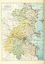
The latest Ordnance Survey Ireland "Discovery Series" (Third Edition 2005) 1:50,000 map of the Dublin Region, Sheet 50, shows the boundaries of the city and three surrounding counties of the region. Extremities of the Dublin Region, in the north and south of the region, appear in other sheets of the series, 43 and 56 respectively.
.jpg)
Media

- Local radio stations include 98FM, FM104, 103.2 Dublin City FM, Q102, SPIN 1038, Sunshine 106.8, TXFM, Raidió Na Life and Radio Nova.
- Local newspapers include The Echo, Northside People, Southside People and the Liffey Champion.
Most of the area can receive the five main UK television channels on analogue television as well as the main Irish channels, along with Sky TV and Virgin Media Ireland cable television.
Transport
- Road: The major roads are the N2, N3, N4 and N7 national primary roads, and the M1, M11 and M50 motorways.
- Heavy rail: The InterCity and Commuter rail services (Iarnród Éireann).
- Light rail: The Luas tram system serving Dublin City and its southern and western suburbs.
- Rapid transit: The DART and the proposed Dublin Metro line.
- Port: Dublin Port and Dún Laoghaire Harbour.
- Air: Dublin International Airport.
Economy
The economy of County Dublin was identified as being the powerhouse behind the Celtic Tiger, a period of strong economic growth of the state. This resulted in the economy of the county expanding by almost 100% between the early 1990s and 2007. This growth resulted from incoming high-value industries, such as financial services and software manufacturing, as well as low-skilled retail and domestic services, which caused a shift away from older manufacturing-industry.[11] This change saw high unemployment in the 1980s and early 1990s which resulted in damage to the capitals social structure.[11]
[12] According to Eurostat figures for 2012, the region has GDP of €72.384 bn and a GDP per capita of €57,200 the highest on the island of Ireland (the second highest is Cork with €48,500)
Transport
County Dublin is the main transport node of Ireland,[11] and contains one international airport, Dublin Airport. It is also served by two main seaports, Dún Laoghaire port and Dublin Port, which is just located outside of the city center. The two main train stations are Dublin Heuston and Dublin Connolly, both of which serve intercity trains.
Demographics
According to the 2006 census, County Dublin had a population of 1,187,176, which constitutes 30% of the national population. This was an increase of 9.5% on 2002 figures. Its population density was 1,218/km². The population of Dublin City, was 506,211.[11]
The median age of the population of the county in the 2006 census was 35.6 years, with 62% of people aged between 20–64 years old. Net migration to the county between 2002 and 2006 was 48,000, with a natural increase of 33,000 people.[11]
There are 10,469 Irish speakers in County Dublin attending the 31 Gaelscoils (Irish language primary schools) and eight Gaelcholáiste (Irish language secondary schools).[13] There may be up to another 10,000 Irish speakers from the Gaeltacht living and working in Dublin also.
Urban areas
A list of the largest urban areas (those with over 1,000 inhabitants) in County Dublin. Administrative county seats are shown in bold.
| Rank | Urban area | County | Population (2011 census) |
|---|---|---|---|
| 1 | Dublin | Dublin City, Dún Laoghaire–Rathdown, Fingal, South Dublin |
1,270,603 |
| 2 | Tallaght | South Dublin | 71,504 |
| 3 | Blanchardstown | Fingal | 68,156 |
| 4 | Swords | Fingal | 42,738 |
| 5 | Dún Laoghaire | Dún Laoghaire-Rathdown | 38,761 |
| 6 | Balbriggan | Fingal | 19,960 |
| 7 | Malahide | Fingal | 15,846 |
| 8 | Skerries | Fingal | 9,671 |
| 9 | Portmarnock | Fingal | 9,285 |
| 10 | Rush | Fingal | 9,231 |
| 11 | Donabate | Fingal | 8,730 |
| 12 | Lusk | Fingal | 7,022 |
Towns and suburbs
| Historical population | ||
|---|---|---|
| Year | Pop. | ±% |
| 1500 | 14,755 | — |
| 1510 | 23,471 | +59.1% |
| 1550 | 21,678 | −7.6% |
| 1580 | 20,345 | −6.1% |
| 1585 | 20,224 | −0.6% |
| 1600 | 24,556 | +21.4% |
| 1610 | 12,567 | −48.8% |
| 1653 | 18,847 | +50.0% |
| 1659 | 21,827 | +15.8% |
| 1672 | 55,678 | +155.1% |
| 1680 | 101,414 | +82.1% |
| 1690 | 145,219 | +43.2% |
| 1700 | 161,234 | +11.0% |
| 1710 | 173,690 | +7.7% |
| 1720 | 205,111 | +18.1% |
| 1725 | 212,670 | +3.7% |
| 1735 | 209,785 | −1.4% |
| 1745 | 217,666 | +3.8% |
| 1755 | 235,799 | +8.3% |
| 1765 | 244,103 | +3.5% |
| 1771 | 255,297 | +4.6% |
| 1775 | 271,475 | +6.3% |
| 1781 | 285,799 | +5.3% |
| 1788 | 291,433 | +2.0% |
| 1790 | 297,644 | +2.1% |
| 1801 | 300,345 | +0.9% |
| 1811 | 305,766 | +1.8% |
| 1813 | 311,798 | +2.0% |
| 1816 | 318,760 | +2.2% |
| 1821 | 335,892 | +5.4% |
| 1831 | 380,167 | +13.2% |
| 1841 | 372,773 | −1.9% |
| 1851 | 405,147 | +8.7% |
| 1861 | 410,252 | +1.3% |
| 1871 | 405,262 | −1.2% |
| 1881 | 418,910 | +3.4% |
| 1891 | 419,216 | +0.1% |
| 1901 | 448,206 | +6.9% |
| 1911 | 477,196 | +6.5% |
| 1926 | 505,654 | +6.0% |
| 1936 | 586,925 | +16.1% |
| 1946 | 636,193 | +8.4% |
| 1951 | 693,022 | +8.9% |
| 1956 | 705,781 | +1.8% |
| 1961 | 718,332 | +1.8% |
| 1966 | 795,047 | +10.7% |
| 1971 | 852,219 | +7.2% |
| 1979 | 983,683 | +15.4% |
| 1981 | 1,003,164 | +2.0% |
| 1986 | 1,021,449 | +1.8% |
| 1991 | 1,025,304 | +0.4% |
| 1996 | 1,058,264 | +3.2% |
| 2002 | 1,122,821 | +6.1% |
| 2006 | 1,187,176 | +5.7% |
| 2011 | 1,270,603 | +7.0% |
| 2016 | 1,345,402 | +5.9% |
| [14][15][16][17][18][19] | ||
- Adamstown
- Artane
- Ashtown
- Balbriggan
- Baldoyle
- Balgriffin
- Ballinteer
- Ballsbridge
- Ballyboden
- Ballybrack
- Ballybough
- Ballyfermot
- Ballygall
- Ballymount
- Ballymun
- Ballyroan
- Balrothery
- Bayside
- Beaumont
- Belfield
- Blackrock
- Blanchardstown
- Bluebell
- Booterstown
- Brittas
- Broadstone
- Ballyboughal
- Cabinteely
- Cabra
- Carrickmines
- Castleknock
- Chapelizod
- Cherrywood
- Churchtown
- Clondalkin
- Clonsilla
- Clonskeagh
- Clontarf
- Coolmine
- Coolock
- Corduff
- Cornelscourt
- Crumlin
- Dalkey
- Darndale
- Dartry
- Deansgrange
- Dollymount
- Dolphin's Barn
- Donabate
- Donaghmede
- Donnybrook
- Donnycarney
- Drimnagh
- Drumcondra
- Dún Laoghaire
- Dundrum
- East Wall
- Edmondstown
- Fairview
- Finglas
- Firhouse
- Foxrock
- Garristown
- Glasnevin
- Glasthule
- Glencullen
- Glenageary
- Goatstown
- Grangegorman
- Harold's Cross
- Howth
- Inchicore
- Irishtown
- Islandbridge
- Jobstown
- Kill O' The Grange
- Kilbarrack
- Killester
- Killiney
- Kilmacud
- Kilmainham
- Kilnamanagh
- Kilternan
- Kimmage
- Kinsealy
- Knocklyon
- Leopardstown
- Loughlinstown
- Lucan
- Lusk
- Malahide
- Marino
- Milltown
- Monkstown
- Mount Merrion
- Mulhuddart
- Newcastle
- Naul
- Oldbawn
- Ongar
- Palmerstown
- Phibsborough
- Portmarnock
- Portobello
- Raheny
- Ranelagh
- Rathcoole
- Rathfarnham
- Rathgar
- Rathmichael
- Rathmines
- Rialto
- Ringsend
- Rush
- Saggart
- Sallynoggin
- Sandycove
- Sandyford
- Sandymount
- Santry
- Shankill
- Skerries
- Smithfield
- Stepaside
- Stillorgan
- Stoneybatter
- Sutton
- Swords
- Tallaght
- Templeogue
- Terenure
- The Coombe
- Tyrrelstown
- Walkinstown
- Whitechurch
- Whitehall
- Windy Arbour
See also
- For the baronial sub-divisions of the old county
- List of abbeys and priories in the Republic of Ireland (County Dublin)
- List of mountains and hills of County Dublin
- List of rivers in County Dublin
- List of schools in County Dublin
- List of subdivisions of County Dublin
- List of townlands of County Dublin
- List of regions of the Republic of Ireland
- Greater Dublin Area
References
- ↑ Logainm.ie
- ↑ Population and Actual and Percentage Change 2011 to 2016 by Sex, Province County or City, CensusYear and Statistic, Central Statistics Office. Retrieved 16 Jul 2016
- ↑ http://www.irishstatutebook.ie/2014/en/si/0228.html
- ↑ Statutory Instrument 573/2014
- ↑ "Eastern and Midland Regional Assembly". Eastern & Midland Regional Assembly. Retrieved 2016-09-30.
- ↑ CD101: Actual and Percentage Change in Population by Sex, Aggregate Town or Rural Area, Province County or City, CensusYear and Statistic, Central Statistics Office. Retrieved 6 Dec 2015
- 1 2 "Local Government Act, 1991 (Regional Authorities) (Establishment) Order, 1993". Retrieved 31 July 2009.
- ↑ Act of the Oireachtas: Local Government (Dublin) Act, 1993 (Section 9 Part 1(a))
- ↑ Local Government (Dublin) Act, 1993 Section 2 specifies: "the county", in relation to any time before the establishment day, means the administrative county of Dublin.
- ↑ Dáil Éireann: Parliamentary Debates (3 November 1993)
- 1 2 3 4 5 6 Irish Region Office - Regions of Ireland: Dublin Region
- ↑ http://appsso.eurostat.ec.europa.eu/nui/submitViewTableAction.do
- ↑ "Oideachas Trí Mheán na Gaeilge in Éirinn sa Ghalltacht 2010-2011" (PDF) (in Irish). gaelscoileanna.ie. 2011. Retrieved 9 January 2012.
- ↑ For 1653 and 1659 figures from Civil Survey Census of those years, Paper of Mr Hardinge to Royal Irish Academy 14 March 1865.
- ↑ "Census for post 1821 figures".
- ↑ "Histpop - The Online Historical Population Reports Website homepage". Retrieved 4 December 2010.
- ↑ "Northern Ireland Census of Population". NISRA. Archived from the original on 17 February 2012. Retrieved 4 December 2010.
- ↑ Lee, JJ (1981). "On the accuracy of the Pre-famine Irish censuses". In Goldstrom, J. M.; Clarkson, L. A. Irish Population, Economy, and Society: Essays in Honour of the Late K. H. Connell. Oxford, England: Clarendon Press.
- ↑ Mokyr, Joel; O Grada, Cormac (November 1984). "New Developments in Irish Population History, 1700-1850". The Economic History Review. 37 (4): 473–488. doi:10.1111/j.1468-0289.1984.tb00344.x.
External links
| Wikimedia Commons has media related to County Dublin. |
| Wikivoyage has a travel guide for County Dublin. |
| Wikinews has news related to: |
- Dublin Regional Authority
- Architecture of County Dublin
- Civil parishes of County Dublin, from Ireland.com
- Score for 'Quality of Life' in County Dublin
- Gaelscoil stats
- Que ver en Dublín
 |
County Meath |
| ||
| County Meath County Kildare |
|
Irish Sea | ||
| ||||
| | ||||
| County Wicklow |
Divisions of County Dublin | ||
|---|---|---|
| Cities | | |
| Counties | ||
| Districts | ||
| See also | ||
|  | |
| ||
The counties are listed per province | ||
 | ||
| ||
Coordinates: 53°25′N 6°15′W / 53.417°N 6.250°W