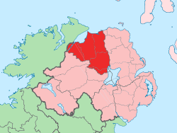
County Londonderry
| County Londonderry Contae Dhoire Coontie Lunnonderrie | ||
|---|---|---|
| ||
|
Motto: Auxilium A Domino (Latin) "Help comes from the Lord" | ||
 | ||
| Province | Ulster | |
| Country | Northern Ireland | |
| Sovereign state | United Kingdom | |
| County town | Coleraine | |
| Area | ||
| • Total | 2,074 km2 (801 sq mi) | |
| Area rank | 15th | |
| Population (2011) | 247,132 | |
| • Rank | 6th[1] | |
| Contae Dhoire[2] is the Irish name; Coontie Lunnonderrie is its name in Ulster Scots.[3] | ||
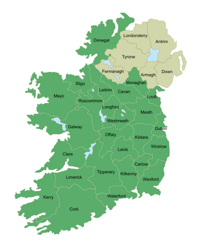
County Londonderry, also known as County Derry (Irish: Contae Dhoire, Ulster Scots: Coontie Lunnonderrie), is one of the six counties of Northern Ireland. Adjoining the north-west shore of Lough Neagh, the county covers an area of 2,074 km² (801 sq mi) and has a population of about 247,132. It is also one of the thirty-two traditional counties of Ireland, as well as part of the historic province of Ulster.
Since 1981, it has become one of four counties in Northern Ireland that has a Catholic majority (55.56% according to the 2001 Census[4]), with 57% of the Catholic population residing within Derry City Council.[4] The county flower is the Purple Saxifrage.[5]
Name
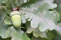
The place name Derry is an anglicisation of the old Irish Daire[6] (Modern Irish Doire[7]), meaning "oak-grove" or "oak-wood".[8]
As with the city, its name is subject to the Derry/Londonderry name dispute, with the form "Londonderry" generally preferred by unionists and "Derry" by nationalists.[9][10][11][12][13] British authorities use the name "Londonderry", while "Derry" is used by the Republic of Ireland.
History

Pre-historic
Mountsandel located near Coleraine in County Londonderry is "perhaps the oldest recorded settlement within Ireland".[14][15]
County Coleraine and the Plantation of Ulster
At an early period, what became the county of Coleraine was inhabited by the O'Cahans, who were tributary to the O'Neills. Towards the close of the reign of Elizabeth I their territory was seized by England, with the purpose of checking the power of the O'Neills, and was made the county of Coleraine, named after the regional capital.
A short description of County Coleraine is giving in Harris's Hibernica, and also from Captain Pynnar's Survey of the Escheated Counties of Ulster, Anno 1618:
| “ |
The county of Coleraine,* otherwise called O'Cahan's country, is divided, as Tyrone, by ballyboes and doth contain, as appeareth by the survey, 547 ballyboes, or 34,187 acres, every ballyboe containing 60 acres or thereabouts. |
” |
On 2 March 1613, James I granted a charter to the The Honourable The Irish Society to undertake the plantation of a new county.[16] This county was named Londonderry, a combination of London (in reference to the Livery Companies of the Irish Society) and Derry (then name of the city). This charter declared that the "City of Londonderry" and everything contained within the new county:
| “ |
shall be united, consolidated, and from hence-forth for ever be one entire County of itself, distinct and separate from all our Counties whatsoever within our Kingdom of Ireland-and from henceforth for ever be named, accounted and called, the County of Londonderry.[16] |
” |
This new county would comprise the then County Coleraine—which consisted of the baronies of Tirkeeran, Coleraine, and Keenaght—and at the behest of The Irish Society the following additional territory was added: all but the south-west corner of the barony of Loughinsholin, then a part of County Tyrone, as it had sufficient wood for construction; the North East Liberties of Coleraine, which was part of County Antrim and the City of Londonderry and its Liberties, which were in County Donegal, so that they could control both banks of the River Foyle and River Bann.[16][17][18]
The Irish Society was made up of the twelve main livery companies of London, which themselves were composed of various guilds. Whilst The Irish Society as a whole was given possession of the city of Londonderry and Coleraine, the individual companies were each granted an estimated 3,210 acres throughout the county. These companies and the sites of their headquarters were:[19][20]
- Clothworkers, based at Killowen and Clothworker's Hall (present-day Articlave) in the barony of Coleraine
- Drapers, based at Draper's Hall, later called Drapers Town (present-day Moneymore) in the barony of Loughinsholin.[21]
- Fishmongers, based at Artikelly and Fishermonger's Hall (present-day Ballykelly) in the barony of Keenaght
- Goldsmiths, based at Goldsmith's Hall (present-day Newbuildings) in the barony of Tirkeeran
- Grocers, based at Grocer's Hall, alias Muff (present-day Eglinton) in the barony of Tirkeeran
- Haberdashers, based at Habberdasher's Hall (present-day Ballycastle) in the barony of Keenaght
- Ironmongers, based at Ironmonger's Hall (present-day townland of Agivey) in the barony of Coleraine
- Mercers, based at Mercer's Hall (present-day townland of Movanagher) in the barony of Coleraine
- Merchant Taylors, based at Merchant Taylor's Hall (present-day Macosquin) in the barony of Coleraine
- Salters, based at Salter's Hall (present-day Magherafelt) and Salters Town in the barony of Loughinsholin
- Skinners, based at Skinner's Hall (present-day Dungiven) in the barony of Keenaght
- Vintners, based at Vintner's Hall, later called Vintner's Town (present-day Bellaghy) in the barony of Loughinsholin
19th century
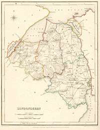
As a result of the Local Government (Ireland) Act 1898, the city was detached from the county for administrative purposes, becoming a separate county borough from 1899. The county town of County Londonderry, and seat of the Londonderry County Council until its abolition in 1973, was therefore moved to the town of Coleraine.
Demographics
| Historical population | ||
|---|---|---|
| Year | Pop. | ±% |
| 1653 | 6,102 | — |
| 1659 | 7,102 | +16.4% |
| 1821 | 193,869 | +2629.8% |
| 1831 | 222,012 | +14.5% |
| 1841 | 222,174 | +0.1% |
| 1851 | 192,022 | −13.6% |
| 1861 | 184,209 | −4.1% |
| 1871 | 173,906 | −5.6% |
| 1881 | 164,991 | −5.1% |
| 1891 | 152,009 | −7.9% |
| 1901 | 144,404 | −5.0% |
| 1911 | 140,625 | −2.6% |
| 1926 | 139,693 | −0.7% |
| 1937 | 142,736 | +2.2% |
| 1951 | 155,540 | +9.0% |
| 1961 | 165,298 | +6.3% |
| 1966 | 174,658 | +5.7% |
| 1971 | 183,094 | +4.8% |
| 1981 | 197,278 | +7.7% |
| 1991 | 213,035 | +8.0% |
| 2001 | 235,864 | +10.7% |
| [22][23][24][25][26][27] | ||
Geography and places of interest

The highest point in the county is the summit of Sawel Mountain (678 metres (2,224 ft)) on the border with County Tyrone. Sawel is part of the Sperrin Mountains, which dominate the southern part of the county. To the east and west, the land falls into the valleys of the Bann and Foyle rivers respectively; in the south-east, the county touches the shore of Lough Neagh, which is the largest lake in Ireland; the north of the county is distinguished by the steep cliffs, dune systems, and remarkable beaches of the Atlantic coast.
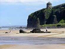
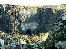
The county is home to a number of important buildings and landscapes, including the well-preserved 17th-century city walls of Derry; the National Trust–owned Plantation estate at Springhill; Mussenden Temple with its spectacular views of the Atlantic; the dikes, artificial coastlines and the noted bird sanctuaries on the eastern shore of Lough Foyle; and the visitor centre at Bellaghy Bawn, close to the childhood home of Nobel laureate Seamus Heaney. In the centre of the county are the old-growth deciduous forests at Banagher and Ness Wood, where the Burntollet River flows over the highest waterfalls in Northern Ireland.
Subdivisions
- Baronies
- Coleraine
- Keenaght
- North East Liberties of Coleraine
- North West Liberties of Londonderry
- Loughinsholin
- Tirkeeran
- Parishes
- Townlands
Settlements
- Cities
(population of 75,000 or more with a cathedral)
- Large towns
(population of 18,000 or more and under 75,000 at 2001 Census)[28]
- Medium towns
(population of 10,000 or more and under 18,000 at 2001 Census)[28]
- Small towns
(population of 4,500 or more and under 10,000 at 2001 Census)[28]
- Intermediate settlements
(population of 2,250 or more and under 4,500 at 2001 Census)[28]
- Culmore (part of Derry Urban Area)
- Dungiven
- Eglinton
- Maghera
- Newbuildings (part of Derry Urban Area)
- Villages
(population of 1,000 or more and under 2,250 at 2001 Census)[28]
- Ballykelly
- Bellaghy
- Castledawson
- Castlerock
- Claudy
- Draperstown
- Garvagh
- Greysteel
- Kilrea
- Moneymore
- Strathfoyle (part of Derry Urban Area)
- Small villages or hamlets
(population of less than 1,000 at 2001 Census)[28]
Administration
In 1973 counties ceased to be a unit of administration within Northern Ireland, being replaced by district councils. These councils were: Derry City Council, Limavady Borough Council, and Magherafelt District Council, most of Coleraine Borough Council, and part of Cookstown District Council. After a reduction in the number of councils in Northern Ireland in 2011, County Londonderry is divided into three cross-county councils: Causeway Coast and Glens, Derry and Strabane, and Mid-Ulster District.
Railways
Translink provides a Northern Ireland Railways service in the county, linking Londonderry Waterside railway station to Coleraine railway station (with a branch to Portrush on the Coleraine–Portrush railway line) and onwards into County Antrim to Belfast Central and Belfast Great Victoria Street on the Belfast-Derry railway line.
There is also the Foyle Valley Railway, a museum in Derry with some rolling stock from both the County Donegal Railway and the Londonderry and Lough Swilly Railway, and is located on the site of the former Londonderry Foyle Road railway station. The Londonderry and Lough Swilly Railway continued as a private bus company based in the city but operating predominantly in County Donegal until it closed in 2014. Bus services are now provided by Ulsterbus.
Education
Government-funded education up to secondary school level is administered by
- Western Education and Library Board: Derry, Limavady
- North Eastern Education and Library Board: Coleraine, Magherafelt
- Southern Education and Library Board: Cookstown
For Catholic grant-maintained schools administration is by the Derry Diocesan Education Office.
Two major centres of the University of Ulster are in the county, including its headquarters at Coleraine and the Magee Campus in Derry.
Sport
In Gaelic games, the GAA county of Derry is more or less coterminous with the former administrative county of Londonderry, although teams from the neighbouring counties of Tyrone, Donegal and Antrim have occasionally played in Derry competitions, and vice versa. The Derry teams wear the colours red and white. There are many club teams competing in up to five leagues and three championships. The county team has won one All-Ireland Senior Football Championship (in 1993) and five National League titles. Hurling is also widely played but is not as popular as football. However, the county team is generally regarded as one of the top hurling sides in Ulster and in 2006 won the Nicky Rackard Cup – the third tier hurling competition in Ireland.
In association football, the NIFL Premiership, which operates as the top division, has two teams in the county: Coleraine F.C. and Institute F.C., with Limavady United F.C., Moyola Park F.C., Portstewart F.C. and Tobermore United F.C. competing in the NIFL Championship, which operates as levels two and three. Derry City F.C. play in the Premier Division of the League of Ireland after leaving the Northern Ireland structures in 1985, having resigned from the Irish Football League at the height of the Troubles because of not being allowed play their home games at the Brandywell due to security concerns from other clubs.
The Northern Ireland Milk Cup was established in 1983 and is regarded as one of the most prestigious youth football tournaments in Europe and the world.[29][30][31][32] The competition is based at Coleraine and involves several other towns and villages in the county – Limavady, Portstewart and Castlerock – and in neighbouring County Antrim – Ballymoney, Portrush, Ballymena and Broughshane. The event, held in the last week of July, has attracted teams from 56 countries around the world including Europe, the USA, Africa, the Far East, South America, the Middle East, Australia, Russia, New Zealand and Canada. Some of the biggest teams in the world have entered including Premiership giants Everton, Liverpool, Manchester United, Chelsea, Tottenham Hotspur as well as top European teams such as Feyenoord, F.C. Porto, FC Barcelona, Benfica, Bayern Munich and Dynamo Kiev.
In rugby union, the county is represented at senior level by Rainey Old Boys Rugby Club, Magherafelt who compete in the Ulster Senior League and All Ireland Division Three. Limavady R.F.C, City of Derry Rugby Club, Londonderry Y.M.C.A and Coleraine Rugby Club all compete in Ulster Qualifying League One.
Cricket is particularly popular in the north-west of Ireland, with 11 of the 20 senior clubs in the North West Cricket Union located in County Londonderry: Limavady, Eglinton, Glendermott, Brigade, Killymallaght, Ardmore, Coleraine, Bonds Glen, Drummond, Creevedonnell and The Nedd.
In rowing, Richard Archibald from Coleraine along with his Irish team-mates qualified for the Beijing 2008 Olympics by finishing second in the lightweight fours final in Poznań, thus qualifying for the Beijing 2008 Olympics. Another Coleraine rower Alan Campbell is a World Cup gold medallist in the single sculls in 2006.
Media
The county currently has four main radio stations:
- BBC Radio Foyle
- Q102.9
- Q97.2
- Six FM (in the south of the county)
See also
- Abbeys and priories in Northern Ireland (County Londonderry)
- List of places in County Londonderry
- List of townlands in County Londonderry
- List of civil parishes of County Londonderry
- Lord Lieutenant of County Londonderry
- High Sheriff of County Londonderry
References
- ↑ Key Statistics Tables 2001 Census combined for Coleraine, Derry, Limavady & Magherafelt.
- ↑ "Northern Ireland" (PDF). Ministry of Defence (United Kingdom). Retrieved 28 October 2010.
- ↑ Banagher and Boveagh Churches Archived 30 August 2011 at the Wayback Machine. Department of the Environment.
- 1 2 2001 Census Statistics
- ↑ County flowers in Britain www.plantlife.org.uk
- ↑ Delanoy, Werner; et al. (2007). Towards a Dialogic Anglistics. LIT Verlag. p. 38. ISBN 978-3-8258-0549-4.
- ↑ "doire". téarma.ie – Dictionary of Irish Terms. Foras na Gaeilge and Dublin City University. Retrieved 18 November 2016.
- ↑ Blackie, Christina (2010). Geographical Etymology. Marton Press. p. 61. ISBN 978-1-4455-8286-3.
- ↑ Centre for European Policy Studies, accessed 6 October 2007
- ↑ "The Walled City Experience". Northern Ireland Tourist Board. Retrieved 4 September 2008.
- ↑ BBC News: Court to Rule on City Name 7 April 2006
- ↑ City name row lands in High Court BBC News
- ↑ Derry City Council: Re Application for Judicial Review [2007] NIHC 5 (QB)
- ↑ A.E.P. Collins (1983), "Excavations at Mount Sandel, Lower Site", Ulster Journal of Archaeology vol. 46 pp1-22. JSTOR preview.
- ↑ C. Michael Hogan. 2011. Celtic Sea. Encyclopedia of Earth. Eds. P. Saundry & C.J. Cleveland. National Council for Science and the Environment. Washington DC
- 1 2 3 Notes on the Place Names of the Parishes and Townlands of the County of Londonderry, 1925, Alfred Moore Munn, Clerk of the Crown and Peace of the City and County of Londonderry
- ↑ A New History of Ireland, pages 111–112
- ↑ Curl, James Stevens (2001). "The City of London and the Plantation of Ulster". BBCi History Online. Retrieved 10 August 2008.
- ↑ Robinson, Philip (2000). the Plantation of Ulster. Ulster Historical Foundation. ISBN 978-1-903688-00-7.
- ↑ Walter Harris. "Hibernica: or, Some antient places relating to Ireland". Retrieved 30 June 2016.
- ↑ Place Names NI - Moneymore
- ↑ For 1653 and 1659 figures from Civil Survey Census of those years, Paper of Mr Hardinge to Royal Irish Academy 14 March 1865.
- ↑ Census for post 1821 figures.
- ↑ http://www.histpop.org
- ↑ NISRA – Northern Ireland Statistics and Research Agency (c) 2013 Archived 17 February 2012 at the Wayback Machine.. Nisranew.nisra.gov.uk (27 September 2010). Retrieved on 23 July 2013.
- ↑ Lee, JJ (1981). "On the accuracy of the Pre-famine Irish censuses". In Goldstrom, J. M.; Clarkson, L. A. Irish Population, Economy, and Society: Essays in Honour of the Late K. H. Connell. Oxford, England: Clarendon Press.
- ↑ Mokyr, Joel; O Grada, Cormac (November 1984). "New Developments in Irish Population History, 1700–1850". The Economic History Review. 37 (4): 473–488. doi:10.1111/j.1468-0289.1984.tb00344.x.
- 1 2 3 4 5 6 "Statistical classification of settlements". NI Neighbourhood Information Service. Retrieved 23 February 2009.
- ↑ Newsletter.co.uk
- ↑ NI Milk Cup Official Site
- ↑ Manchester United Official Website
- ↑ University of Illinois at Chicago (UIC)
External links
| Wikimedia Commons has media related to County Londonderry. |
| Wikivoyage has a travel guide for County Londonderry. |
 |
Atlantic Ocean | | ||
| County Donegal |
|
County Antrim | ||
| ||||
| | ||||
| County Tyrone |
Lough Neagh |
The counties are listed per province | ||
 | ||
| ||