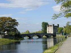
County Kildare
| County Kildare Contae Chill Dara | ||
|---|---|---|
| ||
|
Motto: Meanma agus Misneach (Irish) "Spirit and Courage" | ||
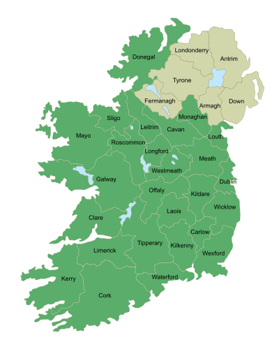
 Location in Ireland | ||
| Coordinates: 53°10′N 6°45′W / 53.167°N 6.750°WCoordinates: 53°10′N 6°45′W / 53.167°N 6.750°W | ||
| Country | Ireland | |
| Province | Leinster | |
| County town | Naas | |
| Government | ||
| • Type | County Council | |
| • Dáil Éireann |
Kildare North Kildare South | |
| • European Parliament | Midlands–North-West | |
| Area | ||
| • Total | 1,695 km2 (654 sq mi) | |
| Area rank | 24th | |
| Population (2016)[1] | 222,130 | |
| • Rank | 7th | |
| Vehicle index mark code | KE | |
| Website |
www | |

County Kildare (Irish: Contae Chill Dara) is a county in Ireland. It is located in the province of Leinster and is part of the Mid-East Region. It is named after the town of Kildare. Kildare County Council is the local authority for the county which has a population of 222,130.[2]
Geography and political subdivisions
Kildare is the 24th largest of Ireland's thirty-two counties in area and seventh largest in terms of population.[3] It is the eighth largest of Leinster's twelve counties in size, and second largest in terms of population. It is bordered by the counties of Carlow, Laois, Meath, Offaly, Dublin and Wicklow. As an inland county, Kildare is a generally lowland region. The county's highest points are the foothills of the Wicklow Mountains bordering to the east. The highest point in Kildare is Cupidstown Hill on the border with Dublin, with the better known Hill of Allen in central Kildare.
Towns and villages
- Allen
- Allenwood
- Ardclough
- Athy
- Ballitore
- Ballymore Eustace
- Calverstown
- Caragh
- Carbury
- Castledermot
- Clane
- Coill Dubh
- Celbridge
- Curragh
- Derrinturn
- Eadestown
- Johnstown
- Kilberry
- Kilcock
- Kilcullen
- Kildangan
- Kill
- Kilmead
- Kilmeage
- Kilteel
- Kildare
- Leixlip
- Lullymore
- Maynooth
- Milltown
- Moone
- Monasterevin
- Narraghmore
- Nurney
- Naas
- Newbridge
- Prosperous
- Rathangan
- Robertstown
- Sallins
- Straffan
- Staplestown
- Suncroft
- Timolin
Physical geography

| Historical population | ||
|---|---|---|
| Year | Pop. | ±% |
| 1500 | 2,887 | — |
| 1510 | 4,112 | +42.4% |
| 1550 | 5,033 | +22.4% |
| 1580 | 6,787 | +34.8% |
| 1585 | 3,454 | −49.1% |
| 1600 | 4,556 | +31.9% |
| 1610 | 8,714 | +91.3% |
| 1653 | 11,983 | +37.5% |
| 1659 | 13,825 | +15.4% |
| 1672 | 54,110 | +291.4% |
| 1788 | 71,570 | +32.3% |
| 1813 | 85,000 | +18.8% |
| 1821 | 99,065 | +16.5% |
| 1831 | 108,424 | +9.4% |
| 1841 | 114,488 | +5.6% |
| 1851 | 95,723 | −16.4% |
| 1861 | 90,946 | −5.0% |
| 1871 | 83,614 | −8.1% |
| 1881 | 75,804 | −9.3% |
| 1891 | 70,206 | −7.4% |
| 1901 | 63,566 | −9.5% |
| 1911 | 66,627 | +4.8% |
| 1926 | 58,028 | −12.9% |
| 1936 | 57,892 | −0.2% |
| 1946 | 64,849 | +12.0% |
| 1951 | 66,437 | +2.4% |
| 1956 | 65,915 | −0.8% |
| 1961 | 64,420 | −2.3% |
| 1966 | 66,404 | +3.1% |
| 1971 | 71,977 | +8.4% |
| 1979 | 97,185 | +35.0% |
| 1981 | 104,122 | +7.1% |
| 1986 | 116,247 | +11.6% |
| 1991 | 122,656 | +5.5% |
| 1996 | 134,992 | +10.1% |
| 2002 | 163,944 | +21.4% |
| 2006 | 186,335 | +13.7% |
| 2011 | 210,312 | +12.9% |
| 2016 | 222,130 | +5.6% |
| [4] | ||
The county has three major rivers running through it: the Barrow, the Liffey and the Boyne. The Grand Canal crosses the county from Lyons on the east to Rathangan and Monasterevin on the west. A southern branch joins the Barrow navigation at Athy. The Royal Canal stretches across the north of the county along the border with Meath. Pollardstown Fen is the largest remaining calcareous fen in Ireland, covering an area of 220 hectares and is recognised as an internationally important fen ecosystem with unique and endangered plant communities, and declared a National Nature Reserve in 1986.
The Bog of Allen is a large bog that extends across 958 km2 and into County Kildare, County Meath, County Offaly, County Laois, and County Westmeath. Kildare has 243 km2 of bog (almost 14% of Kildare's land area) mostly located in the south-west and north-west, a majority of this being Raised Bog. It is habitat to over 185 plant and animal species.
There are 8,472 hectares (20,930 acres) of Forested land in Kildare, accounting for roughly 5% of the county's total land area. 4,056 hectares of this is Coniferous, while there is 2,963 hectares of Broadleaf and the remaining area are Unclassified Species. Coillte and Dúchas currently own 47% of the forestry. Coillte run Donadea Forest Park which is in North-Central Kildare. The forest covers 259 hectares of mixed woodland (60% Broadleaf, 40% Conifer) and is the largest forest park in Kildare.
History
Kildare was shired in 1297[5] and assumed its present borders in 1832, following amendments to remove a number of enclaves and exclaves.
The county was the home of the powerful Fitzgerald family. Parts of the county were also part of the Pale area around Dublin.
Local government and politics
Kildare County Council is the local authority for the county. The Local Electoral Areas of Kildare are Athy (6 Seats), Celbridge - Leixlip (7 Seats), Maynooth (9 Seats), Kildare - Newbridge (9 Seats) and Naas (9 Seats). The Council has 40 members. The current council was elected in May 2013. Under the Local Government Reform Act 2014 the towns of Leixlip, Naas, Newbridge and Athy ceased to have separate town councils and were absorbed into their corresponding local electoral area.
For elections to Dáil Éireann, there are two constituencies in the area of the county; Kildare North, which returns four TDs and Kildare South which returns three TDs. In the Irish general election, 2016, Kildare North returned Catherine Murphy (SD), James Lawless (FF), Frank O'Rourke (FF) and Bernard Durkan (FG), while Martin Heydon (FG), Fiona O'Loughlin (FF) and Sean O Fearghail (FF) (elected Ceann Comhairle) were returned for Kildare South.
As part of the Mid-East Region, it is within the purview of the Mid-East Regional Authority.
For elections to the European Parliament, it is part of the Midlands North-West constituency which returns four MEPs.
Demographics
The county's population has nearly doubled to some 186,000 in 1990-2005. The north eastern region of Kildare had the highest average per-capita income in Ireland outside County Dublin in 2003. East Kildare's population has increased rapidly, for example the amount of housing in the Naas suburb of Sallins has increased sixfold since the mid-1990s. As of 2011 the population of the county is 210,312 with 37% (77,832 people) being under the age of 25.[6]
Economy
Kildare currently (2010) contains the European base of electronics firms, Intel and Hewlett Packard, two of the largest employers in this sector in the entire island. Pharmaceutical giant Pfizer has its European Manufacturing base in Newbridge, with another plant in nearby Newcastle in County Dublin. Major pizza-making, soft drinks, and frozen food enterprises are located in Naas. Large supermarket distribution centres are located in Naas, Newbridge and Kilcock. Kerry Group has developed a Global Innovation Centre in Millennium Park in Naas and employs over 1,000 people across 3 developments. Further developments including a new Education Campus are to be constructed in Millennium Park in the future. The Irish Army's largest military base containing its command headquarters and training centre is located at the Curragh.
Kildare is the centre of the Irish horse industry. Kildare has more stud farms than any other county in Ireland. Several prominent international breeders have substantial stud farms in Kildare, including many from the Arab world.
- Racecourses (at Punchestown, Naas and the Curragh)
- The Irish National Stud farm (Kildare town)
- The National Equestrian Centre (Kill)
- Equine auction centre (at Goffs in Kill).
County Kildare is the richest county in Ireland outside of Dublin and has the lowest unemployment rates in Ireland, throughout the economic recession of the 1980s. House prices in the county but especially in the North East of the county e.g. Naas and Maynooth have always been considerably higher than the other counties in the country outside Dublin. Kildare was the first county in Ireland to experience the Celtic Tiger economic boom in the early 1990s, mainly as a result of the decision of Intel to locate between Leixlip and Maynooth. From various high tech companies like Intel and Hewlett Packard the county is sometimes dubbed "the Silicon Valley of Europe", and had a pick up in construction that predated that of other counties.
The most economically developed part of the county is around the towns of Naas, Maynooth, Celbridge, Leixlip and Kilcock. Agriculture dominates around the towns of Athy, Kildare, Newbridge, Monasterevin and Rathangan.
Transport
Road
County Kildare houses the hub of Ireland's network of major roads.
The N4(M4) from Dublin to Sligo travels along the north of the county by-passing the towns of Leixlip, Maynooth and Kilcock.
The N7(M7) from Dublin to Limerick runs through the county and by-passes the towns of Naas, Newbridge, Kildare and Monasterevin. This road is colloquially referred to as the "Naas Dual carriageway" because when it was originally up-graded in 1964 the road from Dublin to Naas was a double lane carriageway, one of the first of its kind in Ireland.
The N9(M9) is another National Primary Route that commences at Kilcullen and ends at Waterford. It is motorway standard to Waterford, with a small gap of single lane carriageway between Carlow and Kilkenny (full motorway due for completion September 2010).
Rail
The County is also served by the trains connecting with Dublin, South Leinster, Munster and South Connaught, with daily connections to Cork, Waterford, Limerick, and Galway. The principal Irish Rail intercity train station in the county is Kildare, however, Newbridge, Sallins, Maynooth and Hazelhatch are also served by a Dublin commuter train service called the Arrow.
Waterway
Kildare is the centre of Ireland's Grand Canal network built in the late 18th century. This connects Kildare with Waterford, Dublin, Limerick and Athlone. The Royal Canal runs west from Dublin and parts of it form the boundary with County Meath.
Irish language
There are 4,491 Irish speakers in County Kildare; 2,451 attending the seven Gaelscoils (Irish language primary schools) and one Gaelcholáiste (Irish language secondary school).[7] According to the Irish Census 2006 2,040 people in the county identify themselves as being daily Irish speakers outside the education system.
Education

- Two third-level educational institutions – St. Patrick's College founded by King George III in 1795 to educate Ireland's Catholics and Maynooth University founded in 1997—are located in Maynooth. They share campus space and many facilities. The two institutions were formally separated in 1997. Maynooth University is the only university in the Republic of Ireland not situated in a city.
- Clongowes Wood College is a private secondary boarding school for boys, located near Clane. Founded by the Society of Jesus (The Jesuits) in 1814, it is one of Ireland's oldest Catholic schools.
- Newbridge College is a co-educational fee-paying secondary school. The Dominican Order founded Newbridge College in 1852 as a boarding school for boys.
- Leinster Senior College is a small private fee-paying secondary school geared solely towards the Leaving Certificate.
- The town of Clane is home to another educational institute, Clane College, a provider of further education to the wider Kildare community.
- Pipers Hill College Naas is a second level college opened in August 2009 to replace St. Patrick's Community College.
People
- Leighton Aspell: Twice Grand National winning jockey
- George Barrington: Pickpocket, socialite
- Aisling Bea: actress, comedian
- Teresa Brayton: Writer
- Eamon Broy: Policeman
- Domhnall Ua Buachalla: Governor-General of the Irish Free State
- Ambrose Bury: Canadian Politician
- Paul Cullen (bishop): Archbishop of Dublin and Archbishop of Armagh
- Nonpareil Dempsey: Boxer
- John Devoy: Fenian
- Charles FitzClarence: Soldier
- Lord Edward FitzGerald: Revolutionary
- Matt Goff: Gaelic footballer
- Michael Gorman (Wisconsin): American Politician
- Arthur Guinness: Brewer
- Willoughby Hamilton: Tennis Player
- Gabriel Hayes: Sculptor & Coin Designer
- Aidan Higgins: Writer
- John Vincent Holland: Soldier
- Molly Keane: Novelist
- Michael Kelly Lawler: Soldier
- Emily Lawless: Writer
- Mary Leadbeater: Writer
- Kathleen Lonsdale: Scientist
- Devon Murray: Actor
- John de Robeck: Admiral
- Ernest Shackleton: Explorer
- Barry St. Leger: Soldier
- Damien Molony: Actor
- [ [Dave Hyland] ]: Footballer & Socialite
Music
- Bell X1 are from Celbridge, County Kildare
- Blood or Whiskey, punk rock/irish music band are originally from Leixlip
- Luka Bloom is from Newbridge
- Joseph Doyle, bassist from Irish band The Frames is from Allenwood
- Graham Hopkins, drummer with The Frames, The Swell Season, and Therapy? is from Clane
- Damien Leith, Australian Idol 2006 winner and singer-songwriter lived in Milltown until he moved to Australia.
- Jack Lukeman, otherwise known as Jack L, is from Athy
- Donal Lunny was raised in Newbridge.
- MayKay, lead singer of Fight Like Apes, is a native of the county
- Miracle Bell, Indie-pop band, hail from Naas.
- Christy Moore, folk musician, was born in Newbridge.
- Paul Quinn, lead singer of the rock band No Sweat, hailed from Kilcock
- Liam O'Flynn from the band Planxty is from Kill
- Damien Rice was born in Celbridge
- Super Extra Bonus Party, Choice Music award winners, are from Newbridge
- Heidi Talbot is from Kill
- Rolling Stones guitarist Ron Wood owns a home in the area
- Jason Boland, bassist for the band Kodaline is from Celbridge, County Kildare
Sport
GAA

The nickname for the Kildare GAA team is the Lilywhites, a reference to the all-white jerseys they wear.
In 1928, Kildare became the first team to win the Sam Maguire trophy for the All-Ireland Senior Football Championship, defeating Cavan 2-6 to 2-5. However, since then Kildare have reached the All-Ireland Football Championship Final on four occasions, the last being in 1998, but have failed on all four attempts.
County Kildare is also known as the Shortgrass County which is a reference to how short the grass is on the commons of the Curragh.
Golf
The Michael Smurfit owned K Club, situated on the River Liffey near Straffan played host to the 2006 Ryder Cup.
Carton House Golf Club is located in Maynooth. The Golfing Union of Ireland, the longest established golf union in the world, have their national headquarters on the estate. This facility also comprises the GUI National Academy, a 22-acre (89,000 m2) teaching facility for up and coming golfers, as well as being a facility available to all golfers in Ireland.
Other prominent courses are located at Knockanally and Clane.
Horse racing
Kildare is famous worldwide for its horse racing.[8][9] The Curragh horse-racing course is the home to all five Irish Classic Flat races. Also located in County Kildare are two other courses, Punchestown Racecourse, home of the National Hunt Festival of Ireland, and Naas Racecourse, which runs both National Hunt and Flat meetings and is used by top race horse trainers as a test for horses preparing for the Cheltenham festival.
The county is famous for the quality of horses bred in the many stud farms to which it is home, including the Irish National Stud and many other top studs such as Gilltown, Moyglare and Kildangan Stud, and race horse training establishments, such as the Osborne Stables.
Twinning
County Kildare is twinned with the following places:
Both are major centres of the Thoroughbred breeding industry in their respective countries.
See also
- List of abbeys and priories in Ireland (County Kildare)
- Lord Lieutenant of Kildare
- High Sheriff of Kildare
References
- ↑ "County Kildare". Central Statistics Office. 2011.
- ↑ "Census 2016: Kildare's Population Change, By Electoral District.". Kfm Radio. 2016-07-14. Retrieved 2016-11-29.
- ↑ Corry, Eoghan (2005). The GAA Book of Lists. Hodder Headline Ireland. pp. 186–191.
- ↑ http://www.cso.ie/census for post 1821 figures, 1653 and 1659 figures from Civil Survey Census of those years, Paper of Mr Hardinge to Royal Irish Academy 14 March 1865, 1788 Estimate from survey by GP Bushe. f1813 estimate from Mason's Statistical Survey
- ↑ Otway-Ruthven, Annette Jocelyn (1980). A history of medieval Ireland. Routledge. p. 174. ISBN 0-510-27800-0.
- ↑ "County Kildare". Central Statistics Office. 2011.
- ↑ "Oideachas Trí Mheán na Gaeilge in Éirinn sa Ghalltacht 2010-2011" (PDF) (in Irish). gaelscoileanna.ie. 2011. Retrieved 9 January 2012.
- ↑ "Passion for Horses, The New York Times". Newswoman.de. 1995-04-16. Retrieved 2011-12-27.
- ↑ http://www.kildarehorse.ie/
- ↑ "Lexington Sister Cities Commission: County Kildare, Ireland". Lexington-Fayette Urban County Government. Retrieved 2009-07-14.
- ↑ "Sister Cities - U.S. Embassy Dublin, Ireland". U.S. Department of State. Archived from the original on 2 August 2009. Retrieved 2009-07-14.
External links
| Wikivoyage has a travel guide for County Kildare. |
- Kildare Fáilte's Tourism Pages
- County Kildare Community Network
- Kildare County Council
- Clane College
- Kildare Gaelscoil stats 2010-2011
- Irish Census 2006
 |
County Meath |
County Dublin | | |
| County Offaly County Laois |
|
County Wicklow | ||
| ||||
| | ||||
| County Carlow |
Places in County Kildare | ||
|---|---|---|
| Towns | | |
| Villages and Townlands |
| |
| Landforms | ||
| Topics |
| |
The counties are listed per province | ||
 | ||
| ||