Sligo
| Sligo Sligeach | |
|---|---|
| Town | |
|
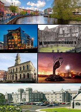
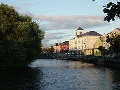
Clockwise from top: View of Garavogue River along JFK Parade, Sligo Abbey, IT Sligo Main Entrance, Clarion Hotel, City Hall, Glasshouse Hotel. | |
 Sligo Location in Ireland | |
| Coordinates: 54°16′00″N 8°29′00″W / 54.2667°N 8.4833°WCoordinates: 54°16′00″N 8°29′00″W / 54.2667°N 8.4833°W | |
| Country | Ireland |
| Province | Connacht |
| County | County Sligo |
| Dáil Éireann | Sligo–Leitrim |
| EU Parliament | Midlands–North-West |
| Area[1] | |
| • Total | 12.9 km2 (5.0 sq mi) |
| Elevation | 13 m (43 ft) |
| Population (2014)[2] | 19,452 |
| • Demonym | Sligonian |
| Irish Grid Reference | G685354 |
| Dialing code | +353 71 |
| Website |
www |
Sligo (Irish: Sligeach, meaning "abounding in shells" — /ˈslaɪɡoʊ/ SLY-goh; Irish pronunciation: [ˈɕlʲɪɟəx]) is a coastal seaport and the county town of County Sligo, Ireland, within the western province of Connacht. With a population of approximately 20,000 in 2014, it is the second largest urban centre in the West of Ireland, with only Galway being larger. The Sligo Borough District constitutes 61% (38,581) of the county's population of 63,000.[3]
Sligo is a historic, cultural, commercial, industrial, retail and service centre of regional importance in the West of Ireland. Served by rail, port and road links, Sligo exerts a significant influence on its hinterland. Sligo is also a popular tourist destination, being situated in an area of outstanding natural beauty, with many literary and cultural associations.
History
Etymology
Sligo is the anglicisation of the Irish name Sligeach, meaning "abounding in shells" or "shelly place". It refers to the abundance of shellfish found in the river and its estuary, and from the extensive shell middens in the vicinity.[4][5] The river now known as the Garavogue (Irish: An Gharbhóg) meaning "little rough one" was originally called the Sligeach.[6] It is listed as one of the seven "royal rivers" of Ireland in the 9th century AD tale The Destruction of Da Dergas Hostel. The river Slicech is also referenced in the Annals of Ulster in 1188.[6]
The Ordnance Survey letters of 1836 state that "cart loads of shells were found underground in many places within the town where houses now stand". The whole area, from the river estuary at Sligo, around the coast to the river at Ballysadare Bay, is rich in marine resources which were utilised as far back as the Mesolithic period.
Early history
The importance of Sligo's location in prehistory is demonstrated by the abundance of ancient sites close by and even within the town. For example, Sligo town's first roundabout was constructed around a megalithic passage tomb at Abbeyquarter North in Garavogue Villas.[7] This is an outlier of the large group of monuments at Carrowmore on the Cuil Irra peninsula on the western outskirts of the town. The area around Sligo town has one of the highest densities of prehistoric archaeological sites in Ireland. It is the only place in which all classes of Irish megalithic monuments are to be found together. Knocknarea mountain, capped by the great cairn of Miosgan Maeve, dominates the skyline to the west of the town. Cairns Hill on the southern edge of the town also has two very large stone cairns.
Excavations for the NRA for the N4 Sligo Inner Relief Road in 2002 revealed a Bronze Age Henge at Tonafortes (beside the Carraroe roundabout) on the southern outskirts of the town, and an early Neolithic causewayed enclosure (c. 4000 B.C.) at Magheraboy on high ground overlooking the town from the south. This is the oldest causewayed enclosure so far discovered in Britain or Ireland.[8] It consists of a large area enclosed by a segmented ditch and palisade, and was perhaps an area of commerce and ritual. These monuments are associated with the coming of agriculture and hence the first farmers in Ireland. According to archaeologist Edward Danagher, who excavated the site, "Magheraboy indicates a stable and successful population during the final centuries of the fifth millennium and the first centuries of the fourth millennium BC".[9]
Sligo bay is an ancient natural harbour, being known to Greek, Phoenician and Roman traders as the area is thought to be the location marked as the city of Nagnata on Claudius Ptolemy's 2nd century AD co-ordinate map of the world.[10] During the early medieval period the site of Sligo was eclipsed by the importance of the great Columban monastery 5 miles to the north at Drumcliff. By the 12th century there was a bridge and small settlement in existence at the site of the present town.
Medieval history
The Norman knight Maurice Fitzgerald, the Lord Chief Justice of Ireland, is generally credited with the establishment of the medieval European-style town and port of Sligo, building Sligo Castle in 1245. The annalists refer to this Sligo as a sraidbhaile ('street settlement') which seems to have consisted of the castle and an attached defensive bawn. A Dominican Friary (Blackfriars) was also founded by Maurice Fitzgerald and the King of Connacht Felim mac Cathal Crobderg Ua Conchobair in 1253. This was accidentally destroyed by fire in 1414, and was subsequently rebuilt in its present form. Norman hegemony was, however, not destined to last long in Sligo.
The town is unique in Ireland in that it is the only Norman-founded Irish town to have been under almost continuous native Irish control throughout the Medieval period. The Normans were halted in northwest Connacht after the battle of Credran Cille in 1257 at Ros Ceite (Rosses Point) between Godfrey O'Donnell, Lord of Tirconnell, and Maurice Fitzgerald. Both commanders were mortally wounded in single combat. This battle effectively halted Norman expansion in the northwest of Ireland.
Despite numerous Anglo-Norman attempts to retake it, it became the administrative centre of the O' Conor Sligo (O'Conchobar Sligigh) confederation of Iochtar Connacht (Lower Connacht). Also called Clan Aindrias, the O 'Conors were a branch of the O' Conchobar dynasty of Kings of Connacht. It continued to develop within the túath (Irish territory) of Cairbre Drom Cliabh. The other Irish territories subject to here were Tireragh (Tir Fhiacrach), Leyney (Lúighne), Tirerill (Tir Olliol) and Corran. Throughout this time Sligo was under the system of Fénechus (Brehon) law and was ruled by the Irish aristocratic warrior class.
Through competition between these warrior clans for the lucrative port duties of Sligo the town was burned, sacked or besieged approximately 49 times during the medieval period, according to the annals of Ireland, however these raids seem to have had little effect on the development of the town as by the mid 15th century the town and port had grown in importance. It traded with Galway, Bristol, France and Spain. Amongst the earliest preserved specimens of written English in Connacht is a receipt for 20 marks, dated August 1430, paid by Saunder Lynche and Davy Botyller, to Henry Blake and Walter Blake, customers of "ye King and John Rede, controller of ye porte of Galvy and of Slego".
Sligo continued under native Irish control until the late 16th century when, during the Elizabethan conquest, Sligo was selected as the County town for the newly shired County of Sligo. An order was sent by the Elizabethan Government to Sir Nicholas Malby, Knight, willing him to establish "apt and safe" places for the keeping of the Assizes & Sessions, with walls of lime & stone, in each county of Connacht, "judging that the aptest place be in Sligo, for the County of Sligo…"[11] The walls were never built.
Later medieval history and early modern era
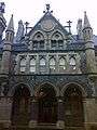
Sligo Abbey, the Dominican Friary, is the only medieval building left standing in the town. Much of the structure, including the choir, carved altar (the only one in situ in Ireland) and cloisters remains.
When Sir Frederick Hamilton's Parliamentarian soldiers partially sacked Sligo in 1642, the Friary was burned and many friars killed.
In 1798 a mixed force of the Limerick Militia, Essex Fencibles and local yeomanry under a Colonel Vereker[12] were defeated at the battle of Carricknagat at Collooney by the combined Irish and French forces under General Humbert. A street in the town is named after the hero of this battle Bartholomew Teeling. The Lady Erin monument at Market Cross was erected in 1899 to mark the centenary of the 1798 Rebellion.[13]
19th century
The town suffered badly from a cholera epidemic in 1832. Scholars speculate that Bram Stoker, whose mother Charlotte Blake Thornley was probably (there are no records and the family lived in both Sligo and Ballyshannon)[14] born in Sligo in 1818[15] and experienced the epidemic first hand, was influenced by her stories when he wrote his famous novel, Dracula. The family lived on Correction Street in the town. After fleeing to Ballyshannon, Charlotte wrote
“At the end of that time, we were able to live in peace till the plague had abated and we could return to Sligo. There, we found the streets grass-grown and five-eighths of the population dead. We had great reason to thank God who had spared us”.[14]
The Great Famine between 1847 and 1851 caused over 30,000 people to emigrate through the port of Sligo.[16] On the Quays, overlooking the Garavogue River, is a cast bronze memorial to the emigrants. This is one of a suite of three sculptures commissioned by the Sligo Famine Commemoration Committee to honour the victims of the Great Famine.
A plaque in the background, headed 'Letter to America, 2 January 1850' tells one family's sad story: "I am now, I may say, alone in the world. All my brothers and sisters are dead and children but yourself... We are all ejected out of Mr. Enright's ground... The times was so bad and all Ireland in such a state of poverty that no person could pay rent. My only hope now rests with you, as I am without one shilling and as I said before I must either beg or go to the poorhouse... I remain your affectionate father, Owen Larkin. Be sure answer this by return of post."
20th century
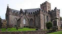
In 1961 St. John the Baptist's Church became a cathedral of the Diocese of Kilmore, Elphin and Ardagh after St. Mary's Cathedral in Elphin was abandoned, being destroyed by a storm four years previously.
War of Independence
Sligo town was heavily garrisoned by the British Army during the War of Independence. For this reason IRA activity was limited to actions such as harassment, sabotage and jailbreaks. At various times during the war prominent Republicans were held at the Sligo Gaol. The commander of IRA forces in Sligo was Liam Pilkington.
Civil War
Arthur Griffith spoke in April 1922 on the corner of O' Connell St. and Grattan St. To this day it is known as Griffiths corner.
Sligo railway station was blown up by Anti-Treaty forces on 10 January 1923.
Geography
Situated on a coastal plain facing the Atlantic Ocean, Sligo is located on low gravel hills on the banks of the Garavogue River between Lough Gill and the estuary leading to Sligo Bay. The town is surrounded by numerous mountains, with the ridges of Slieve Daeane and Killery Mountain to the southeast, Cope’s and Keelogyboy Mountains to the northeast and the distinctive mountains of Knocknarea to the west and Benbulben to the north.
Sligo is an important bridging point on the main north/south route between Ulster and Connacht. It is the county town of County Sligo and is in the Barony of Carbury (formerly the Gaelic tuath of Cairbre Drom Cliabh). Sligo is the diocesan seat of the Roman Catholic Diocese of Elphin. It is in the Church of Ireland Diocese of Kilmore, Elphin and Ardagh.
County Sligo is one of the counties of the province of Connacht. It is part of the Border Region, a region of over 500,000 people which also comprises the counties of Cavan, Donegal, Leitrim, Louth and Monaghan.[17]
Architecture
Medieval core with mainly 19th century buildings many of which are of architectural merit.
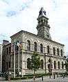
In the nineteenth century Sligo experienced rapid economic growth and therefore architectural change was rapid. This was marked by the erection of many fine public buildings. These include Sligo Town Hall (City Hall), Courthouse, the Gilooly Memorial Hall and the Model School (now the Model Arts & Niland Gallery).
Climate
Sligo's climate is classified, like all of Ireland, as temperate oceanic. It is characterised by high levels of precipitation and a narrow annual temperature range. The mean yearly temperature is 9.4 degrees Celsius (49 degrees Fahrenheit). The mean January temperature is 5.2 °C (41 °F), while the mean July temperature is 15.3 °C (60 °F). On average, the driest months are April to June while the wettest months are October to January.
Rainfall averages 1131 mm (44.5 in) per year. The high rainfall means Sligo is in the temperate rainforest biome, examples of which exist around Lough Gill.[18] The lowest temperature ever recorded in Ireland was −19.1 °C (−2.4 °F) at Markree Castle, County Sligo, on 16 January 1881.
| Climate data for Markree Castle, Co. Sligo (1981–2010 averages) | |||||||||||||
|---|---|---|---|---|---|---|---|---|---|---|---|---|---|
| Month | Jan | Feb | Mar | Apr | May | Jun | Jul | Aug | Sep | Oct | Nov | Dec | Year |
| Daily mean °C (°F) | 5.2 (41.4) |
5.5 (41.9) |
7.1 (44.8) |
8.6 (47.5) |
11.1 (52) |
13.6 (56.5) |
15.3 (59.5) |
14.9 (58.8) |
13.1 (55.6) |
10.2 (50.4) |
7.3 (45.1) |
5.6 (42.1) |
9.8 (49.6) |
| Average rainfall mm (inches) | 130.8 (5.15) |
91.6 (3.606) |
108.9 (4.287) |
77.9 (3.067) |
81.4 (3.205) |
82.2 (3.236) |
93.0 (3.661) |
101.5 (3.996) |
104.4 (4.11) |
134.3 (5.287) |
128.4 (5.055) |
125.7 (4.949) |
1,260.1 (49.61) |
| Source: Met Éireann[19] | |||||||||||||
Demographics
In April 2011 Sligo had a population of 19,452.
There were 15,890 Roman Catholics in the area at census time. A further 1,708 were adherents of other stated religions (e.g. Church of Ireland, Islam, Presbyterian, Orthodox), while 1,119 persons indicated that they had no religion. Non-Irish nationals accounted for 15.8 per cent of the population of Sligo compared with a national average figure of 12.0 per cent. Polish (1,035 persons) were the largest group, followed by UK nationals (390 persons).
6,830 persons could speak the Irish language and of these 1,763 spoke the language daily. 2,947 persons spoke a language other than Irish or English at home and of these 535 could not speak English well or at all. Polish was the most common foreign language spoken at home with 1,021 speakers.
Economy
The service sector is the primary employment sector in the town. The Republic of Ireland’s tool making industry is centred on Sligo, which is a manufacturing centre of considerable importance. The pharmaceutical industry is significant with several companies producing goods for this sector, most notably Abbott (Ireland) Ltd. Abbott is the largest corporate employer in Sligo.
Like many towns in the west of Ireland, Sligo suffered for many years from a lack of development, mainly due to its proximity to the border and poor infrastructure and transport links. However, these have greatly improved in the last decade.
Development has occurred along the River Garavogue with the regeneration of J.F.K. Parade (2000), Rockwood Parade (1993–1997), and The Riverside (1997–2006), as well as two new footbridges over the river, one on Rockwood Parade (1996) and one on The Riverside (1999).
Sligo has a variety of independent shops and shopping malls. The main shopping streets are Wine Street, O'Connell Street, Grattan Street, Stephen Street, High Street, Market Street and Castle Street. Just on the periphery of Sligo in Carraroe there is a retail park that has outlets like Homebase, Smyths Toystore and PC World.
Sligo is a designated gateway under the National Spatial Strategy 2002-2020.
The creative sector is important in Sligo with 4.2% of the population engaged in creative industries, the highest proportion in Connacht, excepting Leitrim.
Culture
Music is of great importance in Sligo, with many musicians both from Sligo and from around the world coming to Sligo to play and improve their craft.
Sligo culture was a significant inspiration on both poet and Nobel laureate W. B. Yeats and his brother the artist, illustrator and comics pioneer Jack Butler Yeats. An extensive collection of Jack B Yeats art is held in the Model Niland Gallery on the Mall.
Yeats Summer School takes place every year in the town and attracts scholars from all over the world, notably Japan.
Sligo town recently highlighted its connections with Goon Show star and writer Spike Milligan, whose father was from Sligo, by unveiling a plaque at the former Milligan family home at Number 5 Holborn Street.
The boy band Westlife was formed in 1998 in Sligo.
Traditional Irish music
Sligo has a long history and an international reputation for Irish music and sessions are held regularly in several venues. Sligo county has its own unique style and is famous all over the world for the quality of its traditional musicians. Many people come from all over the world to learn Irish traditional music in Sligo.
In the early 13th century the poet and crusader Muireadhach Albanach Ó Dálaigh kept a school of poetry at Lissadell north of Sligo town. He was Ollamh Fileadh (High Poet) to the Ó Domhnaill kings of Tír Chonaill. The school appears to have been dissolved after the Norman invasion. In the 16th century, the poet Tadhg Dall Ó hÚigínn wrote many praise poems in strict Dán Díreach metre for local chiefs and patrons such as the O'Conor Sligo. He was killed for a satire he wrote on the O'Haras. The annals record the death in 1561 of Naisse Mac Cithruadh, the "most eminent musician that was in Éireann", by drowning on Lough Gill.
In the 17th century, two brothers from County Sligo, Thomas and William Connellan from Cloonamahon, were among the last of the great Irish bards and harpists. Thomas is the author of the tune Molly MacAlpin, now known as Carolan's Dream, and William may have written Love is a Tormenting Pain and Killiecrankie.
Sligo traditional musicians were important in the revival and transmission of this tradition when they emigrated to New York. Michael Coleman, James Morrison and Paddy Killoran were all recorded at this time. Musicians such as Joe O'Dowd and Eugene " Gene " Preston kept the Sligo tradition alive in the area through the middle of the 20th century. Gene Preston emigrated to Boston, MA ( Dorchester ) and played in all the dance halls 50's - 70's. Here is a link to an album recording circa 1967 https://www.discogs.com/Mike-McDonagh-Connacht-Ceili-Band/release/7571220
Festivals
Sligo hosts many festivals throughout the year including Sligo Live occurring every October, The Sligo Summer Festival which celebrated the 400th anniversary of Sligo town and The Fleadh Cheoil which the town hosted in three consecutive years (1989, 1990 & 1991) and was host again in 2014 & 2015.
Sligo Jazz Project which happens every July is also very popular.
Sligo was host for the Fleadh Cheoil in both 2014 and 2015 where some 400,000 people attended the largest Irish music and dance festival in Ireland. Visitors from all over Europe, North America and Asia were greeted with a real Irish welcome to the sounds of Irish traditional music, much of it played by musicians on the streets of Sligo
Entertainment
Sligo has a vibrant nightlife, and is a popular destination for local residents and a sizeable student population. Sligo has several nightclubs and late bars, particularly along the riverside, an area successfully redeveloped during the 1990s. The town has also become a popular destination for stag and hen parties from all over the country. There are also many pubs and music venues with traditional and contemporary music throughout the year.
Sligo is home to Sligo Baroque Orchestra a string and wind ensemble specialising in Baroque and early classical era Music.
Theatre
Sligo has a strong tradition of theatre, both professional and amateur. Sligo has had a theatre at least as far back as 1750, according to Wood-Martins’ History of Sligo, and often “her Majesty’s servants from the Theatre Royal, Crow Street …. visited Sligo, even during the Dublin season, showing that in those days the townsfolk appreciated the Drama, for in some instances the company remained during several months”.
There are now two full-time theatres in the town. The Blue Raincoat Theatre Company, Ireland’s only full-time venue-based professional theatre ensemble founded in 1990 are based in Quay street.
Sligo is also home to Hawk's Well Theatre a 340-seat theatre founded in 1982. The Hawk’s Well has hosted innovative works by companies such as Red Kettle, Gallowglass, Rough Magic, Project Theatre Company, TEAM, Barabbas, Storytellers, The Blue Raincoat Theatre Company, The Passion Machine, Corcadorca, Kabosh, and many other fine companies from Ireland and abroad.
There is a small professional film industry in Sligo. The studio Sligeach films have produced several features and shorts in Sligo.
In media
Sligo is the gritty setting for author Declan Burkes' series of hard boiled detective novels, featuring detective Harry Rigby.[20]
Sebastian Barry's novels The Secret Scripture and The Whereabouts of Eneas McNulty are also set in Sligo town.
Sligo is the setting[21] for John Michael McDonagh's 2014 darkly comedic drama film Calvary, in which a priest continues to serve his parishioners despite their increased hostility towards him and the Catholic Church.
Sport
Football
The town is home to 2012 League of Ireland Premier Division champions Sligo Rovers, who have played home matches at The Showgrounds since they were founded in 1928. Football is the dominant and most popular sport in Sligo town. The club belongs to the people of Sligo town and is the only co-operatively held club in the League of Ireland.
There are also a sizeable number of junior football clubs who play in the Sligo/Leitrim & District league from the town, the list includes Calry Bohemians, Cartron United, City United & St. John's FC who play in the Super League and Glenview Stars, MCR FC, Merville United & Swagman Wanderers who play in the Premier League. Both Sligo Rovers and St. John's FC have recently been invited to play in the new Connacht Senior League which was due to start in the winter of 2013 but has been postponed for a later date. It was originally held from 1981 to 2000, Sligo Rovers played in this league previously.
Gaelic Games
There are three GAA clubs located in and around the town, they are Calry/St. Joseph's of Hazelwood, St. John's of Cuilbeg & St. Mary's of Ballydoogan with Coolera/Strandhill of Ransboro and Drumcliffe/Rosses Point GAA also being close by. St. John's & St. Mary's compete in the Senior Football Championship while Calry/St. Joseph's compete in the Intermediate Football Championship and the Senior Hurling Championship. These clubs also field Junior, Ladies, Minor and Underage teams. Many of the major Gaelic football & Hurling matches such as an inter-county game or a club championship final take place at Markievicz Park.
Rugby
Sligo RFC is situated at Hamilton Park, Strandhill, 8 km west of the town. They participate in the Ulster Bank All-Ireland League Division 2B.
Other sports
Sligo (in particular Strandhill) has a strong surfing tradition with many locals and visitors learning to surf in the area.
There are two nearby golf courses, Co. Sligo (Rosses Point) Golf Club and Strandhill Golf Club. Also just north of the borough boundary at Lisnalurg, there is Pitch and Putt called Bertie's. Rosses Point is notable for hosting the West of Ireland Championship in which future golfing superstar Rory McIlroy won in consecutive years, 2005 & 2006.
Two basketball clubs cater for the town, they are Sligo All-Stars, based at the Mercy College Gymnasium and Sligo Giant Warriors, whose venue is the Sligo Grammar Gymnasium.
Sligo Racecourse at Cleveragh hosts race days at least 8 times per year.
Other popular sports in Sligo and surrounding areas include Athletics, Boxing, Martial Arts, Rowing, Swimming & Tennis.
Parks and recreation
- Cleveragh
- Doorly Park
Government
Sligo was administered by its own local oireachtas and the kings of Cáirbre Drom Cliab until the English conquest in the early 17th century. This territory corresponds closely to the newly created Sligo Borough District.
Sligo town then became an incorporated municipal borough with a Royal Charter issued by the British King James I in 1613/14. See High Sherriff of Sligo. It had the right to elect 12 burgesses to the corporation.
On June 1, 2014 the old Borough Council was dissolved and administration of the town was amalgamated with the County Council. Sligo is now part of an expanded municipal borough district extending from Collooney to the border with County Donegal at Tullaghan and containing a population of around 40,000. It elects 10 councillors of 18 in total to Sligo County Council.
Sligo has had a mayor since incorporation in 1613. With the re-organisation in 2014 the title of mayor was retained and is elected by the ten borough district councillors.
Law enforcement
From its foundation in the 13th century Sligo was administered under local Fénechus (Brehon law) until the establishment of English Common law in the early 17th century after the battle of Kinsale. Courts were held regularly throughout the tuath at various buildings and on hilltops reserved for the purpose. Law enforcement was a function of the nobility and freemen of the area as no police force existed. No records survive from these early courts, but a case is recorded of a Dublin merchant being reimbursed by the local courts after he was fraudulently sold an out of date poem in the 1540s.[22] Sligo then came under English martial law and eventually the common law as administered from Dublin and from which descends the present system.
The modern Sligo Courthouse was built in 1878. It hosts regular District and Circuit Court sittings throughout the year, and occasionally the High Court.
After 1922 the establishment of Garda Síochána.
Sligo-Leitrim divisional headquarters of An Garda Síochána is on Teeling street in the town on the site of the old R.I.C. barracks.
Health services
Sligo provides hospital services to much of the North Western region. The two main hospitals are Sligo Regional Hospital (formerly General) and St. John's Hospital. There is also a private hospital at Garden Hill.
Education
As of 2011 16.9 per cent of adults were educated to at most primary level only; a further 52.0 per cent attained second level while 31.2 per cent were educated to third level.
Sligo benefits from the presence of a third level institution in the form of the Institute of Technology, Sligo, which offers a diverse range of courses in the disciplines of business, engineering, humanities and science.
St. Angela's College, a constituent college of the National University of Ireland, Galway, offers courses in nursing and health studies, home economics and education. In total, there were 5,206 students enrolled in third level institutes in Sligo in 2011.
*Located outside the Borough Boundary
Third level
Secondary
- Ballinode Community College, Ballinode (Non Demominational)
- Mercy College, Chapel Hill (All girls – Roman Catholic)
- Sligo Grammar School, The Mall (Church of Ireland)
- St. Joseph's Special School, Ballytivnan (Roman Catholic)
- Summerhill College, Circular Road (All boys – Roman Catholic)
- Ursuline College, Finisklin (All girls – Roman Catholic)
Primary
- Carbury NS, The Mall (Church of Ireland)
- Gaelscoil Chnoc Na Ré, Ballydoogan (Irish Language – Roman Catholic)
- Our Lady of Mercy NS, Pearse Road (Roman Catholic)
- Scoil Ursula NS, Knappagh Road (Roman Catholic)
- Sligo School Project, St. Anne's Terrace (Non Denominational)
- St. Brendan's NS, Cartron (Roman Catholic)
- St. Edward's NS, Ballytivnan (Roman Catholic)
- St. Enda's NS, Carraroe* (Roman Catholic)
- St. John's NS, Temple Street (Roman Catholic)
- St. Joseph's Special School, Ballytivnan (Roman Catholic)
Other
- VEC Sligo
- National Learning Network
- Ballytivnan Training Centre
Transportation
Road
The main roads to Sligo are the N4 to Dublin, the N17 to Galway, the N15 to Lifford, County Donegal; and the N16 to Blacklion, County Cavan. The section of the N4 road between Sligo and Collooney is a dual carriageway. The first phase of this road was completed in January 1998, bypassing the towns of Collooney and Ballysadare. An extension to this road was completed in September 2005, and is known as the Sligo Inner Relief Road.
O'Connell Street – the main street in the town – was pedestrianised on 15 August 2006. Plans for the proposed redevelopment and paving of this street were publicly unveiled on 23 July 2008 in The Sligo Champion. The newspaper later revealed that people were not in favour of the pedestrianisation of the street. The street was reopened to traffic in December 2009.
Sligo has a certain amount of cycleways in proximity to the town and various road traffic calming measures have been installed helping to improve safety for pedestrians and cyclists.
Rail
Sligo acquired a rail link to Dublin on 3 December 1862, with the opening of Sligo railway station.[23] Connections to Enniskillen and the north followed in 1881 and Limerick and the south in 1895. The line to Enniskillen closed in 1957 and passenger services to Galway-Ennis-Limerick closed in 1963. For many years Córas Iompair Éireann (CIÉ) kept the latter line open for freight traffic, before its full closure. The proposed Western Rail Corridor redevelopment project seeks to reopen it. In 1966 Sligo railway station was renamed Sligo Mac Diarmada Station after Irish rebel Seán Mac Diarmada from County Leitrim.[24] Irish Rail, the Republic of Ireland's state railway operator, runs inter-city rail services on the Dublin-Sligo railway line. There are currently up to eight trains daily each way between Sligo and Dublin Connolly, with a frequency of every two hours.[25]
Air
Sligo and County Sligo are served by Sligo Airport, 8 km (5.0 mi) from Sligo town and near Strandhill, though no scheduled flights currently operate out of the airport. The nearest airport with scheduled flights is Ireland West Airport Knock near to Charlestown, County Mayo, 55 km (34 mi) away.
The Irish Coast Guard Helicopter Search & Rescue has been based at Sligo Airport since 2004, callsign Rescue 118. CHC Ireland currently provide 24 Hour search and rescue using a Sikorsky S-92 helicopter.
The helicopter is operated by a crew of four, maintained and supported year round. The most northerly base in the Republic of Ireland, it deals with the stern challenges posed by the Atlantic Ocean and the clifftop environment along the north-west coast.[26]
Bus
Bus Éireann operates four bus routes in the town: one serves the town centre and another the west of the town. The other two routes run from the town to Strandhill and Rosses Point respectively.[27] Bus Éireann also provides inter-city services to: Enniskillen, via Manorhamilton; to Derry; to Galway, via Knock Airport; and to Dublin, via Dublin Airport and towns along the N4 road.[28]
Feda O'Donnell offers routes to and from Gweedore to the west of Ireland, including Sligo and Galway, via Ballyshannon.
Sligo Port
Sligo is one of just two operating ports on Ireland's northwest coast between Galway and Derry, the other being Killybegs. At present, the harbour can accommodate ships with a maximum draft of 5.2 metres and length of 100 metres, The Port of Sligo extends from the Timber Jetty at Hyde Road Bridge for a distance of 1.3 km. Sligo County Council took over responsibility for Sligo Harbour from Sligo Harbour Commissioners in June 2006.
The port currently handles cargoes of coal, timber, fish meal and scrap metal and around 25 ships per year dock in the harbour. In 2012 a feasibility study was undertaken into the dredging of the shipping channel.
No fishing boats operate from Sligo Port.
History
Sligo port was at its busiest in the 19th century, and has since declined, but it has a long history. Records first show its development as a port of consequence for agricultural goods to Britain and Europe in the 13th century with the arrival of the Normans. As a port under Gaelic lords, much of the fighting about Sligo was for control of the "cocket" of Sligo port. Merchant families set up trade under this system with the O'Creans wine importers being the most well known. They had contacts in France, Spain and Portugal.
Official English records in the fifteenth century mention ‘Fish Quay’ under King Henry VI reign. Customs duties under the Harbour Commissioners can be traced back to George II. At that time and for two hundred years thereafter, Sligo was the most important port in the northwest (Sligo County Council, 2008).
During the 17th and 18th centuries, Sligo Port established itself as an important focus of trade as part of the British Empire, with good quantities of cattle, hides, butter, barley, oats, and oatmeal being exported and with the city’s linen exports well established. Imports included wood, iron, maize and coal. The town prospered due to the trade with wealthy merchants setting up homes along the then fashionable Castle Street and Radcliffe Street (later renamed Grattan Street). This wealth is demonstrated by the Cathedral of John the Baptist, which was completed as early as 1730. It was designed by Richard Cassels, the architect of many important buildings at the time, such as Leinster House in Dublin and Russborough House in County Wicklow.
During the time of the Great Famine, around 1847-1850, it is estimated that more than 30,000 people emigrated through Sligo Port, mainly to Canada and the United States.
The most notable ship companies who operated out of Sligo included Sligo Steam Navigation Company who introduced the first steamer in 1857, Messrs Middleton & Pollexfen, Harper Cambell Ltd and the former Sligo Harbour Commissioners who owned a number of dredgers used for maintenance of the Channel (McTernan, 1992).[29]
The 1913 Sligo Dock strike lasted for 56 days and was an important precursor to the Dublin Lockout that occurred 6 months later. Unlike the Lockout the Sligo Dock strike resulted in victory to the workers.
The harbour pilots were traditionally based at Rosses Point. The port of Sligo declined during the 20th century with the change from sail to steamships.[30]
Media
There are three local newspapers in Sligo: The Sligo Weekender – out every Thursday (formerly Tuesday), The Free Northwest Express – out the first Thursday of each month and The Sligo Champion – out every Tuesday (formerly Wednesday). Sligo Now is a monthly entertainment guide for the town - this is out on the first Friday of each month, whilst Sligo Sport is the towns sports specific monthly newspaper.
The town has two local/regional radio stations: Ocean FM, broadcasting to Counties Leitrim and Sligo and to parts of County Fermanagh and the south of County Donegal, and West youth radio station i102-104FM, which merged with its sister station i105-107FM in 2011 to create iRadio.
Notable people
Twinning
Sligo is twinned with the following places:
-
 Everett, Washington, United States
 -
 Crozon, Brittany, France
 -
 Illapel, Choapa Province, Chile
 -
 Kempten, Bavaria, Germany
 - Tallahassee, Florida, United States[31]
Gallery
- Images of Sligo
-
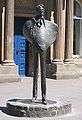
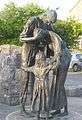
Statue of W. B. Yeats outside the Ulster Bank
-
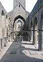
The choir of Sligo Abbey
-
The Sligo Famine Memorial on the Quays
-
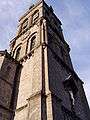
Clock tower of the Roman Catholic Cathedral
-
Sligo Borough Council
-
The Court House
-
Sligo Post Office in 1996
See also
- Development of Sligo
- List of Sligo people
- List of towns and villages in Ireland
- Sligo GAA
- Sligo Gaol
- Sligo Rovers F.C.
- Kilmore, Elphin and Ardagh
- Wild Atlantic Way
- County Sligo
References
- ↑ "Table 6 – Population and area of each Province, County, City, urban area, rural area and Electoral Division, 2002 and 2006" (PDF). Census 2006, Volume 1 – Population Classified by Area. Central Statistics Office. 26 April 2007. pp. 111–112. Retrieved 10 October 2007.
- ↑ "Table 7 – Persons in each town of 1,500 population and over, ..." (PDF). Census 2006, Volume 1 – Population Classified by Area. Central Statistics Office. 26 April 2007. p. 119. Retrieved 13 February 2008.
- ↑ http://www.sligococo.ie/media/SEDP_Chapters1_4.pdf
- ↑ Wood-Martin's History of Sligo, 1882
- ↑ "History of Sligo". Sligo Borough Council – About Us. Retrieved 13 May 2008.
The scallop shells [...] were once abundant in the estuary at the mouth of the Garavogue – a river once known as the 'Sligeach', or 'shelly place', giving Sligo its name
- 1 2 "Origins of Sligo/Slicech/Sligeach". Sligo Heritage. 10 November 2009. Retrieved 1 December 2016.
- ↑ Bergh, Stefan (1995). Landscape of the monuments. A study of the passage tombs in the Cúil Irra region, Co. Sligo, Ireland. Stockholm: Riksantikvarieämbetet Arkeologiska Undersökningar. ISBN 91-7192-945-2.
- ↑ http://www.nra.ie/archaeology/archaeology-ireland-articles/
- ↑ Danaher, Edward (2007). Monumental beginnings: the archaeology of the N4 Sligo Inner Relief Road. Wordwell Books. ISBN 978-1-905569-15-1.
- ↑ http://www.tandfonline.com/doi/full/10.1080/00750770801909375#.Uy3Rmhz1vpU
- ↑ Wood-Martin, W.G. (1892). History of Sligo, County and Town. From the accession of James 1. to the Revolution of 1688. Vol. 2. Dublin: Hodge & Figgis.
- ↑ http://www.sligolibrary.ie/sligolibrarynew/media/MILITARY%20(14).pdf
- ↑ "Lady Erin statue". Sligo town website.
- 1 2 http://www.donegalhistory.com/old/DA57.pdf
- ↑ http://www.bramstokerestate.com/Charlotte-Blake-Thornley_-Stoker-Bram-Abraham-Sligo-Dublin-.html
- ↑ Norton, Desmond (2003). "Lord Palmerston and the Irish Famine Emigration: A Rejoinder". Cambridge University Press, the Historical Journal (46): 155–165.
- ↑ "County Profiles – Sligo". Western Development Commission. Archived from the original on 18 November 2007. Retrieved 13 May 2008.
- ↑
- ↑ "Climate – Monthly Data – Markree". Met Éireann.
- ↑ http://jsydneyjones.wordpress.com/2010/07/13/celtic-crime-declan-burkes-sligo/
- ↑ https://www.theguardian.com/film/2014/jan/20/sundance-film-festival-calvary-review
- ↑ https://books.google.com/books/about/Power_Politics_and_Land.html?id=eqdnAAAAMAAJ&redir_esc=y
- ↑ "Sligo station" (PDF). Railscot – Irish Railways. Retrieved 7 September 2007.
- ↑ Gilligan, James (19 December 2006). "Restore name to Sligo rail station". Sligo Weekender. Sligo Weekender Ltd. Retrieved 3 July 2007.
- ↑ "Timetables and Service Updates – Iarnród Éireann – Irish Rail". Retrieved 18 November 2012.
- ↑ Irish Coast Guard - Search & Rescue.
- ↑ "Sligo City Services – Bus Éireann". Bus Éireann timetable. Retrieved 28 January 2012.
- ↑ "Intercity Services – Bus Éireann". Retrieved 18 November 2012.
- ↑ http://www.environ.ie/en/Foreshore/ApplicationsandDeterminations/SligoCountyCouncil/ApplicationsDetails/FileDownLoad,32814,en.pdf
- ↑ "Search Results - sligo quays". catalogue.nli.ie. Retrieved 2016-02-29.
- ↑ "Tallahassee Irish Society". Retrieved 18 November 2012.
External links
| Wikimedia Commons has media related to Sligo. |
| Wikisource has the text of a 1911 Encyclopædia Britannica article about Sligo. |
- Official site – Sligo Borough Council
- Sligo Heritage
- Sligo and the surrounding area
- Sligo Town on the Net
-
 Sligo travel guide from Wikivoyage
 -
 "Sligo. The capital of County Sligo, Ireland". New International Encyclopedia. 1905.
| History |  | |
|---|---|---|
| Transport | ||
| Culture | ||
| Education | ||
| Sport | ||
Places in County Sligo | ||
|---|---|---|
| Towns |  | |
| Villages and Townlands |
| |
| Islands | ||
| ||