County Down
| County Down Contae an Dúin Coontie Doon/Countie Doun | ||
|---|---|---|
| ||
|
Motto: Absque Labore Nihil (Latin) "Nothing Without Labour" | ||
 | ||
| Country | United Kingdom | |
| Region | Northern Ireland | |
| Province | Ulster | |
| County town | Downpatrick | |
| Area | ||
| • Total | 952 sq mi (2,466 km2) | |
| Area rank | 12th | |
| Population (2011) | 531,665 | |
| • Rank | 4th | |
| Contae an Dúin is the Irish name, Countie Doun[1] and Coontie Doon[2] are Ulster Scots spellings. | ||
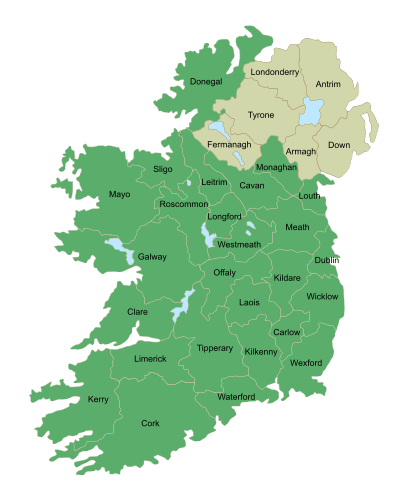
County Down (named after its county town, Downpatrick)[3][4] is one of six counties that form Northern Ireland, situated in the northeast of the island of Ireland. Adjoined to the southeast shore of Lough Neagh, the county covers an area of 2,448 km² (945 sq mi) and has a population of about 531,665. It is also one of the thirty-two traditional counties of Ireland and is within the province of Ulster.
The county was archaically called Downshire. It borders County Antrim to the north, the Irish Sea to the east and south, County Armagh to the west, and County Louth across Carlingford Lough to the southwest. In the east of the county is Strangford Lough and the Ards Peninsula. The largest town is Bangor, on the northeast coast. Three other large towns and cities are on its border: Newry lies on the western border with County Armagh, while Lisburn and Belfast lie on the northern border with County Antrim. Down contains both the southernmost point of Northern Ireland (Cranfield Point) and the easternmost point of Ireland (Burr Point).
It is currently one of only two counties of Ireland to have a majority of the population from a Protestant background, according to the 2001 census. The other is County Antrim to the north. However the main religion in south Down is Catholicism.
History
During the Williamite War in Ireland (1689–1691) the county was a centre of Protestant rebellion against the rule of the Catholic James II. After forming a scratch force the Protestants were defeated by the Irish Army at the Break of Dromore and forced to retreat, leading to the whole of Down falling under Jacobite control. Later the same year Marshal Schomberg's large Williamite expedition arrived in Belfast Lough and captured Bangor. After laying siege to Carrickfergus Schomberg marched south to Dundalk Camp, clearing County Down and much of the rest of East Ulster of Jacobite troops.
Geography

Down contains two significant peninsulas: Ards Peninsula and Lecale peninsula.
The county has a coastline along Belfast Lough to the north and Carlingford Lough to the south (both of which have access to the sea). Strangford Lough lies between the Ards Peninsula and the mainland. Down also contains part of the shore of Lough Neagh. Smaller loughs include Lough Island Reavy.
The River Lagan forms most of the border with County Antrim. The River Bann also flows through the southwestern areas of the county. Other rivers include the Clanrye and Quoile.
There are several islands off the Down coast: Mew Island, Light House Island and the Copeland Islands, all of which lie to the north of the Ards Peninsula. Gunn Island lies off the Lecale coast. In addition there are a large number of small islands in Strangford Lough.
County Down is where, in the words of the famous song by Percy French, "The mountains of Mourne sweep down to the sea", and the granite Mourne Mountains continue to be renowned for their beauty. Slieve Donard, at 849 m (2,785 ft), is the highest peak in the Mournes, in Northern Ireland and in the province of Ulster. Another important peak is Slieve Croob, at 534 m (1,752 ft), the source of the River Lagan.
Places of interest

- An area of County Down is known as the Brontë Homeland (situated between Rathfriland and Banbridge, where Patrick Brontë had his church), after Patrick Brontë (originally Brunty), father of Anne, Charlotte, Emily and Branwell. Patrick Brontë was born in this region.
- The city of Newry in the south of the county contains St Patrick's (Church of Ireland, 1578), overlooking the city centre from Church street, on the east side of the city, which is considered to be Ireland's first ever Protestant church. The Newry Canal is also the first summit-level canal ever to be built in the British Isles.
- Castlewellan Forest Park.
- Down is also home to Exploris, the Northern Ireland Aquarium, located in Portaferry, on the shores of Strangford Lough, on the Ards Peninsula.
- The Old Inn in Crawfordsburn is one of Ireland's oldest hostelries, with records dating back to 1614. It is predated however by Donaghadee's Grace Neill's which was opened in 1611. The Old inn claims that people who have stayed there include Jonathan Swift, Dick Turpin, Peter the Great, Lord Tennyson, Charles Dickens, Anthony Trollope, former US president George H. W. Bush, and C. S. Lewis, who honeymooned there.[5]
- Tollymore Forest Park.
- Scrabo Tower, in Newtownards, was built as a memorial to Charles Stewart, 3rd Marquess of Londonderry.
- Saint Patrick is reputed to be buried at Down Cathedral in Downpatrick, reputedly alongside St. Brigid and St. Columba.
- Saul, County Down (from the Irish: Sabhall meaning "Barn") – where Saint Patrick said his first eucharist in Ireland
Subdivisions
Baronies
- Ards Lower (from the Irish: Aird)
- Ards Upper
- Castlereagh Lower
- Castlereagh Upper
- Dufferin (from the Irish: Duifrian)
- Iveagh Lower, Lower Half (from the Irish: Uíbh Eachach)
- Iveagh Lower, Upper Half
- Iveagh Upper, Lower Half
- Iveagh Upper, Upper Half
- Kinelarty (from the Irish: Cineál Fhártaigh)
- Lecale Lower (from the Irish: Leath Cathail)
- Lecale Upper
- Lordship of Newry
- Mourne (from the Irish: Múrna)
Parishes
Townlands
Settlements
| Historical population | ||
|---|---|---|
| Year | Pop. | ±% |
| 1653 | 13,207 | — |
| 1659 | 15,183 | +15.0% |
| 1821 | 325,410 | +2043.3% |
| 1831 | 352,012 | +8.2% |
| 1841 | 361,446 | +2.7% |
| 1851 | 320,817 | −11.2% |
| 1861 | 299,302 | −6.7% |
| 1871 | 277,294 | −7.4% |
| 1881 | 248,190 | −10.5% |
| 1891 | 224,008 | −9.7% |
| 1901 | 205,889 | −8.1% |
| 1911 | 204,303 | −0.8% |
| 1926 | 209,228 | +2.4% |
| 1937 | 210,687 | +0.7% |
| 1951 | 241,181 | +14.5% |
| 1961 | 266,939 | +10.7% |
| 1966 | 286,631 | +7.4% |
| 1971 | 311,876 | +8.8% |
| 1981 | 417,978 | +34.0% |
| 1991 | 454,411 | +8.7% |
| 2001 | 489,004 | +7.6% |
| 2011 | 531,665 | +8.7% |
| [6][7][8][9][10][11] | ||
Cities
(population of 75,000 or more at 2001 Census)[12]
- Belfast - the eastern suburbs of the city lie partly in County Down but mainly County Antrim
- Lisburn - the eastern suburbs of the city lie partly in County Down but mainly County Antrim
- Newry - the eastern suburbs of the city lie partly in County Down but mainly County Armagh
Large towns
(population of 18,000 or more and under 75,000 at 2001 Census)[12]
Medium towns
(Population of 10,000 or more and under 18,000 at 2001 Census)[12]
Small towns
(Population of 4,500 or more and under 10,000 at 2001 Census)[12]
- Ballygowan
- Ballynahinch
- Comber
- Donaghadee
- Dromore
- Kilkeel
- Newcastle
- Saintfield
- Warrenpoint
Small villages or hamlets(Population of less than 1,000 at 2001 Census)[12]
|
Transportation
Railways

Historic railways
21st century railways
Sport
Association Football
In association football, the NIFL Premiership, which operates as the top division, has one team in the county: Ards F.C., with Warrenpoint Town F.C., Banbridge Town F.C., Bangor F.C. and Lisburn Distillery F.C. competing in the NIFL Championship, which operates as levels two and three.
Gaelic games
The Down County Board administers Gaelic games in the county. Down is the most successful team north of the border in terms of All-Ireland Senior Football Championships won with five in total. In terms of Ulster they share that accolade with Cavan who also have 5 titles. They currently have four minor all Ireland titles (1977, 1987, 1999 and 2005), twelve Ulster titles (1959, 1960, 1961, 1963, 1965, 1966, 1968, 1971, 1978, 1981, 1991, 1994) and one under 21 all Ireland title (1979).
Golf
County Down is also home to the No.1-ranked golf course outside of the US, according to Today's Golfer, Royal County Down, which is situated in Newcastle.
Currently ranked No.1 golfer in the world, Rory McIlroy originates from Holywood, situated in the north of the county.
In popular culture
"Star of the County Down" is a popular Irish ballad.
The county is named in the lyrics of the song "Around the World", from the film Around the World in 80 Days, which was an American top ten hit for Bing Crosby and UK top ten hit for Ronnie Hilton, both in 1957, although it was Mantovani's instrumental version which was actually used in the film. Rihanna's video "We Found Love" was filmed there in 2011.
The Northern Irish singer Van Morrison has made reference to the County Down in the lyrics to several songs including "Northern Muse (Solid Ground)", "Mystic of the East" and the nostalgic "Coney Island", which names several places and landmarks in the County.
People associated with County Down
- Rory McIlroy Former world number one golfer, from Holywood
- Jamie Bryson loyalist activist in Northern Ireland, leading figure in the Belfast City Hall flag protests. Donaghadee
- Josh Magennis Professional footballer currently for Charlton Athlectic F.C. from Bangor
- Christine Bleakley TV Presenter and wife of Footballer Frank Lampard, was born in Newtownards
- Zoe Salmon TV presenter and miss UK contestant is from Bangor
- Keith Gillespie former Manchester United & Newcastle professional footballer grew up in Bangor.
- Bear Grylls Chief scout and TV personality Bear was born in Donaghadee
- Pat Jennings former NI goalkeeper pat hails from Co Down city of Newry
- Gary Lightbody lead singer of popular band Snow Patrol is from Bangor
- Lembit Öpik, former Liberal Democrat MP and Shadow Welsh and Shadow Northern Ireland Secretary. Bangor
- Foy Vance Singer songwriter Bangor
- Motherwell and Northern Ireland defender Stephen Craigan, Newtownards
- Jamie Dornan Actor in 50 shades of grey is from Holywood
- Kristian Nairn, portrayed Hodor in Game Of Thrones Lisburn.
- Colin Murray Sports TV Presenter is from Dundonald
- Paddy Wallace, Rugby union footballer for Ulster and Ireland, Dundonald.
- Ulster Rugby Winger Craig Gilroy was raised in Bangor
- David Healy Northern Ireland record goal scorer is from Killyleagh
See also
- Abbeys and priories in Northern Ireland (County Down)
- List of places in County Down
- Lord Lieutenant of Down
- High Sheriff of Down
References
- ↑ 2008 Annual Report in Ulster Scots North–South Ministerial Council.
- ↑ 2006 Annual Report in Ulster Scots Archived 27 February 2013 at the Wayback Machine. North–South Ministerial Council.
- ↑ Taylor, Isaac. Names and Their Histories. Rivingtons, 1898. p.111
- ↑ Lewis, Samuel. A Topographical Dictionary of Ireland (1837); "The See of Down".
- ↑ Crawfordsburn Old Inn website
- ↑ For 1653 and 1659 figures from Civil Survey Census of those years, Paper of Mr Hardinge to Royal Irish Academy 14 March 1865.
- ↑ Census for post 1821 figures.
- ↑ Histpop.org
- ↑ NISRA.gov.uk Archived 17 February 2012 at the Wayback Machine.
- ↑ Lee, JJ (1981). "On the accuracy of the Pre-famine Irish censuses". In Goldstrom, J. M.; Clarkson, L. A. Irish Population, Economy, and Society: Essays in Honour of the Late K. H. Connell. Oxford, England: Clarendon Press.
- ↑ Mokyr, Joel; O Grada, Cormac (November 1984). "New Developments in Irish Population History, 1700–1850". The Economic History Review. 37 (4): 473–488. doi:10.1111/j.1468-0289.1984.tb00344.x.
- 1 2 3 4 5 6 7 "Statistical classification of settlements". NI Neighbourhood Information Service. Retrieved 23 February 2009.
Further reading
- Harris, Walter (attributed). 1744. The Ancient and Present Stare of the County of Down...'Dublin.
- The Memoirs of John M. Regan, a Catholic Officer in the RIC and RUC, 1909–48, Joost Augusteijn, editor, District Inspector, Co. Down 1930s, 1919, ISBN 978-1-84682-069-4.
External links
| Wikimedia Commons has media related to County Down. |
| Wikivoyage has a travel guide for County Down. |
- County Down at DMOZ
- County Down tourism
- Armagh and Down tourism
- Culture Northern Ireland – Industrial Heritage of County Down
- Down Gaelic Athletic Association/Cumann Lúthchleas Gael Coiste Chontae An Dún
- Genealogy indexes for County Down
- Ardglass fishing port on East Down coast
 |
County Antrim |
| ||
| County Armagh |
|
Irish Sea | ||
| ||||
| | ||||
| County Louth | Irish Sea |
The counties are listed per province | ||
 | ||
| ||