Dromore, County Down
| Dromore | |
| Irish: Droim Mór | |
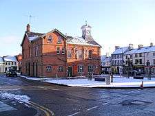
 Dromore town centre from the Mound |
|
 Dromore |
|
| Population | 4,968 (2001 Census) |
|---|---|
| Irish grid reference | J201533 |
| – Belfast | 19 miles (31 km) |
| District | Armagh, Banbridge and Craigavon |
| County | County Down |
| Country | Northern Ireland |
| Sovereign state | United Kingdom |
| Post town | Dromore |
| Postcode district | BT25 |
| Dialling code | 028, +44 28 |
| Police | Northern Ireland |
| Fire | Northern Ireland |
| Ambulance | Northern Ireland |
| EU Parliament | Northern Ireland |
| UK Parliament | Lagan Valley |
|
|
Coordinates: 54°24′54″N 6°08′56″W / 54.415°N 6.149°W
Dromore (from Irish: Droim Mór, meaning "large ridge")[1] is a small market town and civil parish in County Down, Northern Ireland. It lies within the local government area of Armagh City, Banbridge and Craigavon Borough Council. It is 19 miles (31 km) southwest of Belfast, on the A1 Belfast–Dublin road. The 2001 Census recorded a population of 4,968 people. An estimate for current population puts it at around 8000 as of October 2015.
The town's centre is Market Square, which has a rare set of stocks. It is in the old linen manufacturing district. Dromore has the remains of a castle and earthworks, although these have modern buildings surrounding them, a large motte and bailey or encampment (known locally as "the Mound"), and an earlier earthwork known as the Priest's Mount on the Maypole Hill.
History
The name Dromore is an anglicisation of the Irish Druim Mór (modern Irish Droim Mór) meaning "large ridge", with historic anglicisations including Drumore, Drummore and Drummor.[2]
The town features a well-preserved Norman motte and bailey that was constructed by John de Courcy in the early 13th century, shortly after the Norman invasion of Ireland.[3] Known locally as "the Mound", the fort occupies a prominent site to the east of the town centre and has views along the valley of the River Lagan. Dromore remained under Anglo-Norman control until it was captured and destroyed by Edward Bruce during the Irish-Bruce wars of 1315.

It was the seat of the diocese of Dromore, which grew out of an abbey of Canons Regular attributed to Saint Colman in the 6th century. This was united in 1842 to the Diocese of Down and Connor.[4] The diocese was then divided in 1945, with the Diocese of Connor being independent, and the Diocese of Down and Dromore remaining united.
The town and cathedral were wholly destroyed during the Irish Rebellion of 1641, and the present church was built by Bishop Jeremy Taylor in 1661, who is buried there. Also buried in the cathedral is Thomas Percy, another famous bishop of the diocese, who laid out the fine grounds of the palace.[4] A monument to Thomas Percy stands in the Town Park.
Jacobites under command of Richard Hamilton, and rival Williamites fought a battle here on 14 March 1689. The battle took place about a mile out of the town on the Milebush Road and was known as the Break of Dromore. The Jacobites routed the Williamites and they fled in disorder, leaving 400 dead. After this Break of Dromore the Jacobites did not meet any resistance while advancing northwards and occupying Belfast.
Dromore had its own railway station from 1863 to 1956. The Banbridge, Lisburn and Belfast Junction Railway (BLB) through Dromore opened in 1863.[5] Its line was a branch that joined the Ulster Railway main line Knockmore Junction, giving Dromore a direct link to Lisburn and Belfast Great Victoria Street.[5] In 1876 the Ulster Railway became part of the new Great Northern Railway, which took over the BLB company in 1877.[6] In 1953 the railway was nationalised as the GNR Board,[7] which closed the line through Dromore on 29 April 1956.[8]
The Troubles
For more information see The Troubles in Dromore, which includes a list of incidents in Dromore during "the Troubles" resulting in two or more fatalities.
Today
The Dromore Town Centre Development Plan, published in July 2003, outlined that of the 190 units within Dromore Town Centre, over one quarter were vacant. This is in spite of recent population growth in the town; a result of the proximity to the A1 road and resultant commuting access to Greater Belfast.
The green-field development in recent years has mostly been around the edges of the town, and the doughnut effect has led to these houses being disconnected from the town centre. The population of Dromore tends to travel to nearby Banbridge or Sprucefield to shop, which has caused the high levels of obvious dereliction.
The plan highlights the under use of the River Lagan as a resource in the town, as well as the poorly used public space around the Town Hall in the Market Square. The square's 18th Century layout is protected, however it is identified as a traffic problem, which is exacerbated by poor parking provision and enforcement of parking restrictions. In 2008, the area surrounding the Town Hall was cleared to facilitate the construction of leisure space. The project was completed in six months and now has benches and pathways in place of a small car park. The general aesthetics of the site have also been improved.
Demography
Dromore is classified as a small town by the NI Statistics and Research Agency (NISRA) (i.e. with population between 4,500 and 10,000 people). On Census day (29 April 2001) there were 4,968 people living in Dromore. Of these:
- 23.9% were aged under 16 years and 17.5% were aged 60 and over
- 48.2% of the population were male and 51.8% were female
- 13.0% were from a Catholic background and 83.4% were from a Protestant background
- 2.5% of people aged 16–74 were unemployed.
For more details see: NI Neighbourhood Information Service
Transport and communications

Dromore is well served by the Translink Goldline Express bus service 238, running between Belfast and Newry. Translink Ulsterbus service 38 links the town with Belfast, Banbridge and Lisburn (bypassed by express services). However the 38 can stop at all urban and rural bus stops, adding roughly an extra thirty minutes to the Belfast bound journey.
It is a short drive from Dromore to Belfast (about 20–25 minutes off-peak), Lisburn and Banbridge due to the high-quality A1 road/M1 motorway. Belfast International Airport is about 40 minutes away using the A26 (Moira-Antrim road) while Dublin Airport is around seventy to eighty minutes away using the A1/M1. The town, which has been on the main Belfast to Dublin route for centuries, was bypassed in 1972.[9]
The area is also linked with Craigavon (in particular, Lurgan) and Ballynahinch, with the B2 Lurgan Road and B2 Ballynahinch Road respectively. Surrounding villages, such as Kinallen, Dromara and Donaghcloney, are served by unclassified rural routes.
In 2009 a grade-separated junction featuring an underpass was constructed at the junction of the B2 Banbridge Road, A1 dual-carriageway and the Rowantree Road. It was one of four junctions that were grade separated along the route as part of £30 million of safety improvements.[10] It followed the successful construction of a similar style junction at the B2 Hillsborough Road/A1 junction on the northern end of the town.
The dialling code for Dromore, like the rest of Northern Ireland, is 028. Local landline numbers typically appear in the format 028 9269 xxxx. The town's local telephone exchange falls under the Lisburn telephone exchange code, which prior to the Big Number Change in 2000, used area code 01846.
Railways
.jpeg)
Dromore railway station was part of the GNR which was closed by the Ulster Transport Authority.
The station was opened on 13 July 1863.[11]
The station closed on 30 April 1956.
Townlands
Dromore sprang up within the townland of the same name. The following is a list of townlands that are now within the town's urban area, alongside their likely etymologies:[12]
- Balleny, historically Ballyeany (from Irish: Baile Uí Éinigh, meaning "O'Heaney's townland")
- Ballymacormick (from Irish: Baile Mhic Cormaic, meaning "MacCormick's townland")
- Ballymaganlis, historically Ballymagarly (from Irish: Baile Mhig Amhalaidh, meaning "MacAwley's townland")
- Ballyvicknacally (from Irish: Baile Mhic na Caillí, meaning "townland of the hag's son")
- Drumbroneth, historically Drumbrony, Drumfrony (from Irish: Druim Bróncha/Bhrónaí, meaning "Brónach's ridge")
- Lurganbane (from Irish: Lorgain Bhán, meaning "long white ridge")
People
Past and present notable residents include:
- Harry Ferguson (1884–1960): inventor who made the tractor practical
- Sir Jeffrey Donaldson: Northern Ireland politician, DUP MP for Lagan Valley
- David Humphreys: Irish rugby international
- Sir Clarence Graham, Bt.: former Ulster Unionist Party politician
- Tyrone Howe: Irish rugby international and former local UUP Councillor
- Drew Nelson (1956-2016) Former Grand Secretary of the Orange Order
Education
- Primary Schools
- Secondary Schools
- Dromore High School: opened 1958.
formerly Dromore Secondary Intermediate School
- Dromore High School: opened 1958.
Sport
Despite the town's small population, Dromore has a multitude of sport teams and venues.
The two most prominent sports in the town are association football and rugby union, with hockey, lawn bowls and athletics having some popularity also.
Football
The town has one intermediate football team, Dromore Amateurs F.C., who compete in a regional league and play home matches at Ferris Park.
Dromore also has its very own grassroots football set-up: Dromore Amateurs Youth Football Club, which coaches kids from all over the surrounding district. Having only recently formed in 2005/06, the Club has continued to grow from strength to strength and now cater for an impressive 200+ kids from ages 5 to 17.
The Club currently runs a number of youth football teams. For the 2011/2012 season they have teams from the Under 8s and Under 9s playing in the Mid Ulster Youth League Games Development League, teams at Under 10s, Under 11s and Under 12s playing in the George Best Youth League, teams at Under 13s, Under 14s, Under 15s and Under 17s playing in the Mid Ulster Youth League plus a team at Under 16s playing in the Carnbane Youth Football League. The club is also affiliated to the 'Northern Ireland Boys Football Association' and enters teams into the N.I.B.F.A. Cup each season.
Football is also very popular as a social sport, with many groups playing on a daily basis at both municipal sports facilities at Ferris Park and Dromore Community Centre.
Rugby
Rugby union is represented through Dromore Rugby Football Club, who have had some success in recent years. The club are based on Barban Hill in the town and have three rugby pitches and a clubhouse on that site. The club's 1st XV team presently compete in the Ulster Branch of the IRFU's Qualifying League.[13]
Ladies' hockey
The town is represented on a provincial level in ladies field hockey by Dromore Ladies Hockey Club, whose 1st XI competed in the Ulster Women's Hockey Union Senior One league for the 2010/11 season,[14] having won the Ulster Women's Hockey Union "Club of the Year" title in 2007/8. The club have six senior teams and junior teams at all age levels, playing home matches and training at Ferris Park.[15]
Facilities
The main sports facility in the town is Dromore Community Centre (also known as Holm Park), which offers two grass soccer pitches, two tennis courts and a bowling green. In addition to this, the main building contains a gymnasium and an indoor court. The secondary facility is Ferris Park, named after local Olympian Sam Ferris, which provides a full-sized sand-based floodlit hockey pitch, two floodlit tennis courts, a grass soccer pitch and a changing pavilion. Both are maintained by Armagh City, Banbridge and Craigavon Borough Council.[16]
Churches
- Dromore Elim Pentecostal Church[17]
See also
- Dromore, County Down (civil parish)
- List of towns and villages in Northern Ireland
- Market Houses in Northern Ireland
References
- ↑ Placenames Database of Ireland
- ↑ Northern Ireland Placenames Project: Dromore townland (parish of Dromore, County Down)
- ↑ Borderlands Ireland: Dromore Motte and Bailey
- 1 2
 One or more of the preceding sentences incorporates text from a publication now in the public domain: Chisholm, Hugh, ed. (1911). "Dromore". Encyclopædia Britannica. 8 (11th ed.). Cambridge University Press. p. 589.
 - 1 2 Hajducki, 1974, map 9
- ↑ Hajducki 1974, p. xiii.
- ↑ Baker 1972, pp. 146, 147.
- ↑ Baker 1972, p. 207.
- ↑ "Northern Ireland Roads Site: A1 Sprucefield to Beech Hill". Wesley Johnston. Retrieved 7 June 2011.
- ↑ "Northern Ireland Roads Site: New & Future Road Schemes". Wesley Johnston. Retrieved 9 July 2008.
- ↑ "Dromore station" (PDF). Railscot - Irish Railways. Retrieved 2012-05-06.
- ↑ "Northern Ireland Placenames Project". Retrieved 30 May 2010.
- ↑ Ulster Rugby – Qualifying League 11-Jun-2010 The current under 19 team members are some of the most successful players in Dromore RFC history
- ↑ Dromore Ladies Hockey Club 1st XI
- ↑ Dromore Ladies Hockey Club Honours (retrieved 7-Jun-2011)
- ↑ Banbridge District Council: Playing Fields (Ferris Park/Holm Park)
- ↑ http://dromoreelim.org
- Baker, Michael H.C. (1972). Irish Railways since 1916. London: Ian Allan. ISBN 978-0-7110-0282-1.
- Hajducki, S. Maxwell (1974). A Railway Atlas of Ireland. Newton Abbott: David & Charles. ISBN 978-0-7153-5167-3.
External links
| Wikimedia Commons has media related to Dromore, County Down. |
- Dromore Amateurs Youth Football Club
- Dromore Railway Viaduct
- Dromore Weather Live
- Dromore Cathedral
- Dromore Reformed Presbyterian
- Dromore Leader Newspaper website
- Dromore Baptist Church
- Dromore Mound
- Dromore and District Local Historical Group Journal
- Dromore Elim Pentecostal Church
| Large |  | |
|---|---|---|
| Medium | ||
| Small | ||
Italics denote settlements that are classed as towns but also have city status | ||