Saul, County Down

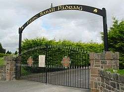
Saul (from Irish Sabhall Phádraig, meaning "Patrick's barn")[1] is the name of a townland (of 488 acres) and civil parish in County Down, Northern Ireland.[2]
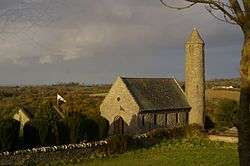
The townland lies to the east of Downpatrick and has strong links with Saint Patrick. It is claimed that when Saint Patrick arrived in Ireland in 432, strong currents swept his boat through the Strangford Lough tidal narrows and he landed where the Slaney River flows into the lough. The local chieftain, Dichu, was quickly converted and gave him a barn for holding services. Allegedly, Saint Patrick died in Saul on 17 March 461 and is buried in nearby Downpatrick. The modern "Saint Patrick's Memorial Church" is built on the reputed spot of this building and includes a replica round tower. To the east of the parish is Saint Patrick's Catholic Church.
Close by, on the crest of Slieve Patrick is a massive statue of Saint Patrick with bronze panels showing scenes from his life.
There is considerable urban sprawl encroaching from nearby Downpatrick. Consequently, the population of the parish is now more diverse. Some long established families still maintain a significant presence in the hamlet, including the Fitzsimons family, the Black family, the Hayes family, the McMullan family and the Quayle family. There is a long established pub and retaurant which has had a number of owners and names. Formerly the Countryside Inn and Saul Tavern it is currently called Paddys Barn.
Civil parish of Saul
The civil parish is in the historic barony of Lecale Lower and contains the following settlements:[2]
- Saul
Townlands
The civil parish contains the following townlands:[2]
- Ballinarry
- Ballintogher
- Ballynagarrick
- Ballysugagh
- Ballywoodan
- Carrowcarlin
- Carrowvanny
- Castle Island
- Gores Island
- Green Island
- Hare Island
- Launches Little Island
- Launches Long Island
- Lisbane
- Lisboy
- Portloughan
- Quoile
- Ringbane
- Russells Quarter North
- Russells Quarter South
- Salt Island
- Saul
- Shark Island
- Walshestown
- Whitehills
See also
References
External links
Coordinates: 54°20′38.13″N 5°40′28.29″W / 54.3439250°N 5.6745250°W