Loughinsholin
| Loughinsholin Loch Inse Ui Fhloinn[1] (Irish) | |
|---|---|
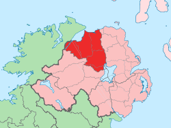
 Location of Loughinsholin, County Londonderry, Northern Ireland. | |
| Sovereign state | United Kingdom |
| Country | Northern Ireland |
| County | Londonderry |
Loughinsholin (from Irish Loch Inse Ui Fhloinn, meaning "lough of O'Lynn's island"[1]) is a barony in County Londonderry, Northern Ireland.[2] Its southeast borders the northwest shore of Lough Neagh, and itself is bordered by seven other baronies: Dungannon Upper to the south; Strabane Upper to the west; Keenaght and Coleraine to the north; Kilconway, Toome Upper, and Toome Lower to the east.[2]
The Sperrin Mountains rise to the west of Loughinsholin, with Slieve Gallion and Carntogher the two most notable mountains of the range in the barony.[1] The Ballinderry River flows along the southern boundary of the barony, with the River Moyola cutting through the middle, both emptying into Lough Neagh. The largest settlement in the barony is town of Magherafelt.
History
The area of land that forms Loughinsholin has changed control several times throughout history. During the first millennium, it was part of the Cruithin over-kingdom of Ulaidh. It would then become part of the over-kingdom of Airgialla, founded by the Three Collas from their conquests in Ulster. One of the under-kingdoms of Airgialla was Ui Tuirtri, named after Fiachu Tuirtri, son of Colla Uais (one of the Three Collas), which stretched from the River Blackwater south of Dungannon to the River Bior (meaning water, modern day Moyola River[3]), located half a mile north of Tobermore.
The Ó Floinn sept (English: O'Lynn) would come to prominence in Ui Tuirtri, with their power-base situated on a crannog just outside the modern village of Desertmartin. The lake this crannog lay in became known as "Lough Insholin" and was preserved as the name of the barony of Loughinsholin upon its creation. Centuries later, Shane More O'Hagan, once owner of Calmore Castle within the parish of Kilcronaghan in the barony, later married a lady from these O'Lynn's and took up residence at "Lough Insholin".[4]
With the expansion of the Cenél nEógain into Airgialla, the territory of Ui Tuirtri west of the river Bann eventually passed into the overlordship of Tir Eóghain.[5] By the 1350s, the Clandeboye O'Neills had stepped into the power-vacuum left by the collapse of the Earldom of Ulster,[6] and expanded to encompass all of Ui Tuirtri.
The last recorded lord of Loughinsholin was Brian Carrach O'Neill from a branch of the Clandeboye O'Neills. Brian Carrach's residence along the border of the parishes of Kilcronaghan and Ballynascreen became known as Dún Tí Bhriain (preserved as the townland of Duntibryan).[7] His daughter Anne, was the second wife of last prince of Clandeboye, Shane MacBryan O'Neill of Edenduffcarrick, later known as Shane's Castle, Antrim. Brian Carrach died in 1586.[4] The Line has supposedly been kept in existence by a lower branch of the family, although this claim has never been proved. The current claimant to the title is Peter O'Neill of Ballynascreen.
On 15 July 1591, County Tyrone was divided into eight baronies, of which one was "Loghynisolin", containing the districts of Cloncankayne (Glenconkeyne) and Kilytraghe (Killetra).[8][9]
Charter of Londonderry
The barony of Loughinsholin upon creation was originally part of County Tyrone, and in the survey of 1609, the map for the area shows it divided into two sections; the first of which contains the ancient Irish districts of "Killetragh" (Killetra), "Tomlagh", "Tarraghter", and "Melannagh" (Melanagh). The second of which contained the ancient districts of "Glanconkeyne" (Glenconkeyne) and "Clandonel" (Clandonnell).[10]
In 1613 however as part of the Charter of Londonderry, most of the barony except for the south-western portion consisting of Tarraghter and Melanagh, was incorporated into the new county of Londonderry. The remainder, which remained in County Tyrone, along with the barony of Mountjoy was amalgamated with that of Dungannon.[11][12]
Proportions
Prior to 1613 and the creation of County Londonderry, the barony of Loughinsholin, like that of Coleraine, Keenaght, and Tirkeeran, was divided up into "proportions" for the survey carried out in 1609. The names and extent of these proportions were recited in the grant of the new county to The Honourable The Irish Society.[10]
In most instances each proportion lay within one of the ancient territories that consisted the barony, in which each proportion consisted of a number of townlands.[10]
Killetra
- Ballinemanagh - A middle proportion consisting of 1,500 acres, besides glebe land.[10]
- Drumrott - A small proportion consisting of 1,000 acres, besides glebe land.[10]
- Tirnafessy - A small proportion consisting of 1,000 acres, besides glebe land.[10]
Clandonnell
- Gortconra - A great proportion consisting of 2,000 acres, besides glebe land.[10]
- Ballymacrossy - A small proportion consisting of 1,000 acres.[10]
Glenconkeyne
- Moysaden - A small proportion consisting of 1,000 acres.[10]
- Cohoire - A small proportion consisting of 1,000 acres, besides glebe land.[10]
- Cynah - A small proportion consisting of 1,000 acres, besides glebe land.[10]
Tomlagh
- Balleletrim - A great proportion consisting of 2,500 acres, besides glebe land.[10]
Other proportions
- Corramony - A small proportion split between Clandonnell and Glenconkeyne consisting of 1,000 acres, besides glebe land.[10]
- Lackah - A small proportion split between Killetra and Tomlagh consisting of 1,000 acres.[10]
- Tyrassan - A small proportion consisting of 420 acres.[10]
- Lands in Killetra that in all make up two proportions consisting of 420 and 560 acres respectively.[10]
List of settlements
Below is a list of settlements in Loughinsholin:[1]
Towns
Villages
- Ballyronan
- Bellaghy
- Castledawson
- Clady
- Desertmartin
- Draperstown
- Inishrush
- Kilrea
- Knockloughrim
- Maghera
- Moneymore
- Swatragh
- Tamlaght
- The Loup
- Tobermore
- Upperlands
Hamlets and population centres
- Ballinderry Bridge
- Ballymaguigan
- Ballyneese
- Churchtown
- Glen
- Herveyhill
- Tamlaght O'Crilly
- The Six Towns
List of civil parishes
Below is a list of civil parishes in Loughinsholin:[13]
- Arboe (split with barony of Dungannon Upper)
- Artrea (split with barony of Dungannon Upper)
- Ballinderry (split with barony of Dungannon Upper)
- Ballynascreen
- Ballyscullion (split with barony of Toome Upper)
- Derryloran (split with barony of Dungannon Upper)
- Desertlyn
- Desertmartin
- Kilcronaghan
- Killelagh
- Kilrea
- Lissan (also partly in barony of Dungannon Upper)
- Maghera
- Magherafelt
- Tamlaght (split with barony of Dungannon Upper)
- Tamlaght O'Crilly (split with barony of Coleraine)
- Termoneeny
References
- 1 2 3 4 Logainm - Barony of Loughinsholin
- 1 2 PRONI Baronies of Northern Ireland
- ↑ Magherafelt Parish
- 1 2 Statistical Reports of Six Derry Parishes 1821, John MacCloskey
- ↑ Ireland's History In Maps
- ↑ Medieval Ireland: An Encyclopedia. Editors Seán Duffy, Ailbhe MacShamhráin, and James Moynes
- ↑ Mr. John O'Donovan's Letters from County Londonderry (1834)
- ↑ Reeves, William. Acts of Archbishop Colton in his Metropolitan Visitation of the Diocese of Derry, A.D. MCCCXCVII. Dublin: printed for the Irish Archaeological Society, 1850.
- ↑ "Inquisitionum in Officio Rotulorum Cancellariae Hiberniae Asservatarum Repertorium". 1829. Retrieved 12 May 2015.
- 1 2 3 4 5 6 7 8 9 10 11 12 13 14 15 16 The Conquest of Ireland - County Londonderry Lands and Families in Northern Ireland, page 388, Rev. George Hill
- ↑ - A New History of Ireland, pages 111-112
- ↑ Map depicting the baronies that were part of the Plantation of Ulster
- ↑ Map of the baronies and civil parishes of County Londonderry