Mulhuddart
| Mulhuddart Mullach Eadrad | |
|---|---|
| Suburb of Dublin | |
|
Main junction at Mulhuddart | |
 Mulhuddart Location in Ireland | |
| Coordinates: 53°24′07″N 6°20′24″W / 53.402°N 6.340°WCoordinates: 53°24′07″N 6°20′24″W / 53.402°N 6.340°W | |
| Country | Ireland |
| Province | Leinster |
| County | Fingal |
| Dáil Éireann | Dublin West |
| EU Parliament | Dublin |
| Population (2011) | |
| • Urban | 3,866 |
| Postal district(s) | Dublin 15 |
| Dialing code | 01, +353 1 |

Mulhuddart (Irish: Mullach Eadrad, meaning "the hill of the milking place") is a suburb situated 12 km (7.456 miles) north-west of Dublin city, Ireland. It is also a civil parish in the barony of Castleknock. The River Tolka passes near the village. Mulhuddart is also a parish in the Blanchardstown deanery of the Roman Catholic Archdiocese of Dublin.
Location and access
The N3 dual carriageway now by-passes the village. It is located near Blanchardstown, now also a suburb of Dublin. It is bordered by County Meath to the west and by the civil parishes of Ward to the north, Finglas to the east and Clonsilla to the south.
Mulhuddart village essentially comprises a main street, which was the old Navan Road, on which there are a petrol station, a few shops and cafés. The local school, Mulhuddart National School, was relocated to a building on the Powerstown Road and will shortly move to a new premises in Tyrellstown and be renamed St. Lukes. Though the village has been by-passed, an under-pass connects the main street to Blakestown. Mulhuddart includes the suburban localities of Ladyswell, and Manorfield, together with townlands such as Priesttown. Newer estates to the west of the village such as Swallowbrook and Pheasant's Run are within the townland of Mulhuddart.
Located on the outskirts of the village is the Damastown Industrial Estate, one of Dublin's largest industrial estates which includes a large IBM campus employing over 4,000 people. To the north is the village of Tyrrelstown, with a sizable modern housing development.
Buses
Public transport in Mulhuddart is provided by Dublin Bus routes 38, 38a, 38b, 39n and 220.[1]
History
Placenames

The origins and meaning of the name Mulhuddart are unknown. However a number of explanations are offered, the most likely being that the name came from the Irish Mullach Eadartha meaning "the hill of the milking place". In ancient Ireland, cows were driven out onto upland pastures during the summer months and special places were designated for their milking.
Many townland names surrounding the village owe their origins to Norman settlers who colonised the area after the Norman capture of Dublin in 1170. "Buzzardstown" is so called after the family of William Bossard and "Tyrrellstown" is named after a branch of the Tyrrells, who were created barons of Castleknock in 1173.
The townland of Goddamendy is perhaps the only townland in Ireland containing a prayer in its name. Tradition has it that when a priest arrived late for the anointing of a dying man, the dead man's relative cursed the priest, who replied "May God amend thee!"
Features

There are a number of antiquities and old houses in the area. These include the ruins of the Church of Mary, Our Lady's Well which was used widely by pilgrims back in the early century, Mulhuddart National School and Parlickstown House. The Ordnance Survey of Ireland Sheet 50 map also shows a graveyard and burial ground at Cloghran.
Muluddart Church, the Church of Mary, stands above the village on a hill which until recently, before housing development began to encroach, afforded fine views of the Wicklow Mountains (the mountains are still visible, though not as prominently). The church stands on a curved mound, suggesting it was built on the site of an earlier church which was protected by an enclosure. The current ruins post-date the Anglo-Norman settlement of the area.
Proclamation memorial monument
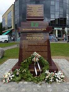
In May 2016, a 1916 centenary monument was unveiled at the main junction of Mulhuddart, to commemorate the executed leaders of the 1916 Easter Rising.
As well as including the names of the executed leaders, the monument is also inscribed with the 1916 proclamation on the front. On the back, it is inscribed with the Democratic Programme adopted by the First Dáil.
The memorial was funded entirely by donations from the local community at the cost of €14,000.[2]
Primary schools
- St Patrick's national school (boys and girls, Roman Catholic), located in the parish of Corduff.
- Scoil An Cheathair Alainn (boys and girls, Roman Catholic), located in Mulhuddart.
Government and representation
Mulhuddart is administered by Fingal County Council. For the purposes of elections to Dáil Éireann, it is part of the Dublin West constituency.
In the 2014 local elections, the following candidates were elected to the eight Mulhaddart ward seats (party affiliation, percentage share of first preference vote): Paul Donnolly, Sinn Féin, 27%; Ruth Coppinger, Anti Austerity Alliance, 22%; David McGuinness, Fianna Fail, 12%; Kieran Dennison, Fine Gael, 7%; Mary McCamley, Labour, 5%; Lorna Nolan, Independent, 3%; Edmond Lukusa, Sinn Féin, 3%; Annette Hughes, Anti Austerity Alliance, 2%.[3]
Mulhuddart is in the Dublin West (Dáil Éireann) constituency. It is also in the Dublin (European Parliament) constituency.
See also
References
- "Mulhuddart, A History of a Suburban Village", published as part of a larger book by the parish of Mulhuddart to commemorate the opening of its new Church in 1993.