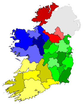
NUTS statistical regions of the Republic of Ireland
The Nomenclature of Territorial Units for Statistics (NUTS) is a geocode standard for referencing the subdivisions of Ireland for statistical purposes. The standard is developed and regulated by the European Union. The NUTS standard is instrumental in delivering the European Union's Structural Funds. The NUTS code for Ireland is IE and a hierarchy of three levels is established by Eurostat. Below this are two further levels of geographic organisation - the Local administrative unit. In Ireland, the LAU-1 subdivisions correspond to an administrative division within the country. The LAU-2 level is not used for local government purposes.
Overall
| Level | Number of Subdivisions |
|---|---|
| NUTS 1 | 1 (the entire state) |
| NUTS 2 statistical regions | 2 |
| NUTS 3 statistical regions | 8 |
NUTS levels 1, 2 and 3
| NUTS 1 | Code | NUTS 2 | Code | NUTS 3 | Code |
|---|---|---|---|---|---|
| Éire / Ireland |
IE0 | Border, Midland and Western NUTS-II Region | IE01 | Border Region | IE011 |
| Midlands Region, Ireland | IE012 | ||||
| West Region, Ireland | IE013 | ||||
| Southern and Eastern NUTS-II Region | IE02 | Dublin Region | IE021 | ||
| Mid-East Region, Ireland | IE022 | ||||
| Mid-West Region, Ireland | IE023 | ||||
| South-East Region, Ireland | IE024 | ||||
| South-West Region, Ireland | IE025 |
Local administrative units 1 and 2
The first level of local administrative unit (LAU-1), which was previously called NUTS-4, is the level immediately below NUTS-3. In Ireland, LAU-1 areas are identical with the areas under the jurisdiction of county and city councils. The second level (LAU-2) corresponds to the areas defined by District electoral divisions.
| LAU level | Subdivisions | # |
|---|---|---|
| LAU 1 | Administrative counties and cities | 31 |
| LAU 2[1] | District electoral division | 3441 |
North Tipperary County Council and South Tipperary County Council were unified into a single local authority for the county on the 1st June, 2014. The current NUTS classification was released in 2013, and remains in place until the end of 2016, therefore Tipperary remains divided for statistical purposes in two different NUTS 3 regions until the next amendment to the classification is released in 2017, which will take into account the changes to the Local Administrative Units of each member state.
See also
Sources
- The LAU codes of Ireland can be downloaded here:

- Hierarchical list of the Nomenclature of territorial units for statistics - NUTS and the Statistical regions of Europe
- Overview map of EU Countries - NUTS level 1
- Correspondence between the NUTS levels and the national administrative units
- List of current NUTS codes
- Counties of Ireland, Statoids.com
References
- ↑ Eurostat - Equivalence of DEDs to LAU-2 units in Ireland
- ↑ Central Statistics Office
- ↑ The code refers to the code in use for the purpose of vehicle registration plates in Ireland. The code may straddle the jurisdictions of several council areas, as in the case of the four entities of the Dublin Region.