Kilbarrack
| Kilbarrack Cill Bharróg | |
|---|---|
| Town | |
 Kilbarrack Location in Ireland | |
| Coordinates: 53°23′N 6°09′W / 53.383°N 6.150°WCoordinates: 53°23′N 6°09′W / 53.383°N 6.150°W | |
| Country | Ireland |
| Province | Leinster |
| County | County Dublin (Dublin City) |
| Elevation | 10 m (30 ft) |
| Time zone | WET (UTC+0) |
| • Summer (DST) | IST (WEST) (UTC-1) |
Kilbarrack (Irish: Cill Bharróg - Church of St. Berach or of young Barra) is a residential suburb of Dublin, Ireland, running inwards from the coast, about 8 km (5.0 mi) from the city's centre. Modern-day Kilbarrack is within the jurisdiction of Dublin City Council, with part of its old lands now in Donaghmede, and part in Bayside under Fingal County Council jurisdiction.
Location and access

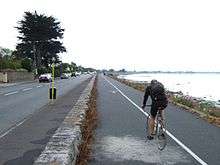
Kilbarrack is situated on the Northside of the city, between the suburbs of Raheny, Donaghmede and Bayside (the latter was formed from Kilbarrack's old core). It originally bordered Sutton, Dublin also, and the coastal part may still do so. Its coastal area faces North Bull Island across the water known as Raheny Lake or Crab Water.
Kilbarrack is accessible from the coast road and the Tonlegee Road, by its own station on the (DART) Dublin Area Rapid Transit suburban rail system (as well as from Raheny and Howth Junction stations), and by Dublin Bus (in 2007, routes 17A, to Finglas, and 31/A/B and 32/A/B, from the city centre to more remote suburbs). It is around 5 km (3.1 mi) from the M1 and M50 motorways and 7 km from Dublin Airport. Kilbarrack railway station opened on 1 June 1969.[1]
History and nature
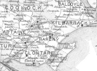
Kilbarrack is an old district, whose name can be found on maps and sea charts, many held at Dublin City Archive, going back several hundred years. It was historically a large area of fields, many being 'grange' lands held by Dublin church establishments, with small settlements. Over time, two hamlets emerged, Kilbarrack proper, near the seafront, close to the still-extant Kilbarrack Church and Graveyard complex (illustrated below), and Little Kilbarrack, on the road inland (now Tonlegee Road).
The district is crossed by one of Dublin's small waterways, the Kilbarrack Stream or Donough Water, which enters the sea in two branches.
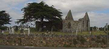
The coastal church ("mapped as Kilbarrack Church, in ruins") and surrounding graveyard were a point of call for mariners, and the church is noted in some records as the Chapel of Mone. At one time, ships entering Dublin Bay paid monies to the city authorities towards the upkeep of the chapel. The cemetery, which still accepts burials in existing graves, includes the grave of the "Sham Squire."
The site of Kilbarrack hamlet, and the part of the district bounding Sutton and Baldoyle, are now together known as Bayside (from inside Kilbarrack Road to Baldoyle Road), while today's Kilbarrack, and the Greendale shopping and civic complex, are close to where Little Kilbarrack stood. The Tesco-led shopping centre is near the site of the former "big house" of the area, Kilbarrack House.
In the 1970s, Swans Nest Court, a complex of tower blocks of flats was built by Dublin Corporation. It was demolished and redeveloped into social and affordable housing in the early 2000s after it fell into disrepair.
Amenities
Kilbarrack has a local office of Dublin City Council, two shopping precincts (Greendale, with a large Centra, and Kilbarrack, dominated by Tesco, which has renovated it twice over the last decade) and a range of shops and pubs. There is a major Health Services Executive centre, and, at the boundary with Raheny and Donaghmede, a Municipal Fire Station and practice yard.
Kilbarrack has five primary schools, three in one grouping: Scoil Eoin, the Educate Together North Bay School and Gaelscoil Mide, previously of Donaghmede, and two in another group: St. Benedict's and St. Mary's, located beside St. Benedict's parish church.
Kilbarrack is also well known for its sporting clubs and teams, which include Bay City Boxing Club, Naomh Barrog GAA Club (http://www.naomhbarrog.ie), Kilbarrack United FC (http://www.kilbarrackunited.com), who play in the top Division of the AUL, and Kilmount Boys FC (Currently Amateur Football League Champions 2007-8)
The modern Parish Church (Roman Catholic) serves Kilbarrack and part of Raheny (Parish of Kilbarrack-Foxfield); some locals attend St. Benedict's Church in Grange Park Parish, which also serves some in Raheny.
People
- Author, Booker Prize winner and former teacher at Greendale Community School in Kilbarrack, Roddy Doyle, is seen by many as having captured the atmosphere and spirit of Kilbarrack, thinly disguised as Barrytown, in a series of popular fiction works.
- Catherine Barry, author of three books ("House That Jack Built", "Null and Void" and "Skin Deep") also currently lives in Kilbarrack.
- Several-times Irish minister Michael Woods lives on Kilbarrack Road near where the district meets Bayside.
- Margaret Harford (née Fox) occupied the cemetery cottage, managed the cemetery and was the District Registrar of Births and Deaths for Howth District for most of the 1930s, 1940s and part of the 1950s.[2]
- Andrew Maxwell, stand-up comedian.
In Popular Culture
The 1996 film The Van, part of Roddy Doyle's Barrytown trilogy, was filmed in Kilbarrack including a real pub called The Foxhound Inn where the title "character" was parked.
See also
References
- ↑ "Kilbarrack station" (PDF). Railscot - Irish Railways. Retrieved 2007-09-03.
- ↑ Personal information from grandson, Martin Connolly, Sydney, Feb 2008
External links
- Radio Documentary about the St. Benedict's Multimedia Group in Kilbarrack Radio Documentary from Near90fm
| Wikimedia Commons has media related to Kilbarrack. |