Washington State Route 524
| ||||
|---|---|---|---|---|
|
SR 524 highlighted in red. | ||||
| Route information | ||||
| Auxiliary route of I‑5 | ||||
| Defined by RCW 47.17.730 | ||||
| Maintained by WSDOT | ||||
| Length: | 14.56 mi[1] (23.43 km) | |||
| Existed: | 1964[2] – present | |||
| Major junctions | ||||
| West end: |
| |||
|
| ||||
| East end: |
| |||
| Highway system | ||||
| ||||

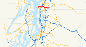
State Route 524 (SR 524) is a 14.56-mile (23.43 km) long state highway in the U.S. state of Washington, located entirely within Snohomish County and serving Edmonds, Lynnwood, Bothell and Maltby. The roadway begins at SR 104 in Edmonds and travels east past SR 99, Interstate 5 (I-5), under I-405, past SR 527 and SR 9 to end at SR 522 in Maltby. The road also has two spur routes, one connecting to SR 104 in Edmonds and another connecting to I-5 in Lynnwood. First appearing on a map in 1895, the highway was designated as part of Secondary State Highway 1W (SSH 1W) in 1957 during an extension from Edmonds to Lynnwood. SSH 1W was extended further to SSH 2J (present-day SR 527) in 1959 before becoming SR 524 in 1964. A final extension east to SR 522 was completed in 1991.
Route description
State Route 524 (SR 524) begins at an intersection with SR 104 in Edmonds near the Edmonds Ferry Terminal, which is owned and operated by Washington State Ferries and serves as the eastern end of the Edmonds-Kingston route across Puget Sound to Kingston.[3] From the interchange, the highway travels east as Main Street and intersects 3rd Avenue, which continues south as SR 524 Spur.[1] The roadway then turns north as 3rd Avenue and later turns east as Caspers Street and north as 9th Avenue before becoming Puget Drive and later 196th Street Southwest and continuing east into Lynnwood.[1] In Lynnwood, the road passes the Edmonds Community College and intersects SR 99 before passing Scriber Lake and 44th Avenue, which is another SR 524 Spur, to interchange with Interstate 5 (I-5). Within the interchange, SR 524 passes over I-5 while Alderwood Mall Boulevard, which connects to nearby Alderwood Mall, passes over the roadway.[4] Leaving the interchange, the road is named Filbert Road and leaves Lynnwood before curving northeast under I-405.[1][5] From I-405, the highway travels southeast into Bothell, where the roadway is once again renamed to 208th Street and intersects SR 527, where it is again renamed to Maltby Road.[1] Leaving Bothell, SR 524 continues east into Maltby and passes SR 9 before crossing railroad tracks once owned by Northern Pacific Railway.[6] After the crossing, the road turns south as Yew Way and east as Paradise Lake Road before ending at SR 522.[1][7][8] The busiest section on the highway in 2007 was west of the I-5 interchange, which was used by an estimated daily average of 47,000 motorists;[9] the bustiest section in 1970 was at the Cedar Way (now 44th Avenue / SR 524 Spur), with a daily average of 25,900 motorists.[10]
History
The first segment of SR 524 to appear on a map was the Edmonds–Scriber Lake section, which was on an 1895 map of the area.[11] In 1937, a road extending from Primary State Highway 1 (PSH 1) the Snohomish–King county line to Edmonds was designated Secondary State Highway 1W (SSH 1W) in 1937, during the creation of the Primary and secondary state highways.[12] SSH 1W was extended east back to PSH 1 in Lynnwood in 1957 and extended further east to SSH 2J in Bothell in 1959.[13][14][15] During the 1964 highway renumbering, PSH 1 became Interstate 5 (I-5), SSH 1W became SR 104 and SR 524 and SSH 2J became SR 527.[6][16] SR 524 was further extended to SR 522 in 1991.[17] In October 2005, the Washington State Department of Transportation (WSDOT) repaved and added safety features to a segment extending from I-5 in Lynnwood to Richmond Road near Bothell.[18][19]
Spur routes
Edmonds spur
| |
|---|---|
| Location: | Edmonds |
State Route 524 Spur is a 0.70-mile (1.13 km) spur route in Edmonds, Washington that connects its parent State Route 524 in the north with State Route 104 in the south. SR 524 Spur begins at SR 524 shortly after its western terminus and travels south as 3rd Avenue and west as Pine Street to SR 104 north of Woodway city limits;[1]
In the 1970s, after SR 524 and SR 104 already had their routing through Edmonds in place, the Washington State Ferries moved the toll booth and holding area for the Edmonds ferry terminal off the pier and along SR 104. This made the ferry terminal inaccessible from westbound SR 524. Thus, a spur route was signed south along Third Avenue and Pine Street to connect with SR 104 and the ferry terminal.[10][20]
Lynnwood spur
| |
|---|---|
| Location: | Lynnwood |
The Lynnwood spur begins at SR 524 and goes south 0.50 miles (0.80 km) to an interchange with Interstate 5 (I-5);[1][8][21] the highway was established between 1964 and 1970.[10][16]
When SR 524 was originally extended to I-5, its interchange was only on the west side of the freeway. To accommodate traffic going in all directions, an interchange on 44th Ave W was built. 44th then became recognized as a spur of 524 (even though it's not posted anywhere along the road). Although the spur is no longer needed to make a complete SR 524's interchange with I-5, it is still part of Washington's highway system.
Major intersections
The entire route is in Snohomish County.
| Location | mi[1] | km | Destinations | Notes | |
|---|---|---|---|---|---|
| Edmonds | 0.00 | 0.00 | |||
| 0.12 | 0.19 | ||||
| Lynnwood | 3.57 | 5.75 | |||
| 4.76 | 7.66 | ||||
| 5.25 | 8.45 | ||||
| | 6.75 | 10.86 | No access | ||
| Bothell | 9.50 | 15.29 | |||
| Maltby | 12.84 | 20.66 | |||
| 14.56 | 23.43 | ||||
1.000 mi = 1.609 km; 1.000 km = 0.621 mi
| |||||
References
- 1 2 3 4 5 6 7 8 9 Washington State Department of Transportation (2006). "State Highway Log: Planning Report, SR 2 to SR 971" (PDF). Retrieved June 29, 2009.
- ↑ Washington State Legislature. "RCW 47.17.730: State Route 524". Retrieved June 29, 2009.
- ↑ Edmonds / Kingston Route Map (Map). Washington State Ferries. Retrieved June 29, 2009.
- ↑ Washington State Department of Transportation (May 6, 2009). "SR 5 – Exit 181B; Junction SR 524 / 196th St SW" (PDF). Retrieved June 29, 2009.
- ↑ City of Lynnwood and Snohomish County Area with Lynnwood Address (PDF) (Map). City of Lynnwood. 2009. Retrieved June 29, 2009.
- 1 2 United States Geological Survey (1965). Seattle, 1965 (Map). University of Texas at Austin. Retrieved June 29, 2009.
- ↑ Google (June 29, 2009). "State Route 524" (Map). Google Maps. Google. Retrieved June 29, 2009.
- 1 2 King, Pierce & Snohomish Counties Street Guide (Map) (2008 ed.). 1:24,000. The Thomas Guide. Cartography by NAVTEQ. Rand McNally. 2008. p. 454–457. § 454: F4, F5, F6, G4, H4, J4; 455: A4, B4, C4, D4, E4, E5, F4, G4, H4, J4; 456: A4, B4, B5, B6, C6, D6, E6, F5, F6, G6, H6, H7, J7; 457: A7, B7, C7, D7. ISBN 0-528-86671-0.
- ↑ Washington State Department of Transportation (2007). "2007 Annual Traffic Report" (PDF). Retrieved June 29, 2009.
- 1 2 3 Washington State Highway Commission, Department of Highways (1970). "Annual Traffic Report, 1970" (PDF). Washington State Department of Transportation. pp. 198–199. Retrieved June 29, 2009.
- ↑ United States Geological Survey (1895). Snohomish, 1895 (Map). 1:125,000. Washington 1:125,000 topographic quadrangles. Washington State University. Retrieved June 29, 2009.
- ↑ Washington State Legislature (1937). "Chapter 207: Classification of Public Highways". Session Laws of the State of Washington. Session Laws of the State of Washington (1937 ed.). Olympia, Washington. p. 998. Retrieved June 29, 2009.
(v) Secondary State Highway No. 1W; beginning at a junction with Primary State Highway No. 1 in the vicinity of the Snohomish-King county line, thence in a northwesterly direction by the most feasible route to Edmonds.
- ↑ Washington State Legislature (1957). "Chapter 172". Session Laws of the State of Washington. Session Laws of the State of Washington (1957 ed.). Olympia, Washington. Retrieved June 29, 2009.
- ↑ United States Geological Survey (1958). Seattle, 1958 (Map). University of Texas at Austin. Retrieved June 29, 2009.
- ↑ Washington State Legislature (1959). "Chapter 319". Session Laws of the State of Washington. Session Laws of the State of Washington (1959 ed.). Olympia, Washington.
- 1 2 C. G. Prahl (December 1, 1965). "Identification of State Highways" (PDF). Washington State Highway Commission, Department of Highways. Retrieved June 29, 2009.
- ↑ Washington House of Representatives (1991). "Engrossed Senate Bill 5081". Washington State Legislature. Retrieved June 29, 2009.
Sec. 41. RCW 47.17.730 and 1984 c 7 s 137 are each amended to read as follows: A state highway to be known as state route number 524 is established as follows: Beginning at a junction with state route number 104 at Edmonds, thence northeasterly to a junction with state route number 5 in the vicinity of Lynnwood, thence easterly to a junction with state route number ((
527. Until such times as state route number 524 east of Lynnwood is actually constructed on the location adopted by the department, no existing county roads may be maintained or improved by the department as a temporary route of state route number 524)) 522 near Maltby. - ↑ Washington State Department of Transportation (2005). "SR 524 – I-5 to Richmond Road Vicinity – ACP Overlay – Complete October 2005". Archived from the original on June 26, 2008. Retrieved June 29, 2009.
- ↑ SR 524 – I-5 to Richmond Road Vicinity (Map). Washington State Department of Transportation. 2005. Retrieved June 29, 2009.
- ↑ Washington State Department of Transportation (1980). "Annual Traffic Report" (PDF). p. 204. Retrieved June 29, 2009.
- ↑ Washington State Department of Transportation (May 6, 2009). "SR 5 – Exit 181A; Junction SR 524 SP CEDRWY / 44th AVE" (PDF). Retrieved June 29, 2009.