Washington State Route 515
| ||||
|---|---|---|---|---|
|
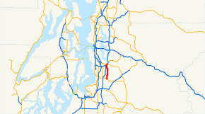
SR 515 is highlighted in red. | ||||
| Route information | ||||
| Auxiliary route of I‑5 | ||||
| Defined by RCW 47.17.705 | ||||
| Maintained by WSDOT | ||||
| Length: | 7.86 mi[1] (12.65 km) | |||
| Existed: | 1964[2] – present | |||
| Major junctions | ||||
| South end: |
| |||
|
| ||||
| North end: |
| |||
| Location | ||||
| Counties: | King | |||
| Highway system | ||||
| ||||

State Route 515 (SR 515) is a 7.86-mile-long (12.65 km) state highway in the U.S. state of Washington serving King County. The highway travels north from SR 516 east of Kent to Renton, intersecting Interstate 405 (I-405) and ending at SR 900. Originally signed as Secondary State Highway 5C (SSH 5C) in 1937, the highway was established during the 1964 highway renumbering and expanded to its current four-lane width in the 1960s.
Route description
SR 515 begins as 104th Avenue at an intersection with SR 516 east of Kent and Kent-Meridian High School.[3][4] The four-lane highway travels north, parallel to the SR 167 freeway, into the census-designated place of East Hill-Meridian on 108th Avenue and passes Panther Lake.[5][6] SR 515 turns northwest into Renton on Benson Drive and Talbot Road and descends from Talbot Hill,[7][8] intersecting I-405 in an incomplete diamond interchange.[9] In Downtown Renton, the highway travels northeast on Grady Way and north on Martin Avenue, paralleling I-405, before crossing a BNSF Railway line on Houser Way and ending at an intersection with 3rd Street,[10] signed as SR 900.[1][11][12]
Every year, the Washington State Department of Transportation (WSDOT) conducts a series of surveys on its highways in the state to measure traffic volume. This is expressed in terms of average annual daily traffic (AADT), which is a measure of traffic volume for any average day of the year. In 2011, WSDOT calculated that between 11,000 and 44,000 vehicles per day used the highway, mostly in Downtown Renton between I-405 and SR 900.[13]
History
SR 515 was created during the 1964 highway renumbering as the successor to SSH 5C,[14] which was established in 1937 and ran south from Renton to Kent.[15] The highway was paved in the 1950s and expanded to the modern four-lane highway it is today in the 1960s.[16][17] The interchange with I-405 in Renton was reconstructed in 2010 to add a flyover ramp over Benson Road from southbound I-405 to SR 515 and opened to traffic in 2011.[18]
Major intersections
The entire highway is in King County.
| Location | mi[1] | km | Destinations | Notes | |
|---|---|---|---|---|---|
| Kent | 0.00 | 0.00 | Southern terminus | ||
| Renton | 6.86– 6.94 | 11.04– 11.17 | Interchange, northbound entrance and southbound exit | ||
| 7.86 | 12.65 | Northern terminus, continues as Main Avenue | |||
| 1.000 mi = 1.609 km; 1.000 km = 0.621 mi | |||||
References
- 1 2 3 Staff (2012), State Highway Log: Planning Report 2011, SR 2 to SR 971 (PDF), Washington State Department of Transportation, pp. 1573–1578, retrieved February 5, 2013
- ↑ "47.17.705: State route No. 515", Revised Code of Washington, Washington State Legislature, 1970, retrieved February 5, 2013
- ↑ "Feature Detail Report for: Kent", Geographic Names Information System, United States Geological Survey, September 10, 1979, retrieved February 5, 2013
- ↑ "Feature Detail Report for: Kent - Meridian High School", Geographic Names Information System, United States Geological Survey, September 1, 1990, retrieved February 5, 2013
- ↑ "Feature Detail Report for: East Hill-Meridian Census Designated Place", Geographic Names Information System, United States Geological Survey, March 11, 2008, retrieved February 5, 2013
- ↑ "Feature Detail Report for: Panther Lake", Geographic Names Information System, United States Geological Survey, September 10, 1979, retrieved February 5, 2013
- ↑ "Feature Detail Report for: Renton", Geographic Names Information System, United States Geological Survey, September 10, 1979, retrieved February 5, 2013
- ↑ "Feature Detail Report for: Talbot Hill Substation", Geographic Names Information System, United States Geological Survey, June 7, 2010, retrieved February 5, 2013
- ↑ SR 405 - Exit 3: Junction SR 515 (PDF), Washington State Department of Transportation, April 25, 2012, retrieved February 5, 2013
- ↑ 2011 Washington State Rail System (PDF) (Map). Washington State Department of Transportation. January 2012. Retrieved February 5, 2013.
- ↑ Google (February 5, 2013). "State Route 515" (Map). Google Maps. Google. Retrieved February 5, 2013.
- ↑ SR 900: Junction SR 900 CO 2nd Street (PDF), Washington State Department of Transportation, May 4, 2009, retrieved February 5, 2013
- ↑ Staff (2011), 2011 Annual Traffic Report (PDF), Washington State Department of Transportation, pp. 193–194, retrieved February 5, 2013
- ↑ Prahl, C. G. (December 1, 1965), Identification of State Highways (PDF), Washington State Highway Commission, Department of Highways, retrieved February 5, 2013
- ↑ Washington State Legislature (March 18, 1937), "Chapter 207: Classification of Public Highways", Session Laws of the State of Washington, Session Laws of the State of Washington (1937 ed.), Olympia, Washington: Washington State Legislature, pp. 1002–1003, retrieved February 5, 2013,
(c) Secondary State Highway No. 5C; beginning at Renton on Primary State Highway No. 2, thence in a southerly direction by the most feasible route to a junction with Secondary State Highway No. 5A in the vicinity east of Kent.
- ↑ Seattle, 1958 (JPG) (Map). 1:250,000. United States Geological Survey. 1958. Retrieved February 5, 2013.
- ↑ Seattle, 1965 (JPG) (Map). 1:250,000. United States Geological Survey. 1965. Retrieved February 5, 2013.
- ↑ Peer, Steve (December 2010), I-405 - I-5 to SR 169 Stage 2 Widening - Complete December 2010, Washington State Department of Transportation, retrieved February 5, 2013