Washington State Route 546
| ||||
|---|---|---|---|---|
|
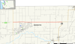
Map of Whatcom County in northwestern Washington with SR 546 highlighted in red | ||||
| Route information | ||||
| Auxiliary route of [[Interstate 5 (Washington) |]] | ||||
| Defined by RCW 47.17.805 | ||||
| Maintained by WSDOT | ||||
| Length: | 8.02 mi[1] (12.91 km) | |||
| Existed: | 1964 – present | |||
| Major junctions | ||||
| West end: |
| |||
| East end: |
| |||
| Location | ||||
| Counties: | Whatcom | |||
| Highway system | ||||
| ||||

SR 546 is a state route in Washington state. It goes from SR 539 near Lynden to SR 9 near Sumas.
Route description
SR 546 begins at SR 539 and proceeds east until it reaches SR 9. The highway is also known as Badger Road. The road connects Lynden to Sumas, and is the WSDOT-designated route from Interstate 5 to the Sumas border crossing.
History
Before 1964, SR 546 was a branch of Secondary State Highway 1B (SSH 1B).
SSH 1B, added to the state highway system in 1937, began at Jct PSH 1 (US 99, now I-5) in Bellingham and ran north via Lynden to the Canadian Border. An east–west branch, starting at a junction with the SSH 1B trunk just north of Lynden and heading east to Jct SSH 1A a few miles SW of Sumas, was added in 1957. This east–west branch had been part of SSH 1A from 1937 to 1953.
The north south route of SSH 1B was posted as Alt US 99 from 1954 to 1969. This route is now SR 539, the east–west branch, SR 546.
Major intersections
The entire highway is in Whatcom County.
| Location | mi[1] | km | Destinations | Notes | |
|---|---|---|---|---|---|
| Lynden | 0.00 | 0.00 | Western terminus | ||
| | 8.02 | 12.91 | Eastern terminus | ||
| 1.000 mi = 1.609 km; 1.000 km = 0.621 mi | |||||
References
- 1 2 Washington State Department of Transportation. "State Highway Log, 2006" (PDF). Retrieved April 22, 2007.